
Résumés
Abstract
This paper describes how new cartographic and information technologies were used to record and represent Inuit geographic and environmental knowledge in Igloolik, Nunavut. The method proved a powerful tool to document an approach to geography that is mainly oral. It was also helpful in documenting how people relate to a highly dynamic environment as the Arctic. The method includes the merging of different geographic databases that acquire full meaning when seen as layers of the same map. It also involves the search for new ways of representing, including simulated horizons, photographs of horizons embedded on maps, and recordings of oral descriptions of trails and locations. An example of such method can be seen in the Igloolik Multimedia Project, a CD-Rom that is being currently piloted in the Igloolik high school.
Résumé
Cet article décrit comment de nouvelles technologies cartographiques et de l'information sont utilisées pour recueillir et représenter les savoirs géographiques et environnementaux des Inuit d'Igloolik au Nunavut. Cette méthode s'avère un excellent outil pour documenter une approche de la géographie qui est principalement orale. Elle est aussi utile pour documenter comment les gens font face à un environnement aussi dynamique que celui de l'Arctique. La méthode inclut la fusion de différentes banques de données géographiques qui ne peuvent être bien comprises que lorsque vues comme des couches d'une même carte. Elle comprend aussi l'investigation de nouvelles façons de représenter, tels que les horizons simulés, les photographies d'horizons à même les cartes et l'enregistrement de descriptions orales des sentiers et des lieux. Un exemple de cette méthode est le Igloolik Multimedia Project, un cédérom qui est présentement en phase pilote dans l'école secondaire d'Igloolik.
Corps de l’article
Introduction
Every year, numerous search and rescue operations take place among the predominantly Inuit communities of Nunavut, in the Canadian Arctic. The situations in which these operations are called up vary from cases of people becoming lost, travellers getting stuck due to mechanical failures in their snowmobiles or boats, or hunters falling through thin ice. An increasingly common situation occurring in Igloolik, but also in other communities of Nunavut, refers to relatively young Inuit travellers who, being lost or stuck out on the land, are unable to convey their precise geographic location to more experienced Inuit through a radio communication. It is broadly accepted in Igloolik that some younger travellers lack some orienting techniques and geographic knowledge not only to transmit their precise locations or travel trajectories, but also to travel safely. These include the knowledge and understanding of Inuktitut place names, wind directions, well-established trails, characteristics of the sea ice, snow patterns, weather prediction, and star positions and trajectories. GPS (Global Positioning System) units are being increasingly used by Inuit hunters (Aporta and Higgs in press), but their mechanisms can break or freeze, and, more importantly, they do not solve important communication gaps between younger and older generations
The learning and teaching of geographic knowledge used to take place out on the land, frequently while moving through the territory with the relatively slow motion of the dog-sled. The context for learning has greatly changed, as elders do not often find a suitable context for transmitting what they know to younger generations, and formal education does not generally focus on local knowledge (i.e. local geography, local geology, local history and prehistory), and even less on Inuit knowledge. At the same time, several aspects of this knowledge have been and are being recorded through hundreds of interviews of a local oral history project, as well as through place names initiatives, and research on Iglulingmiut’s wayfinding and orienting techniques. This paper will present a brief description of some of the challenges and possibilities of documenting, representing, and communicating Iglulingmiut’s oral geographic knowledge, based on my fieldwork in Igloolik.
Documenting and representing horizons and journeys
By Iglulingmiut’s geographic knowledge I refer to the knowledge of surrounding (in a very broad sense) geographic features and environmental phenomena, and of present and past use of the territory that have being transmitted from generation to generation through oral means. This very broad concept includes the knowledge of place names, traditional routes, and of the skills and techniques required to travel and orient through the territory. One of the most revealing aspects of the Inuit approach to the territory is the fact that, without the use of maps, travellers break trails, year after year, often following the same spatial courses, whose only variations are generally related to snow and ice conditions. It is possible to establish the historic continuity of routes from multiple sources, including interviews, oral history, and the notes and maps of explorers and ethnographers. One of the main characteristics of arctic trails is that they totally or partially disappear from the landscape every season and sometimes within the same season. Trails are broken once and again on trackless snow, but most of them follow old, well-established courses, usually bordered by well known named places. Routes, therefore, are permanent features in Igloolik hunters’ memories, but trails (made of tracks) are ephemeral (Aporta 2004).
Traditionally, the Inuit have used a method of geographic representation that greatly differs from map views of the territory employed in most western societies, which is also the basis of the teaching of geography in school (in Igloolik and elsewhere). The Inuit method is based on precise oral descriptions of the territory, where horizons are depicted as the speaker recalls them from actual travel, and named places and other features are called up as seen or imagined from particular standpoints. Furthermore, horizons and features are oriented using wind bearings rather than magnetic cardinal points. The nature of this geographic knowledge presents a challenge to the researcher and to the cartographer. Beyond the map is the horizon (the actual landmarks or seamarks as seen or described), and beyond the trail (which can be mapped) is the journey (which cannot). The journey is the irreplaceable and unique experience of traveling the trail (there is one trail, but there could be many journeys: as many as the traveller has undertaken). The map is the representation of the land that never changes, while the horizon is always changing and the true knowledgeable hunter (which never gets lost and always knows where he is[1]) is the one that can relate his position and his direction in relation to the changing landmarks, icemarks, and skymarks in the horizon. Mapping the trail or the place name covers but one of the many dimensions of Inuit travelling.
The journey and the horizon cannot, by their very nature, be fully documented, but an effort can be made to represent such an approach in a more comprehensive way, by integrating different dimensions of travelling and combining maps with horizons, routes with place names and wind bearings, and visual representations with oral descriptions. I have used new mapping technologies and Geographic Information Systems (GIS) to overcome some of the limitations of traditional mapping. The results of these experiences in documenting and representing the Inuit approach to the territory have been well received in several public presentations in Igloolik, especially among students and instructors of the local secondary school, and elders of the Inullariit Elders Association[2].
Combining routes and names
Joining different geographic databases as layers of a GIS map allows a more comprehensive representation of the Iglulingmiut’s geographic knowledge. GIS permits to overlap, for instance, historically used Inuit routes with known place names. The combined representation of both databases illustrates how Inuit travellers perceive named places while travelling, and shows how these toponyms can be used during oral descriptions of routes. One of the routes that connects the islands of Igloolik and Saglarjuk, for instance, is bordered by named places that Inuit will use when giving oral directions of the route. Figure 1 shows a GPS recording of the route, and Figure 2 the place names mapped during a toponymic project in the mid-1980s. Both maps use information from two different databases. The GPS recording of the route (Figure 1) was obtained while following a hunter who was leading the way. The GPS unit, which was left working all along the trip, registered a very precise travel course. The place names database (Figure 2) was mainly built from toponyms collected by Emile Imaruittuq and André Uttak, as part of the Government of the Northwest Territories’ Geographic Names Program (SINT 1993).
Several of the named features around the trail are important landmarks that the traveller sees on the horizon or encounters on the trail. Kiggavialik, for instance, is a cliff that the traveller will aim when crossing the strait, and Quukinniq (“the narrow part”) marks a particular section in which the strait narrows down. The names are better understood and the trail better appreciated when both databases are put together, as Figure 3 shows.
Altering the perspective of maps
Beyond combining the databases, we can still go a step further by altering the perspective of the map to simulate a horizon-like view of the territory. Named features can be better appreciated when imagined in the horizon as travelling takes place. Figure 4 shows the same route and names of Figure 3. The route between Igloolik and Qakkiaq is approximately 85 km. Names like Kiggavialik (the cliff on the other side of the strait), Atikittuq (a raised beach), and Qakkiaq (a hill) will help the traveller stir his way. He will also be able to recognize features and to make an oral description of the trail or of his current position by identifying segments of the route with named places.
Photographing named places as viewed from trails
In formal education, the most frequent way of teaching geography is through maps of different scales and themes. Among the Inuit of Igloolik, a common method of teaching geographic knowledge is for older hunters to ask their young companions (frequently children and teenagers) to point out in the horizon at the location of certain (named) landmarks or settlements. Although it would be practically impossible (and pointless) to represent horizons from any location in any possible direction, the essence of this Inuit method of teaching geography can be fruitfully illustrated with test cases. Photographs of several significant landmarks taken from traditional trails or camping locations can be an alternative way of representing routes and place names. Figure 5 shows how the hill Qalirusiq (the highest geographic feature of the island of Igloolik) is seen from the facing shore of Avvajja. The horizon has been oriented using the wind direction Nigiq, similar to East-South-East of a magnetic compass rose.
Figure 1
A GPS track of a route between the islands of Igloolik and Saglarjuk in December 2000.
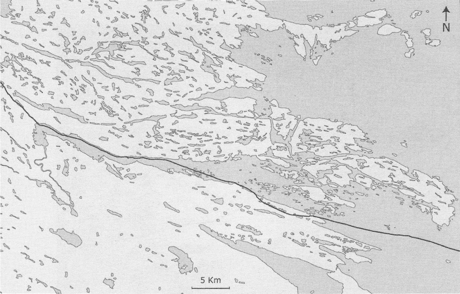
Figure 2
Dots represent named places. Most of the names were collected in the mid-1980s.

Figure 3
The names and the route as layers of a GIS map. For visual purposes, only some names are shown in writing.

Figure 4
A horizon-like view of the map gives an impression on how landmarks are seen from the trail.

Figure 5
Place names on a typical Igloolik horizon.

Mapping dynamic environments
GPS units can be used to record, on location, features that are significant aspects of the Inuit geographic knowledge, but that are not visible on ordinary topographic maps. These include ice features (ice ridges, ice leads, ice piled-ups, polynyas), submarine features, as well as the precise location of such small landmarks as boulders and stone cairns (see Aporta 2002, 2003).
Identifying oral descriptions
The Igloolik Oral History Project[3] contains innumerable narratives of journeys, and descriptions of routes and the territory. In fact, most stories told by Inuit elders (women and men) take place in concrete places, and travel frequently plays a role in the narrative. Vistas are constantly described, place names mentioned, and wind directions called-up. It is not infrequent for elders to mention from where the wind was blowing as they recall a particular event. One example of such a narrative can be found in a recording made in March 1990, in which a hunter then in his late 30 (George Qulaut) asked an experienced Inuk (Mark Ijjangiaq) about the route between Igloolik and Naujaat (Repulse Bay). This route has been used as far back as anyone in Igloolik can remember, and travel between the Iglulingmiut settlements and the Naujaat region was already reported by explorers Parry (1969 [1824]) and Lyon (1970 [1823]). Archaeologist and explorer Graham Rowley (1996: 67) also used this route in his expeditions of the 1930s. This was indeed a frequently travelled route when trading and whaling became important in the lives of the Iglulingmiut, Repulse Bay being their chief trading destination. Inuit still travel this route to visit relatives. Qulaut was intending to make the trip himself when he interviewed Ijjangiaq in 1990.
According to Ijjangiaq, the route to Naujaat was known as Kivavaq, and the journey itself as Kivavaan (“southbound”)[4]. Ijjangiaq recalled that this land trail (there is very little sea-ice travelling) was generally broken by a very experienced hunter named Aakuannuk. The trail is not a straight line through the mainland of Melville Peninsula. Instead, it follows a meandering course that favours smooth travel and frozen water surfaces (rivers, creeks and chains of lakes). The description of the route is not a simple depiction of geographic features. In the following excerpt, Ijjangiaq is actually remembering concrete travel, and frequently “interrupts” his description to make what may seem to be long “detours” into anecdotes of a specific trip:
The largest lake closest is called NAGVAAQ, the one pass it where there are rough lands around it is called SANNINGAJURULUK where there is another lake pass it. Both side of the lake are full of QIGGUQ where there are boulders and boulders of rocks, so one must go through this lake as there is no other route to take. After SANNINGAJURULUK the lake is called TASIRAUJAQ just before the lake QUKIUTITALIK. This TASIRAUJAQ is a long lake so that you can go through it for a long time. It has been many years now that I did not use the route but I still remember the route […]. Once you get to QARIAQ where you will get to the sea by a long stretch of a inlet as you pass a point to your right you will start going towards NAUJAN you will come across an isthmus which is part of a long point where there are rocks on the shoreline which is not an obstacle as you would be able to clear your sled away from them, this long point is called IGLOOLIK. This is where you get to the sea after going through the isthmus after which you will be crossing the inlet QARIAQ towards NUVUJJUAQ which is part of NAUJAN. The land just before NAUJAN is called NUVUJJUAQ which runs towards NAGJUTTUUQ which is a long point.
Ijjangiaq 1990
Narratives like Ijjangiaq’s also permit to have a much better understanding of the Inuit relationship with their territories. During 2006, and with help from different hunters and several collaborators, a research project will focus on careful documentation of traditional routes, including the recording of oral descriptions of journeys linking Igloolik with other communities.
CD-Rom on Inuit geographic knowledge
Beyond my own research, several other research and oral history projects (some of them already mentioned above) have recorded significant aspects of the way Inuit in Igloolik understand and relate to their environment. These projects (e.g., MacDonald 1998) have documented the Inuit knowledge and use of snowdrifts, sea ice conditions, tidal shifts, winds, toponyms, lunar phases, weather prediction, understanding of animal behaviour, star trajectories, etc. In several formal and informal meetings, Inuit elders expressed interest in those topics, and in the methods I was using to represent geographic knowledge. It was also agreed that younger Inuit were lacking former contexts and opportunities to learn the knowledge and skills related to travelling. As a consequence of this interest, we decided to produce a CD-Rom containing visual, written and audio documentation in a way that could be fruitfully used by younger people, especially in the context of formal education.
The project has incorporated the input of local elders, language specialists, school instructors, artists, as well as consultants and researchers. It is supported with the financial and logistic assistance of several organizations[5]. The objective is to produce a CD-Rom that reflects the many dimensions of Inuit geographic knowledge and wayfinding and travelling techniques, which could be incorporated into the curricula of local schools and might become a model for similar projects in other communities of Nunavut. A teachers’ book is being prepared by local instructors to accompany the CD-Rom and provide tools for its use in the classroom. The CD-Rom is presently being piloted in several classes at the Igloolik high school and it will be released for use in other schools of Nunavut in September 2006. This project does not pretend to replace the actual experience of travelling, but hopes to create new opportunities for learning by stimulating young Iglulingmiut’s desire to talk to their elders and to go out on the land. The teacher’s guide includes several exercises that involve elders going to the classroom, and also direct observation of winds, stars, etc.
Conclusion
Documenting oral knowledge in the context of a community like Igloolik should not be approached with the only purpose of saving this knowledge from oblivion. Documenting data with this single purpose would not be too different from collecting artefacts of a vanishing culture for museum display. In the context of this paper, the different aspects of Inuit geographic knowledge are much more than pieces of information that make a picture of ancient lore, but parts of a whole that reveals a particular approach to the environment that is still valid and useful today, both for cultural and survival reasons. Research and oral history projects which focus on the documentation of Inuit Qaujimajatuqangit (IQ) often stop in the registering stage, without seeking to develop creative and effective ways of representing and delivering back such data to local communities. The creative use of oral history and knowledge can be an opportunity for researchers and organizations to make a contribution towards the community in which they have done their work.
Parties annexes
Notes
-
[1]
Every hunter gets lost once in a while. What makes the difference is the ability to rebuild a sense of orientation, and the knowledge of what to do in such cases. Several knowledgeable Inuit elders say they are not really lost but temporarily misplaced or disoriented
-
[2]
I presented the results of my research to the Inullariit Elders Association in March 2001, and I gave a series of school presentations in March 2004.
-
[3]
The Igloolik Oral History Project is a collaborative, on-going program run by the Inullariit Society of Igloolik and the Igloolik Research Centre since 1986.
-
[4]
According to Aqiaruq (1993), Kivavaq means “Heading towards the direction of the day.”
-
[5]
These are: the Social Sciences and Humanities Research Council (SSHRC), the CURA project “Memory and History in Nunavut”, the Nunavut Research Institute, the Department of CLEY (Culture, Language, Elders and Youth, Nunavut Government), and the Centre Interuniversitaire d'Études et de Recherches Autochtones (CIÉRA) of Université Laval.
References
- APORTA, Claudio, 2002 Life on the ice: Understanding the codes of a changing environment, Polar Record, 38(207): 341-354.
- APORTA, Claudio, 2003 Using GPS mapping software to map Inuit place names and trails, Arctic, 56(4): 321-327.
- APORTA, Claudio, 2004 Routes, trails and tracks: trail-breaking among the Inuit of Igloolik, Études/Inuit/Studies, 28(2): 9-38.
- APORTA, Claudio and Eric HIGGS, in press Satellite Culture: Global Positioning Systems, Inuit Wayfinding, and the Need for a New Account of Technology, Current Anthropology.
- AQIARUQ, Zachariasie Uqalik, 1993 Interview for the Igloolik Oral History Project, unpublished manuscript (no. IE-269) on file, Igloolik, Igloolik Research Centre, Archives of the Inullariit Society.
- IJJANGIAQ, Mark, 1990 Interview for the Igloolik Oral History Project, unpublished manuscript (no. IE-138) on file, Igloolik, Igloolik Research Centre, Archives of the Inullariit Society.
- LYON, George F., 1970 [1823] The Private Journal of Captain G.F. Lyon of H.M.S. Hecla During the Recent Voyage of Discovery Under Captain Parry, Barre, MA, Imprint Society.
- MacDONALD, John, 1998 The Arctic Sky: Inuit Astronomy, Star Lore, and Legend, Toronto, Royal Ontario Museum and Nunavut Research Institute.
- PARRY, William E., 1969 [1824] Journal of a Second Voyage for the Discovery of a Northwest Passage From the Atlantic to the Pacific, London, J. Murray.
- ROWLEY, Graham W., 1996 Cold comfort: My love affair with the Arctic, Montreal, McGill-Queen’s University Press.
- SINT (Science Institute of The Northwest Territories), 1993 Amitturmiut place names, Igloolik, Igloolik Research Centre.
 10.7202/013194ar
Liste des figures
Figure 1
A GPS track of a route between the islands of Igloolik and Saglarjuk in December 2000.
Figure 2
Dots represent named places. Most of the names were collected in the mid-1980s.
Figure 3
The names and the route as layers of a GIS map. For visual purposes, only some names are shown in writing.
Figure 4
A horizon-like view of the map gives an impression on how landmarks are seen from the trail.
Figure 5
Place names on a typical Igloolik horizon.