
Résumés
Abstract
Late Dorset dwellings from two sites on Little Cornwallis Island (Nunavut) illustrate the diversity of architectural forms from this period. Ten architectural features are described. They include five tent rings, ascribed to warm season occupations, and five rectangular semi-subterranean houses with axial features, including one exceptionally well-preserved example, ascribed to cold season occupations. Variations in size, number of hearths, and construction techniques are examined and the use of both types of structures to house multiple nuclear families is suggested.
Résumé
Les habitations du Dorsétien récent de deux sites de l'île Little Cornwallis (Nunavut) illustrent la diversité des formes architecturales de cette période. Dix structures architecturales y sont décrites. Elles incluent cinq cercles de tentes assignés à des occupations en saisons chaudes, et cinq maisons semi-souterraines rectangulaires avec aménagement axial, dont un exceptionnellement bien préservé, sont associées à des occupations en saison froide. Les variations au niveau de la taille de l'habitation, du nombre de foyers et des techniques de construction sont examinées. Il est suggéré que les deux types de structures abritaient de multiples familles nucléaires.
Corps de l’article
Introduction
The Palaeoeskimo Architecture Symposium held in Saint-Pierre et Miquelon in 2002 made it clear we still have much to learn about the variability and meaning of the often enigmatic architectural remains we excavate. One of the primary goals of the symposium, as articulated by the organizers Sylvie LeBlanc and Murielle Nagy, was to generate a database of Palaeoeskimo habitation structures, as a starting point for further discussions. Accordingly, in this paper we focus on description of the various types of architectural features we excavated at two large Late Dorset sites on Little Cornwallis Island, including a detailed discussion of the careful excavation and reconstruction of an exceptionally well preserved axial passage structure. We address the meaning of these remains only briefly. One of us has ventured into this more speculative realm elsewhere (LeMoine 2003). Others will no doubt find additional or alternative meanings as well, but it is, indeed, the careful description of such remains that will make a variety of analyses interpretations possible for other researchers.
The sites
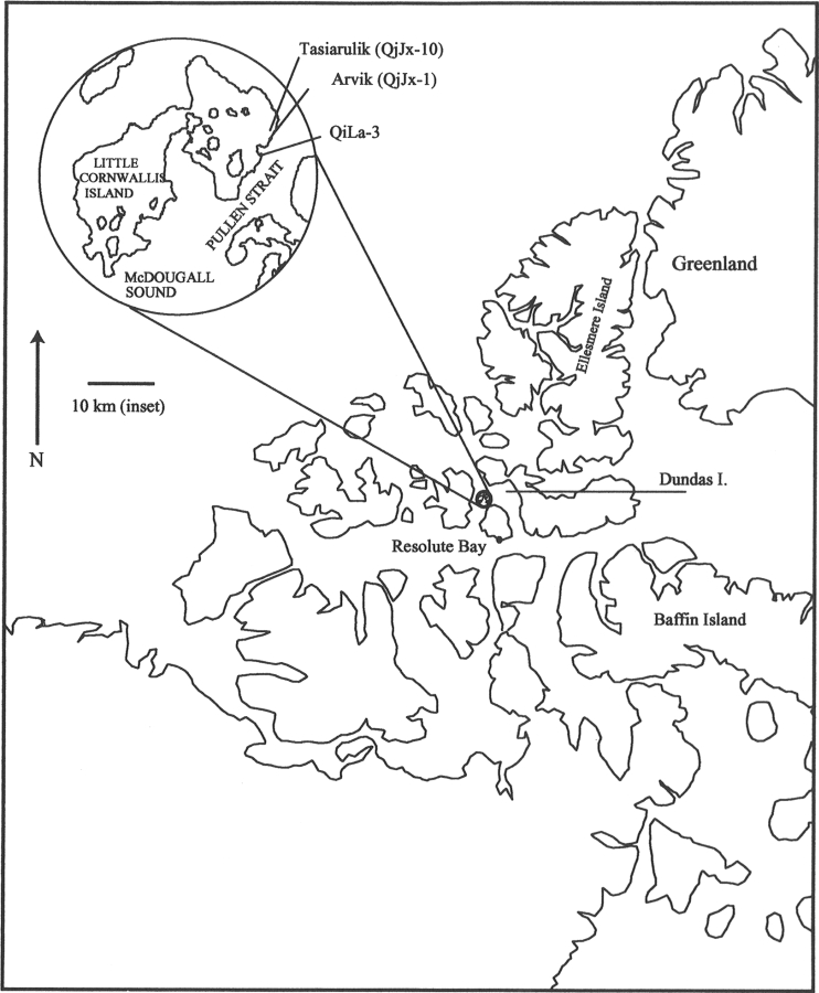
The two sites discussed here, Tasiarulik (QjJx-10) and Arvik (QjJx-1) are located only 1 km apart on northeastern Little Cornwallis Island in the Canadian Central High Arctic (see Figure 1). Over the course of three seasons, these sites were the focus of intensive surface and sub-surface investigation by field crews from the University of Calgary (Helmer et al. 1993, 1995a, 1995b) along with visiting researcher Bjarne Grønnow and students from Arctic College (Iqaluit) and Resolute Bay. Some aspects of this research have been published elsewhere (Helmer and LeMoine 2002; LeMoine 2003; LeMoine and Darwent 1998; LeMoine et al. 1995) but this is the first full reporting of the architectural remains at these sites.
The sites are on the same fossil beach, 5-8 m above sea level, and share a number of characteristics, from their size to specific aspects of their location. Both sites are partially located below a low rocky outcrop. Surveys carried out by Helmer in 1989 on the fossil beaches above the sites identified Early Dorset sites and scattered earlier Palaeoeskimo occupations, as well as caches and at least one Dorset burial (Helmer 1989). Currently there are freshwater ponds and boggy areas between the outcrop and the sites. These may have been brackish or even tidal during occupation. A permanent snow bank has built up below the outcrop as well. Although the two sites are close, only 1 km apart, the intervening beach shows no signs of occupation. The sites themselves, by contrast, were heavily occupied. At each site we identified about 100 features, including a variety of architectural forms, outdoor activity areas, middens, and caches. Architectural features included tent rings, shallowly excavated axial passage structures, and one long house (not excavated) at Arvik.
Figure 1
Map showing the location of sites
Arvik (QjJx-1)
Arvik stretches for about 400 m along a gravel beach now 5 m above sea level (Figure 2). The site can be divided into a northern and a southern half, separated by about 50 m of beach where there are no habitation features or middens, although there are a few caches. Features at Arvik are well defined and clearly visible on the surface. Our impression is that Arvik was used for a shorter period of time, or less often, than Tasiarulik (see below). Radiocarbon dating of the site has been problematic because a number of the samples submitted for dating were collagen depleted and so returned unreliable dates. Two reliable dates are early in the Late Dorset sequence, calibrated to A.D. 544-530 and A.D. 620 (Beukens 1995, see Table 1). Chronologically diagnostic artefacts from the site, such as Ha1 harpoon heads, support an early occupation but others, such as type G harpoon heads with rivet holes for metal end blades, argue for latter occupations as well. Since it is unlikely that many of the habitation features at the site were occupied simultaneously, it seems probable that the site was reused over a number of years, although our current radiocarbon date sample does not reflect this.
Tasiarulik (QjJx-10)
Tasiarulik is a somewhat larger, and more intensively occupied site than Arvik although the two share many similarities. Tasiarulik can be divided into three areas (Figure 3). In the northern and southern areas, features are distinct and well defined, but in the central area there is a complex palimpsest of dwellings, middens and activity areas suggestive of very intensive occupation and reoccupation. Calibrated radiocarbon dates from Tasiarulik also suggest a longer history, ranging from A.D. 540 to 1275, (Beukens 1993, see Table 1) reflected in the number and distribution of features.
One of our research goals was to assess inter- and intra-site variability in both artefact assemblages and architecture. Thus from the many features at each site we elected to examine a sample of tent rings and axial feature structures, along with what we hoped were associated middens. Ultimately, guided in part by the usual time constraints, we excavated two features of each architectural type at Arvik and three at Tasiarulik. All of the features at both sites are essentially on the surface and even middens are very shallow — usually less than 10 cm deep. Many show signs of post-occupation disturbance both human and otherwise. In particular, architectural rocks, and possibly whale bone, were probably reused by returning families with some frequency. In some areas, such as the central area of Tasiarulik, it was also clear that we were dealing with multiple over-lapping occupations that were impossible to disentangle. Additionally, in the centuries after human occupation ended, lemmings frequently colonized the sod-rich semi-subterranean house ruins causing moderate to extensive damage.
In the descriptions that follow, tent rings from each site are discussed first, followed by the semi-subterranean axial feature dwellings, and including a discussion of the reconstruction of the best-preserved axial feature structure, Feature 49 at Arvik.
Figure 2
Map of Arvik (QjJx-1)

Figure 3
Map of Tasiarulik (QjJx-10)

Tent rings
Tent rings at each site were at some risk during Late Dorset times, as the sites were both reoccupied over many years. As a result, few if any of the rings were complete. At both sites we selected those that appeared to be most intact and were fortunate that at each site at least one ring had even internal features preserved. At Arvik, 34 tent rings were identified on the surface, and two were excavated.
Arvik Feature 53
Feature 53, the best preserved of these, is an oval tent ring, 4 m long by 3 m wide (external) in the southern part of the site (Figure 4). On the surface it was clear that not all the ring rocks were in place, but internal features appeared undisturbed and the ring was covered by only a very thin veneer of vegetation. There were two lamp stands inside the ring — each a large boulder with a slightly dished flat surface reddened from exposure to heat — one in the north half and one in the south half. There were also two small hearths adjacent to the lamp stand in the south half of the ring (Figure 5). Each of these was composed of two small upright slabs, one against the lamp stand, with the other at right angles to it. Each had a small flagstone on the gravel, in the angle formed by the two uprights. Sitting on the gravel, the top of the flagstone is lower than the surface of the adjacent lamp stand, which, along with the uprights, may have provided some protection from the wind. The hearth on the east side of the lamp stand contained carbonized blubber and other burnt material.
We have been working on the assumption that tent rings were warm season occupations, and although sparse, the faunal remains from Feature 53 support this — the sample is dominated by migratory bird bones[1]. The artefact sample was also relatively small — just over 200 objects including flakes, wood fragments and other debitage. Diagnostic artefacts include a type G harpoon head (and an antler end blade that fits the slot perfectly), chert end scrapers with flared ends, three typically Dorset needles, and eight small fragments of iron.
Arvik Feature 12
The second tent ring excavated at Arvik, Feature 12, located in the northern section of the site, was disappointing (Figure 6). On the surface it appeared as an amorphous, discontinuous, ring of rocks with a thin veneer of vegetation, and a few artifacts visible. There were no internal features present, and preservation of both artifacts and faunal remains was poor. Only 37 artifacts were recovered, but these included such characteristically Late Dorset pieces as three type G harpoon heads and one triangular end blade with a shallow concave base. Two soapstone lamp rim fragments were found, as were a surprising 31 fragments of wood, including a bi-pointed barb. A metal detector survey before excavation revealed that there was one piece of metal present, a poorly preserved iron blade. The small faunal assemblage is dominated by fox but includes seal bone along with a single caribou bone. Fox bones may be considered a cold-season indicator (Darwent 2001; Murray 1996), complicating our classification of this ephemeral feature as a warm-season tent-ring.
Figure 4
Plan of Feature 53 at Arvik
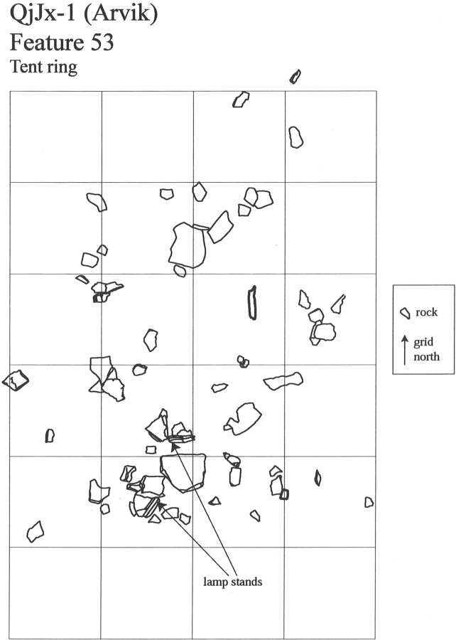
Figure 5a
Hearth/lamp stands in Feature 53 at Arvik: south hearth

Figure 5b
Hearth/lamp stands in Feature 53 at Arvik: north hearth

Tasiarulik Feature 30
We were fortunate to excavate a very well-preserved tent ring at Tasiarulik, Feature 30 (Figure 7). Although excavation was somewhat hindered by late summer snow, the preservation of F-30 was remarkable. The ring itself was large, measuring 5 m x 5.5 m A small midden, Feature 31, directly to the east (shore-ward) is probably associated. The only discernable interior features were a small rectangular arrangement of slabs in the northeast quadrant and a central fire-reddened slab and boulder cluster. These were identified in the field as a possible cache and as a hearth. Like Feature 53 at Arvik, the small faunal assemblage was dominated by migratory bird bones, as was the assemblage from the nearby midden. In this case however, the artefact sample is relatively large — over 2,200 objects, including dense concentrations of chert flakes, as well as abundant antler shavings and ivory flakes. Diagnostic artifacts recovered include an Ha-1 harpoon head, along with the base of a type F or G harpoon head, triangular end blades with concave bases, asymmetric knives, typically Dorset needles, and small fragments of both iron and copper. An AMS date on a piece of caribou antler from this feature resulted in a date of 1450 ± 60 B.P. (cal A.D. 590-655) (Beukens 1993, see Table 1).
Tasiarulik Feature 79
We also excavated two other tent rings at QjJx-10, of the 13 identified at the site, neither as well preserved as Feature 30. One of these, Feature 79 (Figure 8), was part of a complex of overlapping features in the intensively occupied central part of the site. In fact it, probably represents a series of rings from different years. We located multiple hearths or lamp stands, identified by reddening, but could not conclusively determine whether they were from one particular occupation. Similarly, the diverse faunal assemblage and the large artifact assemblage (over 8,000 pieces, mostly flakes) cannot be linked to a particular episode of occupation or even a particular dwelling.
Tasiarulik Feature 90
The third tent ring, Feature 90, is only tentatively identified as such — it had no remaining ring rocks, but a veneer of vegetation, a slab hearth and a concentration of significant artifacts indicated that it had been a dwelling (Figure 9). As there was neither an axial feature, a berm, or any evidence of excavation, we classified it as a tent ring from which rocks had been removed. Similar structures have been identified as snow houses, but the slab hearth seems to argue against this as such a construction would be of little use in a snow structure (Ramsden and Murray 1995; Savelle 1984). Both the faunal and the artifact assemblages were small. The faunal assemblage is dominated by seals, with low frequencies of other species. Of the 51 artifacts, seven were copper fragments. Other artifacts include fragments of one stemmed and one triangular biface, a needle blank, a possible awl, and a unique carving of a human/bear transformation, discussed in more detail elsewhere (LeMoine et al. 1995).
Figure 6
Plan of Feature 12 at Arvik

Figure 7
Plan of Feature 30 at Tasiarulik

Figure 8
Plan of Feature 74 and 79 at Tasiarulik

Discussion
The tent rings on Little Cornwallis Island follow comparable patterns and are broadly similar to tent rings described elsewhere for Late Dorset with the chief difference being that, based on size and number of hearths, some appear to have been multi-family dwellings. Tent rings on Little Cornwallis Island range in size from 3.5 m x 2.5 m to 5 x 5.5 m. This is considerably larger than the average size reported by Maxwell (1985) of a maximum dimension of 2-3 m, even considering the probable displacement and spread of rocks when the tent was taken down. Like Feature 53 described here, some of them may have had multiple hearths, suggesting two or more families had occupied them. None had any evidence for axial features, unlike those described as warm-season dwellings by McGhee (1981) on Dundas Island. The typically scant artefact assemblages, and in some case faunal assemblages, associated with most of them suggest that they were occupied only briefly, mostly, but probably not exclusively, in the summer. As is common with such relatively ephemeral structures, tent rings at both sites were often poorly preserved, with some or even all of the ring rocks removed, most likely for re-use elsewhere at the site. Thus some features identified by us as tent rings had no perimeter rocks at all, while others (such as Feature 79 at Tasiarulik) had only partial rings. The presence of stone hearths argues against any of these rings being snow houses, even though one of them (Feature 90) has no rocks around the perimeter.
Faunal assemblages dominated by warm season species, especially migratory birds, such as Feature 53 at Arvik and Feature 30 at Tasiarulik, further support the idea that these features are primarily summer occupations. Seasonality of some tent rings, in particular Feature 12 at Arvik, is more equivocal, with high percentages of species such as fox that are available year-round, but best hunted in the cold-season. We anticipate that on-going analysis will clarify the nature of these features, in particular considering the role of possible resource-stress contributing to less-than-optimal use of resources (Darwent 2001).
Artefact assemblages associated with tent rings, while typically smaller than those associated with other features, include tool-types of all sorts, from needles and lamp fragments to harpoon heads and knives. Despite their apparently ephemeral nature, it seems that a wide range of activities occurred in and around tents. One activity that is strongly represented in these samples is tool manufacture or maintenance. Feature 30 at Tasiarulik, with large numbers of chert flakes and antler shavings, is the best but by no means only example. Feature 90 at Tasiarulik seems to have been a locus of copper working, and the number of small iron fragments recovered from Feature 53 at Arvik suggest working of that material as well. This should not come as a surprise — the combination of light and comparatively warm weather alone suggests that the short summer is a good time to do fine manufacturing work. If the summer weather in the Late Dorset period was anything like it is now, it would also have been a poor time to hunt, with frequent rain and fog, particularly once the ice has broken up.
Axial passage houses
The other main category of dwellings identified on Little Cornwallis Island is the axial passage house, also called "winter" or cold-season houses, mid-passage structures, and semi-subterranean houses. Like tent rings, these were plentiful at both sites. They are typically shallowly excavated with a gravel berm and the characteristic axial feature composed of slabs or blocky dolomite boulders.
Tasiarulik Feature 59
At Tasiarulik we excavated three winter houses, all with axial features constructed of local dolomite boulders, and low gravel berms surrounding shallow rectangular depressions. All had evidence of considerable disturbance by lemmings and had been robbed of some architectural rocks. Feature 59 was the best preserved of these (Figure 10). Like all the "semi-subterranean" houses on Little Cornwallis Island, F-59 was very shallow — hardly excavated at all really, with perhaps just enough gravel moved to construct the berm. There was no evidence of the entrance, which was evidently not a cold trap in any case. The axial feature was well-defined, and typical of those found at this site, but somewhat different from "classic" axial features. It was constructed of blocky dolomite boulders, arranged into two roughly parallel rows about 1 m apart, bisecting the house on an axis perpendicular to the shore. Three hearth boxes, identified by oxidized stains on the rocks and the presence of some burned blubber and bone, were incorporated into the axial feature.
Feature 59 is dated at 1060 ± 80 (cal A.D. 890-1030) (Beukens 1995, see Table 1). Diagnostic artifacts include one type F harpoon head, an antler box wall, an asymmetrical chert knife, triangular end blades with concave bases, two ground burins, and a quartz crystal microblade core. The faunal assemblage is very small (106 pieces of which half were unidentifiable), but diverse. Seals predominate, but caribou, muskox, bird and fox bones are also present.
Tasiarulik Feature 74
We excavated two other winter houses at Tasiarulik, of 11 recorded at the site; Features 74 and 91. Both had gravel berms and axial features constructed of large dolomite boulders, like the one in Feature 59, with two hearths (and possibly three in 74). Feature 74, like Feature 79, is part of the complex of overlapping features in the central portion of the site, making it difficult to evaluate (Figure 8). Adding to this, the house was considerably disturbed by lemming burrows and possibly by reuse of architectural rocks. Like Feature 59, the axial feature was constructed of dolomite boulders in two parallel rows about 70 cm apart, perpendicular to the shoreline. The interior of the gravel berm measured 4 m x 4 m. At least two hearths were identified in the axial feature. Because of disturbance it was not possible to positively identify a third hearth. A cache pit between Feature 74 and a nearby midden could not be positively associated with the dwelling feature. The faunal assemblage from Feature 74 is heavily dominated by seal bones. Diagnostic artifacts include one type F (self-bladed) and two miniature Ha-1 harpoon heads. Numerous core fragments and needle fragments were also recovered.
Figure 9
Plan of Feature 90 at Tasiarulik

Figure 10
Plan of Feature 59 at Tasiarulik

Tasiarulik Feature 91
Feature 91 at Tasiarulik is very similar to the other axial passage features excavated there, although at 2.5 m x 3 m it is smaller (Figure 11). Like Feature 74 there, extensive lemming disturbance and re-use of architectural rocks were evident during excavation. The axial passage, built from blocky dolomite boulders, included two hearths. The small faunal sample is dominated by seal bone, but also includes small numbers of other species, including fish. Diagnostic artifacts include two harpoon head fragments, one a type E, and the other either a type F or type G.
Arvik Feature 9
At Arvik we excavated two of the eight winter houses. One of these, Feature 9, looked promising on the surface, with a few architectural rocks evident in a thick mat of vegetation, but proved to be poorly preserved, with few of the architectural rocks remaining in situ (Figure 12). Nor are the faunal and artefact samples large. The faunal sample, like that in the other axial passage features, is dominated by seal bones. Although small, the artefact sample is notable for the number of metal objects, including a fragment of an iron knife blade in its haft, a copper knife blade, a copper bar, possibly an awl preform, and a number of other clearly worked fragments. Other artifacts include two heavily weathered type G harpoon heads, a variety of needle fragments, two carvings, and an end blade with a pronounced v-shaped basal concavity.
Arvik Feature 49
The second semi-subterranean dwelling we excavated at Arvik, Feature 49, was extremely well preserved and was distinct from all the other such structures at both sites (although Don Hanna [1995a, 1995b] excavated a very similar house at a nearby site, QiLa-3, where it was the only dwelling). Like all the other houses on Little Cornwallis Island, Feature 49 was shallowly excavated with a low gravel berm surrounding a heavily vegetated interior in which two parallel rows of upright slabs, perpendicular to the coast, were visible prior to excavations (Figure 13). The internal measurements are 4.5 m x 4 m The thick mat of vegetation inside the house appeared to be the result of a collapsed sod wall. The outlines of some of the turves were still visible in the sod. Unlike the other houses at these two sites, the axial feature was carefully constructed of upright slabs 1 m apart and 4 m long, with a fitted pavement between them. Some of the uprights had fallen over but were still essentially in place, with flat paving stones between them. Two lamp stands with pot supports, and an anvil stone with a cobble hammer still in situ, were incorporated into the pavement.
Figure 11
Plan of Feature 91 at Tasiarulik

Figure 12
Plan of Feature 9 at Arvik

The only reliable radiocarbon date from this house is early: 1580 ± 60 (cal A.D. 455-530) (Beukens 1995, Table 1). A second sample submitted was depleted in collagen and the date came back as modern. Diagnostic artifacts include one Ha-1 harpoon head (considered to be early in the Late Dorset sequence), an antler box base, various carvings, triangular end blades and bifacial knives. In the faunal sample, seals predominated, but birds and fox are also present. This assemblage is similar to that from QiLa-3 (Hanna 1995a, 1995b).
The excellent preservation of this house led us to decide to re-build this remarkable house floor, a task undertaken primarily by one of the co-authors (B.G.), assisted by University of Calgary student Hugh Gibbons and more fully described below.
Discussion
At Tasiarulik, the three excavated semi-subterranean features are very similar, with moderately to well-defined gravel berms and axial features constructed of locally available dolomite boulders and containing 2-3 hearths or lamp stands. None of the axial features at Tasiarulik were paved although suitable flat stones are available (and were used at Arvik), nor was there any evidence for platforms, sleeping benches, or bedding material as described for some regions (Maxwell 1980; McGhee 1981). The houses range in size from 3 m x 2.5 m to 4.5 m x 4 m, with up to three hearths identified in the larger two houses and two in the smaller. With the exception of the whale mandible upright and obvious turves in Feature 49 at Arvik, we did not find clear evidence for wall construction or roofing, although this is not unusual for Late Dorset structures.
The semi-subterranean houses excavated at Arvik were similar in overall plan to those at Tasiarulik, but not identical. Feature 9 was the least well-preserved of any of the houses, with only a scatter of boulders indicating where the mid-passage had been and no good evidence for a hearth. Unlike the other houses, it also included a large (2 m x 2 m) cache in the berm, although this may be a latter, intrusive, element. Feature 49 is both the best preserved and the most interesting of the houses we excavated. A classic paved axial passage distinguishes Feature 49 from all other houses on Little Cornwallis Island with the exception of the isolated house at QiLa-3. Like that site, the single date from Arvik Feature 49 is very early (see Table 1) and the feature contained one Ha-1 type harpoon head, considered to be early in the Late Dorset sequence, although undated until now (Maxwell 1985). It is probable then, that despite its excellent preservation, Feature 49 was constructed by some of the earliest inhabitants at the site, perhaps some of the first families to return to the High Arctic after an occupational hiatus of hundreds of years. If this is correct, then the axial features constructed of boulders and lacking pavements are a later development. Why this change in axial passage construction occurred is not clear. Slabs, as opposed to boulders, are available nearby although boulders are more common. Functionally, a paved axial passage would seem to be more practical, providing a work surface (such as the anvil stone in Feature 49) as well as a locus for the hearth, but clearly the consensus among the inhabitants of Arvik and Tasiarulik was that boulders were, if not preferred, then at least adequate.
Figure 13
Plan of Feature 49 at Arvik

Faunal assemblages from axial passage features at both sites differ from tent ring assemblages in that they are most often dominated by ring seal bones, the staple of the Late Dorset diet. They typically also include a variety of other species from migratory birds to caribou, fox, and fish, indicative of broad-based use of local resources over multiple seasons (Darwent 2001). This pattern has been described for similar features elsewhere (e.g., Ramsden and Murray 1995).
Artefact assemblages from the axial passage features support the idea that they are cold-season dwellings, used (perhaps continuously) for many months between fall and spring. As with the tent rings, the artefact assemblages are relatively small, but with a wide range of activities represented, from sewing and clothing repair (needles, scrapers) to tool manufacture (cores, debitage). Preliminary analysis suggests that there is little or no difference in assemblage composition between tent rings and axial passage features, a rather surprising conclusion that we will examine more fully elsewhere.
Reconstructing Feature 49
We had a number of goals in undertaking this reconstruction. Most importantly, we felt that the complete dismantling prior to reconstruction and the re-building process itself would provide us with an understanding of the details of construction principles we would not otherwise have. Also, the reconstructed house floor could give professionals and visitors a three dimensional impression of a Late Dorset cold season dwelling. Further, the reconstruction would enhance our ability to interpret Dorset dwelling floors which, due to solifluction, lemming burrows or other disturbing elements, are normally not so well preserved. Indeed, Feature 49 was the only feature with any suggestion of a preserved dwelling floor at the site.
The process of reconstructing the feature was simple, and in the initial stages differed little from the techniques used on other features, but due to the complexity and preservation of the feature, required a good deal of careful work. First, we made detailed three dimensional maps of the structure stones and the floor, as well as taking photographs (including Polaroid photographs for easy reference in the field) from all angles (Figure 14). We then removed all structural stones in secondary positions and excavated cultural layers covered by these stones. Next, we removed the structural stones still in situ, placing them in their correct relative position on an even area beside the feature. Finally, we excavated the matrix below the flagging. Thus, the starting point of the re-building of the original house floor consisted of observations during excavation, Polaroid photos, drawn maps including the levels of the stones and the floor — and a large puzzle of flag stones which had to be put back into their "Dorset time" position in the axial passage.
It was decided to replace a few completely crumbled flagstones and to fill in and even out the parts of the floor destroyed by lemmings. It was further decided to attempt a reconstruction of the entrance in the front end of the axial passage as well as a supposed cache at the back end, even if these parts had originally been destroyed or rebuilt several times. The actual reconstruction of these parts must thus be seen as a simplification of the original situation.
During re-construction it became clear how carefully the Dorset architects had chosen their building materials. The flagstones forming the vertical sides of the axial passage as well as the large horizontal flagstones — the platforms of the axial passage — fitted together perfectly. It is likely that these dolomite rocks were shaped by knapping and breaking, but it is hard to document working traces in this kind of material. However, extensive traces of Dorset knapping of flag stones were seen on the edges of the "pot supports." They were made to fit the two heavy lamp stands of the axial passage and were placed upright on either side of them, perpendicular to the uprights of the axial passage. Embedded deep in the gravel, the lamp stands were heavy dolomite rocks — a qualified guess would be 30-40 kilos each. As with the lamp stands in Arvik Feature 53, they showed slightly concave upper surfaces that were probably artificially shaped. These lamp stands were carefully selected and probably transported to the site from a certain distance. Today at least, no rocks of this size and shape are found in the scree of the site catchment.
The impression of careful Dorset architecture was further underlined by the following observations. The side uprights — the edges of the axial passage — were in some cases supported and stabilized at their base in the subsoil by carefully placed small dolomite rocks. The pot support stones on either side of the large lamp stones were fixed in their position by means of a kind of cement — a dense substance of fine white or gray powder, which almost encapsulated the base of the stones. The impression was that the Dorset architects demanded complete stability of this particular part of the axial passage. The re-building also showed that the post supports at the back side of the axial passage were individually constructed to fit exactly the triangular base of the vertical whale mandible post still in situ.
On the platform in front of the largest lamp stand a rounded quartzite rock was found. It was interpreted as an anvil stone, due to its shape. Support for this interpretation came from the "jig-saw puzzle" of the platform stones: during the dismantling of the axial passage the flag stone under the supposed anvil stone broke into several pieces along cracks forming a star-shaped pattern. This could only have been caused by heavy impact from the working processes on the anvil. None of the other large flag stones of the axial passage showed this kind of fragmentation.
Observations on the superstructure
Without doubt, the superstructure of this Dorset house consisted of whale bones. The carefully documented mandible posts at the back side of the axial passage have been mentioned. Several fragments of whale ribs were also found inside and behind the house. There is no firm evidence of the exact position of the bases of the whale ribs, which likely formed the dome-shaped superstructure. However, we did allow ourselves to put up one of the largest rib fragments found behind the house in order to get an three dimensional impression of the building (Figure 15).
The original length of the ribs was judged to be about 2.0-2.5 m When they were put with one end on the inside of the gravel wall they would have reached a horizontal ridge pole along the nearest side of the axial passage in a height of maximally 1.2-1.5 m. If this reconstruction holds true, the large semi-subterranean winter house would have appeared as a broad and quite flat hummock on the beach.
The task of re-building the house floor Feature 49 at the Arvik site on Little Cornwallis Island yielded some results which supplement our present knowledge on late Dorset winter houses. We documented that Dorset architecture was quite sophisticated and that much care and work was put into the building of such a type of winter house: stones were selected and shaped to fit into a very robust axial passage structure. The vertical flag stones were carefully stabilized by means of small support stones at their base and the heavy lamp stands were firmly founded in the sub-soil. Even a kind of cement was used to fix the vertical pot supports. Further, the carefully made supports for the whale bone posts at the back end of the axial passage underline the impression of an elaborated Dorset construction.
One could take these considerations further and estimate the techniques and work effort demanded in the construction of the large whale bone frame and hide cover forming the superstructure. However, in order to gain further insight into the architecture of the Dorset Culture and life conditions in the dwellings, it is not sufficient to rebuild an original house floor as described above. Full scale reconstructions based on the methodology of experimental archaeology are needed in the future.
Conclusions
There is considerable variability in Late Dorset architecture, and Little Cornwallis Island is no exception. Excavation of habitation features at Arvik and Tasiarulik confirmed our interpretations based on the surface survey of 1992. Structures fall into two main categories: shallow semi-subterranean houses, with gravel berms and axial features containing hearths and/or lamp stands; and tents, usually anchored by rings of boulders, with internal hearths and sometimes associated caches. Within these two main groups, there is some variation in the construction of axial passages and in the internal organization of tent rings. The former is real, the latter may be a function of preservation.
Figure 14
Feature 49 after excavation and before reconstruction

Figure 15
Feature 49 after reconstruction, showing the possible location of a whale bone upright

There are a number of aspects of the architecture at Little Cornwallis Island that are intriguing. One is the question of how many families lived in the tents. The size and number of interior features, especially lamp stands and heaths, seems a clear indication that two or more families shared these spaces, as they commonly shared winter houses, but did so without the formal construction of an axial feature. Given the short time that we imagine the tents were occupied, the missing axial features are probably not surprising — for a short stay, perhaps only a night or two, it may not have been worth the trouble to construct one. Presumably non-semi-subterranean houses with axial features, such as those described by McGhee (1981) at Dundas Island, were used for longer periods, although still in _"warm"_ weather. Rather, given the heavy reliance on Inuit ethnographic models for Dorset society, it is the multifamily tent that attracts attention. In particular, it suggests that unlike ethnographic descriptions of Inuit, where nuclear families are relatively self-sufficient, especially in the summer, Dorset families lived and worked together throughout the year in multi-family households (see LeMoine 2003).
The axial features in the winter houses are also interesting. The axial feature in Feature 49 fits our notions of what such a feature should be like — the centre of the home, the hearth literally, but also an important work surface, as the anvil stone attests. The other axial features follow the same general pattern, but constructed of blocky boulders and lacking the pavement, they seem somehow less useful — almost an impediment to work. They contain hearths, but do not seem nearly as functional in terms of other tasks one might expect to be carried out there. That they were built at all (rather than simple box hearths, or isolated lamp stand such as were used in the tents) indicates that axial structures had an importance beyond their potential as a work surface. In particular, it is significant that what was probably an important aspect of women's work, managing the lamp or fire, took place in shared space, as opposed to the segregated placement of lamps in Thule and Inuit multi-family homes. As with the tent, we see that a multi-family unit is important, and is perhaps even the ideal form of household.
Table 1
Radiocarbon dates from Arvik (QjJx-1) and Tasiarulik (QjJx-10)

Note: Dates from features discussed in the text are bold. All dates are from IsoTrace Radiocarbon Laboratory, and were calibrated using C14CAL (Beukens 1993, 1995). Four dates that have been rejected due to depleted collagen have not been included.
Parties annexes
Acknowledgments
Research on Little Cornwallis Island was supported by a Social Sciences and Humanities Research Grant (#410-92) to James Helmer and Genevieve LeMoine, with additional support from Polar Continental Shelf Project (Department of Energy Mines and Resources), Cominco Ltd. Polaris Mine Operation, and the Northern Scientific Training Program (Department of Indian and Northern Affairs). Bjarne Grønnow's participation was funded by the Institute of Archaeology and Ethnology, University of Copenhagen, Denmark. We are grateful to the field crews who worked in difficult conditions for three seasons, and to the community of Resolute Bay for their support. We also thank Sylvie LeBlanc and Murielle Nagy for organizing a stimulating workshop, the participants for their stimulating discussion. Thanks also to Murielle Nagy and two anonymous reviewers for their thoughtful comments.
Note
-
[1]
All faunal identifications are courtesy of Christyann Darwent.
References
- BEUKENS, R.P., 1993 Radiocarbon Analysis Report Submitted to J.W. Helmer, April 25, 1993, Toronto, IsoTrace Radiocarbon Laboratory.
- BEUKENS, R.P., 1995 Radiocarbon Analysis Report Submitted to J.W. Helmer, April 28, 1995, Toronto, IsoTrace Radiocarbon Laboratory.
- DARWENT, Christyann Marie, 2001 High Arctic Palaeoeskimo Fauna: Temporal Changes and Regional Differences, Ph.D. dissertation, Columbia, University of Missouri, Department of Anthropology.
- HANNA, Donald T., 1995a Qila-3 Test Excavations. Appendix 1, in J. W. Helmer, G. LeMoine and D. T. Hanna, Report on Excavations at QjJx-10 (Tasiarulik), Little Cornwallis Island, Northwest Territories, 1993, unpublished report on file, Yellowknife, Prince of Wales Northern Heritage Centre.
- HANNA, Donald T., 1995b Report on continued excavation and mapping at QiLa-3 (LCI92-26): A Late Dorset Winter Habitation site on eastern Little Cornwallis Island, in J. W. Helmer, G. LeMoine and D. T. Hanna, Report on the 1994 Excavations at Arvik (QjJx-1), Little Cornwallis Island, Northwest Territories, unpublished report on file, Yellowknife, The Prince of Wales Northern Heritage Centre: 115-121.
- HELMER, James W., 1989 Archaeological Survey of Little Cornwallis and Truro Islands, 1989, unpublished report onfile, Gatineau, Canadian Museum of Civilization, Archaeological Survey of Canada.
- HELMER, James W., Genevieve M. LEMOINE and Donald T. HANNA, 1993 Central High Arctic Archaeology (CHAAP): Report of the 1992 Field Season, unpublished report on file, Yellowknife, Prince of Wales Northern Heritage Centre.
- HELMER, James W., Genevieve M. LEMOINE and Donald T. HANNA, 1995a Report on Excavations at QjJx-10 (Tasiarulik), Little Cornwallis Island, Northwest Territories, 1993, unpublished report on file, Yellowknife, Prince of Wales Northern Heritage Centre.
- HELMER, James W., Genevieve M. LEMOINE and Donald T. HANNA, 1995b Report on the 1994 Excavations at Arvik (QjJx-1), Little Cornwallis Island, Northwest Territories, unpublished report on file, Yellowknife, Prince of Wales Northern Heritage Centre.
- HELMER, James W. and Genevieve M. LeMOINE, 2002 The 1992 permitting "crisis" in Eastern Arctic archaeology, in W.W. Fitzhugh, S. Loring and D. Odess (eds), Honoring our elders: A history of Eastern Arctic archaeology, Washington, D.C., Smithsonian Institution: 253-260.
- LeMOINE, Genevieve M., 2003 Woman of the house: Gender, architecture, and ideology in Dorset prehistory, Arctic Anthropology, 40(1): 121-138.
- LeMOINE, Genevieve M. and Christyann M. DARWENT, 1998 The Walrus and the Carpenter: Late Dorset Ivory Working in the High Arctic, Journal of Archaeological Science, 25: 73-83.
- LeMOINE, Genevieve M., James W. HELMER and Donald T. HANNA, 1995 Altered States: Human-Animal Transformational Images in Dorset Art, in K. Ryan and P.J. Crabtree (eds), The Symbolic Role of Animals in Archaeology, Philadelphia, University of Pennsylvania, The University Museum of Archaeology and Anthropology: 38-49.
- MAXWELL, Moreau S., 1980 Dorset Site Variation on the Southeast Coast of Baffin Island, Arctic, 33(3): 506-516.
- MAXWELL, Moreau S., 1985 Prehistory of the Eastern Arctic, New York, Academic Press.
- MCGHEE, Robert, 1981 The Dorset occupations in the vicinity of Port Refuge, High Arctic Canada, Ottawa, National Museum of Man, Archaeological Survey of Canada, Mercury Series, 105.
- MURRAY, Maribeth, 1996 Economic Change in the Palaeoeskimo Prehistory of the Foxe Basin, N.W.T., Ph.D. dissertation, Hamilton, McMaster University, Department of Anthropology.
- RAMSDEN, Peter and Maribeth MURRAY, 1995 Identifying seasonality in Pre-Dorset structures in Back Bay, Prince of Wales Island, NWT, Arctic Anthropology, 32(2): 106-117.
- SAVELLE, James M., 1984 Cultural and natural formation processes of a historic Inuit snow house dwelling site, American Antiquity, 49(3): 508-524.
Liste des figures
Figure 1
Map showing the location of sites
Figure 2
Map of Arvik (QjJx-1)
Figure 3
Map of Tasiarulik (QjJx-10)
Figure 4
Plan of Feature 53 at Arvik
Figure 5a
Hearth/lamp stands in Feature 53 at Arvik: south hearth
Figure 5b
Hearth/lamp stands in Feature 53 at Arvik: north hearth
Figure 6
Plan of Feature 12 at Arvik
Figure 7
Plan of Feature 30 at Tasiarulik
Figure 8
Plan of Feature 74 and 79 at Tasiarulik
Figure 9
Plan of Feature 90 at Tasiarulik
Figure 10
Plan of Feature 59 at Tasiarulik
Figure 11
Plan of Feature 91 at Tasiarulik
Figure 12
Plan of Feature 9 at Arvik
Figure 13
Plan of Feature 49 at Arvik
Figure 14
Feature 49 after excavation and before reconstruction
Figure 15
Feature 49 after reconstruction, showing the possible location of a whale bone upright
Liste des tableaux
Table 1
Radiocarbon dates from Arvik (QjJx-1) and Tasiarulik (QjJx-10)
Note: Dates from features discussed in the text are bold. All dates are from IsoTrace Radiocarbon Laboratory, and were calibrated using C14CAL (Beukens 1993, 1995). Four dates that have been rejected due to depleted collagen have not been included.