
Résumés
Abstract
Ice directional indicators were compiled from extensive field mapping and air-photo interpretation in the Keewatin region of central Nunavut. The profusion of multi-faceted bedrock outcrops, intersecting striations, superimposed streamlined landforms, and stacked till units, particularly beneath the former Keewatin Ice Divide, is interpreted to be the result of the migration of the main ice divide in the region, by as much as 500 km between ice-flow phases, possibly through much of the Wisconsinan glaciation. This palimpsest glacial landscape reflects protection under an ice divide because of low-velocity basal sliding, and changes in flow velocity as a result of shifting ice flow centres. Relative ages of regional ice-flow sets were used to reconstruct multiple phases of paleo-ice flows, stemming from ice centres external to the region prior to or at LGM, and from a local ice divide throughout deglaciation. This work refutes previous interpretations of the age and stability of the Keewatin Ice Divide, and has implications for interpreting glacial dispersal trains and for mineral exploration in Keewatin.
Résumé
Des indices d’écoulement glaciaire ont été compilés à partir d’une cartographie à grande échelle sur le terrain et à l’aide de la photo-interprétation dans la région du Keewatin au centre du Nunavut. L’abondance d’affleurements rocheux à facettes multiples, de stries entrecroisées, de formes profilées superposées et d’unités de till empilées, notamment sous l’ancienne ligne de partage glaciaire du Keewatin, est le résultat de la migration de la ligne de partage glaciaire principale sur 500 km dans la région du Keewatin au cours de la glaciation du Wisconsinien. Ce paysage glaciaire est le vestige d’un glissement minimal sous la ligne de partage glaciaire et des variations de vitesse d’écoulement causées par le déplacement des centres d’écoulement. Les âges relatifs des familles d’écoulement glaciaire ont permis de reconstituer de nombreuses phases glaciaires anciennes, qui sont affectées par les centres d’écoulement situés à l’extérieur de la région et par une ligne de partage glaciaire locale jusqu'à la déglaciation. Ces résultats réfutent les interprétations antérieures quant à l’âge et à la stabilité de la ligne de partage glaciaire du Keewatin et ils aident à mieux comprendre les trains de dispersion glaciaire et l’exploration minérale dans la région du Keewatin.
Corps de l’article
Introduction
Recent models for inception, growth and retreat of the Laurentide Ice Sheet propose ice accumulation and flow out of upland areas west of Hudson Bay, on Baffin Island, and in Quebec-Labrador, and late ice remaining longest in these same areas (e.g. Shilts, 1980a; Boulton et al., 1985; Andrews, 1987; Dyke and Prest, 1987; Clark et al. 1996; Dyke, 2004). Details of ice sheet reconstructions are commonly based on patterns of paleo-ice flow features (i.e. striations, bedforms) and distributions of glacially dispersed debris. These data, although extensive, are largely undated and, consequently, there is much discussion on the flow dynamics of the Laurentide Ice Sheet. Evidence for the dynamic nature of ice dispersal centres is provided by extensive field measurements of multi-directional glacial striations (e.g. Kleman, 1990; Veillette et al., 1999; Veillette, this volume), regional mapping of palimpsest glacial landforms (e.g. Stea and Brown, 1989; Mitchell, 1994), and large-scale compilations of glacial lineations from satellite imagery (e.g. Boulton and Clark, 1990a; Kleman et al., 1994; Clark, 1994, 1997; Clark et al., 2000). Assessing the mobility of ice domes and ice divides throughout the Wisconsinan glaciation has become of critical significance for developing accurate concepts of the history and configuration of the ice sheet, a prerequisite for modeling past climates and earth rheology (Peltier, 1996; Kleman et al., 2002; Marshall et al., 2002).
The Geological Survey of Canada (GSC) recently conducted systematic mapping of ice-movement indicators over the Keewatin region in central mainland Nunavut (Fig. 1). This new mapping consisted of field measurement of erosional ice-flow indicators on bedrock, compilation of glacially streamlined landforms from aerial photographs, and re-examination of glacial stratigraphy as it relates to ice-movement chronology (McMartin and Henderson, 1999, 2004). It builds on previous surficial mapping in the area by the GSC at 1:125 000 scale (Arsenault et al., 1981; Aylsworth et al., 1981a, 1981b, 1981c, 1981d, 1984, 1986, 1989), and drift compositional studies at local and regional scales (i.e. Shilts, 1971, 1973, 1977; Klassen, 1995, 2001). Prior to our recent mapping, cross-striations and streamlined landforms indicated diverse ice-flow trends but their relative ages and significance to the regional ice-flow history remained poorly known.
This area of central Nunavut, a portion of the former District of Keewatin of the Northwest Territories, straddles parts of the ‘Keewatin Ice Divide’, recognized and defined by Lee et al. (1957) as a discrete dispersal centre, but essentially interpreted as a deglacial feature. Later, the Keewatin Ice Divide was redefined as a relatively static, long-lived feature of the Laurentide Ice Sheet (e.g. Shilts et al., 1979; Shilts, 1980a). More recently, Boulton and Clark (1990a, 1990b) proposed a highly dynamic Laurentide Ice Sheet with a mobile divide in Keewatin, yet supporting the multi-domed ice sheet models of Shilts, Dyke and others. Thus far, the history of the Keewatin Ice Divide, and its relative stability throughout the last glaciation, is still subject to debate (e.g. Klassen, 1995; Dyke et al., 2002), and most modelling exercises have yet to attempt to explain ice divide migrations (e.g. Tarasov and Peltier, 2004).
In this paper we provide an ice-movement chronology in an area of complex ice flow by integrating both glacial striations and landforms, and we re-evaluate the significance of the Keewatin Ice Divide throughout the last glaciation. Our interpretations lead us to support a much more dynamic behaviour for the Keewatin Ice Divide than previously realised. The results are presented and incorporated with previous work in the area, and discussed with respect to the the paleogeography maps of Dyke and Prest (1987) and the recent deglaciation maps of Dyke (2004).
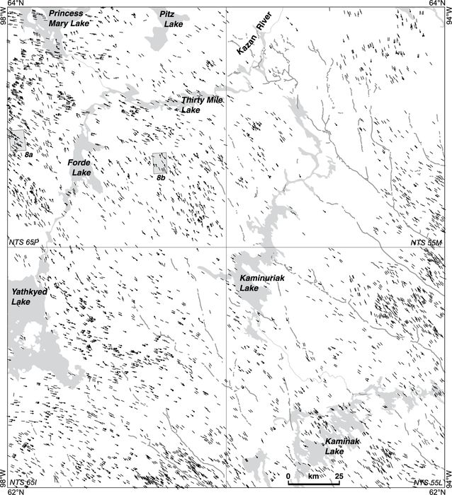
Figure 1

Location map of study area in central Nunavut. The distribution of Thelon Basin and Baker Lake Basin rocks of the Dubawnt Supergroup are shown in dark grey (from Paul et al., 2002).
Carte de localisation de la région à l’étude dans le centre du Nunavut. La distribution des roches des bassins du Thelon et de Baker Lake faisant partie du supergroupe de Dubawnt sont montrées en gris foncé (d’après Paul et al., 2002).
Regional setting
The study area lies near the centre of the area covered by the Late Wisconsinan Laurentide Ice Sheet (LIS) west of Hudson Bay (‘Keewatin Sector’: Prest, 1970). Surficial features in the region (e.g. eskers, ribbed moraine, streamlined landforms) form a distribution pattern that is roughly concentric about a zone mainly characterized by the absence of eskers (Fig. 2). Till is the dominant surficial deposit and occurs as fluted and drumlinized terrain, ribbed moraine and till blankets of varying thickness (1‑20 m). The terrain is rather featureless, consisting of flat-lying to rolling plains with numerous lakes of varying size commonly elongated NW‑SE, parallel to the dominant regional ice-flow direction. Relief is low, rarely exceeding 150 m, with highest elevations at approximately 290 m asl southeast of Princess Mary Lake and 331 m asl between Rankin and Chesterfield Inlets (Fig. 3). The land slopes gently towards Hudson Bay through three sub-drainage basins: Kazan, Lower Thelon and Northwest Central Hudson Bay (Environment Canada, 1986). Flights of raised marine strandlines occur as high as 169 m asl in the Kaminak Lake area but regionally, the marine limit decreases northerly from approximately 161 m around Yathkyed Lake to 130 m west of Pitz Lake, reflecting the distribution of remnant ice within lake basins in the area of the Keewatin Ice Divide (Shilts, 1986). Deglaciation of the area occurred between 7.2 and 6 ka BP (Dyke, 2004).
Figure 2

General location of the Keewatin Ice Divide and distribution of eskers and streamlined landforms in the Keewatin region of central Nunavut (from Aylsworth and Shilts, 1989). Stratigraphic sections discussed in the text are shown with black triangles.
Localisation générale de la ligne de partage glaciaire du Keewatin et distribution des eskers et des formes profilées dans la région du Keewatin au centre du Nunavut (d’après Aylsworth et Shilts, 1989). Les coupes stratigraphiques à l’étude sont représentées par des triangles noirs.
The study area is predominantly underlain by Canadian Shield rocks of the western Churchill Province (Hearne Domain), which comprise Archean gneiss terranes, supracrustal belts and associated plutons, for the most part deformed during the Proterozoic (Paul et al., 2002). Remnants of unmetamorphosed Proterozoic sedimentary and volcanic rocks of the Dubawnt Supergroup outcrop in the most northwestern part of the area (Fig. 1). These rocks are lithologically distinct from the metamorphosed lithologies of the Archean terrane (Gall et al., 1992) and thus are useful as ice-flow indicators.
Figure 3

Digital elevation model within the Keewatin region of central Nunavut. Location of study area is outlined.
Modèle numérique d’élévation pour la région du Keewatin au centre du Nunavut. La région à l’étude est délimitée.
Previous research
Previous regional ice-flow indicator mapping in the area included the measurement of a number of ice-movement erosional features, generally with poorly defined relative chronology, mapping of glacial landforms and lineations interpreted from aerial photographs or satellite imagery, and recognition of glacial dispersal trains at different scales. The following is a summary of literature related to the Quaternary geology of the study area with emphasis on the debate over the duration and location of the Keewatin Ice Divide.
Early interpretations of striations led Tyrrell (1897) to suggest a ‘Keewatin Glacier’ centered in the District of Keewatin that served as one of a number of dispersal centres around Hudson Bay. He proposed three stages in the growth and decline of the ice sheet from centres of outflow shifting progressively to the southeast by up to 400 km. In contrast, Flint (1943) proposed the model of a single ice dome centred over Hudson Bay during the last glacial maximum. In the early 1950s, new field work by the GSC in the ‘barren grounds’ provided a more detailed record of ice-flow indicators in Keewatin (Craig and Fyles, 1960; Lee, 1959; Lord, 1953, Wright, 1967). This work led Lee et al. (1957) to recognize and define the Keewatin Ice Divide as the zone occupied by the last glacial remnants of the Laurentide Ice Sheet west of Hudson Bay. Lee (1959: p. 23) stated “there is no field evidence to indicate that the Keewatin Ice Divide was active during the initial and maximum stages of the Wisconsin glaciation”. Later Prest et al. (1968) summarized the work of Lee and others on the Glacial Map of Canada, showing glacial landforms and cross-cutting striae with undetermined relative ages.
The District of Keewatin was the focus of an extensive drift-prospecting program in the mid‑1970s by the GSC. Ice-movement indicators demonstrating pervasive ice flow towards Hudson Bay and a long dispersal train of red Dubawnt lithologies extending to the Hudson Bay coast was used to infer stability and longevity of the Keewatin Ice Divide (e.g. Shilts et al., 1979; Kaszycki and Shilts, 1979, 1980). Shilts (1980a) argued that the distance of glacial transport and time constraints required to produce the Dubawnt dispersal pattern reflected a sustained southeastward ice flow over the region throughout one or more glacial stades of the Wisconsinan glaciation. Nonetheless, evidence for an earlier southward flow across Keewatin was recognized from striations and southward transport of erratics (e.g. Lord, 1953; Lee, 1959; Shilts, 1973; Cunningham and Shilts, 1977). This was used by Cunningham and Shilts (1977) to suggest a southeastward migration of the ice divide, an idea originally proposed by the pioneering work of Tyrrell (1897). Cunningham and Shilts (1977) also reported late striations indicating northwestward and westward flows northwest of an arcuate zone extending through Forde and Pitz Lake in the northwest part of the study area (“last position of Keewatin Ice Divide” on their Fig. 1, p. 311).
Based on air-photo interpretation, and some ground observation mainly in Keewatin, Aylsworth and Shilts (1989) used a compilation of landforms and materials for the northwestern Canadian Shield to provide a regional interpretation of constructional glacial landforms around the Keewatin Ice Divide (cf. Fig. 2). These authors characterized the divide as a broad area with low-relief hummocky moraine, few streamlined landforms and no dendritic esker systems. They placed the divide in a curvilinear zone extending northeastward in Keewatin, consistent with the 8.4 14C ka Keewatin Ice Divide of Dyke and Prest (1987). In contrast to Dyke and Prest (1987) though, Aylsworth and Shilts (1989: p. 3) reported that “although the dispersal centre had migrated eastward and southward, (...), it probably migrated no more than 100 km”.
Despite the acceptance of the last general position of a divide in the region, refinements of its dynamics have continued. In the 1990s, Boulton and Clark (1990a, 1990b) used satellite imagery over North America to reveal crossing drift lineations, namely in the area of the Keewatin Ice Divide, and to infer mobility of outflow centres within the Laurentide Ice Sheet throughout the last glacial cycles. Based on till composition near Baker Lake, Klassen (1995, 2001) showed strong evidence for southeastward dispersal under the Keewatin Ice Divide area, hence supporting the southeastward migration of the divide. Based on the examination of stratigraphic sections of till along the Kazan River, Klassen (1995) observed differences in provenance related to changes in the location and orientation of the Keewatin Ice Divide, but he also reported that correlations with overburden drill-core information in the area (i.e. Shilts, 1980b) remained unclear. The preservation of “old landforms” in Keewatin revealed from Landsat imagery and aerial photographs was used by Kleman et al. (2002) to infer a cold-based thermal regime and a dome in northern Keewatin during ice sheet build-up. Detailed striation measurements north of Baker Lake led Utting and McMartin (2004) to identify a rotation of the Keewatin Ice Divide from an east-west to a more northeast-southwest orientation. Based on cross-cutting striations and superimposed landforms in the Schultz Lake area, McMartin and Dredge (2005) suggested that much of the glacial landscape at Schultz Lake was related to older flows, older than the Keewatin Ice Divide itself, hence indicating mobile, wet-based ice and a transitory ice divide in the region during the last glaciation.
Methodology
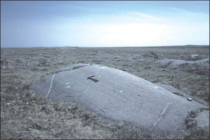
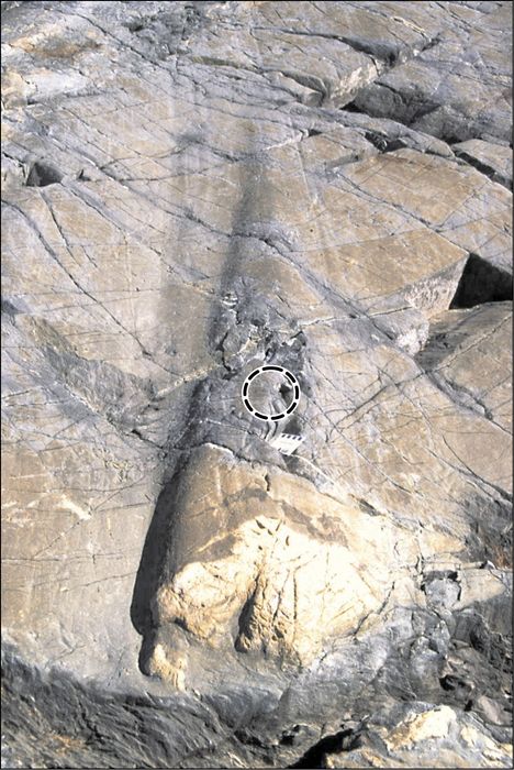
The determination of paleo-ice flow patterns in the study area included the measurement of the orientation of small-scale glacial features on bedrock such as glacial striae and grooves. Field observations were made from over 800 sites in 1997, 1998 and 1999 between latitudes 62° and 64 °N and longitudes 92° and 98 °W. Figure 4 shows a compilation of the detailed striation measurements (small arrows). Summary arrows shown on Figure 4 give a local interpretation of the underlying data in terms of relative age, general direction and spatial continuity (cf. section below). The complete datasets and more detailed maps are available digitally in McMartin and Henderson (2004). Many rock surfaces inscribed with two or more sets of crossing striae were observed, particularly under the area of the former Keewatin Ice Divide (Fig. 5). To unravel the sequence of events, it was imperative to sort out the sense of ice flow and the crosscutting relationships of facets and striae. The sense of flow was determined from crag and tail relationships of various scales, stoss-and-lee topography, crescentic gouges, chattermarks, and roches moutonnées (Fig. 6). Relative ages of striated facets were determined (where possible) by evaluating their relative positions at the outcrop scale (Fig. 7) (cf. Lundqvist, 1990; Stea, 1994).
Existing surficial geology maps for the study area (Arsenault et al., 1981; Aylsworth et al., 1981a, 1981b, 1981c, 1981d, 1984, 1986, 1989) provided an extensive database of subglacial bedforms such as drumlins, flutings and crag-and-tails, and other landform indicators of paleo-flow (i.e. esker, ribbed moraine, etc.). In light of the new erosional observations on bedrock, landforms were systematically re-mapped in 2003 by air-photo interpretation. Previously unrecognized landforms and many cross-cutting and superimposed streamlined landforms were recognized (Fig. 8). These are combined on Figure 9 with all the landforms derived from existing maps.
The study of till stratigraphy in naturally exposed sections was used to provide additional evidence of change in provenance associated with the ice-flow record. One till section exposed along a stream west of Pitz Lake and two multiple-till sections along the Kazan River south of Baker Lake were examined (see Fig. 2 for location). Detailed observations of the three sections were gathered on colour, texture, sorting, structure, lithology, and clast fabric. Samples were collected at about 50 cm intervals for lithologic and geochemical analysis (McMartin and Henderson, 2004).
Sequence of ice flows
The record of successive paleo-ice flows is revealed by cross-striations, lee-side preservation of old striations, and cross-streamlined landforms. It is extensive and complex across the entire region, indicating large-scale patterns of ice-sheet flow and their changes through time. Based on (1) the regional association of striation sets having similar or continuous trends and the same relative age relationships (cf. Fig. 4), and (2) analogous cross-cutting relationships between landforms (if preserved), a sequence of regional glacial flowlines regrouped into ice-flow sets (cf. Clark, 1994) was established for the study area (Fig. 10). Below we present an interpretation of the relative sequence of flow changes in chronological order, from the oldest recognized ice flows thought to have occurred prior to deglaciation, to the most recent flow(s) related specifically to deglaciation of the Keewatin region.
Pre-deglacial ice-flow sets
Southwesterly flows
The earliest flows recognized in the study area are to the southwest (Fig. 10A). The evidence is subtle but found across the entire area with isolated deep striae and grooves trending 209° to 236°. In addition, early south-southwesterly striations (183°‑202°) were measured at a few sites. Early striations indicating a southwest flow have been reported within maps adjacent to the study area (Cunningham and Shilts, 1977; Schau, 1981; McMartin and Dredge, 2005), along the Dubawnt River (Tyrrell, 1897), in the Back River area (Taylor, 1956), and as far north as Wager Bay (McMartin and Dredge, 2005) and perhaps Committee Bay (Little, 2001). Early southwesterly glacial landforms were not observed in the study area although Boulton and Clark (1990a, 1990b) recognized relict southwesterly oriented drift lineations directly north of the area.
Figure 4
A

B
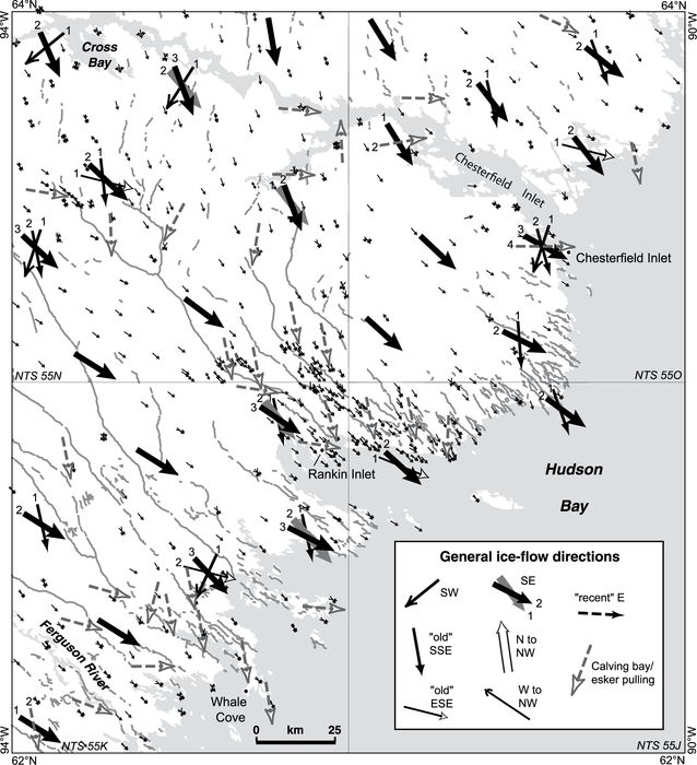
Relative ice-flow sequence determined from the cross-striation record (1 = oldest) of the study area. Large arrows represent the local interpretation of the detailed striation measurements (small arrows) collected recently (n = 814 sites) or reported in previous work (n = 86 sites). The general ice flow directions are grouped by relative ages and spatial continuity. Relative chronology at each outcrop is available in McMartin and Henderson (2004).
Séquence relative de l’écoulement glaciaire dans la région à l’étude déterminée à partir des stries entrecroisées (1 = plus anciennes). Les grandes flèches représentent l’interprétation locale des mesures détaillées des stries (petites flèches) observées récemment (n = 814 sites) ou déjà publiées (n = 86 sites). Les directions générales de l’écoulement glaciaire ont été regroupées par âge relatif et selon leur continuité spatiale. La chronologie relative déterminée à chaque affleurement est disponible dans McMartin et Henderson (2004).
Figure 5
A

B

Beneath the former Keewatin Ice Divide area, ice-flow direction changed almost 180° between phases. Distinctive outcrops were produced. (A) Multi-faceted outcrops forming small trigonal pyramids are common in the Yathkyed Lake area. The pyramidal shape is the result of glacial erosion from three divergent ice-flow directions. Two of the truncated surfaces are commonly well striated. (B) Opposing roches moutonnées indicating ice flow to the WNW and to the ESE on a small island in Thirty Mile Lake. The surfaces bear striae and rat tails of opposite sense on this composite landform.
Sous l’ancienne ligne de partage glaciaire du Keewatin, la direction de l’écoulement glaciaire a varié de presque 180° entre chaque phase d’écoulement. Des affleurements rocheux distinctifs ont été produits. (A) Des affleurements à facettes multiples formant de petites pyramides trigones dans la région du lac Yathkyed. La forme pyramidale résulte de l’érosion glaciaire dans trois directions divergentes. Deux des surfaces tronquées sont généralement bien striées. (B) Roches moutonnées opposées indiquant des écoulements glaciaires vers l’ouest-nord-ouest et l’est-sud-est sur une petite île au lac Thirty Mile. Les surfaces comportent des stries et des queues-de-rat indiquant une direction opposée sur cette forme composite.
There is little indication of southwestward glacial dispersal in central Nunavut, except perhaps Schau (1981) who found some evidence for glacial transport of erratics (<10 km) to the southwest of an outcrop of calc-silicate and marble rocks north of Baker Lake.
South-southeasterly flow
The second oldest event indicates ice flow towards the south-southeast (Fig. 10A). Ice flow during this event is slightly divergent and recorded by early striations and grooves trending 154° to 181°, more pervasive around Kaminak Lake and along Hudson Bay (Fig. 4). This broadly southerly flow was recorded in the region at a few sites (Tyrrell, 1897; Lord, 1953; Lee, 1959), and old southward striations appear occasionally on GSC 1:125 000 scale surficial geology maps covering the area (Arsenault et al., 1981; Aylsworth et al., 1984). Cunningham and Shilts (1977) and McMartin and Dredge (2005) reported early southerly striations in the Baker Lake and Schultz Lake areas. At least a dozen streamlined landforms trending in the same direction as nearby old southerly striations lead us to suggest that some relict bedforms in the study area can be attributed to this ice-flow event. Boulton and Clark (1990a, 1990b) showed early drift lineations oriented south-southeast in the study area.
Evidence for southward glacial transport in the region is not obvious, although Cunningham and Shilts (1977) observed erratics of quartzite of presumed Early Proterozoic age (“Aphebian” in text) around Pitz Lake, which they interpreted to indicate a major period of southward transport from the Schultz Lake area. However, outcrops around Pitz Lake include basal conglomerates of the Thelon Formation (Dubawnt Supergroup) that contain cobble to pebble-size rounded quartzite clasts, originally derived from local quartzite bedrock of both Proterozoic and Archean ages (Hadlari et al., 2004). The dispersal of Dubawnt erratics as far south as the Manitoba border (Shilts et al., 1979) provides a better support for southward glacial transport in the region. Geochemical composition of till collected in the lower parts of drill core south of Pitz Lake also point to an early southward flow (Klassen, 1995).
Easterly flow
The third oldest regional event was east-southeastward (Fig. 10A). Evidence for this parallel flow is regionally extensive but generally less well preserved than the southerly flow. Deep striae and grooves trending 94° to 122° are found at several sites. This flow has never been directly reported in the study area although Nadeau and Schau (1979) observed roches moutonnées and red erratics north of Chesterfield Inlet, providing evidence for a pervasive eastward flow preceding the last south-southeastward flow in that area. It is not certain however whether this eastward flow corresponds in age with the old eastward flow reported here. Although several eastward trending glacial landforms occur in the study area (Fig. 9), we cannot attribute an old age to any of them with confidence. In fact, our observations lead us to ascribe a late deglacial age for most of them (see below). Boulton and Clark (1990a, 1990b) recognized east-southeast trending large-scale drift lineations in the study area and in areas further north, but found no direct evidence for their relative age.
Figure 6
A

B
C
D

(A) Delicate striae preserved on mafic volcanic rocks south of Yathkyed Lake. The sense of flow (northward; to the upper right of photo) is derived from miniature whaleback forms. (B) Roche moutonnée indicating ice flow towards the SE (to the upper left of photo) in the Rankin Inlet area. (C) Large rat tail indicating ice flow towards the SE (top of photo) south of Rankin Inlet. Scale is 7 cm long. (D) Deep striae, gouges and crescentic fractures north of Kaminak Lake indicating ice flow towards the SE (top of photo).
(A) Stries fines préservées sur des roches volcaniques mafiques au sud du lac Yathkyed. Le sens de l’écoulement (vers le nord; coin supérieur droit de la photo) est déterminé à partir de petites formes en dos de baleine. (B) Roche moutonnée indiquant un écoulement glaciaire vers le sud-est (coin supérieur gauche de la photo) dans la région de Rankin Inlet. (C) Grande queue-de-rat indiquant un écoulement glaciaire vers le sud-est (haut de la photo) au sud de Rankin Inlet. L’échelle fait 7 cm de long. (D) Stries profondes, broutures et marques en croissant au nord du lac Kaminak indiquant un écoulement glaciaire vers le sud-est (haut de la photo).
Figure 7
A

B

(A) Opposing sets of striations south of Kaminuriak Lake. Deep striae and small crag-and-tails in bedrock indicating ice flow towards the NNW (1) are preserved on the lee surface (south) of an outcrop noticeably striated to the SE (2), creating a bevelled facet. (B) Sets of striations preserved on a large island south of Rankin Inlet. Deep striae and grooves indicating ice flow towards the SE (1) are preserved on the gently sloping lee-side of surfaces striated towards the ESE (2). This relationship is thought to reflect late glacial ice flow associated with lobate ice-front positions.
(A) Stries opposées au sud du lac Kaminuriak. Des stries profondes et de petits crag-and-tails rocheux indiquant un écoulement glaciaire vers le nord-nord-ouest (1) sont préservés sur la surface aval (sud) d’un affleurement manifestement strié vers le sud-est (2), formant ainsi une facette biseautée. (B) Stries préservées sur une grande île au sud de Rankin Inlet. Des stries profondes et des cannelures indiquant un écoulement glaciaire vers le sud-est (1) sont préservées sur la pente descendante du côté aval de surfaces striées vers l’est-sud-est (2). On pense que cette relation reflète un écoulement glaciaire tardif associé à des positions lobées de la marge glaciaire.
Till stratigraphy along the Kazan River led Klassen (1995) to suggest an early eastward flow in the region (Lower till at his section KC, p. 50). Examination of two Kazan River sections (KR‑A and KR‑B) indicates at least three distinctive till units, of which the lowest till is thought to have a provenance from the west (McMartin and Henderson, 2004). At section KR‑A, the lowest till (unit D) is separated from the overlying unit by stratified sediments and a sharp colour change (Fig. 11). The relative proportion of Dubawnt clasts is high in relation to greenstone/plutonic lithologies, and several base metal concentrations are low in that unit (e.g. Pb, Zn), suggesting transport over Dubawnt lithologies and, hence, an easterly direction of glacial transport. Clast fabrics in this unit are weak but the relative chronology interpreted from striations measured on outcrop exposed across the river is consistent with an early eastward flow (Fig. 11).
Southeasterly flows
Evidence for old (i.e. pre-deglacial) southeasterly flows occurs sporadically over much of the area, mainly in the striation record (Fig. 4, SE(1)). These older flows are divided here in two sets on the basis of their relative age relationship with northerly flows (described below): (1) southeast flows pre-dating northerly flows, occurring north of Kazan River (Fig. 10A, SE(1)), and (2) southeast flows post-dating northerly flows, recognized essentially south of Kazan River (Fig. 10A, SE(2)), and only differentiated from later convergent southeasterly flows when occurring at significantly different directions (cf. Fig. 10B).
The first set is indicated by old striations trending 125° to 144°, commonly superimposed by north to northwesterly striations (Fig. 10A). Well developed crag-and-tails that can be associated with this early southeastward flow occur mainly between Princess Mary Lake and Pitz Lake, and the composition of till and underlying striations on bedrock at section 30M‑A west of Pitz Lake suggest it was a pervasive erosional ice-flow event (McMartin and Henderson, 2004). North of Pitz Lake, ancient southeasterly trending striations and relict crag-and-tail landforms observed as far north as Schultz Lake attest to the extent of this paleo-ice flow (Cunningham and Shilts, 1977; McMartin and Dredge, 2005).
The second set indicates a nearly parallel flow with striations, grooves and rare roches moutonnées trending 134° to 145°, crosscutting northerly striations (Fig. 10A). At several sites in the Yathkyed Lake area, two or three sets of striations record a progressive counter-clockwise shift from southeastward to eastward, indicating this old southeastward set is closely linked in age with the deglacial convergent ice flows (see below). Indeed, this sequence is reversed in the Chesterfield Inlet area, where the striation record indicates a clockwise shift from southeastward to a more southerly direction.
The principal direction of glacial transport in surface till across the study area is southeastward (Shilts, 1973; Ridler and Shilts, 1974; DiLabio, 1979; Shilts et al., 1979; Coker et al., 1992; Henderson, 2000; Klassen, 1995, 2001; McMartin, 2000; McMartin et al., 2003a). Although few till provenance studies were completed west of Kazan River, glacial transport in directions other than southeastward was shown to be limited in the Pitz Lake area (Klassen, 1995). Moreover, glacial stratigraphy along the Kazan River east of Pitz Lake indicates that surface till was largely deposited by ice flow to the southeast, presumably during this event (Klassen, 1995). Likewise, at both sections along the Kazan River (KR‑A and KR‑B), the two upper tills (units A and B) have a relatively low percentage of Dubawnt lithologies, a high percentage of greenstone/ plutonic lithologies, and high base metal concentrations, compared to lower diamicton unit(s) (Fig. 11). This composition indicates a provenance in the crystalline terrane outcropping north of the two sites. Till fabrics at both sections vary in strength, but suggest southeasterly (unit B) and south-southeasterly (upper till – unit A) ice flows (McMartin and Henderson, 2004).
Northerly flows
A regional-scale flow reversal is recognized in the western portion of the study area with persistent north to north-northwestward erosional ice-flow indicators (334°‑006°) (e.g. Fig. 6A), as far east as Kaminuriak Lake (Fig. 10A). In the same area, numerous outcrops are moulded in two opposite directions, sometimes three, forming small trigonal pyramids (Fig. 5A). North-northwesterly striations are commonly found protected on lee-side surfaces of outcrops glacially moulded to the southeast (cf. Fig. 7A), indicating they pre-date the latest southeasterly flows south of Kazan River. Scattered old northward striations were reported earlier in the Yathkyed Lake area by Tyrrell (1897), Lord (1953) and Coker et al. (1992), and they are abundant in the entire Schultz Lake map area to the north (McMartin and Dredge, 2005). Streamlined landforms that can be associated with this north-northwesterly flow are abundant in the western part of the study area (Fig. 9). They form large relict drumlins and crag-and-tails, occasionally superimposed or crosscutted by more recent landforms (Fig. 8A). Locally, north and west of Kazan River, there is evidence that the north-northwestward flow later shifted to the northwest (317°‑334°), as indicated by cross-striations and cross-streamlined landforms (Fig. 10A). A similar counter-clockwise rotation in ice-flow trends was reported north of the study area (Utting and McMartin, 2004; McMartin and Dredge, 2005).
Evidence for northward glacial transport is indicated by the presence of distinctive Proterozoic dolomite boulders over the Yathkyed greenstone belt derived from Hurwitz Group outcrops to the south (McMartin and Henderson, 1999). In Section KR‑A, a thin diamicton unit (unit C) shows a marked increase in total Dubawnt clasts, specifically in arkosic sandstone (McMartin and Henderson, 2004), indicative of a very local provenance (Fig. 11). This, together with the clast fabric, suggests this unit was likely deposited during a northerly ice-flow event. Compelling evidence for northward dispersal was also recently found in the Schultz Lake map area to the north with the distribution of Thelon sandstone and dispersal of Dubawnt volcanic clasts from the Baker Lake Basin (McMartin et al., 2006).
Deglacial ice-flow sets
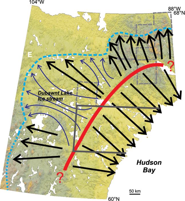
Dubawnt Lake ice stream flow
A highly convergent flow pattern of late striations and streamlined landforms trending west to northwest occurs in the northwestern portion of the study area (Fig. 10B). The flow pattern extends back to the Keewatin Ice Divide area, and slightly beyond (cf. Fig. 2). Striations trending 270°‑326° in this area are superimposed on all of the other flow-sets described above, indicating that the convergent flow represents the last major active flow in this area. Associated westerly to northwesterly-trending short and/or narrow drumlinoid features are commonly superimposed on large drumlins and crag-and-tail landforms indicative of northward flow (Fig. 8A). This flow set is only post-dated south of Kazan River and around Yathkyed Lake by deglacial southeasterly flows, and locally by an opposite easterly flow near Pitz Lake (see below). McMartin and Dredge (2005) mapped the abrupt northern limit of the westerly ice-flow indicators immediately south of Schultz Lake. We believe this ice-flow pattern is part of the convergent onset zone of the Dubawnt Lake ice stream that extends westerly into the higher portions of the Thelon River basin as far as longitude 106 °W (Stokes and Clark, 2003). These authors suggested the ice stream operated during deglaciation 9‑8.2 ka BP and that the ice-stream lineaments were produced isochronously, providing a snapshot view of the ice-stream bed immediately prior to shut-down. Although there is currently no evidence for glacial transport in a westerly to northwesterly direction in the northwest part of the study area, current work on till provenance in the Schultz Lake area suggests some westerly dispersal from the Baker Lake Basin (McMartin et al., 2006).
Figure 8
A

B
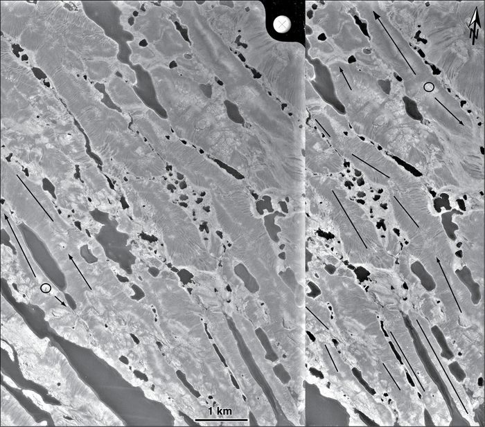
Stereograms of intersecting streamlined landforms in the area of the former Keewatin Ice Divide (within NTS 65P, see Fig. 9 for location). (A) West of Forde Lake, large drumlins indicative of northward ice flow are superimposed by flutings and crag-and-tails formed by the northwestward convergent flow of the Dubawnt Lake ice stream. (B) Intersecting landforms indicating nearly opposite flows south of Kazan River. Opposing crag-and-tails originate from the same crag (shown as a circle) at several sites. Although landforms associated with the north-northwestward flow are best preserved, the relative age of striations measured on nearby outcrops suggests that southeastward flow was last in this area. Arrows represent crag-and-tails and straight lines represent other glacial lineations in till. (Source: Aerial photographs A14887 85‑86 (A) and A14703 7‑8 (B); National Air Photo Library, 1955, 1:58 000 scale).
Stéréogrammes de formes profilées entrecroisées dans la région de l’ancienne ligne de partage glaciaire du Keewatin (à l’intérieur de SNRC 65P, voir Fig. 9 pour la localisation). (A) À l’ouest du lac Forde, de longs drumlins indiquant un écoulement glaciaire vers le nord sont superposés par du till cannelé et des crag-and-tails formés par un écoulement glaciaire convergent vers le nord-ouest faisant partie du courant glaciaire du lac Dubawnt. (B) Formes du relief entrecroisées indiquant des écoulements opposés au sud de la rivière Kazan. Des crag-and-tails opposés émanent du même nez rocheux (montré par un cercle) à plusieurs endroits. Même si les formes du relief associées à l’écoulement vers le nord-ouest sont les mieux préservées, l’âge relatif de stries mesurées sur des affleurements adjacents suggère que l’écoulement vers le sud-est était le plus récent dans cette région. Les flèches représentent les crag-and-tails et les lignes droites les autres linéaments glaciaires dans le till. (Source : Photographies aériennes A14887 85‑86 (A) et A14703 7‑8 (B); Photothèque nationale de l’air, 1955, échelle 1:58 000).
Local easterly flow
Late striations trending 88°‑111° and streamlined landforms indicative of an easterly flow are found locally on either side of Thirty Mile Lake and west of Pitz Lake (Fig. 10B). Below a 6 m high till section immediately south of Pitz Lake, striae, crescentic fractures and stoss-and-lee microtopography indicate an easterly flow (McMartin and Henderson, 2004). At two sites 20 km north of Pitz Lake, well defined, late easterly striations were found on glacially shaped outcrops (McMartin and Dredge, 2005). These ice-flow indicators are opposite to and post-date the Dubawnt Lake ice stream set (cf. Fig. 5B), indicating a late inversion of ice flow within a local remnant ice mass.
Southeasterly convergent flows
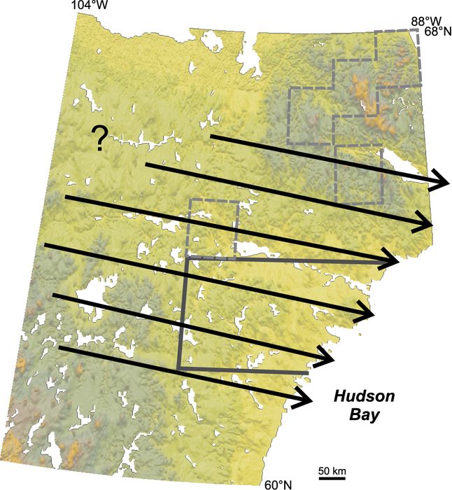
Over most of the study area (essentially southeast of Kazan River and Pitz Lake), dominant striations, grooves and roches moutonnées range from eastward to southward (95°‑178°) (Fig. 4, SE(2); Fig. 6B‑D), indicative of convergent ice flows to the southeast from the Keewatin Ice Divide area (Fig. 10B). Streamlined landforms follow this regional trend and occur over much of the area (Fig. 9), except within a central linear zone over the Kaminuriak Lake basin, and on either side of Chesterfield Inlet where drift is thin and bedrock is principally composed of coarse-grained orthogneisses (Paul et al., 2002). Convergence of flowlines is presumed to be a result of ice divide geometry and reflects the arcuate configuration of the last position of the divide in this area (i.e. concave towards Hudson Bay). Although the flowlines are depicted as a continuous flow set on Figure 10B and thereby assumed to be part of one population, we find strong evidence suggesting they formed time-transgressively as the ice front retreated.
Figure 9
A
B

Map of streamlined landforms (drumlins, flutings and crag-and-tails) compiled from existing surficial maps (n = 3 900) or recently interpreted from aerial photographs (n = 4 401) of the study area (modified after McMartin and Henderson, 2004). Small boxes in NTS 65P indicate the location of Figures 8A and 8B.
Carte des formes profilées (drumlins, flûtes et crag-and-tails) compilées à partir des cartes de la géologie de surface existantes ou récemment interprétées à l’aide de photographies aériennes de la région d’étude (tiré de McMartin et Henderson, 2004). Les boîtes dans le secteur NTS 65P montrent l’emplacement des figures 8A et 8B.
Figure 10
A

B

Summary of ice-flow patterns in study area and corresponding ice-flow directions derived from both the erosional and depositional records. (A) Pre-deglacial ice-flow sets in chronological order and direction of glacial flow. (B) Deglacial ice-flow sets, and late deglacial ice flows related to pulling towards esker tunnels or calving bays.
Synthèse des patrons d’écoulements glaciaires dans la région à l’étude et directions associées de l’écoulement dérivées à la fois des indices d’érosion et des formes de déposition. (A) Familles d’écoulement glaciaire antérieur au retrait glaciaire, en ordre chronologique et selon la direction de l’écoulement. (B) Familles d’écoulement glaciaire reliées au retrait glaciaire ainsi que les écoulements glaciaires tardifs reliés à l’appel de la glace vers les tunnels d’esker ou vers des baies de vêlage.
The patterns of ice-flow features appear disjointed in many areas, show cross-cutting of bedforms and are not consistently parallel (Fig. 9), indicative of a time-transgressive imprint that is continuously reorganized during margin retreat (cf. Clark, 1999). Further evidence is provided by superimposed DeGeer moraines at oblique angles to the well-preserved streamlined landforms, suggesting retreat direction was not always parallel to the regional direction of ice flow. In a number of these areas, streamlined landforms are also reoriented obliquely to the regional southeastward ice-flow direction, either to the east-southeast or to the south-southeast (cf. Fig. 9), producing a complex pattern of ice-flow patterns that can be easily confused without regional mapping and field work. Late deglacial striations associated with lobate ice front positions in contact with marine waters are found in several areas below about 100 m asl, namely where marine calving bays probably moved up Rankin Inlet and Chesterfield Inlet (Fig. 10B). Moreover, near large continuous eskers (<3‑4 km on either side), the latest striations can be found at pronounced angles to the esker ridge, suggesting lateral movements of ice towards the esker tunnel (Fig. 10B; cf. Repo, 1954).
Paleo-ice flow history
We have presented above a relative chronology for the ice-flow sets and assigned most of them a pre-deglacial age. The Dubawnt ice-stream flow, and the time-transgressive convergent flows into Hudson Bay, are clearly believed to be deglacial flows. Because we have no indication of the absolute ages of the other ice-flow sets, it is not clear if the pre-deglacial flows were formed entirely during the Wisconsinan glacial period or whether they include palimpsests of earlier glaciations. In conjunction with geological data gathered in surrounding areas and work in progress, we now group the ice-flow sets into phases of ice flow for the Keewatin region, propose ice divide positions, and compare them with existing ice-sheet reconstruction models (Fig. 12).
Figure 11

Lithological and geochemical composition of till at section KR‑A along the Kazan River (see Figure 2 for location) (modified after McMartin and Henderson, 2004). Contour Schmidt equal-area nets (lower hemisphere) show clast orientations. The mean vector (V1), the strength of the principle eigenvector (S1) and the number of measurements (N) are indicated. Striations measured on bedrock exposed across the river from the section are also shown (1 = oldest).
Composition lithologique et géochimique du till à la coupe KR‑A le long de la rivière Kazan (voir figure 2 pour la localisation) (d’après McMartin et Henderson, 2004). Les stéréonets de Schmidt à aire égale (hémisphère sud) montrent l’orientation des cailloux. Le vecteur moyen (V1), la force du vecteur caratéristique (S1) et le nombre d’observations (N) sont indiqués. Les stries mesurées sur un affleurement rocheux situé de l’autre côté de la rivière en face de la coupe sont aussi représentées (1 = plus anciennes).
Phase A
Early flows to the southwest across Keewatin, and perhaps as far north as Committee Bay, may have dispersed from a centre located northeast of the study area within mainland Nunavut, or farther north, maybe as far as Foxe Basin (Fig. 12). Boulton and Clark (1990b) suggest an early outflow centre in northeast Keewatin or northern Baffin Island, which agrees with the old southwestward flow presented here. These authors tentatively attribute southwesterly oriented drift lineations to the earliest Wisconsinan ice-sheet expansion (Flow stage A, p. 338). Likewise, Kleman et al. (2002) place an outflow centre over Baffin Island and the Melville and Boothia peninsulas, expanding into Keewatin at 90‑84 ka BP. Given that the position of the ice divide during Phase A is considerably different than that proposed for following phases, it seems probable that Phase A predates the last glacial maximum (LGM), and occurred during the Early-Mid Wisconsinan, or during a previous glaciation.
Phase B
Phase B reflects a major southern expansion of ice across the study area, and is presumably responsible for the presence of Dubawnt erratics in till of Northern Manitoba. The northern extent of the southerly flows lies immediately north of Schultz Lake, east of Tehek Lake and across Wager Bay (Cunningham and Shilts, 1977; McMartin and Dredge, 2005). Pervasive, opposite, early northward erosional forms and glacial dispersal have been observed west of Committee Bay to the north (Phase I, McMartin et al., 2003b). If these opposite flows were contemporaneous, we believe a dispersal centre or major ice divide may have been positioned in Keewatin, between the study area and Committee Bay, and across Wager Bay (Fig. 12). Based on the robust nature of northward ice-flow indicators (i.e. roches moutonnées and bedrock flutings), their consistent direction over large areas, and their good preservation at high elevations, Little (2001) and McMartin et al. (2003b) assigned a LGM timing for this northward phase west of Committee Bay. Kleman et al. (2002) positioned a dome in northern Keewatin by 73 ka BP based on old southerly striations (Tyrrell, 1897; Lee, 1959) and till lineations. Similarly, Boulton and Clark (1990b) assigned an Early Wisconsinan age for south-southeasterly flows from an early ice divide trending north-south in northern Keewatin (Flow Stage B, p. 338). Without any evidence for relative ages, these authors assigned a later age for early, opposite northerly lineations (Flow set 5, Stage C1, p. 338). We argue that the opposite spatial relationship between old southerly flows in the study area and the northerly flows close to and north of Wager Bay suggests these flows were part of the same phase, yet of uncertain age. If the ice divide position we propose in Keewatin during this Phase is valid, then it represents a southwestward movement of the ice divide by a minimum of 300 km.
Figure 12
A

B

C
D

E

F
G

Phases of ice flow in central mainland Nunavut reconstructed from pre-deglacial and deglacial ice-flow sets (cf. Fig. 10) and from available data in surrounding areas, and their relative age relationships. Proposed locations of ice divide positions are approximate. Dashed flow lines are presumed relict, yet unrecognized in the literature. Ice stream flows are shown in blue. Ice marginal positions (dotted blue line) for Phases E (8.5 ka BP), F (8 ka BP) and G (7 ka BP) are from Dyke (2004). Study area is outlined, as well as areas covered by recent GSC Quaternary mapping projects (dashed boxes).
Phases de l’écoulement glaciaire au centre du Nunavut continental reconstituées à partir des familles d’écoulement glaciaire antérieur et postérieur au retrait glaciaire (cf. fig. 10), et leur âge relatif. La localisation de l’emplacement des lignes de partage glaciaire est approximative. Les lignes d’écoulement tiretées sont présumées reliques, mais elles ne sont pas encore documentées dans la littérature. Les lignes d’écoulement associées à des courants de glace sont représentées en bleu. L’emplacement de la marge glaciaire (ligne pointillée bleue) pour les phases E (8.5 ka BP), F (8 ka BP) et G (7 ka BP) sont tirées de Dyke (2004). La région à l’étude est délimitée ainsi que les régions récemment étudiées par la Commission géologique du Canada à travers des projets de cartographie du Quaternaire (boîtes tiretées).
Phase C
This Phase represents an early advance of ice into the region from an undetermined position in the Northwest Territories (Fig. 12). If the eastward lineations regrouped into Flow set 10 of Boulton and Clark (1990b) are of the same age, then it probably extended across the Back River Basin. In addition, old eastward striations were found recently in the higher Thelon River Basin as far west as longitude 104° (Hardy, personal communication, 2004). This phase may be responsible for the observation of scattered Dubwant erratics and red till northeast of the Dubawnt dispersal train that straddles the study area (Nadeau and Schau, 1979; McMartin, 2000). Perhaps in parts of the Dubawnt train, the apparent direction of southeastward dispersal also results from the effects of southward dispersal reworked easterly. Dyke et al. (1982) and Dyke and Prest (1987) proposed an ice dome west of the study area (>500 km) during LGM with associated east-southeastward flow lines, and postulated its eastward migration into Keewatin from 12 to 9 ka BP. If the zone of maximum erosion is expected to move outward when an ice sheet achieves maximum thickness (i.e. Boulton, 1996), then the faded nature of the associated eastward ice-flow indicators does uphold the hypothesis that this phase is of LGM age. Alternatively, it may have occurred during ice-sheet build-up prior to LGM, or as the ice sheet retreated after LGM.
Phase D
The strong evidence for southeastward glacial transport in the study area, in particular across the central axis of the Keewatin Ice Divide (Zone 1 of Aylsworth and Shilts, 1989), as well as the ubiquitous southeastward erosional ice-flow indicators, suggests Phase D was a major erosional phase in the Keewatin region. Southeast flow must have been from a divide first located northwest of the final position of the Keewatin Ice Divide in order to bring Dubawnt clasts from the Baker Lake Basin into the entire study area (Fig. 12), an idea first proposed by Kaszycki and Shilts (1980, Keewatin Ice Divide position 3, Fig. 6), and later by Klassen (1995) to explain the composition of surficial deposits in the Pitz Lake area. The position of the divide in Figure 12 is constrained by the lack of evidence for southward transport of distinctive carbonate erratics in surface till from a small Paleozoic outlier west of Schultz Lake (Aylsworth and Shilts, 1989), by the up-ice limits of striations in the Schultz Lake area, and by opposite directions of ice-flow indicators within a narrow zone west of Wager Bay (McMartin and Dredge, 2005). The western-most position of the divide is not known although Boulton and Clark (1990b) placed a divide with converging southeastward flows about 250 km northwest of the position we propose here (Flow Stage D, p. 338). The question of where streamlined landforms begin under an ice divide produces the main difference between the two ice divide positions. In addition, Boulton and Clark (1990b) used a group of ‘south-southeast’ lineations north of Tehek Lake to gather their ice divide position whereas detailed field work in this area clearly indicates a north-northwestward ice flow (Utting and McMartin, 2004). Besides, as discussed earlier, we believe the convergent southeastward flows occurred much later during deglaciation. The age of Phase D is not known, though it may coincide with LGM or shortly after.
Phase E
Phase E indicates a major reversal of flow in the western part of the study area as the ice divide migrated towards the southeast by as much as 250 km from its last position in Phase D (Fig. 12). The migration appears to have resulted from the clockwise rotation of the divide to a more NNE‑SSW position, with the centre point stable in the uplands south of Wager Bay as indicated by McMartin and Dredge (2005). This flow is significant in that it implies that a zone of outflow existed in the Kaminak-Kaminuriak Lakes area, southeast of the last position of the Keewatin Ice Divide, and prior to the latest southeastward flows in that area. Based on northward flowing indicators measured along the northern shore of Yathkyed Lake, Tyrrell (1897) defined the latest position of a centre of outflow southeast of Yathkyed Lake during deglaciation. In fact, this is probably the first phase that shows evidence for deglaciation, at least for regions to the north of the study area. As suggested by Boulton and Clark (1990a), the southeast shift in the position of the divide conceivably reflects the progressive drawdown associated with development of flow through Hudson Strait, and/or was triggered by the inception of the Dubawnt Lake ice stream (their Flow Stage G1).
Near Tehek Lake, the latest flow is more northerly (Utting and McMartin, 2004), and may represent the head of an ice stream flowing northwestward in the Back River basin (Fig. 12), perhaps forming a lobe in Queen Maud Golf at 8.5 ka BP (Dyke, 2004). A northeastward ice flow into paleo-Committee Bay (Phase II, McMartin et al., 2003b) may have been operating during this phase as the ice front retreated and formed a calving bay in that area (9‑8.5 ka BP, Dyke, 2004).
Phase F
Between Phase E and this phase, the ice retreated to the Chantrey Moraine System and the McAlpine Moraine at 8.2 ka BP (Dyke, 2004). The Dubawnt Lake ice stream was operating in the Thelon River valley (Stokes and Clark, 2003), extending back to areas close to the ice divide. After 8.2 ka BP, the ice stream shut down, the ice front continued to retreat easterly, and the ice divide probably began to migrate back to the northwest as shown on Figure 12 at Phase F. North of Wager Bay, the ice flow became more northerly, perpendicular to an ice front that is oriented into a general east-west configuration (Phase III, McMartin et al., 2003b). South of the divide, the southeastward flow commenced to become convergent as a result of marine drawdown into a rapidly retreating calving front in Hudson Bay (8‑7.7 ka BP, Dyke, 2004). Deglaciation occurred over large areas in contact with deep lakes or marine waters, producing a lobate ice sheet with streamlined landforms fanning out to arcuate end moraines. Boulton and Clark (1990a, 1990b) assumed the convergent southeasterly-trending drift lineations in the area were middle Wisconsinan in age, therefore occurring much before the Dubawnt Lake ice stream. We showed evidence that the convergent southeasterly ice flows operated time-transgressively as deglaciation proceeded across Keewatin.
Phase G
Between about 8 and 7 ka BP, the ice front retreated significantly as the marine calving bay moved up rapidly into Hudson Bay, leading to the splitting of the ice sheet in two masses on either side of Hudson Strait (Dyke, 2004). The final position of the ice divide depicted on Figure 12 at Phase G lies across Yathkyed Lake, Pitz Lake, the western part of Baker Lake, and over the uplands south of Wager Bay. It indicates a northwestward shift of about 100 km from the position at Phase E. In the study area and within the Schultz Lake map sheet to the north, the ice divide position is constrained by the limit of late southeastward ice-flow indicators. This is the position that has been shown in previous maps and reports (Cunningham and Shilts, 1977; Shilts et al., 1979; Shilts, 1980a; Aylsworth and Shilts, 1989) as the location of the Keewatin Ice Divide sensu stricto. After 7 ka BP, the remaining ice mass, covering basically the Keewatin Ice Divide Zone 1 of Aylsworth and Shilts (1989), is further split in two small masses on either side of Chesterfield Inlet as the sea invades the Thelon River valley before final deglaciation after 6.5 ka BP (Dyke, 2004).
Significance of relict glacial landscape beneath the Keewatin Ice Divide
The widespread preservation of crosscutting glacial erosional forms (striae, grooves, roches moutonnées, etc.) and ice-moulded landforms in central Nunavut reflects a sequence of regional ice-flow events of different directions at different times. This study shows that the most recent ice-flow events have not destroyed all evidence of previous ice-flow directions, particularly in the glacial erosional record. As many as five discrete orientations of striations are preserved at several sites in the area close to the Keewatin Ice Divide (cf. Zone 1 of Aylsworth and Shilts, 1989). The profusion of opposed and superimposed streamlined forms beneath the former ice divide is indicative of ice flowing from considerably different directions, distinct from those associated with the last position of the Keewatin Ice Divide. Aylsworth and Shilts (1989) suggested the constructional landforms within and around the former ice divide were related to ice flowing from the divide during much of the last glaciation. Alternatively, we believe that much of the glacial landscape under the former Keewatin Ice Divide relates to older flows, and that the coexistence of ice directional indicators of different orientation throughout the study area reflects the transitory nature of ice divide(s) in the region.
Given that horizontal ice velocity, and therefore glacial erosion, is minimal under ice divides (e.g. Benn and Evans, 1998), it has been suggested that deformation of landforms by multiple flows can only occur at some distance from an ice divide (Clark, 1993). Close to or beneath the former Keewatin Ice Divide, within a zone of a minimum of 150 km in width, we find evidence for a range of subglacial modification of landforms from the intact survival of pre-existing landforms, to superimposed landforms, to strong deformation where the most recent lineations become dominant. With increasing distance from this zone, the landforms predominantly reflect the last ice-flow patterns and only isolated relict bedforms are found, unless the abundant ribbed moraines in this area are interpreted as the result of crossing drift lineations (e.g. Boulton, 1987). If we follow Clark’s argument that the ice-flow velocity may be the main determinant of the degree of deformation, then the observed continuum of landforms indicates significant changes in flow velocity that can only be obtained by migrating ice divide(s).
Boulton and Clark (1990a, 1990b) suggested that areas covered by the Laurentide Ice Sheet with a large number of glacial lineations reflect less intense glacial erosion and debris transport, and correspond to general locations of migrating ice divides. In the study area, the complex record of small-scale erosional forms and the evidence for attenuated opposing ice-flow indicators, along with relict landforms and relict deposits, imply that both erosion and deposition were occurring at various times during glaciation. While Kaszycki and Shilts (1980) also envisioned the idea of alternating erosion-deposition under active ice, they did not invoke significant changes in the position of ice divides and flow patterns. In the Keewatin region, the major shifts observed in ice-flow directions, the multiple-till stratigraphy along the Kazan and Thelon Rivers, and patterns of glacial dispersal to some extent, are compatible with proximity to a migrating ice divide, and suggest there was a major input of subglacial sediment for some of the ice-flow events, while for others there was probably no input but only minor erosion/deformation of existing surfaces. On the other hand, shifts in ice flow were probably occurring too rapidly for total reorganisation of the bed, or for a gradual change in the direction of ice flow. Rapid shifts in ice flow separated by periods of relative stability could explain the occurrence of ice-flow indicators in discrete sets (e.g. Clark, 1993).
Boulton and Clark (1990a, 1990b) also suggested that the basal zone of little or no basal flow can be up to 200 km wide under dispersal centres and that no significant glacial lineations can occur in this zone. For that reason they proposed that the appearance of the Keewatin Ice Divide was a bogus feature produced by the use of lineations of different ages to define the divide, and by the migration of the divide (Boulton and Clark, 1990a; Fig. 16). Alternatively, we suggest that the absence of eskers over the divide zone and the radial pattern of eskers and ribbed moraine around the Keewatin Ice Divide strongly argues against a false ice divide position. Moreover, similar to that reported in contemporary ice sheets near ice divides (i.e. Wilch and Hughes, 2000), flowlines probably extended nearly to the ice drainage divide, as recorded by striation limits and to some extent by corresponding landforms. Although basal shear stresses are known to be small near ice divides, Pettit et al. (2003) recently suggested longitudinal stresses (pulling effect of down-stream ice) in present-day warm-based ice can be significant and can control basal sliding velocity in these areas. Therefore, although we observed old glacial landforms preserved beneath the divide zone, we argue that the Keewatin Ice Divide Zone 1 of Aylsworth and Shilts (1989) is a reasonable approximation of the last position of the central axis of the divide, as opposed to the “general position throughout the last glaciation” (Aylsworth and Shilts, 1989: p. 3).
Summary
An ice-flow sequence was reconstructed in the Keewatin region of central Nunavut through the careful mapping and correspondence over broad areas of striae and glacial landforms. The sequence of paleo-ice flows presented herein shows that a zone of outflow within the Laurentide Ice Sheet existed in Keewatin, possibly through much of its Wisconsinan history, as originally proposed by Tyrrell (1897) and later by Shilts (1980a). Nonetheless, the observation of multi-faceted and cross-striated outcrops, palimpsest streamlined landforms and stacked tills of distinct provenance in the study area indicates shifting ice-flow centres, where relatively slight shifts in either the configuration or location of the zone of outflow, or both, produced drastic changes in ice-flow directions.
The record of successive flows suggests that a divide shifted several times in different directions in Keewatin, by as much as 500 km between phases, prior to the final decay of the LIS towards its last position. Earlier imprints of glacial flow were modified and overprinted by the younger ice-flow patterns but the patterns of cross-cutting ice-flow sets document the evolving geometry of the ice sheet that generated them. The relict glacial landscape underneath the Keewatin Ice Divide Zone 1 of Aylsworth and Shilts (1989) reflects protection under the ice divide because of low-velocity basal sliding, and changes in flow velocity as a result of ice divide migration.
A sequence of seven distinct regional phases of ice flow was established in the Keewatin region from Phase A, which probably occurred prior to LGM, during the Early Wisconsinan or perhaps prior to the last glaciation, to Phase G before final deglaciation. Flows during Phases A and C were probably from ice centres external to the region. The others stemmed from local ice centres and divides in central Nunavut, and particularly from the Keewatin Ice Divide area from Phase D through deglaciation. The discordances in flow direction during the last deglacial flows into Hudson Bay suggest the convergent southeasterly flows continuously operated during margin retreat.
This work argues against a stable Keewatin Ice Divide throughout the Wisconsinan glaciation, and lays the foundation for a new and revised glacial history for the Keewatin Sector of the Laurentide Ice Sheet. The work also questions previous interpretations of large erratic dispersal patterns, such as the Dubawnt dispersal train, and provides a framework for understanding glacial dispersal trains from mineralized bedrock, and, consequently, has important implications for mineral exploration in the Keewatin region.
Parties annexes
Ackowledgements
This work was carried out as part of the Western Churchill NATMAP Program in 1997‑2002, and the Western Churchill Metallogeny Project (Y12‑NR4550) under the Northern Resources Development Program of Natural Resources Canada (http://nrd.nrcan.gc.ca). We are grateful to S. Khan, W. Carter and C. St-Pierre for assistance in the field, and to the GSC and INAC bedrock mapping groups for sharing logistics and mapping expertise in 1997, 1998 and 1999 (S. Hanmer, D. Irwin, R. Rainbird, C. Relf and S. Tella). The authors would also like to acknowledge Polar Continental Shelf Project for providing invaluable helicopter support. Thanks are extended to Tracy Barry for preparing some of the figures, and to Lynda Dredge and two anonymous reviewers for useful comments on an earlier draft of the manuscript.
Note
-
[*]
Geological Survey of Canada contribution number 2005281
References
- Andrews, J.T., 1987. The Late Wisconsinan glaciation and deglaciation of the Laurentide Ice Sheet, p. 12‑37. In W.F. Ruddiman and H.E. Wright Jr., eds., North America and Adjacent Oceans During the Last Deglaciation, Geology of North America, K‑3. Geological Society of America, Boulder, Colorado, 501 p.
- Arsenault, L., Aylsworth, J.M., Kettles, I.M. and Shilts, W.W., 1981. Surficial geology, Kaminak Lake, District of Keewatin. Geological Survey of Canada, Ottawa, Map 7‑1979, Scale 1:125 000.
- Aylsworth, J.M., Boydell, A.N., Cunningham, C.M. and Shilts, W.W., 1981a. Surficial geology, MacQuoid Lake, District of Keewatin. Geological Survey of Canada, Ottawa, Map 11‑1980, Scale 1:125 000.
- Aylsworth, J.M., Boydell, A.N. and Shilts, W.W., 1981b. Surficial geology, Tavani, District of Keewatin. Geological Survey of Canada, Ottawa, Map 9‑1980, Scale 1:125 000.
- Aylsworth, J.M., Boydell, A.N. and Shilts, W.W., 1981c. Surficial geology, Marble Island, District of Keewatin. Geological Survey of Canada, Ottawa, Map 10‑1980, Scale 1:125 000.
- Aylsworth, J.M., Boydell, A.N. and Shilts, W.W., 1984. Surficial geology, Gibson Lake, District of Keewatin. Geological Survey of Canada, Ottawa, Map 1‑1984, Scale 1:125 000.
- Aylsworth, J.M., Boydell, A.N. and Shilts, W.W., 1986. Surficial geology, Chesterfield Inlet, District of Keewatin. Geological Survey of Canada, Ottawa, Map 1‑1985, Scale 1:125 000.
- Aylsworth, J.M., Cunningham, C.M. and Shilts, W.W., 1981d. Surficial geology, Ferguson Lake, District of Keewatin. Geological Survey of Canada, Ottawa, Map 2‑1979, Scale 1:125 000.
- Aylsworth, J.M., Cunningham, C.M. and Shilts, W.W., 1989. Surficial geology, Thirty Mile Lake, District of Keewatin, Northwest Territories. Geological Survey of Canada, Ottawa, Map 39‑1989, Scale 1:125 000.
- Aylsworth, J.M. and Shilts, W.W., 1989. Glacial features around the Keewatin Ice Divide: Districts of Mackenzie and Keewatin. Geological Survey of Canada, Ottawa, Paper 88‑24, 21 p.
- Benn, D.I. and Evans, D.J.A., 1998. Glaciers and Glaciation. Oxford University Press, New York, 734 p.
- Boulton, G.S., 1987. A theory of drumlin formation by subglacial sediment deformation, p. 75‑80. In J. Menzies and J. Rose, eds., Drumlin Symposium. Balkema, Rotterdam, 360 p.
- Boulton, G.S., 1996. Theory of glacial erosion, transport and deposition as a consequence of subglacial sediment deformation. Journal of Glaciology, 42 : 43‑62.
- Boulton, G.S. and Clark, C.D., 1990a. A highly mobile Laurentide ice sheet revealed by satellite images of glacial lineations. Nature, 346 : 813‑817.
- Boulton, G.S. and Clark, C.D., 1990b. The Laurentide ice sheet through the last glacial cycle: the topology of drift lineations as a key to the dynamic behaviour of former ice sheets. Transactions of the Royal Society of Edinburgh, 81 : 327‑347.
- Boulton, G.S., Smith, G.D., Jones, A.S. and Newsome, J., 1985. Glacial geology and glaciology of the last mid-latitude ice sheets. Journal of the Geological Society of London, 142 : 447‑474.
- Clark, C.D., 1993. Mega-scale glacial lineations and cross-cutting ice-flow landforms. Earth Surface Processes and Landforms, 18 : 1‑29.
- Clark, C.D., 1994. Large-scale ice moulding: a discussion of genesis and glaciological significance. Sedimentary Geology, 91 : 253‑268.
- Clark, C.D., 1997. Reconstructing the evolutionary dynamics of former ice-sheets using multi-temporal evidence, remote sensing and GIS. Quaternary Science Reviews, 16 : 1067‑1092.
- Clark, C.D., 1999. Glaciodynamic context of subglacial bedform generation and preservation. Annals of Glaciology, 28 : 23‑32.
- Clark, C.D., Knight, J.K. and Gray, J.T., 2000. Geomorphological reconstruction of the Labrador Sector of the Laurentide Ice Sheet. Quaternary Science Reviews, 19 : 1343‑1366.
- Clark, P.U., Licciardi, J.M., MacAyeal, D.R. and Jenson, J.W., 1996. Numerical reconstruction of a soft-bedded Laurentide Ice Sheet during the last glacial maximum. Geology, 24 : 679‑682.
- Coker, W.B., Spirito, W.A., DiLabio, R.N.W. and Hart, B.R., 1992. Geochemistry (till, gossan and lake sediment-AU and PGE) and surficial geology of the Ferguson, Yathkyed and Contwoyto Lakes areas, NWT, p. 93‑97. In D.G. Richardson and M. Irving, eds., Project Summaries: Canada-Northwest Territories Mineral Development Subsidiary Agreement 1987‑1991. Geological Survey of Canada, Ottawa, Open File 2484, 248 p.
- Craig, B.G. and Fyles, J.G., 1960. Pleistocene geology of Arctic Canada. Geological Survey of Canada, Ottawa, Paper 60‑10, 21 p.
- Cunningham, C.M. and Shilts, W.W., 1977. Surficial geology of the Baker Lake area, District of Keewatin. Geological Survey of Canada, Ottawa, Report on Activities B : 311‑314.
- DiLabio, R.N.W., 1979. Drift prospecting in uranium and base-metal mineralization sites, District of Keewatin, Northwest Territories, Canada, p. 91‑100. In Prospecting in areas of glaciated terrain. Institute of Mining and Metallurgy, London, 109 p.
- Dyke, A.S., 2004. An outline of North American deglaciation with emphasis on central and northern Canada, p. 373‑424. In J. Ehlers and P.L. Gibbard, eds., Quaternary Glaciations: Extent and Chronology, Part II. Elsevier, Amsterdam, 440 p.
- Dyke, A.S., Andrews, J.T., Clark, P.U., England, J.H., Miller, G.H., Shaw, J. and Veillette, J.J., 2002. The Laurentide and Innuitian ice sheets during the Last Glacial Maximum. Quaternary Science Reviews, 21 : 9‑31.
- Dyke, A.S., Dredge, L.A. and Vincent, J.-S., 1982. Configuration and dynamics of the Laurentide Ice Sheet during the Late Wisconsin Maximum. Géographie physique et Quaternaire, 36 : 5‑14.
- Dyke, A.S. and Prest, V.K., 1987. Paleogeography of northern North America, 18 000‑5 000 years ago. Geological Survey of Canada, Ottawa, Map 1703A, Scale 1:12 500 000.
- Environment Canada, 1986. Hydrometric Map Supplement. Inland Waters Directorate, Water Resources Branch, Water Survey of Canada, Ottawa.
- Flint, R.F., 1943. Growth of the North American ice sheet during the Wisconsin Age, Geological Society of America, Bulletin 54, p. 325‑362.
- Gall, Q., Peterson, T.D. and Donaldson, J.A., 1992. A proposed revision of Early Proterozoic stratigraphy of the Thelon and Baker Lake basins, Northwest Territories. Geological Survey of Canada, Ottawa, Current Research, Part C :129‑137.
- Hadlari, T., Rainbird, R.H. and Pehrsson, S.J., 2004. Geology, Schultz Lake, Nunavut. Geological Survey of Canada, Ottawa, Open File 1839, Scale 1:250 000.
- Henderson, P.J., 2000. Drift composition and surficial geology, MacQuoid Lake area (NTS 55M/7 and 55M/10), Keewatin region, Nunavut: a guide to drift prospecting. Geological Survey of Canada, Ottawa, Open File 3944, 189 p.
- Kaszycki, C.A. and Shilts, W.W., 1979. Average depth of glacial erosion, Canadian shield. Geological Survey of Canada, Ottawa, Current Research, Part B : 395‑396.
- Kaszycki, C.A. and Shilts, W.W., 1980. Glacial erosion of the Canadian Shield-calculation of average depths. Atomic Energy of Canada Limited, Technical Record TR‑106, 37 p.
- Klassen, R.A., 1995. Drift composition and glacial dispersal trains, Baker Lake area, District of Keewatin, Northwest Territories. Geological Survey of Canada, Ottawa, Bulletin 486, 68 p.
- Klassen, R.A., 2001. The interpretation of background variation in regional geochemical surveys: an example from Nunavut, Canada. Geochemistry: Exploration, Environment, Analysis, 1‑2 : 163‑173.
- Kleman, J., 1990. On the use of glacial striae for reconstruction of paleo-ice sheet flow patterns. Geografiska Annaler, Series A-Physical Geography, 72 : 217‑236.
- Kleman, J., Borgström, I. and Hättestrand, C., 1994. Evidence for a relict glacial landscape in Quebec-Labrador. Palaeogeography, Palaeoclimatology, Palaeoecology, 111 : 217‑228.
- Kleman, J., Fastook, J. and Stroeven, A.P., 2002. Geological and geomorphologically constrained numerical model of Laurentide Ice Sheet inception and build-up. Quaternary International, 95‑96 : 87‑98.
- Lee, H.A., 1959. Surficial geology of southern District of Keewatin and the Keewatin Ice Divide, Northwest Territories. Geological Survey of Canada, Ottawa, Bulletin 51, 42 p.
- Lee, H.A., Craig, B.G. and Fyles, J.G., 1957. Keewatin Ice Divide. Geological Society of America Bulletin, 68 : 1760‑1761.
- Little, E. C., 2001. Preliminary results of relative ice-movement chronology of the Laughland Lake map area, Nunavut. Geological Survey of Canada, Ottawa, Current Research 2001‑C14, 12 p.
- Lord, C.S., 1953. Geological notes on the Southern District of Keewatin. Geological Survey of Canada, Ottawa, Paper 53‑22, 11 p.
- Lundqvist, J., 1990. Glacial morphology as an indicator of the direction of glacial transport, p. 61‑70. In R. Kujansuu and M. Saarnisto, eds., Glacial Indicator Tracing. Balkema, Rotterdam, 252 p.
- Marshall, S.J., James, T.S. and Clarke, G.K.C., 2002. North American Ice Sheet reconstructions of the Last Glacial Maximum. Quaternary Science Reviews, 21 : 175‑192.
- McMartin, I., 2000. Till composition across the Meliadine Trend, Rankin Inlet area, Keewatin Region, Nunavut. Geological Survey of Canada, Ottawa, Open File 3747, 329 p.
- McMartin, I. and Dredge, L.A., 2005. History of ice flow in the Schultz Lake (NTS 66A) and Wager Bay (NTS 56G) areas, Kivalliq Region, Nunavut. Geological Survey of Canada, Ottawa, Current Research 2005‑B‑2, 10 p.
- McMartin, I., Dredge, L.A., Ford, K. and Kjarsgaard, I., 2006. Till composition, provenance and stratigraphy beneath the Keewatin Ice Divide, Schultz Lake area (NTS 66A), mainland Nunavut. Geological Survey of Canada, Ottawa, Open file 5312, 1 CD‑ROM.
- McMartin, I. and Henderson, P.J., 1999. A relative ice-flow chronology for the Keewatin Sector of the Laurentide Ice Sheet, Northwest Territories (Kivalliq Region, Nunavut). Geological Survey of Canada, Ottawa, Current Research 1999‑C :129‑138.
- McMartin, I. and Henderson, P.J., 2004. Ice flow history and glacial stratigraphy, Kivalliq Region, Nunavut (NTS 55K,J,L,M,N,O; 65I and P): complete datasets, maps and photographs from the Western Churchill NATMAP Project. Geological Survey of Canada, Ottawa, Open File 4595, 1 CD‑ROM.
- McMartin, I., Henderson, P.J., Kjarsgaard, B.A. and Venance, K., 2003a. Regional distribution and chemistry of kimberlite indicator minerals, Rankin Inlet and MacQuoid Lake areas, Kivalliq Region, Nunavut. Geological Survey of Canada, Ottawa, Open File 1575, 110 p.
- McMartin, I., Little, E.C., Ferbey, T., Ozyer, C.A. and Utting, D.J., 2003b. Ice flow history and drift prospecting in the Committee Bay belt, central Nunavut: results from the Targeted Geoscience Initiative. Geological Survey Canada, Ottawa, Current Research 2003‑C4, 11 p.
- Mitchell, W.A., 1994. Drumlins in ice sheet reconstructions, with reference to the western Pennines, northern England. Sedimentary Geology, 91 : 313‑331.
- Nadeau, L. and Schau, M., 1979. Surficial geology near the mouth of the Quoich River, District of Keewatin. Geological Survey of Canada, Ottawa, Current Research Part A : 389‑390.
- Paul, D., Hanmer, S., Tella, S., Peterson, T.D. and LeCheminant, A.N., 2002. Compilation, bedrock geology of part of the western Churchill Province, Nunavut-Northwest Territories. Geological Survey of Canada, Ottawa, Open File 4236, Scale 1:1 000 000.
- Peltier, W.R., 1996. Mantle viscosity and ice-age ice-sheet topography. Science, 273 : 1359‑1364.
- Pettit, E.C., Jacobson, H.P. and Waddington, E.D., 2003. Effects of basal sliding on isochrones and flow near an ice divide. Annals of Glaciology, 37 : 370‑376.
- Prest, V.K., 1970. Quaternary geology of Canada, p. 676‑764. In R.J.W. Douglas, ed., Geology and Economic Minerals of Canada. Geological Survey of Canada, Ottawa, Economic Geology Report No.1, 838 p.
- Prest, V.K., Grant, D.R. and Rampton, V.N., 1968. Glacial Map of Canada, Geological Survey of Canada, Ottawa, Map 1253A, Scale 1:5 000 000.
- Repo, R., 1954. Om forhallandet mellan rafflor och asar (on the relationship between eskers and striae). Geologi, 6 : 45.
- Ridler, R H. and Shilts, W.W., 1974. Exploration for Archean polymetallic sulphide deposits in permafrost terrains, Kaminak Lake area, District of Keewatin. Geological Survey of Canada, Ottawa, Paper 73‑34, 33 p.
- Schau, M., 1981. Direction of movement of glacially transported boulders not necessarily shown by preserved ice-movement direction indicators, Baker Lake, District of Keewatin. Geological Survey of Canada, Ottawa, Current Research, Part A : 383.
- Shilts, W.W., 1971. Trace element and mineral indicator tracing, Kaminak Lake, District of Keewatin. Geological Survey of Canada, Ottawa, Paper 71‑01A‑: 191‑192.
- Shilts, W.W., 1973. Drift prospecting; geochemistry of eskers and till in permanently frozen terrain: District of Keewatin; Northwest Territories. Geological Survey of Canada, Ottawa, Paper 72‑45, 34 p.
- Shilts, W.W., 1977. Geochemistry of till in perennially frozen terrain of the Canadian Shield – application to prospecting. Boreas, 5 : 302‑212.
- Shilts, W.W., 1980a. Flow patterns in the central North American ice sheet. Nature, 286 : 213‑218.
- Shilts, W.W., 1980b. Geochemical profile of till from Longlac, Ontario to Somerset Island. Canadian Institute of Mining Bulletin, 73 : 85‑94.
- Shilts, W.W., 1986. Glaciation of the Hudson Bay region, p. 55‑78. In I.P. Martini, ed., Canadian Inland Seas, Elsevier, Amsterdam, 494 p.
- Shilts, W.W., Cunningham, C.M. and Kaszycki, C.A., 1979. Keewatin Ice Sheet-Re-evaluation of the traditional concept of the Laurentide Ice Sheet. Geology, 7 : 537‑541.
- Stea, R.R., 1994. Relict and palimpsest glacial landforms in Nova Scotia, Canada, p. 141‑148. In W.P. Warren and D.C. Groots, eds., Proceedings of the Commission on the Formation and Deformation of Glacial Deposits, Dublin, Ireland, May 1991, Balkema, Rotterdam, 223 p.
- Stea, R.R. and Brown, Y., 1989. Variation in drumlin orientation, form and stratigraphy relating to successive ice flows in southern and central Nova Scotia. Sedimentary Geology, 62 : 223‑240.
- Stokes, C.R. and Clark, C.D., 2003. The Dubawnt Lake palaeo-ice stream: evidence for dynamic ice sheet behaviour on the Canadian Shield and insights regarding the controls on ice-stream location and vigour. Boreas, 32 : 263‑279.
- Tarasov, L. and Peltier, R.W., 2004. A geophysically constrained large ensemble analysis of the deglacial history of the North American ice-sheet complex. Quaternary Science Reviews, 23 : 359‑388.
- Taylor, R.S., 1956. Glacial geology of north-central Keewatin, Northwest Territories, Canada. Bulletin of the Geological Society of America, 67 : 943‑956.
- Tyrrell, J.B., 1897. Report on the Doobaunt, Kazan, and Ferguson rivers and the northeast coast of Hudson Bay. Geological Survey of Canada, Ottawa, Annual Report 618 : 1F‑218F.
- Utting, D.J. and McMartin, I., 2004. Ice-movement indicator mapping north of the Keewatin Ice Divide, Meadowbank area, Nunavut. Geological Survey of Canada, Ottawa, Current Research 2004‑C8, 6 p.
- Veillette, J.J., Dyke, A.S. and Roy, M., 1999. Ice-flow evolution of the Labrador Sector of the Laurentide Ice Sheet: a review, with new evidence from northern Quebec. Quaternary Science Reviews, 18 : 993‑1019.
- Wilch, E. and Hughes, T.J., 2000. Calculating basal thermal zones beneath the Antarctic ice sheet. Journal of Glaciology, 46 : 297‑310.
- Wright, G.M., 1967. Geology of the southeastern barren grounds, parts of the Districts of Mackenzie and Keewatin. Geological Survey of Canada, Ottawa, Memoir 350, 91 p.
Liste des figures
Figure 1
Location map of study area in central Nunavut. The distribution of Thelon Basin and Baker Lake Basin rocks of the Dubawnt Supergroup are shown in dark grey (from Paul et al., 2002).
Carte de localisation de la région à l’étude dans le centre du Nunavut. La distribution des roches des bassins du Thelon et de Baker Lake faisant partie du supergroupe de Dubawnt sont montrées en gris foncé (d’après Paul et al., 2002).
Figure 2
General location of the Keewatin Ice Divide and distribution of eskers and streamlined landforms in the Keewatin region of central Nunavut (from Aylsworth and Shilts, 1989). Stratigraphic sections discussed in the text are shown with black triangles.
Localisation générale de la ligne de partage glaciaire du Keewatin et distribution des eskers et des formes profilées dans la région du Keewatin au centre du Nunavut (d’après Aylsworth et Shilts, 1989). Les coupes stratigraphiques à l’étude sont représentées par des triangles noirs.
Figure 3
Digital elevation model within the Keewatin region of central Nunavut. Location of study area is outlined.
Modèle numérique d’élévation pour la région du Keewatin au centre du Nunavut. La région à l’étude est délimitée.
A
B
Relative ice-flow sequence determined from the cross-striation record (1 = oldest) of the study area. Large arrows represent the local interpretation of the detailed striation measurements (small arrows) collected recently (n = 814 sites) or reported in previous work (n = 86 sites). The general ice flow directions are grouped by relative ages and spatial continuity. Relative chronology at each outcrop is available in McMartin and Henderson (2004).
Séquence relative de l’écoulement glaciaire dans la région à l’étude déterminée à partir des stries entrecroisées (1 = plus anciennes). Les grandes flèches représentent l’interprétation locale des mesures détaillées des stries (petites flèches) observées récemment (n = 814 sites) ou déjà publiées (n = 86 sites). Les directions générales de l’écoulement glaciaire ont été regroupées par âge relatif et selon leur continuité spatiale. La chronologie relative déterminée à chaque affleurement est disponible dans McMartin et Henderson (2004).
A
B
Beneath the former Keewatin Ice Divide area, ice-flow direction changed almost 180° between phases. Distinctive outcrops were produced. (A) Multi-faceted outcrops forming small trigonal pyramids are common in the Yathkyed Lake area. The pyramidal shape is the result of glacial erosion from three divergent ice-flow directions. Two of the truncated surfaces are commonly well striated. (B) Opposing roches moutonnées indicating ice flow to the WNW and to the ESE on a small island in Thirty Mile Lake. The surfaces bear striae and rat tails of opposite sense on this composite landform.
Sous l’ancienne ligne de partage glaciaire du Keewatin, la direction de l’écoulement glaciaire a varié de presque 180° entre chaque phase d’écoulement. Des affleurements rocheux distinctifs ont été produits. (A) Des affleurements à facettes multiples formant de petites pyramides trigones dans la région du lac Yathkyed. La forme pyramidale résulte de l’érosion glaciaire dans trois directions divergentes. Deux des surfaces tronquées sont généralement bien striées. (B) Roches moutonnées opposées indiquant des écoulements glaciaires vers l’ouest-nord-ouest et l’est-sud-est sur une petite île au lac Thirty Mile. Les surfaces comportent des stries et des queues-de-rat indiquant une direction opposée sur cette forme composite.
A
B
C
D
(A) Delicate striae preserved on mafic volcanic rocks south of Yathkyed Lake. The sense of flow (northward; to the upper right of photo) is derived from miniature whaleback forms. (B) Roche moutonnée indicating ice flow towards the SE (to the upper left of photo) in the Rankin Inlet area. (C) Large rat tail indicating ice flow towards the SE (top of photo) south of Rankin Inlet. Scale is 7 cm long. (D) Deep striae, gouges and crescentic fractures north of Kaminak Lake indicating ice flow towards the SE (top of photo).
(A) Stries fines préservées sur des roches volcaniques mafiques au sud du lac Yathkyed. Le sens de l’écoulement (vers le nord; coin supérieur droit de la photo) est déterminé à partir de petites formes en dos de baleine. (B) Roche moutonnée indiquant un écoulement glaciaire vers le sud-est (coin supérieur gauche de la photo) dans la région de Rankin Inlet. (C) Grande queue-de-rat indiquant un écoulement glaciaire vers le sud-est (haut de la photo) au sud de Rankin Inlet. L’échelle fait 7 cm de long. (D) Stries profondes, broutures et marques en croissant au nord du lac Kaminak indiquant un écoulement glaciaire vers le sud-est (haut de la photo).
A
B
(A) Opposing sets of striations south of Kaminuriak Lake. Deep striae and small crag-and-tails in bedrock indicating ice flow towards the NNW (1) are preserved on the lee surface (south) of an outcrop noticeably striated to the SE (2), creating a bevelled facet. (B) Sets of striations preserved on a large island south of Rankin Inlet. Deep striae and grooves indicating ice flow towards the SE (1) are preserved on the gently sloping lee-side of surfaces striated towards the ESE (2). This relationship is thought to reflect late glacial ice flow associated with lobate ice-front positions.
(A) Stries opposées au sud du lac Kaminuriak. Des stries profondes et de petits crag-and-tails rocheux indiquant un écoulement glaciaire vers le nord-nord-ouest (1) sont préservés sur la surface aval (sud) d’un affleurement manifestement strié vers le sud-est (2), formant ainsi une facette biseautée. (B) Stries préservées sur une grande île au sud de Rankin Inlet. Des stries profondes et des cannelures indiquant un écoulement glaciaire vers le sud-est (1) sont préservées sur la pente descendante du côté aval de surfaces striées vers l’est-sud-est (2). On pense que cette relation reflète un écoulement glaciaire tardif associé à des positions lobées de la marge glaciaire.
A
B
Stereograms of intersecting streamlined landforms in the area of the former Keewatin Ice Divide (within NTS 65P, see Fig. 9 for location). (A) West of Forde Lake, large drumlins indicative of northward ice flow are superimposed by flutings and crag-and-tails formed by the northwestward convergent flow of the Dubawnt Lake ice stream. (B) Intersecting landforms indicating nearly opposite flows south of Kazan River. Opposing crag-and-tails originate from the same crag (shown as a circle) at several sites. Although landforms associated with the north-northwestward flow are best preserved, the relative age of striations measured on nearby outcrops suggests that southeastward flow was last in this area. Arrows represent crag-and-tails and straight lines represent other glacial lineations in till. (Source: Aerial photographs A14887 85‑86 (A) and A14703 7‑8 (B); National Air Photo Library, 1955, 1:58 000 scale).
Stéréogrammes de formes profilées entrecroisées dans la région de l’ancienne ligne de partage glaciaire du Keewatin (à l’intérieur de SNRC 65P, voir Fig. 9 pour la localisation). (A) À l’ouest du lac Forde, de longs drumlins indiquant un écoulement glaciaire vers le nord sont superposés par du till cannelé et des crag-and-tails formés par un écoulement glaciaire convergent vers le nord-ouest faisant partie du courant glaciaire du lac Dubawnt. (B) Formes du relief entrecroisées indiquant des écoulements opposés au sud de la rivière Kazan. Des crag-and-tails opposés émanent du même nez rocheux (montré par un cercle) à plusieurs endroits. Même si les formes du relief associées à l’écoulement vers le nord-ouest sont les mieux préservées, l’âge relatif de stries mesurées sur des affleurements adjacents suggère que l’écoulement vers le sud-est était le plus récent dans cette région. Les flèches représentent les crag-and-tails et les lignes droites les autres linéaments glaciaires dans le till. (Source : Photographies aériennes A14887 85‑86 (A) et A14703 7‑8 (B); Photothèque nationale de l’air, 1955, échelle 1:58 000).
A
B
Map of streamlined landforms (drumlins, flutings and crag-and-tails) compiled from existing surficial maps (n = 3 900) or recently interpreted from aerial photographs (n = 4 401) of the study area (modified after McMartin and Henderson, 2004). Small boxes in NTS 65P indicate the location of Figures 8A and 8B.
Carte des formes profilées (drumlins, flûtes et crag-and-tails) compilées à partir des cartes de la géologie de surface existantes ou récemment interprétées à l’aide de photographies aériennes de la région d’étude (tiré de McMartin et Henderson, 2004). Les boîtes dans le secteur NTS 65P montrent l’emplacement des figures 8A et 8B.
A
B
Summary of ice-flow patterns in study area and corresponding ice-flow directions derived from both the erosional and depositional records. (A) Pre-deglacial ice-flow sets in chronological order and direction of glacial flow. (B) Deglacial ice-flow sets, and late deglacial ice flows related to pulling towards esker tunnels or calving bays.
Synthèse des patrons d’écoulements glaciaires dans la région à l’étude et directions associées de l’écoulement dérivées à la fois des indices d’érosion et des formes de déposition. (A) Familles d’écoulement glaciaire antérieur au retrait glaciaire, en ordre chronologique et selon la direction de l’écoulement. (B) Familles d’écoulement glaciaire reliées au retrait glaciaire ainsi que les écoulements glaciaires tardifs reliés à l’appel de la glace vers les tunnels d’esker ou vers des baies de vêlage.
Figure 11
Lithological and geochemical composition of till at section KR‑A along the Kazan River (see Figure 2 for location) (modified after McMartin and Henderson, 2004). Contour Schmidt equal-area nets (lower hemisphere) show clast orientations. The mean vector (V1), the strength of the principle eigenvector (S1) and the number of measurements (N) are indicated. Striations measured on bedrock exposed across the river from the section are also shown (1 = oldest).
Composition lithologique et géochimique du till à la coupe KR‑A le long de la rivière Kazan (voir figure 2 pour la localisation) (d’après McMartin et Henderson, 2004). Les stéréonets de Schmidt à aire égale (hémisphère sud) montrent l’orientation des cailloux. Le vecteur moyen (V1), la force du vecteur caratéristique (S1) et le nombre d’observations (N) sont indiqués. Les stries mesurées sur un affleurement rocheux situé de l’autre côté de la rivière en face de la coupe sont aussi représentées (1 = plus anciennes).
A
B
C
D
E
F
G
Phases of ice flow in central mainland Nunavut reconstructed from pre-deglacial and deglacial ice-flow sets (cf. Fig. 10) and from available data in surrounding areas, and their relative age relationships. Proposed locations of ice divide positions are approximate. Dashed flow lines are presumed relict, yet unrecognized in the literature. Ice stream flows are shown in blue. Ice marginal positions (dotted blue line) for Phases E (8.5 ka BP), F (8 ka BP) and G (7 ka BP) are from Dyke (2004). Study area is outlined, as well as areas covered by recent GSC Quaternary mapping projects (dashed boxes).
Phases de l’écoulement glaciaire au centre du Nunavut continental reconstituées à partir des familles d’écoulement glaciaire antérieur et postérieur au retrait glaciaire (cf. fig. 10), et leur âge relatif. La localisation de l’emplacement des lignes de partage glaciaire est approximative. Les lignes d’écoulement tiretées sont présumées reliques, mais elles ne sont pas encore documentées dans la littérature. Les lignes d’écoulement associées à des courants de glace sont représentées en bleu. L’emplacement de la marge glaciaire (ligne pointillée bleue) pour les phases E (8.5 ka BP), F (8 ka BP) et G (7 ka BP) sont tirées de Dyke (2004). La région à l’étude est délimitée ainsi que les régions récemment étudiées par la Commission géologique du Canada à travers des projets de cartographie du Quaternaire (boîtes tiretées).