
Résumés
Abstract
We present sedimentological observations from the Tiskilwa Till in northern Illinois, and the Sky Pilot Till in northern Manitoba, that indicate deposition of these tills by subglacial deformation. These generally homogenous tills grade downward into more heterogeneous tills that incorporate underlying sediment into their matrix, indicating entrainment of older sediments by sediment deformation. Deformed sand inclusions within these tills imply deformation of the tills and inclusions prior to deposition. The Tiskilwa Till has relatively high fabric strength throughout its thickness, whereas fabric strength in the Sky Pilot Till generally increases up-section in 2 to 3 m thick increments. Fabric orientations in both tills rotate up-section, possibly due to changes in ice-flow direction associated with the thickening and thinning of ice, and changes in ice-flow divide location. In both the Tiskilwa and Sky Pilot Tills, the change in fabric orientation occurs over intervals of ~1 m, suggesting that the maximum depth of deformation was ≤1 m insofar as any greater depth of deformation would have reoriented till fabric during maximum ice extent and retreat. In the case of the Sky Pilot Till, the up-section increase in macrofabric strength indicates that strain increased up-section. These data suggest that these tills were deposited in a time transgressive manner as strain migrated upwards with the delivery of new till either released from the ice base or advected from up-ice.
Résumé
Les observations sédimentologiques des tills de Tiskilwa, Illinois, et de Sky Pilot, Manitoba, indiquent que ces tills sont issus d’une déformation sous-glaciaire. Ces tills, généralement homogènes, deviennent hétérogènes vers leur base et ils incorporent du matériel sous-jacent dans leur matrice, ce qui indique un déplacement des sédiments plus âgés par déformation. La présence d’inclusions de sable dans ces tills impliquent leur déformation avant leur dépôt. Le till de Tiskilwa présente une matrice très cohérente sur toute son épaisseur tandis que celle du till de Sky Pilot augmente vers le haut tous les 2 ou 3 mètres. La rotation de l’orientation des matrices de ces deux tills est probablement associée aux changements de l’écoulement glaciaire liés à l’épaisseur de la glace et à la migration de la ligne de partage des marges glaciaires. Pour ces tills, le changement d’orientation du matériel se produit sur des intervalles d’environ 1 m, où la profondeur maximale de déformation devrait réorienter le matériel du till durant le maximum glaciaire et le retrait des glaces. Dans le cas du till de Sky Pilot, la section supérieure montre une augmentation dans la force de cohésion du matériel. Ces données indiquent que ces tills se sont déposés de manière diachronique, où la force de tension a migré vers le haut, entraînant le dépôt de matériel basal frais à partir de la base de la glace ou par advection depuis la glace.
Corps de l’article
Introduction
Warm-based ice sheets resting on beds of unconsolidated sediment (soft beds) are thought to play important roles in global climate and sea level change (Clark et al., 1999). In modern polar ice sheets, warm-based ice streams will likely modulate ice sheet responses to global warming (MacAyeal, 1992; Bentley, 1997). Similarly, warm-based Pleistocene ice sheets may have influenced the responses and contributions of the ice sheets to global climate change (MacAyeal, 1993; Clark, 1994; Marshall and Clark, 2002). Accordingly, over the past two decades, considerable research has been directed toward identifying and understanding the mechanisms governing the movement of warm-based ice over soft beds.
Although it is generally agreed that such movement involves some combination of sliding and deformation of underlying sediment, determining the relative contribution of each, and the details of the mechanical processes by which they act or interact, has remained elusive. Initial studies using seismic reflectivity to evaluate basal conditions beneath Ice Stream B (now the Whillans Ice Stream) in West Antarctica, for example, indicated that a metres-thick, saturated, dilatant sediment layer was deforming pervasively beneath the ice stream, accounting for the ice stream’s fast velocity under extremely low driving stress (Alley et al., 1986; Blankenship et al., 1986). Models assuming pervasive deformation based on linear or mildly non-linear viscous flow offered some promise for explaining fast ice-flow as well as the high sediment flux rates suggested from the mass of fine-grained glacial sediment deposited beneath the southern margin of the Laurentide Ice Sheet (LIS) (Alley, 1991; Jenson et al., 1995). However, field studies in boreholes and laboratory testing of modern and Pleistocene till suggested that subglacial till is too weak to balance basal shear stress (Kamb, 1991; Humphrey et al., 1993; Fischer and Clarke, 1994; Iverson et al., 1994, 1998; Engelhardt and Kamb, 1998), and that ice movement must therefore occur primarily through basal sliding, with some as yet unidentified mechanism required to stabilize ice movement (Iverson et al., 1994; Hooke et al., 1997; Engelhardt and Kamb, 1998).
Studies of the sediment record provide valuable observations and insights by which to constrain inferences, assumptions, and hypotheses regarding basal conditions and processes (Clayton et al., 1989; Alley, 1991; Hicock, 1992; Hicock and Dreimanis, 1992; Johnson and Hansel, 1999; Boulton et al., 2001; Hooyer and Iverson, 2000a, 2002; Piotrowski et al., 2001, 2004; Larsen et al., 2004). Nevertheless, attempts to discern mechanisms of ice movement from the sediment record are complicated by the fact that processes beneath modern ice sheets are, to a first order, not directly observable, thus obviating a process-based approach to understanding sedimentation. Accordingly, interpretations of the sediment record have largely been based on deductive reasoning, which has often led to conflicting interpretations of even the same sedimentological features (Boulton et al., 2001; Piotrowski et al., 2001). Piotrowski et al. (2004) tried to reconcile these conflicting interpretations with observations from tills deposited by the Scandinavian Ice Sheet that suggested a mosaic of deforming and decoupled sliding spots. Conceptually, this is an attractive model, but in the absence of direct observations, unequivocal sedimentological evidence of subglacial processes has yet to be demonstrated.
Here we present sedimentological observations of the Tiskilwa Till deposited by the Lake Michigan Lobe along the southern LIS margin, and the Sky Pilot Till deposited near the centre of the LIS in the Hudson Bay Lowlands, Manitoba (Fig. 1). Because these two regionally significant tills are representative of many fine-grained tills deposited beneath the LIS, developing a better understanding of the processes responsible for their formation will provide important constraints on LIS behavior over soft-bedded regions.
Tills units
The Tiskilwa Till was deposited by the south-to-southwest-flowing Lake Michigan Lobe during the Last Glacial Maximum, ~21.5 to 19 14C ka BP (Hansel and Johnson, 1996). It is one of the most extensive till units in the midcontinent (Wickham and Johnson, 1981) and is characteristic of the fine-grained tills that underlie much of the southern LIS (Mickelson et al., 1983).
Johnson and Hansel (1990) conducted a detailed sedimentological study of the Tiskilwa Till at its type locality (Wedron Quarry, Illinois). Basal heterogeneous Tiskilwa Till is separated from an overlying homogeneous facies of Tiskilwa Till by an abrupt contact. Both the homogeneous and heterogeneous till facies have strong macrofabrics. Additionally, both facies contain sand inclusions, but the inclusions in the heterogeneous facies are more deformed than those in the homogeneous facies. Johnson and Hansel (1990) suggested that the sand inclusions were either deformed remnants of a subglacial drainage system or proglacial material incorporated into the till during ice advance. They interpreted the heterogeneous till to be a product of subglacial deformation whereas the overlying homogeneous till was deposited by lodgement with some subglacial deformation.
The Sky Pilot Till is part of a regionally extensive surface unit that was deposited across the Hudson Bay lowland sometime during the Late Wisconsin (after ~25 14C ka BP and sometime before 8 14C ka BP) (Dredge and Nielsen, 1985; Nielsen et al., 1986; Dredge and Nixon, 1992; Thorleifson et al., 1992; Dyke, 2004), and may be a representative substrate for a large area underlying the centre of the Laurentide Ice Sheet during the last glaciation. The till is fine-grained (Nielsen et al., 1986) with a gravel fraction of ~4%, and contains a high proportion of carbonate content in both its matrix (39%) and clast component (76%), reflecting a bedrock source from the middle of Hudson Bay (Roy, 1998). Fabric strength is moderately strong in the Sky Pilot Till (Roy, 1998) showing some regional variability (Nielsen et al., 1986; Roy, 1998).
Methods
We examined two exposures of the Tiskilwa Till in Putnam County, Illinois (the Friday Three and Clear Creek sections) and one exposure of the Sky Pilot Till along the Nelson River, approximately 55 km northwest of Gillam, Manitoba (the Limestone section) (Figs. 1‑2). Macrofabric was measured every metre by determining the long axis orientation on 25 elongate pebbles (2 to 10 cm in length, long to intermediate axis ratio of >2:1) over an area 20 cm high x 30 cm wide. Fabric data was plotted on lower-hemisphere Schmidt diagrams and fabric shape determined following Hicock et al. (1996). Eigenvalues (S1, S2, S3) and eigenvectors (V1, V2, V3) were determined following Mark (1973). It has been suggested that 50 pebble measurements are required to determine statistically significant fabric variability from between sample variability (Benn and Ringrose, 2001). However, Larsen and Piotrowski (2003) demonstrated that a smaller number of pebble measurements still produced significant fabric results. We thus use 25 measurements in accord with the previous work of Johnson and Hansel (1999) on the Tiskilwa Till. Thin section samples of Tiskilwa Till were taken from the same depth as macrofabric measurements. The high carbonate content of the Sky Pilot Till precluded its thin sectioning. Samples for grain size analysis by pipette method were collected every 0.5 m. Ten samples were analyzed from the Friday 3 section and 15 samples from the Limestone section. At the Clear Creek section, two samples of the Tiskilwa Till and three samples of the 1‑m gradational basal contact were analyzed for grain size. The Friday Three section contained fragments of wood throughout the section. We noted the location, orientation and abundance of wood and dated six samples by radiocarbon.
Figure 1
A
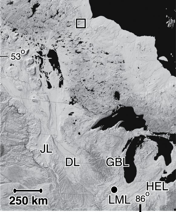
B

C

(A) Digital elevation shaded relief map of central North America. Solid circle is location of Tiskilwa Till exposures in Illinois. Open square is location of Sky Pilot Till exposure in Manitoba, JL denotes the James Lobe, DL denotes the Des Moines Lobe, GBL denotes the Green Bay Lobe, LML denotes the Lake Michigan Lobe, HEL denotes the Huron-Erie Lobe. (B) North-central Illinois location map (modified from Johnson and Hansel, 1999). Solid circle shows the location of the Friday 3 and Clear Creek sections. (C) Northern Manitoba location map (modified from Roy, 1998). Open square shows the location of the Limestone section.
(A) Carte des élévations du centre de l’Amérique du Nord. Le cercle plein et le carré ouvert montrent l’emplacement des parties exposées des tills de Tiskilwa, Illinois, et de Sky Pilot, Manitoba; le sigle JL montre l’emplacement du lobe de James, DL, le lobe de Des Moines, GBL, le lobe de Green Bay, LML, le lobe du Lac Michigan et HEL, le lobe de Huron-Érié. (B) Carte de localisation du centre-nord de l’Illinois (adaptation de Johnson and Hansel, 1999). Le cercle plein montre l’emplacment du site de Friday 3 et de Clear Creek. (C) Carte de localisation du nord du Manitoba (adaptation de Roy, 1998). Le carré ouvert montre l’emplacement de la section de Limestone.
Figure 2
A

B

C
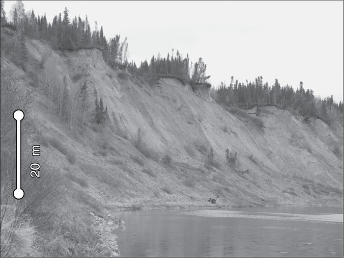
Bluff exposures. (A) Friday 3, IL. (B) Clear Creek, IL. (C) Limestone section, MB.
Sections exposées. (A) Friday 3, IL. (B) Clear Creek, IL. (C) Limestone, MB.
Results
Tiskilwa Till
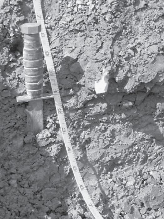
At the two Illinois sections, the Tiskilwa Till is a reddish-brown, massive, homogeneous, fine-grained diamicton 5 to 6 m thick (Figs. 3‑4). It overlies the grey, more heterogeneous Delavan Till with a ~1 m thick gradational contact. Thin sections of Tiskilwa Till from up to 2 m above the Tiskilwa-Delavan contact reveal small (<0.5 cm) inclusions of Delavan Till in the Tiskilwa Till matrix. At the Clear Creek section, the base of the Delavan Till is exposed and grades into underlying proglacial sediment over ~1 m thick interval (Fig. 3F). The Delavan and Tiskilwa Tills have a uniform grain size throughout the sections (Fig. 4A‑B; Table I). At the Clear Creek section, however, the gradational contact between the Delavan Till and underlying sediment shows greater variability in grain size. Also at this section, sand inclusions in both till units are up to 1 m thick, have abrupt contacts with the surrounding till, and are deformed in the direction of ice-flow. Some inclusions contain balls of Tiskilwa Till within the sand and have diapirs of till rising into the sand (Fig. 3D). If the sand contained any original sedimentary structures, then they have been erased by deformation.
The till contains glacially transported wood aligned with regional ice-flow, with greatest abundance near the base of the Friday 3 section (Fig. 4A; Table II). Radiocarbon dates on six pieces of wood range from 31.4 14C ka BP to >49.9 14C ka BP, with a general trend of decreasing age up-section followed by an increase in age at ~3 m.
Macrofabric is strong throughout the Tiskilwa Till, as indicated by principle eigenvalues (S1) between 0.74 and 0.85 (Fig. 4) with the fabric having a unimodal to spread unimodal shape (Hicock et al., 1996). Thin sections also indicate strong alignment of particles in the Tiskilwa Till matrix. Macrofabric principle eigenvectors (V1) shift direction upward through the section from N40E to N60E, returning to N40E near the top of the Tiskilwa Till (Fig. 4).
Figure 3
A

B
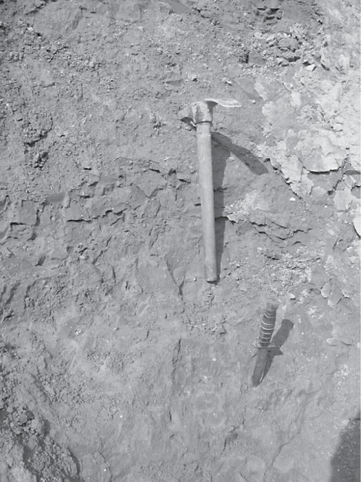
C
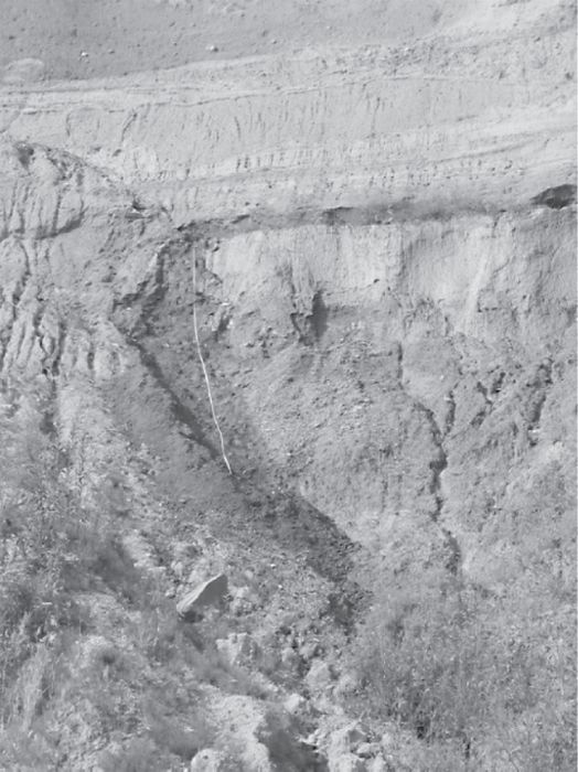
D

E
F

(A) Cleared exposure of Tiskilwa Till at Friday 3. (B) close up of uniform Tiskilwa Till from Friday 3. (C) Clear Creek exposure. (D) Deformed sand inclusion with Tiskilwa Till within the sand at Clear Creek. (E) The basal contact between the Delavan Till and underlying sediment at Clear Creek. (F) Gradational contact between Delavan Till and underlying sediment at Clear Creek.
(A) Partie exposée du till de Tiskilwa au site de Friday 3. (B) Vue rapprochée de la partie homogène du till de Tiskilwa au site de Friday 3. (C) Partie exposée du site de Clear Creek. (D) Inclusion de sable dans le till de Tiskilwa au site de Clear Creek. (E) Zone de contact basal entre le till de Delavan et les sédiments sous-jacents au site de Clear Creek. (F) Zone de contact gradationnel entre le till de Delavan et les sédiments sous-jacents au site de Clear Creek.
Figure 4
A

B

C

Tiskilwa Till section data. (A) Friday 3. (B) Clear Creek. Solid line is eigenvalues and dashed line is eigenvector azimuth. The radiocarbon date at 2.1 m from Friday 3 is >49.9 14C ka BP. (C) Pebble orientation from Friday 3 and Clear Creek. Numbers indicate the depth (m) in the section from which the data were collected.
Observations sur le till de Tiskilwa. (A) Friday 3. (B) Clear Creek. La ligne pleine représente la valeur propre et la ligne pointillée fait référence à l’azimuth du vecteur propre. La date au radiocarbone à 2,1 m au site de Friday 3 est >49.9 14C ka BP. (C) Orientation des galets aux sites de Friday 3 et de Clear Creek. Les chiffres indiquent la profondeur (m) où les données ont été récoltées.
Table I
Grain size data for till units with standard deviation

Sky Pilot Till
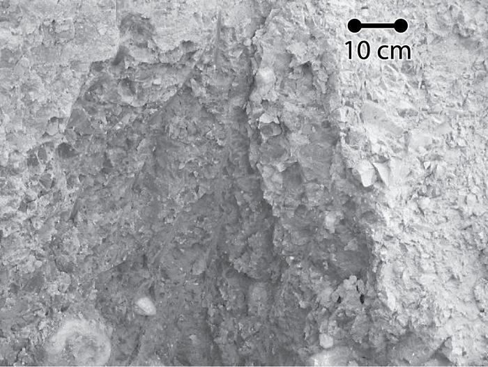
In the study area, the Sky Pilot Till is a massive, homogeneous diamicton overlain by proglacial and lacustrine sediment. It is ~6 m thick, with a 1‑m gradational contact into the underlying ~3 m thick Long Spruce Till (Figs. 5‑6). Long Spruce Till overlies the interglacial Nelson River Sediments (Dredge and Nielsen, 1985; Klassen, 1986; Nielsen et al., 1986, Dredge and Nixon, 1992; Roy, 1998), which are deformed into the matrix of the Long Spruce Till (Fig. 5C). The Nelson River Sediments have an abrupt basal contact with the underlying Amery Till. Deformed sand lenses are present in all three till units. Grain size of the Sky Pilot and Long Spruce Tills is relatively uniform throughout the units (Fig. 6; Table I).
Eigenvalues are moderately strong (S1 between 0.50 and 0.81) in the three till units at the Limestone section. In the Sky Pilot Till, there is a general trend of increasing strength up-section in 2 to 3 m increments. The stronger fabrics have a unimodal to spread unimodal shape while the weaker fabrics are spread bimodal in shape (Fig. 6; Hicock et al., 1996). Eigenvectors change orientation up-section from north-northeast in the Amery Till to east-southeast in the Long Spruce to northeast in the Sky Pilot Till, identifying significant changes in ice-flow direction associated with deposition of each till (Dredge and Nielsen, 1985; Nielsen et al., 1986; Dredge and Nixon, 1992; Thorleifson et al., 1992; Roy, 1998). Within the Sky Pilot Till, eigenvectors rotate up-section from N45E to N75E (Fig. 6).
Discussion
We interpret the sedimentological features of the Tiskilwa Till to be most consistent with deposition from a subglacial deforming layer. The heterogeneous basal facies of the Tiskilwa Till indicates that the older Delavan Till was reworked and redeposited within a zone of mixing during the Tiskilwa ice readvance. The basal 1 m of the Delavan Till matrix also includes underlying sediments, suggesting a similar process of deformation and incorporation.
Further evidence of deformation is suggested by the sand inclusions. The sand may have been originally deposited in subglacial canals that were incised into the till at the base of the ice and subsequently deformed as they were entrained into the deforming subglacial sediment (Fig. 3D; Clark, 1997). Tiskilwa Till balls in the sand may have originated as englacial sediment that melted off the roof of a canal into the underlying canal sediments. Alternatively, the till balls may represent till that was detached and incorporated into a sand body during deformation of the sediment mass. The inclusion of these till balls in the sand rules out the synchronous deposition of the sand and till by melt-out because the till must have existed prior to sand deposition to have the till included in the sand.
Table II
14C ages from Friday 3 section, IL

The fabric data of the Tiskilwa and Delavan Tills are strong throughout its thickness. Classical fabric interpretation (e.g. Dowdeswell and Sharp, 1986; Hicock et al., 1996; Lian et al., 2003) would suggest that till genesis can be inferred from fabric strength and shape. However, laboratory results using a ring-shear device suggest that fabric strength is not unique to a specific genesis (Hooyer and Iverson, 2000b). Fabric strength in these laboratory-deformed tills increased with increasing accumulated strain with highly strained tills having a strong fabric (similar to lodgement and melt-out tills). Similarly, these fabrics exhibited unimodal to spread unimodal shape similar to lodgement or melt-out tills suggesting that fabric shape is also not indicative of genesis. Based on the independent evidence for deformation (gradational basal contacts with reworked till and deformed sand inclusions), we interpret our fabric data from the Tiskilwa and Sky Pilot Tills as indicators of accumulated strain and local ice-flow direction (Bennett et al., 1999; Larsen et al., 2004) but do not attempt to infer genesis from them.
The consistently strong fabric in the Tiskilwa Till suggests that the till underwent substantial strain throughout its thickness over time (Hooyer and Iverson, 2002; Larsen et al., 2004), regardless of the depth of the deformation at any one location or time. Fabric data from Tiskilwa Till ~50 km to the northeast of our sites have shown similar strong fabrics (Johnson and Hansel, 1990, 1999) suggesting that the strong fabric of the Tiskilwa Till is regionally extensive. We interpret the up-section shift of the eigenvectors observed at two locations km’s (check distance) apart to reflect changes in local ice-flow direction. These changes, however, are consistent with regional ice-flow changes associated with the advance and retreat of the Lake Michigan Lobe (Johnson and Hansel, 1999). Specifically, initial advance of the lobe over the site would have been from a more northeasterly direction, with flow shifting to a more westerly direction as the margin reached its limit and ice thickened over the site. A reverse flow-direction sequence would then occur as the lobe retreated and ice thinned over the site. The preservation of the shifting macrofabric orientation constrains the maximum depth of the deforming layer to ≤1 m thick. If the till was actively deforming to a greater depth, then earlier ice-flow directions recorded by the macrofabric would have been re-oriented by subsequent changes in ice-flow direction (e.g. MacClintock and Dreimanis, 1964).
Figure 5
A

B
C

D

(A) Limestone section of the Sky Pilot Till. (B) Close up of the Sky Pilot Till. (C) Deformed sediment into the Long Spruce Till. (D) Deformed sand lens in the Sky Pilot Till.
(A) Section de Limestone du till de Sky Pilot. (B) Vue rapprochée du till de Sky Pilot. (C) Sédiments déformés à l’intérieur du till de Long Spruce. (D) Lentilles de sable déformées dans le till de Sky Pilot.
The tills exposed along the Nelson River, Manitoba, display sedimentological features generally similar to the Tiskilwa Till, and we similarly attribute the formation of these features as a result of subglacial sediment deformation in accord with the interpretations of Roy (1998). The deformed sand inclusions may be remnant subglacial canals of a basal drainage system, as we suggested for the Tiskilwa Till, or they may represent interstadial events (Dredge and Nixon, 1992). Regardless of their origin, they are deformed into the till implying that the till was deformed with them. Gradational contacts between the Sky Pilot and the Long Spruce Tills, and between the Long Spruce Till and underlying interglacial sediment (Figs. 5 and 6A), suggest a similar process of deformation and incorporation of preexisting sediments into an actively deforming sediment layer. Based on the gradational contacts, we suggest that much of the till was transported in the deforming layer and originated from the mixing of the underlying sediment with till derived from up-ice. The till was then deposited when strain migrated upwards with the delivery of new till either released from the overlying ice or advected from up-ice.
Figure 6
A

B
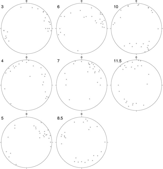
(A) Sky Pilot Till section data from the Limestone section. Solid line is eigenvalues and dashed line is eigenvector azimuth. (B) Pebble orientation from the Limestone section. Numbers indicate depth (m) in the section from which the data were collected.
(A) Observations sur la section de Limestone du till de Sky Pilot. La ligne pleine représente les valeurs propres et la ligne pointillée fait référence à l’azimuth du vecteur propre. (B) Orientation des galets au site de Limestone. Les chiffres indiquent la profondeur (m) où les données ont été récoltées.
In the case of the Sky Pilot Till, the up-section shift in eigenvector orientation indicates that local ice-flow migrated westward as the till was deposited, consistent with changes in regional ice-flow (Dyke, 2004). Fabric orientations of Roy (1998) from the Sky Pilot Till are consistent with our fabric data showing a shift in ice flow towards the west up-section. The Sky Pilot Till, however, may exhibit variability in fabric orientation based on four fabric measurements distributed over ~20 km (Nielsen et al., 1986). Our data, supported by that of Roy (1998), suggest that fabric orientation changed with depth in the till as ice-flow direction changed, indicating that observed regional fabric variability may be due to the varying depth at which the till fabric was measured. Multiple fabrics distributed throughout the till thickness are thus needed to distinguish local fabric variability from ice-flow variability.
Such changes in ice-flow direction recorded in till sections suggest that vertical examination of till fabric may delineate past changes in ice-flow during one advance and also the position of ice-flow divides in regions that otherwise lack surficial flow indicators (e.g. drumlins, flutes, lineations, striations). Unlike the Tiskilwa Till, however, the fabric strength of the Sky Pilot Till generally increases up-section in 2 to 3 m increments, suggesting an up-section increase in accumulation of strain, consistent with increasing sediment strength and decreasing strain with depth in the till. Similar to the Tiskilwa Till, the preservation of the migrating eigenvectors limits the depth of deformation in the Sky Pilot Till to ≤1 m. Till may have been deposited continuously at both locations in Illinois and Manitoba as indicated by the migration of eigenvector orientation up-section that reflect changes in ice-flow direction (Johnson and Hansel, 1999; Dyke, 2004).
It is interesting that the Tiskilwa and Sky Pilot Tills show similar features such as their deformed sand inclusions, basal contacts and migrating till fabrics, despite their differing depositional contexts with respect to the Laurentide Ice Sheet. While both tills were deposited by warm-based ice, the Tiskilwa Till was deposited under a fast-moving lobe of the ice sheet, whereas the Sky Pilot Till was deposited near the centre of the ice sheet near or under an ice divide. The similarities between the two tills suggest that similar ice sheet motion and depositional processes were operating at both locations under the Laurentide Ice Sheet.
Hooyer and Iverson (2000a) used laboratory and field data to show that the contact between two tills in Minnesota contained a 40‑cm thick mixed zone. They argued that the weak fabric strength (principle eigenvalues (S1) between 0.44 and 0.67) of the till deposited by the Des Moines Lobe in Iowa and Minnesota (Fig. 1) did not experience strain >2, and thus attributed much of the lobe motion to sliding (Hooyer and Iverson, 2002). This is in contrast to our data from the Lake Michigan Lobe (east of the Des Moines Lobe) that show mixing between the Delavan and Tiskilwa Tills in a zone up to 1 m thick and that the Tiskilwa Till experienced greater strain. Accordingly, we suggest that, to a first order, these sedimentological properties of tills (basal contacts, fabric strengths) provide some diagnostic information with respect to distinguishing between a large contribution to ice motion by sliding versus sediment deformation, as well as the depth of the deformation zone (e.g. Larsen et al., 2004). In particular, we would expect that where sliding makes a larger contribution to ice motion, strain in the underlying till would be smaller and hence the fabric of the underlying till to be weaker. Where conditions favor a larger contribution by deformation, fabrics would presumably be stronger. The central question then becomes what properties of the till and conditions of the subglacial environment determine the relative contribution of sliding or deformation.
Conclusions
Our observations of till sections from the Lake Michigan Lobe and Hudson Bay Lowlands suggest that sediment deformation may have occurred to depths up to 1 m in the Tiskilwa Till and Sky Pilot Till. The vertical uniformity of the strong fabric in the Tiskilwa Till suggests large accumulated strain in a deforming section up to 1 m thick that migrated upward over time. The upward-strengthening fabric in the Sky Pilot Till, on the other hand, suggests an upward increase in strain through time. The relative contributions of sliding and sediment deformation cannot be discerned from the observations reported here. The uniformly strong fabric of the Tiskilwa Till and the strong fabric in the upper portion of the Sky Pilot Till, however, leave open the prospect that whatever deformation took place involved relatively high strain rates and sufficiently thick deforming layers to transport a significant mass of fine-grained sediment.
Parties annexes
Acknowledgements
We thank Aubri Jenson for assistance in the field, Ardith Hansel for discussions relating to the Putnam County, IL, sites, and Martin Roy for discussions relating to the Limestone, MB, site. We also thank Chandrakant Desai, Dinshaw Contractor, and Shantanu Sane for particularly fruitful discussions. Reviews by S. Hicock and an anonymous reviewer improved this manuscript along with suggestions from A. Plouffe. This work was supported by NSF grants (EAR‑0229513 and EAR‑0229907) to Jenson and Clark.
References
- Alley, R.B., 1991. Deforming-bed origin for southern Laurentide till sheets? Journal of Glaciology, 37 : 67‑76.
- Alley, R.B., Blankenship, D.D., Bentley, C.R. and Rooney, S.T., 1986. Deformation of till beneath ice stream B, West Antarctica. Nature, 322 : 57‑59.
- Benn, D.I. and Ringrose, T.J., 2001. Random variation of fabric eigenvalues: implications for the use of a-axis fabric data to differentiate till facies. Earth Surface Processes and Landforms, 26 : 295‑306.
- Bennett, M.R., Waller, R.I., Glasser, N.F., Hambrey, M.J. and Huddart, D., 1999. Glacibenic clast fabrics: genetic fingerprint or wishful thinking. Journal of Quaternary Science, 14 : 125‑135.
- Bentley, C.R., 1997. Rapid sea-level rise soon from West Antarctic Ice Sheet collapse? Science, 275 : 1077‑1078.
- Blankenship, D.D., Bentley, C.R., Rooney, S.T. and Alley, R.B., 1986. Seismic measurements reveal a saturated porous layer beneath an active Antarctic ice stream. Nature, 322 : 54‑57.
- Boulton, G.S., Dobbie, K.E. and Zatsepin, S., 2001. Sediment deformation beneath glaciers and its coupling to the subglacial hydraulic system. Quaternary International, 86 : 3‑28.
- Clark, P.U., 1994. Unstable behavior of the Laurentide Ice Sheet over deforming sediment and its implication for climate change. Quaternary Research, 41 : 19‑25.
- Clark, P.U., 1997. Sediment deformation beneath the Laurentide Ice Sheet, p. 81‑97. In I.P. Martini, ed., Late Glacial and Postglacial Environmental Changes Quaternary, Carboniferous-Permian, and Proterozoic. Oxford University Press, London.
- Clark, P.U., Alley, R.B. and Pollard, D., 1999. Northern Hemisphere ice-sheet influences on global climate change. Science, 286 : 1104‑1111.
- Clayton, L., Mickelson, D.M. and Attig, J.W., 1989. Evidence against pervasively deformed bed material beneath rapidly moving lobes of the southern Laurentide Ice Sheet. Sedimentary Geology, 62 : 203‑208.
- Dowdeswell, J.A. and Sharp, M.J., 1986. Characterization of pebble fabrics in modern terrestrial glacigenic sediments. Sedimentology, 33 : 699‑710.
- Dredge, L.A. and Nielsen, E., 1985. Glacial and interglacial deposits in the Hudson Bay lowlands: a summary of sites in Manitoba, p. 247‑257. In Current Research, Part A. Geological Survey of Canada, Ottawa, Paper 85‑1A.
- Dredge, L.A. and F.M., Nixon, 1992. Glacial and Environmental Geology of Northeastern Manitoba. Geological Survey of Canada, Ottawa, Memoir 432, 80 p.
- Dyke, A.S., 2004. An outline of North American Deglaciation with emphasis on central and northern Canada, p. 373‑424. In J. Ehlers and P.L. Gibbard, eds., Quaternary Glaciations-Extant and Chronology, Part II. Elsevier Sciences and Technology Books, Amsterdam.
- Engelhardt, H. and Kamb, B., 1998. Basal sliding of Ice Stream B, West Antarctica. Journal of Glaciology, 44 : 223‑230.
- Fischer, U.H. and Clarke, G.K.C., 1994. Ploughing of subglacial sediment. Journal of Glaciology, 40 : 97‑106.
- Hansel, A.K. and Johnson, W.H., 1996. Wedron and Mason Groups: Lithostratigraphic reclassification of deposits of the Wisconsin Episode, Lake Michigan area. Illinois State Geological Survey Bulletin, 104 p.
- Hicock, S.R., 1992. Lobe interactions and rheologic superposition in subglacial till near Bradtville, Ontario, Canada. Boreas, 21 : 73‑88.
- Hicock, S.R. and Dreimanis, A., 1992. Deformation till in the Great Lakes region: implications for rapid flow along the south-central margin of the Laurentide Ice Sheet. Canadian Journal of Earth Sciences, 29 : 1565‑1579.
- Hicock, S.R., Goff, J.R., Lian, O.B. and Little, E.C., 1996. On the interpretation of subglacial till fabric. Journal of Sedimentary Research, 66 : 928‑934.
- Hooke, R.L.B., Hanson, B., Iverson, N.R., Jansson, P. and Fischer, U.H., 1997. Rheology of till beneath Storglaciären, Sweden. Journal of Glaciology, 43 : 172‑179.
- Hooyer, T.S. and Iverson, N.R., 2000a. Diffusive mixing between shearing granular layers: constraints on bed deformation from till contacts. Journal of Glaciology, 46 : 641‑651.
- Hooyer, T.S. and Iverson, N.R., 2000b. Clast-fabric development in a shearing granular material: Implications for subglacial till and fault gauge. Geological Society of America Bulletin, 112 : 683‑692.
- Hooyer, T.S. and Iverson, N.R., 2002. Flow mechanisms of the Des Moines lobe of the Laurentide Ice Sheet. Journal of Glaciology, 48 : 575‑586.
- Humphrey, N., Kamb, B., Fahnestock, M. and Engelhardt, H., 1993. Characteristics of the bed of the lower Columbia Glacier, Alaska. Journal of Geophysical Research, 98 : 837‑846.
- Iverson, N.R., Jansson, P. and Hooke, R.L.B., 1994. In-situ measurement of the strength of deforming subglacial till. Journal of Glaciology, 40 : 497‑503.
- Iverson, N.R., Hooyer, T.S. and Baker, R.W., 1998. Ring-shear studies of till deformation: Coulomb-plastic behavior and distributed strain in glacier beds. Journal of Glaciology, 44 : 634‑642.
- Jenson, J.W., Clark, P.U., MacAyeal, D.R., Ho, C. and Vela, J.C., 1995. Numerical modeling of advective transport of saturated deforming sediment beneath the Lake Michigan Lobe, Laurentide Ice Sheet. Geomorphology, 14 : 157‑166.
- Johnson, W.H. and Hansel, A.K., 1990. Multiple Wisconsinan glacigenic sequences at Wedron, Illinois. Journal of Sedimentary Petrology, 60 : 26‑41.
- Johnson, W.H. and Hansel, A.K., 1999. Wisconsin Episode glacial landscape of central Illinois: a product of subglacial deformation process? Geological Society of America, Special Paper 337, 121‑135.
- Kamb, B., 1991. Rheological nonlinearity and flow instability in the deforming bed mechanism of ice stream motion. Journal of Geophysical Research, 96 : 16585‑16595.
- Klassen, R.W., 1986. Surficial geology of north-central Manitoba. Geological Survey of Canada, Ottawa, Memoir 419, 57 p.
- Larsen, N.K. and Piotrowski, J.A., 2003. Fabric in a basal till succession and its significance for reconstructing subglacial processes. Journal of Sedimentary Research, 73 : 725‑734.
- Larsen, N.K., Piotrowski, J.A. and Kronborg, C., 2004. A multiproxy study of basal till: a time-transgressive accretion and deformation hypothesis. Journal of Quaternary Science, 19 : 9‑21.
- Lian, O.B., Hicock, S.R. and Dreimanis, A., 2003. Laurentide and Cordilleran fast ice flow: some sedimentological evidence from Wisconsinan subglacial till and its substrate. Boreas, 32 : 102‑113.
- MacAyeal, D.R., 1992. Irregular oscillations of the West Antarctic Ice Sheet. Nature, 359 : 29‑32.
- MacAyeal, D.R., 1993. Binge/purge oscillations of the Laurentide Ice Sheet as a cause of the North Atlantic’s Heinrich events. Paleoceanography, 8 : 775‑784.
- MacClintock, P. and Dreimanis, A., 1964. Orientation of till fabric by overriding glacier in the St. Lawrence Valley. American Journal of Science, 262 : 133‑142.
- Mark, D.M., 1973. Analysis of axial orientation data, including till fabric. Geological Society of America Bulletin, 84 : 1369‑1373.
- Marshall, S.J. and Clark, P.U., 2002. Basal temperature evolution of North American ice sheets and implications for the 100‑kyr cycle. Geophysical Research Letters, 29 : doi: 10.1029/2002GL015192.
- Mickelson, D.M., Clayton, L., Fullerton, D.S. and Burns, H.W., Jr., 1983. The late Wisconsin glacial record of the Laurentide Ice Sheet in the U.S., p. 3‑37. In S.C. Porter, ed., Late Quaternary Environments of the United States. University of Minnesota Press, vol. 1, 407 p.
- Nielsen, E., Morgan, A.V., Morgan, A., Mott, R.J., Rutter, N.W. and Causse, C., 1986. Stratigraphy, paleoecology, and glacial history of the Gillam area, Manitoba. Canadian Journal of Earth Sciences, 23 : 1641‑1661.
- Piotrowski, J.A., Mickelson, D.M., Tulaczyk, S., Krzyszkowski, D. and Junge, F.W., 2001. Were deforming subglacial beds beneath past ice sheets really widespread? Quaternary International, 86 : 139‑150.
- Piotrowski, J.A., Larsen, N.K. and Junge, F.W., 2004. Reflections on soft subglacial beds as a mosaic of deforming and stable spots. Quaternary Science Reviews, 23 : 993‑1000.
- Roy, M., 1998. Pleistocene stratigraphy of the lower Nelson River area – implications for the evolution of the Hudson Bay lowland of Manitoba, Canada, M.Sc. Thesis, University of Québec, 220 p.
- Thorleifson, L.H., 1989. Quaternary stratigraphy of the central Hudson Bay Lowland, northern Ontario, Ph.D. Thesis, University of Colorado, 363 p.
- Thorleifson, L.H., Wyatt, P.H., Shilts, W.W. and Nielsen, E., 1992. Hudson Bay Lowland Quaternary Stratigraphy: evidence for early Wisconsinan glaciation centered in Quebec, p. 207‑220. In P.U. Clark and P.D. Lea, eds., The Last Interglacial-Glacial Transition in North America. Geological Society of America, Special Paper 270, 317 p.
- Wickham, S.S. and Johnson, W.H., 1981. The Tiskilwa Till: A regional view of its origin and depositional processes. Annals of Glaciology, 2 : 176‑182.
Liste des figures
A
B
C
(A) Digital elevation shaded relief map of central North America. Solid circle is location of Tiskilwa Till exposures in Illinois. Open square is location of Sky Pilot Till exposure in Manitoba, JL denotes the James Lobe, DL denotes the Des Moines Lobe, GBL denotes the Green Bay Lobe, LML denotes the Lake Michigan Lobe, HEL denotes the Huron-Erie Lobe. (B) North-central Illinois location map (modified from Johnson and Hansel, 1999). Solid circle shows the location of the Friday 3 and Clear Creek sections. (C) Northern Manitoba location map (modified from Roy, 1998). Open square shows the location of the Limestone section.
(A) Carte des élévations du centre de l’Amérique du Nord. Le cercle plein et le carré ouvert montrent l’emplacement des parties exposées des tills de Tiskilwa, Illinois, et de Sky Pilot, Manitoba; le sigle JL montre l’emplacement du lobe de James, DL, le lobe de Des Moines, GBL, le lobe de Green Bay, LML, le lobe du Lac Michigan et HEL, le lobe de Huron-Érié. (B) Carte de localisation du centre-nord de l’Illinois (adaptation de Johnson and Hansel, 1999). Le cercle plein montre l’emplacment du site de Friday 3 et de Clear Creek. (C) Carte de localisation du nord du Manitoba (adaptation de Roy, 1998). Le carré ouvert montre l’emplacement de la section de Limestone.
A
B
C
Bluff exposures. (A) Friday 3, IL. (B) Clear Creek, IL. (C) Limestone section, MB.
Sections exposées. (A) Friday 3, IL. (B) Clear Creek, IL. (C) Limestone, MB.
A
B
C
D
E
F
(A) Cleared exposure of Tiskilwa Till at Friday 3. (B) close up of uniform Tiskilwa Till from Friday 3. (C) Clear Creek exposure. (D) Deformed sand inclusion with Tiskilwa Till within the sand at Clear Creek. (E) The basal contact between the Delavan Till and underlying sediment at Clear Creek. (F) Gradational contact between Delavan Till and underlying sediment at Clear Creek.
(A) Partie exposée du till de Tiskilwa au site de Friday 3. (B) Vue rapprochée de la partie homogène du till de Tiskilwa au site de Friday 3. (C) Partie exposée du site de Clear Creek. (D) Inclusion de sable dans le till de Tiskilwa au site de Clear Creek. (E) Zone de contact basal entre le till de Delavan et les sédiments sous-jacents au site de Clear Creek. (F) Zone de contact gradationnel entre le till de Delavan et les sédiments sous-jacents au site de Clear Creek.
A
B
C
Tiskilwa Till section data. (A) Friday 3. (B) Clear Creek. Solid line is eigenvalues and dashed line is eigenvector azimuth. The radiocarbon date at 2.1 m from Friday 3 is >49.9 14C ka BP. (C) Pebble orientation from Friday 3 and Clear Creek. Numbers indicate the depth (m) in the section from which the data were collected.
Observations sur le till de Tiskilwa. (A) Friday 3. (B) Clear Creek. La ligne pleine représente la valeur propre et la ligne pointillée fait référence à l’azimuth du vecteur propre. La date au radiocarbone à 2,1 m au site de Friday 3 est >49.9 14C ka BP. (C) Orientation des galets aux sites de Friday 3 et de Clear Creek. Les chiffres indiquent la profondeur (m) où les données ont été récoltées.
A
B
C
D
(A) Limestone section of the Sky Pilot Till. (B) Close up of the Sky Pilot Till. (C) Deformed sediment into the Long Spruce Till. (D) Deformed sand lens in the Sky Pilot Till.
(A) Section de Limestone du till de Sky Pilot. (B) Vue rapprochée du till de Sky Pilot. (C) Sédiments déformés à l’intérieur du till de Long Spruce. (D) Lentilles de sable déformées dans le till de Sky Pilot.
A
B
(A) Sky Pilot Till section data from the Limestone section. Solid line is eigenvalues and dashed line is eigenvector azimuth. (B) Pebble orientation from the Limestone section. Numbers indicate depth (m) in the section from which the data were collected.
(A) Observations sur la section de Limestone du till de Sky Pilot. La ligne pleine représente les valeurs propres et la ligne pointillée fait référence à l’azimuth du vecteur propre. (B) Orientation des galets au site de Limestone. Les chiffres indiquent la profondeur (m) où les données ont été récoltées.
Liste des tableaux
Table I
Grain size data for till units with standard deviation
Table II
14C ages from Friday 3 section, IL