
Résumés
Abstract
Late Wisconsinan dune activity is investigated within the present-day boreal forest and parkland regions of the northern Great Plains, Canada, to extend the understanding of the spatial and temporal eolian record. Optical ages from stabilized sand dunes document the timing of past activity. Eolian activity ranges from about 16 ka in west-central Alberta to 9 ka in northwestern Saskatchewan. Between about 16 and 13 ka, dune activity in central Alberta occurred in an ice-proximal tundra setting along the margins of the Laurentide and Cordilleran ice sheets. Predominant dune-forming winds were from the west and northwest. Dune activity continued in this area between about 13 and 11 ka within parkland and grassland settings as the Laurentide Ice Sheet retreated to the northeast. Winds continued to blow from the west and northwest, and the climate was likely influenced by an increasingly dominant Pacific air mass. Also beginning at about 13 ka, dune-forming winds along the margins of the retreating Laurentide Ice Sheet were influenced by anticyclonic winds from the southeast that were maintained until about 9 ka. As the Laurentide Ice Sheet retreated, these southeasterly anticyclonic winds were successively replaced by winds from the northwest associated with the Pacific air mass. Dune activity across the region terminated in a time-transgressive manner from the southwest, at about 11 ka, to the northeast, at about 9 ka, with the establishment of boreal forest vegetation and reduced wind strength.
Résumé
Les auteurs étudient l’activité dunaire au Wisconsinien tardif dans la forêt boréale et la prairie-parc actuelles des Grandes Plaines septentrionales du Canada, afin d’approfondir les connaissances sur l’évolution spatiotemporelle de l’activité éolienne. Les âges optiques mesurés sur des dunes de sable stabilisées permettent de reconstituer la chronologie de l’activité passée. Les âges de l’activité éolienne s’échelonnent entre 16 ka dans le centre-ouest de l’Alberta et 9 ka dans le nord-ouest de la Saskatchewan. Entre 16 et 13 ka, l’activité dunaire dans le centre de l’Alberta a eu lieu dans un environnement de toundra juxtaglaciaire le long des marges des inlandsis laurentidien et cordillérien. Les vents efficaces prédominants soufflaient de l’ouest et du nord-ouest. L’activité dunaire s’est poursuivie dans cette région entre 13 et 11 ka dans des environnements de prairie-parc et de prairie herbageuse, avec le recul de l’Inlandsis laurentidien vers le nord-est. Les vents ont continué de souffler de l’ouest et du nord-ouest, et le climat a probablement été influencé par une masse d’air du Pacifique de plus en plus dominante. Également au début de 13 ka, les vents efficaces le long des marges de l’Inlandsis laurentidien en recul ont été influencées par des vents anticycloniques du sud-ouest, qui ont duré jusqu’à 9 ka. Avec le retrait de l’Inlandsis laurentidien, ces vents ont été successivement remplacés par des vents du nord-ouest associés à la masse d’air du Pacifique. L’activité dunaire dans la région s’est terminée de façon diachrone à partir du sud-ouest, vers 11 ka, jusqu’au nord-est, vers 9 ka, par l’établissement d’une végétation forestière boréale et la diminution de la force des vents.
Corps de l’article
Introduction
Eolian deposits in the form of loess, sand sheets and dunes serve as important records of paleoclimate. In addition to placing potential limits on moisture balance at the time of formation and acting as sensitive indicators of vegetation cover, they record evidence of past wind regimes (Muhs and Bettis, 2000; Muhs and Zárate, 2001). Across the North American Great Plains, stratigraphic, geomorphic and chronologic studies of dune fields provide insights into eolian activity and stability in relation to Holocene climatic variability (Forman et al., 2001). However, due to extensive late Holocene reworking, Late Wisconsinan and earlier Holocene dune deposits are difficult to find (Muhs and Zárate, 2001), thereby limiting the applicability of older paleoclimate records.
In the past, geological evidence of former wind directions from eolian features was used in an attempt to validate atmospheric general circulation model (AGCM) simulated patterns of Late Wisconsinan and Holocene paleoclimatic parameters in North America (Kutzbach and Wright, 1985; COHMAP Members, 1988). However, evidence from mid-continental dune fields and loess deposits (Flemal et al., 1972; Warren, 1976; Wells, 1983 and others) showed that winds south of the glacial limit were from the west and northwest during full glacial conditions, although model outputs indicated that anticyclonic (easterly) winds prevailed.
However, a major obstacle to using evidence from eolian deposits at that time was an absence of age control (Kutzbach and Wright, 1985). Most paleowind evidence was derived from eolian features that were speculated to be Late Pleistocene in age, but that lacked sufficient dating of these deposits. Ahlbrandt et al. (1983) provided the first radiocarbon ages showing that most dune fields south of the Late Wisconsinan glacial limit, thought to have formed in the Late Pleistocene, record mostly mid- to late Holocene episodes of activity. Since then, numerous studies on the North American Great Plains have used radiocarbon, thermoluminescence and optical dating techniques to document episodes of Holocene dune activity (Madole, 1994; Muhs et al., 1997; Stokes and Swinehart, 1997; Forman et al., 2001; Wolfe et al., 2002a, 2002b, 2002c; Goble et al., 2004). Thus, reconstructing paleoclimatic parameters from dune fields in North America has remained an outstanding issue with respect to understanding late glacial climates and circulation patterns, and in verifying paleoclimatic simulations.
In this study, we extend investigations of the spatial and temporal record of dune activity of the northern Great Plains into the boreal forest regions of western Canada (Fig. 1). Geochronological data, together with glacial ice and paleo-vegetation distributions (Dyke et al., 2003, 2004), are used to develop a chronology of Late Wisconsinan dune activity, wind regimes, and paleoclimate in this northernmost extent of the Great Plains.
Dune fields on the northern Great Plains
Origins
With the exception of a few ice-free uplands, the northern Great Plains region was covered by glacial ice during the Late Wisconsinan (Fig. 1). As a result, source deposits for dune fields within the glacial limit are typically sandy glaciolacustrine or glaciofluvial outwash deposits (David, 1977; Muhs and Wolfe, 1999) associated with meltwaters of the Laurentide and Cordilleran ice sheets. Consequently, the maximum limiting ages of these dune fields are a function of the timing of deglaciation and subsequent drainage of proglacial lakes and rivers (Wolfe et al., 2006). In Canada, the chronology of maximum limiting age follows the trend of the receding Laurentide Ice Sheet, with oldest dune fields in the southwest and progressively younger dune fields towards the northeast (Fig. 2A).
More than 130 dune fields on the northern Great Plains collectively occupy over 40 000 km2 (Fig. 1). These dune fields are small in comparison to the central Great Plains dune fields located south of the Wisconsin glacial limit. This difference is due to the fact that glacial outwash, from which most northern Great Plains dune fields are derived, was limited in spatial extent by short-lived intervals of deposition during recession of the Laurentide Ice Sheet. In addition, these northern Great Plains dune fields have not migrated far from their original source (Muhs and Wolfe, 1999).
Today, the mostly-stabilized dune fields of the northern Great Plains contain primarily parabolic, and occasionally transverse, dunes (Fig. 3A‑B). Most parabolic dunes on the prairies, south of the present-day limit of the boreal forest (Fig. 1), are superimposed by stabilized or active blowouts that commonly destroy the primary dune morphology (Fig. 3C). Despite this secondary erosion, many dunes nevertheless contain buried soils, indicative of multiple periods of activity and stability (Wolfe et al., 2002b). Given the glacial history of the region, the dune fields in the prairies could potentially date to the Late Wisconsinan. Nevertheless, most dune fields yield ages related to the late Holocene (Fig. 1, #1‑10) and, more rarely, mid-Holocene (Fig. 1, #3, 9, 10). In contrast, most stabilized dune fields in the boreal forest are well preserved with few superimposed blowouts (Fig. 3A, B, E), though some show evidence of multiple wind directions (Fig. 3F). This suggests that a single episode of eolian activity, though with varying net sediment transport directions, was succeeded by stabilization. This apparent lack of reworking further suggests that these more northerly Great Plains dune fields may contain older eolian records than those to the south, since much of this northern region has been vegetated by boreal forest since ca. 10 to 9 cal ka BP[1] (Dyke et al., 2004).
Previous work
Eolian deposits in the Canadian portion of the northern Great Plains were extensively mapped and described by David (1977), providing a basis for the regional interpretation of sand dunes. Past detailed chronologic investigations have been restricted to the prairie ecozone (Fig. 1, #1‑10), whereas studies in the boreal forest document eolian deposits in the context of surficial mapping, timing of post-glacial events, paleowind regimes, and stratigraphy (Fig. 1, #11‑16). These latter studies suffered from a lack of absolute dating control, with the relative timing of eolian activity inferred by deglacial and post-glacial events.
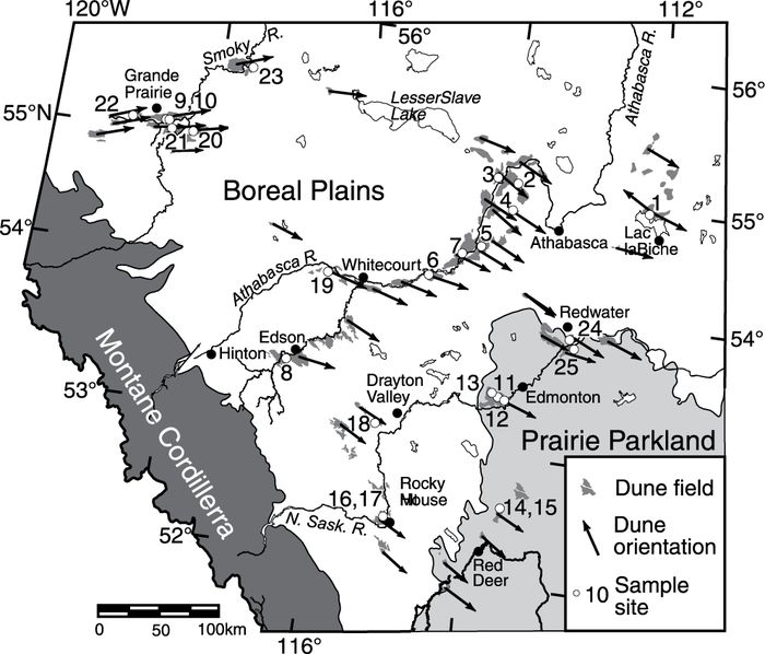
Figure 1

The northern Great Plains, showing dune fields (after Muhs and Wolfe, 1999; Muhs and Zárate, 2001 and Wolfe, 2001), extent of Wisconsin glacial ice (WGI) at ca. 21.4 cal ka (after Dyke et al., 2003), and relevant eolian studies. Shaded areas in boxes show regions where optical dating was used in the present study (SH = Sand Hills).
Sheyenne Delta dunes (Hopkins and Running, 2000)
Minot SH (Muhs et al., 1997)
Glacial Lake Hind Basin (Running et al., 2002; Wallace, 2002)
Brandon SH (David,1977; Wolfe et al., 2000; 2002a)
Cypress Hills (Catto, 1983)
Southwestern Alberta (Beaty, 1975)
Great SH region (Wolfe et al., 2001)
Duchess dune field (Wolfe et al., 2002c)
South-central Saskatchewan (Wolfe et al., 2002b)
Central Saskatchewan (Wolfe et al., 2006)
Stony Plain SH (Westgate, 1970)
Grande Prairie dune field (Halsey et al., 1990; Halsey and Catto, 1994)
Watino SH (Henderson, 1959)
Cree Lake moraine region (Tremblay, 1961; David, 1981a; Fisher,1996)
Athabasca Sand Dunes (Carson and Maclean, 1986; David, 1981b; Raup and Argus, 1982)
Alberta (Odynsky, 1958)
Les Grandes Plaines septentrionales, où la carte montre les champs de dunes (d’après Muhs et Wolfe, 1999; Muhs et Zárate, 2001 et Wolfe, 2001), l’étendue de la glaciation Wisconsinienne aux alentours de 21,4 ka cal. (d’après Dyke et al., 2003), et des études éoliennes pertinentes. Les surfaces grisées montrent les régions où l’on a eu recours à la datation optique pour cette étude (SH = Sand Hills).
Figure 2
A

B
C

Study area and surrounding region. (A) Glacial limits and pro-glacial lakes at 15.6, 13.0, 10.2 and 9.0 cal ka BP (after Dyke et al., 2003) and distribution of dune fields (after Wolfe, 2001). (B) Location of optical-dating samples collected from central Alberta. Dune orientations derived from Pfeiffer and Wolfe (2002) and this study. (C) Location of optical-dating sample collected from stabilized dune at Sandy Lake, NWT.
La région à l’étude et ses environs. (A) Limites glaciaires, lacs proglaciaires à 15,6, 13,0, 10,2 et 9,0 k cal. BP (d’après Dyke et al., 2003) et répartition des champs de dunes (d’après Wolfe, 2001). (B) Lieu de prélèvement des échantillons soumis à une datation optique dans le centre de l’Alberta. Orientations des dunes dérivées de Pfeiffer et Wolfe (2002) et de la présente étude. (C) Lieu de prélèvement d’un échantillon pour datation optique provenant d’une dune stabilisée à Sandy Lake, dans les Territoires du Nord-Ouest.
Previous studies of dune fields in Alberta suggest differing chronologies. Stabilized parabolic dunes indicating westerly to southwestly winds were investigated by Halsey et al. (1990), in the vicinity of Grande Prairie, Alberta (Fig. 1, #12). The authors speculated that the dunes formed after deglaciation, and were of early to mid-Holocene age. Dune deposits derived from glaciolacustrine sediments in the vicinity of Watino (Fig. 1, #13), northeast of Grande Prairie, indicate paleowinds from the west (Henderson, 1959). Here, Henderson (1959) interpreted dune formation under the influence of periglacial winds, post-dating drainage of glacial lakes north of Grande Prairie. In contrast, eolian sands in the Stony Plain sand hills southwest of Edmonton contain a paleosol with Mazama Ash (Fig. 1, #11), indicating eolian activity post-dating about 7.7 cal ka BP (Westgate, 1970).
Effective wind directions throughout Alberta have been derived from dune orientations (Fig. 1, #16; Odynsky, 1958). In central Alberta, the effective dune building winds were generally from the northwest, whereas in southern Alberta, they were from the southwest, similar to the average pattern of the direction of modern-day strong winds. In southern Alberta, coulee alignment with the present-day strongest Chinook winds from the southwest was also noted (Fig. 1, #6; Beaty, 1975). In contrast, ventifacts and wind-eroded grooves on bedrock surfaces, north and west of Fort McMurray, Alberta, record effective winds that differ from present-day northeasterly winds (Fig. 1, #14; Tremblay, 1961). From these features, Tremblay (1961) concluded that strong winds in this area had blown from southeast (~145°) soon after deglaciation.
In the Cree Lake region of northern Saskatchewan, David (1981a) interpreted southeasterly paleowinds as responsible for the formation of elongate parabolic dunes (Fig. 1, #14). He suggested that these dunes were probably active from about 10 to 8.8 ka BP, based on the timing of the local ice front position (Prest, 1969), and were rapidly stabilized by vegetation due to a change in local climate when the ice retreated further. David (1981a) speculated that the southeasterly dune-forming winds were derived from anticyclonic winds originating from a stationary high-pressure centre over the ice sheet, as proposed by Bryson and Wendland (1967). This interpretation supported AGCM simulations, which modeled a weakened but persistent anticylonic circulation around the Laurentide Ice Sheet between 12 and 9 ka BP (Kutzbach and Wright, 1985). With further retreat of the ice front, wind directions in the region changed and winds blew from the north and northwest, causing local deformation of dunes prior to stabilization (Fig. 3F). Fisher (1996) also investigated paleowind directions derived from ventifacts and sand dunes in the Cree Lake area, relying on regional radiocarbon ages and deglacial events for dating control. He suggested that eolian and periglacial processes were dominant from ca. 11 to 10.5 ka BP under local katabatic and regional anticyclonic winds, with eolian processes continuing as late as 9.9 ka BP.
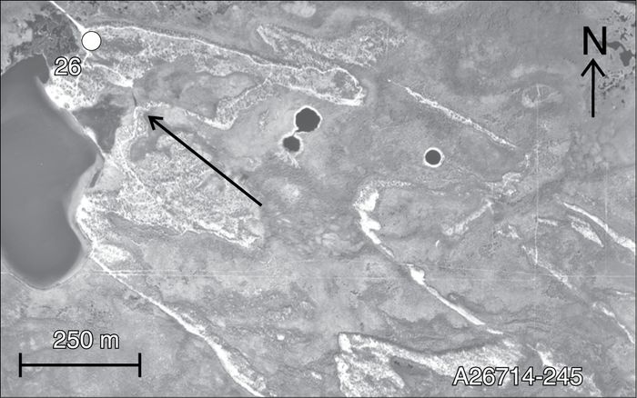
Figure 3
A

B

C

D

E
F
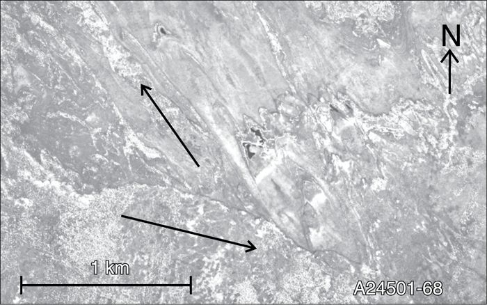
Characteristic dune fields of the Canadian northern Great Plains with optical dating sample locations (where relevant) and primary transporting wind directions (indicated by arrows) as derived from dune orientations. (A) Stabilized parabolic dunes, Pipestone Sand Hills near Grande Prairie. (B) Stabilized transverse dunes, Holmes Crossing Sand Hills near Whitecourt. (C) Stabilized parabolic dunes and blowouts, Stony Plain Sand Hills near Edmonton. (D) Stabilized parabolic dunes, Lac la Biche Sand Hills. (E) Stabilized parabolic dunes, Wood Buffalo Sand Hills near Hay River. (F) Stabilized parabolic dunes in northwestern Alberta indicating older transporting winds from the southeast and more recent transporting winds from the west-northwest.
Champs de dunes caractéristiques des Grandes Plaines septentrionales du Canada, avec les lieux de prélèvement des échantillons pour la datation optique, de même que les principales directions des vents efficaces établies à partir de l’orientation des dunes. (A) Dunes paraboliques stabilisées, Pipestone près de Grande Prairie, (B) Dunes transversales stabilisées, Holmes Crossing près de Whitecourt. (C) Dunes paraboliques stabilisées et creux de déflation, Stony Plain près d’Edmonton. (D) Dunes paraboliques stabilisées, Lac la Biche. (E) Dunes paraboliques stabilisées, Wood Buffalo Sand Hills près de la rivière Hay. (F) Dunes paraboliques stabilisées dans le nord-ouest de l’Alberta qui indique les vents efficaces du sud-est, plus anciens, et des vents efficaces de l’ouest-nord-ouest, plus récents.
David (1981a) emphasized that dune activity across this most northerly region of the Great Plains should not be considered synchronous, nor should it be considered to have lasted the same length of time everywhere. It probably began earlier farther west, as soon as the ice sheet disappeared, than it did in the east. He suggested that it apparently lasted for only a short period of time in the westernmost dune areas, whereas it may have lasted longest in the Wood Buffalo Sand Hills of Alberta.
Despite studies documenting the occurrence, stratigraphy and relative timing of dune activity in the Canadian portion of the northern Great Plains, a regional picture of past dune activity is still lacking. In addition, given the apparent complexities in the relative timing of eolian events, it is important that detailed chronologic investigations be conducted to determine the timing of eolian activity relative to deglacial and Holocene events.
This study focuses on the northwestern extent of the northern Great Plains (Figs. 1, 2A), in central Alberta from Red Deer to Lesser Slave Lake and eastward from Grande Prairie to Lac la Biche (Fig. 2B). The majority of the area is in the boreal plains except for the southeast portion, which is in the aspen parkland region of the prairies. An additional site located southeast of Hay River, in the Northwest Territories, was investigated (Fig. 2C).
Methods
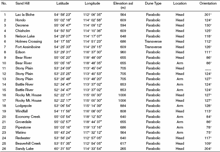
To compare the timing of dune field activity, sampling strategy for optical dating focused on determining the most recent episode of dune activity. Twenty-six samples were obtained from the heads or arms of stabilized parabolic and transverse dunes (Table I) that were typically easily recognizable on airphotos (Fig. 3). Most samples were collected from a depth of at least one metre, in shallow pits excavated into roadcuts or the surface of stabilized dunes to avoid potential mixing of the parent dune sands with overlying pedogenically-altered sediment. Stratigraphy was described at each sample site, noting depth of pedogenisis, orientation of bedding planes within eolian sediments, and the occurrence of buried soils. Dune orientations, reflecting the dominant wind directions in which the dunes formed, were determined in the field. The morphology and orientation of stabilized dunes across the entire region were also derived from aerial photographs (Pfeiffer and Wolfe, 2002). Among the dune fields sampled were those investigated by Henderson (1959), Halsey et al. (1990) and Westgate (1970); thus providing a chronology for these areas (Fig. 1, #11, 12, 13).
Optical dating measures the time elapsed since mineral grains were last exposed to sunlight, which usually corresponds to the time since the grains were buried. Wintle (1997), Aitken (1998), Huntley and Lian (1999), and Lian and Huntley (2001) describe techniques, and Lian et al. (2002) provide methodological details applied to this study. Sand sized K‑feldspar grains (180‑250 µm diameter) were dated by excitation with near-infrared (1.4 eV, ~880 nm) photons and measuring the violet (3.1 eV, 400 nm) photons emitted in response. The multiple-aliquot additive-dose with thermal transfer correction method was used to determine the equivalent dose and this, together with a measure of the environmental dose rate and a correction for anomalous fading, was used to calculate the ages (Tables II and III). This technique has been used successfully elsewhere on sand dunes in the Canadian Great Plains (Wolfe et al., 2001, 2002a, 2002b, 2006), with ages that are in agreement with radiocarbon ages (Wolfe et al., 2002a) and an optical age derived from quartz (Huntley and Lamothe, 2001).
The average analytical uncertainty in the optical ages at 1σ is about 7% of the reported age, but a few (SFU‑O‑269, 274 and 275) are about 10% or greater. About half of this uncertainty is derived from uncertainty in the fading rates.
Results and discussion
Stratigraphy and optical ages
Most soils on stabilized dunes contain some expression of O/Ah/B/C horizons. Ah-horizons were about 10 to 20 cm thick. Between 20 and 80 cm depth, iron-oxidation, mottling and increased firmness of the sand were indicative of developing Bfm-horizons, though the degree of expression of these may be insufficient to fully meet this criteria. Iron-oxidation and/or calcareous tree-root casts extending to a depth of 50 to 80 cm frequently obscured eolian stratigraphy in this portion of the sample pits. Where stratigraphy was noted, it was commonly continuous, sub-horizontal bedding with individual layers 0.5 to 3 cm thick, representing grain deposition by saltation. Almost without exception, the eolian sands were medium-to-fine grained and well sorted.
With the exception of the Stony Plain sand hills, none of the dune fields sampled contained buried soils in the upper few metres of the sections. Although it is possible that paleosols may have been eroded during dune reactivation, the lack of buried soils suggests that most dune fields underwent a sustained period of activity, followed by stabilization. This speculation is further confirmed by the ages of the dunes (Table III). With the exception of one mid-Holocene age (ca. 6.2 ka) from the Stony Plain sand hills obtained below two buried soils, optical ages range between ca. 15.3 and 10.5 ka. These ages are significantly older than those derived from dunes on the prairies, and indicate that the most recent episode of dune activity throughout much of this region was during the Late Wisconsinan.
The optical ages conform well to earlier speculation regarding the timing of dune activity, but provide several useful refinements regarding the timing and length of activity. In Grande Prairie, Halsey et al. (1990) speculated that the dunes were of early to middle Holocene age. However, our optical age of 14.0 ± 0.8 ka (SFU‑O‑264) from section 5 of Halsey et al. (1990), indicates that these dunes are of Late Wisconsinan age. Activity may have occurred for a few thousand years, terminating as late as 11.8 ± 0.8 ka (SFU‑O‑276) east of Grande Prairie. In the Watino area, Henderson (1959) speculated that the dunes post-dated drainage of glacial lakes, and may have occurred in a periglacial setting. An age of 12.9 ± 0.8 ka (SFU‑O‑279), is consistent with the deglacial chronology (Fig. 4A‑B), but suggests that dune activity may have continued into a period when parkland vegetation had replaced shrub tundra (Dyke et al., 2004). Lastly, the observation by Westgate (1970) that eolian deposits overlay Mazama Ash in the Stony Plain area is consistent with an optical age of 6.2 ± 0.6 ka (SFU‑O‑269) obtained from a stabilized dune in that area, though earlier activity is also noted at about 12.0 and 13.4 ka (SFU‑O‑267, 268).
Table I
Sample locations and dune descriptions
Dune orientations across central Alberta indicate that dune-forming winds in this area were primarily from the west or northwest (Figs. 2B, 3A‑C). An exception is Lac la Biche, where dune orientations indicate dominant transporting winds from the southeast (Fig. 3D). Dune orientations in the Hay River area also indicate transporting winds from the southeast (Figs. 2C, 3E). Orientations across much of remaining northern Alberta and Saskatchewan indicate transporting winds were from the northwest or southeast, and commonly both (Fig. 4B).
Late Wisconsinan and early holocene dune activity
The glacial chronology of western Canada has been a topic of considerable debate, with much discussion around the issue of the maximum extent of the Cordilleran and Laurentide ice sheets during the last glacial maximum and the timing of glacial recession (Dyke and Prest, 1987; Catto and Mandryk, 1990; Levson and Rutter, 1996). Differing views of glacial history were due largely to the relatively few pre-Holocene radiocarbon ages, and uncertainty in radiocarbon ages obtained from non-woody organics because of contamination by old carbonate or reworked organics (Macdonald et al., 1987; Levson and Rutter, 1996). Today there is less debate over the maximum glacial extent and relative timing of deglacial events, though there is still some uncertainty in the details of the chronology. The most recent deglacial chronology for Canada was developed by Dyke et al. (2003) for 21.4 cal ka BP to present, with approximately 500‑year BP time-steps since 17.4 cal ka BP.
The present chronology and orientations of northern Great Plains dune fields are placed into context with the Late Wisconsinan deglacial chronology depicted by Dyke et al. (2003). In doing so, the analytical uncertainty in the optical ages (averaging about ±850 years at 1σ) is considered. Thus, the results focus on several large time intervals, between about 15.6 and 9.0 cal ka BP in western Canada (Fig. 4). All of the optical ages are consistent with the deglacial chronology when the uncertainties of the ages are considered. The ages indicate that the earliest dune activity likely occurred in close proximity with the retreating Laurentide Ice Sheet, beginning about 15.6 cal ka BP (Fig. 4A).
Table II
Locations, sample depths, K, Th and U concentrations used for dosimetry, and water contents of sample

Sample depth beneath the ground surface used for calculation of the cosmic-ray dose rate.
K contents are from atomic absorption analyses. Average of K content of samples in surroundings collected 30 cm below and above the main sample.
Th contents are from neutron activation analyses.
U contents are from delayed neutron analyses.
Water content = (mass water)/(dry mineral mass); water content is the as-collected value expressed as a percentage, and is the mean of three samples.
Note: Rb contents were in the range of 15‑40 μg*g‑1.
15.6 to 13.0 cal ka BP
By about 15.6 cal ka BP, a narrow deglaciated plain existed in west-central Alberta between the Laurentide and Cordilleran ice sheets (Fig. 4A). Only a few dune fields likely existed at this time, owing to the relatively small area of deglaciated land and source outwash deposits. Dune fields were active in a proglacial setting in the vicinity of glacial Lake Drayton Valley (ca. 15.7 ka) and along the margins of the retreating Laurentide Ice Sheet (ca. 15.3 ka). The orientations of these dunes indicate that dominant transporting winds were from the northwest.
By about 13.5 cal ka BP, the newly deglaciated plain extended northward and eastward (Fig. 4A). Several large proglacial lakes existed along the western edge of the Laurentide Ice Sheet (St-Onge, 1972), including glacial lakes Peace and Leduc. Many dune fields were active in central Alberta at about this time, as evidenced by optical ages that are the same within analytical uncertainties. Sand dunes in the Grande Prairie area were probably active soon after drainage of glacial Lake Peace (ca. 14.9, 14.2, 13.7 and 13.5 ka), and the dominant transporting winds were from the west. Dune fields in the vicinity of glacial Lake Leduc were also active in this interval (ca. 14.8,14.9, 14.5, 14.5 and 14.2 ka), and transporting winds here were also predominantly from the northwest. Dune fields were active farther south around Rocky Mountain House (ca. 14.1, 14.0 and 13.4 ka), also with predominant transporting winds from the northwest.
Table III
Total dose rate (Ḋ), equivalent doses (De), and optical ages

Total Ḋ = Ḋc + Ḋα ,β ,γ, where Ḋα ,β ,γ is the dose rate due to α, β, γ radiation and Ḋc is the cosmic-ray dose rate.
Optical ages, not corrected for anomalous fading.
Fading rates calculated from data collected between 1.6 and 813 days (SFU‑O‑257 to 266), 223 days (SFU‑O‑267 to 281), or 346 days (SFU‑O‑159) after laboratory irradiation as described for method ‘b’ in Huntley and Lamothe (2001). An asterisk (*) after the value indicates the fading rate was measured for this sample; otherwise the fading rate used is assumed, based on value in this column for other samples from the same site with mineralogy expected to be similar.
Delay is the time between laboratory irradiation and equivalent dose measurements.
Optical ages, corrected for anomalous fading using the data listed in the previous two columns.
The nature of the scatter in the normalized dose-response data suggests that this sample contains grains that were not exposed to sufficient sunlight, and hence its age must be interpreted as an upper limit.
Notes: Past water content was assumed to be 5.0 ± 3.0% (95 % confidence) for all samples. Aliquots used for thermal transfer correction were given a redinfrared laboratory bleach.
13.0 to 9.0 cal ka BP
By about 13.0 cal ka BP, the Laurentide and Cordilleran ice sheets were well separated. At about this time, dunes active in the vicinity of Lac la Biche (ca. 12.6 ka) were formed by transporting winds from the southeast. This is the earliest documented evidence of anticylconic winds in western Canada. Subsequent to about 13.0 ka, other dune fields residing along the margins of the retreating Laurentide Ice Sheet also were affected by winds from the southeast. As the Laurentide Ice Sheet retreated, these southeasterly winds were replaced by winds from the northwest (Fig. 4B). By about 10.2 cal ka BP, the southwest margin of the Laurentide Ice Sheet had retreated into northern Saskatchewan. In the southern Northwest Territories, dunes were active (ca. 10.5 ka) soon after drainage of glacial Lake McConnell (Lemmen et al., 1994). These dunes are oriented towards the northeast, indicating transporting winds from the southwest and a continuation of anticyclonic circulation along the margins of the retreating ice sheet. By about 9.0 cal ka BP, the southwest margin of the Laurentide Ice Sheet had retreated into northeastern Saskatchewan. Dune field orientations indicate that anticylonic winds continued along the margins of the retreating ice sheet, and were subsequently replaced by winds from the northwest.
Figure 4
A
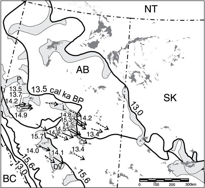
B

Dune activity and wind directions in relation to glacial limits and pro-glacial lakes (after Dyke et al., 2003) for (A) between 15.6 and 13.0 cal ka BP and (B) between 13.0 and 9.0 cal ka BP. Uncertainty in optical ages is about 7% at 1σ (see Table III for values). Solid arrows indicate dune-forming wind directions (derived from dune field orientations) with age control, and dashed arrows indicate orientations with inferred timing. Also labeled are glacial lakes Peace (P), Leduc (L), Drayton Valley (DV) and McConnell (M). Dashed line in Figure 4B denotes the southern and western limit of anticylonic winds.
Activité dunaire et direction des vents en relation avec les limites glaciaires et les lacs proglaciaires (d’après Dyke et al., 2003) pour (A) la période entre 15,6 et 13,0 ka cal. BP et (B) la période entre 13,0 et 9,0 ka cal. BP. La marge d’incertitude des âges optiques est de l’ordre de 7 % à 1σ (voir les valeurs au Tableau III). Les flèches pleines indiquent la direction des vents efficaces (dérivée de l’orientation des champs de dunes) avec des âges obtenus par datation et les flèches tiretées représentent l’orientation des vents avec les âges inférés. L’emplacement des lacs glaciaires Peace (P), Leduc (L), Drayton Valley (DV) et McConnell (M) sont aussi montrés. La ligne tiretée de la figure 4B représente la limite méridionale et occidentale des vents anticycloniques.
Outside the limit of anticylonic winds, dune-forming winds continued to originate from the west and northwest. Dune activity occurred in the Grande Prairie area (ca. 12.9 and 11.8 ka) and in the south (ca. 12.8, 12.5, 12.4, 12.0, 11.7, <11.6 and 11.3 ka), but dunes were fully stabilized by about 11 ka. The only exception is the Stony Plain area, southwest of Edmonton, where dune reactivation occurred at about 6.2 ka.
Dune actvity in relation to late Wisconsinan paleoclimate
As with the glacial chronology, the post-glacial sequence of paleoenvironmental change in western Canada has been a topic of some debate, due to the uneven distribution of study sites, limited early deglacial records and unreliable radiocarbon ages derived from non-woody organics, such as peat and gyttja (Beaudoin, 1993). Most paleoenvironmental interpretations from western Canada are derived from pollen or diatom records of lake cores (e.g. Hickman and Schweger, 1993, 1996; MacDonald, 1989; Vance, 1986), with additional data from macrofossil, peatland and vertebrate localities (Beaudoin et al., 1996; Wilson, 1996; Halsey et al., 1998). Dyke et al. (2004) describe and map the vegetation history of glaciated North America for 21.4 cal ka BP to present, and include 1000‑year BP time steps since 17.4 cal ka BP, based on an extensive compilation of published pollen, macrofossil and macrofaunal assemblages. The chronology of dune activity presented herein is discussed in context with this interpretation of paleo-vegetation distribution, for the interval between 15.6 and 9.0 cal ka BP.
15.6 to 13.0 cal ka BP
Between about 15.6 and 13.5 cal ka BP, the newly deglaciated terrain in western Canada must have been cold and intensely windy. Dunes dating to this period indicate that winds were from the northwest. Therefore, winds blowing off both the Cordilleran and Laurentide ice sheets were apparently funneled southward through this corridor, as ice blocked flow to the north. Katabatic winds carrying dry air probably created a cold-tundra periglacial environment, as reflected by the predominantly herb tundra vegetation at this time (Dyke et al., 2004). Cold-climate eolian processes were likely dominant at this time, in addition to possible stagnant ice and permafrost (Mandryk, 1996). It appears that glacial anticyclonic circulation, evident after 13.0 cal ka BP, was not present and may have been inhibited by winds blowing southward along the margins of the Laurentide and Cordilleran ice sheets.
As the Laurentide Ice Sheet retreated eastward between 13.5 and 13.0 cal ka BP, much of central Alberta previously occupied by tundra vegetation was replaced by parkland in the north and grassland in the south (Dyke et al., 2004). Continued dune activity in this area indicates that transporting winds were still strong and vegetation was, at least locally, sparse.
13.0 to 9.0 cal ka BP
By about 13.0 cal ka BP, dune fields in eastern Alberta were influenced by transporting winds from the southeast, which we infer were generated by glacial anticyclonic circulation. The limit of anticyclonic winds, as suggested by dune field orientations, is depicted in Figure 4B. Based on this interpretation, the influence of anticyclonic winds probably extended 200 km or less beyond the Laurentide Ice Sheet. Southwest of this limit, winds in central Alberta were from the west and northwest. Central Alberta was covered by parkland vegetation between 13.0 and 11.5 cal ka BP (Dyke et al., 2004), probably reflecting the moderating influence of a relatively warm Pacific air mass. Subsequent stabilization of sand dunes across most of this area appears to be coincident with the replacement of parkland vegetation by boreal forest after 11.5 cal ka BP (Dyke et al., 2004).
As the Laurentide Ice Sheet receded, anticyclonic circulation around the ice sheet receded with it. Dunes, active between 13.0 and 9.0 cal ka BP under anticylonic winds, were influenced by cold off-ice winds and formed in shrub tundra to forest-tundra environments (Dyke et al., 2004). These anticylonic winds were replaced, time transgressively, by winds probably associated with the eastward-migrating influence of the more moderate Pacific air mass. Sand dunes were modified by winds from the northwest, and boreal forest replaced tundra vegetation. Stabilization probably occurred as a result of reduced winds and increased vegetation cover.
Dune reactivation in the Stony Plain area at ca. 6.2 ka is consistent with eolian deposition inferred by Westgate (1970) for the Stony Plain area. It is also synchronous with other dune activity along the grassland-parkland boundary in central Saskatchewan, which may have occurred in response to increased aridity and reduced vegetation cover during the mid-Holocene (Wolfe et al., 2006).
Late Wisconsinan circulation
The concept of a cold-core anticyclone centred over the Laurentide Ice Sheet was conceptually proposed by Bryson and Wendland (1967), and subsequently modeled using AGCMs in the 1980s (Manabe and Broccoli, 1985; COHMAP Members, 1988). Anticylonic circulation around the perimeter of the ice sheet was generated by the Coriolis force, which causes air flowing away from a high pressure centre to be deflected in a clockwise direction in the northern hemisphere. Although support for an anticyclonic circulation pattern has been found from eolian features, evidence is mostly constrained to eastern North America (Thorson and Schile, 1995; French and Demitroff, 2001), and for later glacial positions (David, 1981a, 1988; Filion, 1987, Krist and Schaetzl, 2001). In contrast, evidence from loess deposits in the midcontinent indicates that winds south of the Laurentide Ice Sheet were predominantly northwesterly and westerly during full glacial conditions (Muhs and Bettis, 2000; Bettis et al., 2003).
This study provides a time constraint on glacial anticylconic circulation in western Canada. Dune field orientations indicate that anticyclonic circulation is first noted at about 13.0 cal ka BP (Fig. 4B). This circulation may have extended no more than about 200 km from the Laurentide Ice Sheet, as dunes west of this limit show no evidence of transporting winds from the southeast. Although it is possible that morphological evidence of anticyclonic winds was destroyed by later westerly or northwesterly winds, this appears unlikely as many dune fields to the northeast clearly retain records of multiple wind directions prior to stabilization (Fig. 4B; David, 1981a). In addition, dunes dating before and after ca. 13.0 ka in central Alberta record paleowinds only from the west or northwest (Fig. 4A‑B). These winds appear to have originated from air parcels funneled southward between the Cordilleran and Laurentide ice sheets.
Although AGCMs simulate a persistent glacial anticyclone between ca. 21 and 10 cal ka BP, surface winds were relatively weak along the southeastern margin of the ice sheet (Kutzbach et al., 1998). Kutzbach and Wright (1985) suggest that south of the ice sheet at ca. 21 cal ka BP the strong winds from the northwest (interpreted from the eolian geological record) may have been enhanced by the existence of a “sag” at the Rocky Mountain front at the junction of the Cordilleran and Laurentide ice sheets. This topographic low may have allowed the escape of cold Arctic air accumulating to the north (Bryson and Wendland, 1967), thus inhibiting the westward flow of anticyclonic winds. The ice was thin where the Laurentide and Cordilleran glaciers met (Little et al., 2001), and ice surface elevations in southwestern Alberta during the last glacial maximum were probably less than 1 500 m compared to greater than 3 000 m in the Rocky Mountains. Evidence from sand dunes for paleowinds from the northwest during early deglacial conditions (ca. 15.6 to 13.5 cal ka BP) in central Alberta lends further support to the hypothesis that winds during full-glacial conditions along the foothills may have been from the northwest.
The southwesterly limit of anticylconic winds (Fig. 4B) also closely parallels the present-day mean frontal position of the mild Pacific air mass in western Canada (Bryson, 1966), suggesting that the limit may be defined by the eastern extent of excursions of the Pacific air mass into western Canada at ca. 13.0 cal ka BP. The suggestion that the influence of Pacific air could extend nearly as far eastward during the Late Wisconsinan as it does today is certainly plausible. Pacific air must have entered the Cordillera during full-glacial conditions, as this would be the primary source of moisture-laden air responsible for snow and ice accumulation to form the Cordilleran Ice Sheet. In continuing eastward, moisture would be lost in the Cordillera and dry air would subsequently descend and warm, as it does today, providing little precipitation east of the Rockies. Consequently, ice at the confluence of the Laurentide and Cordilleran ice sheet was relatively thin. As the Laurentide Ice Sheet retreated, the frontal position of Pacific air mass would also extend eastward, until reaching its easternmost limit. Thus, glacial anticyclonic winds were not effectively generated in western Canada, and possibly western North America, until the Laurentide Ice Sheet was sufficiently east of the influence of westerly wind associated with the Pacific air mass (Fig. 4B).
As the Laurentide Ice Sheet retreated after ca. 13.0 cal ka BP, the extent of anticyclonic circulation retreated with it. This circulation probably extended farther from the ice sheet, and was stronger in winter than in summer as the polar front extending off the ice sheet was more dominant in winter (Bryson and Wendland, 1967; Kutzbach and Wright, 1985). The termination of anticyclonic circulation is probably closely connected in time with the collapse of the Laurentide Ice Sheet subsequent to 9.0 cal ka BP (Dyke et al., 2003).
Conclusions
This study provides the first dating control on dune activity within the most northerly portion of the northern Great Plains. Unlike those in other parts of the Great Plains, these stabilized dune fields are mostly relict phenomena of a Late Wisconsinan deglacial environment.
The key conclusions of this study are:
Dune activity in central Alberta occurred in an ice-proximal tundra setting along the deglaciated margins of the Cordilleran and Laurentide ice sheets between ca. 15.6 and 13.5 cal ka BP. Transporting winds were predominantly from the northwest, with katabatic winds funneled along the ice margins. Winds were probably also influenced, in part, by easterly incursions of Pacific air.
Anticylonic circulation with transporting winds from the southeast influenced dune activity starting at about 13.0 cal ka BP, after the Laurentide Ice Sheet had retreated sufficiently east of the influence of the Pacific air mass. Anticyclonic circulation likely extended no more than 200 km from the Laurentide Ice Sheet.
As the Laurentide Ice Sheet retreated northeastward, between 13.0 and 9.0 cal ka BP, the anticyclonic circulation retreated with it. Transporting winds from the southeast were successively replaced by winds from the west and northwest as Pacific air migrated eastward to its approximate present-day limit.
Dune fields across the region probably stabilized in a time-transgressive manner from central Alberta to northeastern Saskatchewan, between about 13.0 and 9.0 cal ka BP, as boreal forest covered the region.
Dunes in the Stony Plain area, southwest of Edmonton, reactivated during the mid-Holocene along with other dune fields in the present-day prairie parkland ecozone of western Canada (Wolfe et al., 2006).
Parties annexes
Acknowledgements
This study was supported by funds from the Geological Survey of Canada and the Science component of the Climate Change Action Fund. Field assistance by Zoe Pfeiffer and GIS assistance by Louis Robertson was greatly appreciated. S.A. Todd and H. Ruotsalainen are thanked for preparation and measurement of samples for optical dating. The manuscript benefited from reviews by David Fisher, Dan Muhs and Nat Rutter. This research was supported by the Geological Survey of Canada and by the Natural Science and Engineering Research Council of Canada. This paper is a Natural Resources Canada contribution to the Paleoenvironmental Records of Climate Change project of the Reducing Canada’s Vulnerability to Climate Change program.
Notes
References
- Ahlbrandt, T.S., Swinehart, J.B. and Maroney, D.G., 1983. The Dynamic Holocene Dune Fields of the Great Plains and Rocky Mountain Basins, U.S.A., p. 379‑406. In M.E. Brookfield and T.S. Ahlbrandt, eds., Eolian sediments and processes, Elsevier, Amsterdam, 660 p.
- Aitken, M.J., 1998. An introduction to Optical Dating. Oxford University Press, Oxford, 267 p.
- Beaty, C.B., 1975. Coulee alignment and the wind in southern Alberta, Canada. Geological Society of America Bulletin, 86 : 119‑128.
- Beaudoin, A.B., 1993. A compendium and evaluation of postglacial pollen records in Alberta. Canadian Journal of Archaeology, 17 : 92‑112.
- Beaudoin, A.B., Wright, M., Ronaghan, B., 1996. Late Quaternary landscape history and archaeology in the ‘ice-free corridor’: some recent results from Alberta. Quaternary International, 32 : 113‑126.
- Bettis, A.E. III, Muhs, D.R., Roberts, H.M. and Wintle, A.G., 2003. Last glacial loess in the conterminous USA. Quaternary Science Reviews, 22 : 1907‑1946.
- Bryson, R.A., 1966. Air masses, streamlines, and the boreal forest. Geographical Branch, 8 : 228‑269.
- Bryson, R.A. and Wendland, W.M., 1967. Tentative climatic patterns for some late glacial and post-glacial episodes in central North America, p. 271‑298. In W.J. Mayer-Oakes, ed., Life, Land and Water. Proceedings of the 1966 Conference on Environmental Studies of the Glacial Lake Agassiz Region. Department of Anthropology, University of Manitoba, Occasional Paper No. 1, University of Manitoba Press, 414 p.
- Carson, M.A. and MacLean, P.A., 1986. Development of hybrid aeolian dunes: the William River dune field, northwest Saskatchewan, Canada. Canadian Journal of Earth Sciences, 23 : 1974‑1990.
- Catto, N.R., 1983. Loess in the Cypress Hills, Alberta, Canada. Canadian Journal of Earth Sciences, 20 : 1159‑1167.
- Catto, N. and Mandryk, C., 1990. Geology of the postulated ice-free corridor, p. 80‑85. In L.D. Agenbroad, J.L. Mead and L.W. Nelson, eds., The Mammoth Site of Hot Springs, South Dakota. Scientific Papers, vol. 1. Hot Springs, South Dakota, 143 p.
- COHMAP members, 1988. Climate changes of the last 18,000 years: observations and model simulations. Science, 241 : 1043‑1052.
- David, P.P., 1977. The Brookdale road section and its significance in the chronological studies of dune activities in the Brandon Sand Hills of Manitoba; Geological Association of Canada; Special Paper No. 9, 293‑299.
- David, P.P., 1981a. Stabilized dune ridges in northern Saskatchewan. Canadian Journal of Earth Sciences, 18 : 286‑310.
- David, P.P., 1981b. The aeolian environment, p. B19‑B56, In Z.M. Abouguendia, ed., Athabasca Sand Dunes in Saskatchewan. Mackenzie River Basin Study Report, Supplement 7, Appendices A‑G, 335 p.
- David, P.P., 1988. The coeval eolian environment of the Champlain Sea episode, p. 291‑305. In N.R. Gadd, ed., The Late Quaternary Development of the Champlain Sea Basin. Geological Association of Canada Special Paper 35, 312 p.
- Dyke, A.S., Moore, A.J. and Robertson, L., 2003. Deglaciation of North America. Geological Survey of Canada, Ottawa, Open File 1574. 32 maps, CD‑ROM and 2 paper sheets.
- Dyke, A.S. and Prest, V.K., 1987. Late Wisconsinan and Holocene history of the Laurentide Ice Sheet. Géographie physique et Quaternaire, 41 : 237‑263.
- Dyke, A.S., Robertson, L. and Giroux, D., 2004. Paleovegetation maps of northern North America, 18 000 to 1000 BP. Geological Survey of Canada, Ottawa, Open File 4682.
- Filion, L., 1987. Holocene development of parabolic dunes in the central St. Lawrence Lowland, Quebec. Quaternary Research, 28 : 196‑209.
- Fisher, T. G., 1996. Sand-wedge and ventifact palaeoenvironmental indicators in northwest Saskatchewan, Canada, 11 ka to 9.9 ka BP. Permafrost and Periglacial Processes, 7 : 391‑408.
- Flemal, R.C., Odom, E.E., and Vail, R.G., 1972. Stratigraphy and origin of the paha topography of northwestern Illinois. Quaternary Research, 19 : 236‑248.
- Forman, S.L., Oglesby, R., and Webb, R.S., 2001. Temporal and spatial patterns of Holocene dune activity on the Great Plains. Global and Planetary Change, 29 : 1‑29.
- French, H.M. and Demitroff, M., 2001. Cold-climate origin of the enclosed depressions and wetlands (‘spungs’) of the Pine Barrens, Southern New Jersey, USA. Permafrost and Periglacial Processes, 12 : 337‑350.
- Goble, R.J., Mason, J.A., Loope, D.B., and Swinehart, J.B., 2004. Optical and radiocarbon ages of stacked paleosols and dune sands in the Nebraska Sand Hills, USA. Quaternary Science Reviews, 23 : 1173‑1182.
- Halsey, L.A. and Catto, N.R., 1994. Geomorphology, sedimentary structures, and genesis of dome dunes in western Canada. Géographie physique et Quaternaire, 48 : 97‑105.
- Halsey, L.A., Catto, N.R. and Rutter, N.W., 1990. Sedimentology and development of parabolic dunes, Grande Prairie dune field, Alberta. Canadian Journal of Earth Sciences, 27 : 1762‑1772.
- Halsey, L.A., Vitt, D.H. and Bauer, I.E., 1998. Peatland initiation during the Holocene in continental western Canada. Climate Change, 40 : 315‑342.
- Henderson, E.P., 1959. Surficial geology of Sturgeon Lake Map-Area, Alberta. Geological Survey of Canada, Ottawa, Memoir 303, 170 p.
- Hickman, M. and Schweger, C.E., 1993. Late glacial-early Holocene paleosalinity in Alberta, Canada ñ climate implications. Journal of Paleolimnology, 8 : 149‑161.
- Hickman, M. and Schweger, C.E., 1996. The Late Quaternary palaeoenvironmental history of a presently deep freshwater lake in east-central Alberta, Canada and palaeoclimate implications. Palaeogeography, Palaeoclimatology, Palaeoecology, 123 : 161‑178.
- Hopkins, D.G. and Running, G.L., 2000. Soils, dunes, and prairie vegetation: lessons from the sandhills of North Dakota. Prairie Forum, 25 : 45‑64.
- Huntley, D.J. and Lamothe, M., 2001. Ubiquity of anomalous fading in K‑feldspars, and the measurement and correction for it in optical dating. Canadian Journal of Earth Sciences, 38 : 1093‑1106.
- Huntley, D.J. and Lian, O.B., 1999. Using optical dating to determine when a mineral grain was last exposed to sunlight, p. 211‑222. In D.S. Lemmen and R.E. Vance, eds., Holocene Climate and Environmental Change in the Palliser Triangle: A Geoscientific Context for Evaluating the Impacts of Climate Change on the Southern Canadian Prairies. Geological Survey of Canada, Ottawa, Bulletin 534, 295 p.
- Krist, F. Jr. and Schaetzl, R.E., 2001. Paleowind (11,000 BP) directions derived from lake spits in Northern Michigan. Geomorphology, 38 : 1‑18.
- Kutzbach, J.E. and Wright, H.E. Jr., 1985. Simulation of the climate of 18,000 yr BP: results for the North American/North Atlantic/European Sector. Quaternary Science Reviews, 4 : 147‑187.
- Kutzbach, J.E., Gallimore, R., Harrison, S.P., Behling, P., Selin, R. and Laarif, F., 1998. Climate simulations for the past 21,000 years. Quaternary Science Reviews, 17 : 473‑506.
- Lemmen, D.S., Duk-Rodkin, A., and Bednarski, J.M., 1994. Late glacial drainage systems along the northwestern margin of the Laurentide Ice Sheet. Quaternary Science Reviews, 13 : 805‑828.
- Levson, V. and Rutter, N.W., 1996. Evidence of Cordilleran Late Wisconsinan glaciers in the ‘ice-free corridor’. Quaternary International, 32 : 33‑51.
- Lian, O.B. and Huntley, D.J., 2001. Luminescence dating, p. 261‑282. In W.M. Last and J.P. Smol, eds., Tracking Environmental Change Using Lake Sediments. Volume 1: Basin Analysis, Coring, and Chronological Techniques. Kluwer, Dordrect, 548 p.
- Lian, O.B., Huntley, D.J. and Wolfe, S.A., 2002. Optical dating of eolian dune sand from the Canadian prairies. Géographie physique et Quaternaire, 56 : 191‑202.
- Little, E.C., Jackson, L.E., James, T.S., Hicock, S.R. and Leboe, E.R., 2001. Continental/Codilleran ice interactions: a dominant cause of westward super-elevation of the last glacial maximum continental ice limit in southwestern Alberta, Canada. Boreas, 30 : 43‑52.
- Madole, R.F., 1994. Stratigraphic evidence of desertification in the west-central Great Plains within the past 1000 years. Geology, 22 : 115‑177.
- MacDonald, G.M., 1989. Postglacial palaeoecology of the subalpine forest-grassland ecotone of southwestern Alberta: new insights on vegetation and climate change in the Canadian Rocky Mountains and adjacent foothills. Paloegeography, Palaeoclimatology, Palaeocology, 73 : 155‑173.
- MacDonald, G.M., Beukens, R.P., Kieser, W.E., and Vitt, D.H., 1987. Comparative radiocarbon dating of terrestrial plant macrofossils and aquatic moss from the “ice-free corridor” of western Canada. Geology, 15 : 937‑840.
- Manabe, S. Broccoli, A.J., 1985. The influence of continental ice sheets on the climate of an ice age. Journal of Geophysical Research, 90 : 2167‑2190.
- Mandryk, C.A.S., 1996. Late Wisconsinan deglaciation of Alberta: processes and paleogeography. Quaternary International, 32 : 79‑85.
- Muhs, D.R. and Bettis, A.E. III, 2000. Geochemical variations in Peoria Loess of western Iowa indicate paleowinds of midcontinental North America during last glaciation. Quaternary Research, 53 : 49‑61.
- Muhs, D.R., Stafford, T.W., Jr., Swinehart, J.B., Cowherd, S.D., Mahan, S.A., Bush, C.A., Madole, R.F. and Maat, P.B., 1997. Late Holocene eolian activity in the mineralogically mature Nebraska Sand Hills. Quaternary Research, 48 : 162‑176.
- Muhs, D.R. and Wolfe, S.A., 1999. Sand dunes of the northern Great Plains of Canada and the United States, p. 183‑197. In D.S. Lemmen and R.E. Vance, eds., Holocene Climate and Environmental Change in the Palliser Triangle: a Geoscientific Context for Evaluating the Impacts of Climate Change on the Southern Canadian Prairies, Geological Survey of Canada, Ottawa, Bulletin 534, 295 p.
- Muhs, D.R. and Zárate, M., 2001. Late Quaternary eolian records of the Americas and their paleoclimatic significance, p. 183‑216. In V. Markgraf, ed., Interhemispheric Climate Linkages. Academic Press, New York, 454 p.
- Odynsky, W., 1958. U‑shaped dunes and effective wind directions in Alberta, Canadian Journal of Soil Sciences, 38 : 56‑62.
- Pfeiffer, Z.K. and Wolfe, S.A., 2002. Sand dune orientations in the Prairie provinces of Canada. Geological Survey of Canada, Ottawa, Open File 4117.
- Prest, V.K., 1969. Retreat of Wisconsin and Recent Ice in North America. Geological Survey of Canada, Ottawa, Map 1257A, scale 1:5 000 000.
- Raup, H.M. and Argus, G.W., 1982. The Lake Athabasca sand dunes of northern Saskathcewan and Alberta, Canada. 1. The land and vegetation; National Museum of Canada, Publications in Botany, 12, 96 p.
- Running, IV, G.L., Havholm, K.G., Boyd, M. and Wiseman, D.J., 2002. Holocene stratigraphy and geomorphology of Flintstone Hill, Lauder Sandhills, Glacial Lake Hind basin, southwestern Manitoba. Géographie physique et Quaternaire, 56 : 291‑303.
- Stokes, S. and Swinehart, J., 1997. Middle‑ and late-Holocene dune reactivation in the Nebraska Sand Hills, USA. The Holocene, 7 : 263‑272.
- St-Onge, D.A., 1972. Sequence of glacial lakes in north-central Alberta. Geological Survey of Canada, Ottawa, Bulletin 213, 16 p.
- Thorson, R.M. and Schile, C.A., 1995. Deglacial eolian regimes in New England. GSA Bulletin, 107 : 751‑761.
- Tremblay, L.P., 1961. Wind striations in northern Alberta and Saskatchewan, Canada. Geological Society of America Bulletin, 72 : 1561‑1564.
- Vance, R.E., 1986. Pollen stratigraphy of Eaglenest Lake, northeastern Alberta. Canadian Journal of Earth Sciences, 23 : 11‑20.
- Wallace, W.G., 2002. Evolution of Holocene eolian landscapes in the Glacial Lake Hind basin, Manitoba. Géographie physique et Quaternaire, 56 : 305‑313.
- Warren, A., 1976. Morphology and sediments of the Nebraska Sand Hills in relation to Pleistocene winds and the development of aeolian bed forms. Journal of Geology, 84 : 1271‑1286.
- Wells, G.L., 1983. Late-glacial circulation over central North America revealed by aeolian features, p. 317‑330. In A. Street-Peerot, M. Beran and R. Ratcliffe, eds., Variations in the Global Water Budget. Dordrecht, D. Reidel Publishing Co., 518 p.
- Westgate, J.A., 1970. The Quaternary geology of the Edmonton area, Alberta, p. 129‑151. In Proceedings of the Symposium in Pedology and Quaternary Research. University of Alberta Press, Edmonton, 218 p.
- Wilson, M.C. 1996. Late Quaternary vertebrates and the opening of the ice-free corridor, with special reference to the genus bison. Quaternary International, 32 : 97‑105.
- Wintle, A.G., 1997. Luminescene dating: Laboratory procedures and protocols. Radiation Measurements, 27 : 769‑817.
- Wolfe, S.A., 2001. Eolian Deposits in the Prairie Provinces of Canada. Geological Survey of Canada, Ottawa, Open File 4118. 1 map, CD‑ROM.
- Wolfe, S.A., Muhs, D.R., David, P.P. and McGeehin, J.P., 2000. Chronology and geochemistry of late Holocene eolian deposits in the Brandon Sand Hills, Manitoba, Canada. Quaternary International, 67 : 61‑74.
- Wolfe, S.A., Huntley, D.J., David, P.P., Ollerhead, J., Sauchyn, D.J. and MacDonald, G.M., 2001. Late 18th century drought-induced sand dune activity, Great Sand Hills, Saskatchewan. Canadian Journal of Earth Sciences, 38 : 105‑117.
- Wolfe, S.A., Huntley, D.J. and Ollerhead, J., 2002a. Optical dating of modern and late Holocene dune sands in the Brandon Sand Hills, southwestern Manitoba. Géographie physique et Quaternaire, 56 : 203‑214.
- Wolfe, S.A., Ollerhead, J. and Lian, O.B., 2002b. Holocene eolian activity in south-central Saskatchewan and the southern Canadian Prairies. Géographie physique et Quaternaire, 56 : 215‑227.
- Wolfe, S.A. Ollerhead, J., Huntley, D.J. and Campbell, C., 2002c. Late Holocene dune activity in the Duchess dune field, Alberta. Geological Survey of Canada, Ottawa, Current Research 2002‑B3, 8 p.
- Wolfe, S.A., Ollerhead, J., Huntley, D.J. and Lian, O.B., 2006. Holocene dune activity and environmental change in the prairie parkland and boreal forest regions of central Saskatchewan, Canada. The Holocene, 16 : 17‑29.
 10.7202/032975ar
Liste des figures
Figure 1
The northern Great Plains, showing dune fields (after Muhs and Wolfe, 1999; Muhs and Zárate, 2001 and Wolfe, 2001), extent of Wisconsin glacial ice (WGI) at ca. 21.4 cal ka (after Dyke et al., 2003), and relevant eolian studies. Shaded areas in boxes show regions where optical dating was used in the present study (SH = Sand Hills).
Sheyenne Delta dunes (Hopkins and Running, 2000)
Minot SH (Muhs et al., 1997)
Glacial Lake Hind Basin (Running et al., 2002; Wallace, 2002)
Brandon SH (David,1977; Wolfe et al., 2000; 2002a)
Cypress Hills (Catto, 1983)
Southwestern Alberta (Beaty, 1975)
Great SH region (Wolfe et al., 2001)
Duchess dune field (Wolfe et al., 2002c)
South-central Saskatchewan (Wolfe et al., 2002b)
Central Saskatchewan (Wolfe et al., 2006)
Stony Plain SH (Westgate, 1970)
Grande Prairie dune field (Halsey et al., 1990; Halsey and Catto, 1994)
Watino SH (Henderson, 1959)
Cree Lake moraine region (Tremblay, 1961; David, 1981a; Fisher,1996)
Athabasca Sand Dunes (Carson and Maclean, 1986; David, 1981b; Raup and Argus, 1982)
Alberta (Odynsky, 1958)
Les Grandes Plaines septentrionales, où la carte montre les champs de dunes (d’après Muhs et Wolfe, 1999; Muhs et Zárate, 2001 et Wolfe, 2001), l’étendue de la glaciation Wisconsinienne aux alentours de 21,4 ka cal. (d’après Dyke et al., 2003), et des études éoliennes pertinentes. Les surfaces grisées montrent les régions où l’on a eu recours à la datation optique pour cette étude (SH = Sand Hills).
A
B
C
Study area and surrounding region. (A) Glacial limits and pro-glacial lakes at 15.6, 13.0, 10.2 and 9.0 cal ka BP (after Dyke et al., 2003) and distribution of dune fields (after Wolfe, 2001). (B) Location of optical-dating samples collected from central Alberta. Dune orientations derived from Pfeiffer and Wolfe (2002) and this study. (C) Location of optical-dating sample collected from stabilized dune at Sandy Lake, NWT.
La région à l’étude et ses environs. (A) Limites glaciaires, lacs proglaciaires à 15,6, 13,0, 10,2 et 9,0 k cal. BP (d’après Dyke et al., 2003) et répartition des champs de dunes (d’après Wolfe, 2001). (B) Lieu de prélèvement des échantillons soumis à une datation optique dans le centre de l’Alberta. Orientations des dunes dérivées de Pfeiffer et Wolfe (2002) et de la présente étude. (C) Lieu de prélèvement d’un échantillon pour datation optique provenant d’une dune stabilisée à Sandy Lake, dans les Territoires du Nord-Ouest.
A
B
C
D
E
F
Characteristic dune fields of the Canadian northern Great Plains with optical dating sample locations (where relevant) and primary transporting wind directions (indicated by arrows) as derived from dune orientations. (A) Stabilized parabolic dunes, Pipestone Sand Hills near Grande Prairie. (B) Stabilized transverse dunes, Holmes Crossing Sand Hills near Whitecourt. (C) Stabilized parabolic dunes and blowouts, Stony Plain Sand Hills near Edmonton. (D) Stabilized parabolic dunes, Lac la Biche Sand Hills. (E) Stabilized parabolic dunes, Wood Buffalo Sand Hills near Hay River. (F) Stabilized parabolic dunes in northwestern Alberta indicating older transporting winds from the southeast and more recent transporting winds from the west-northwest.
Champs de dunes caractéristiques des Grandes Plaines septentrionales du Canada, avec les lieux de prélèvement des échantillons pour la datation optique, de même que les principales directions des vents efficaces établies à partir de l’orientation des dunes. (A) Dunes paraboliques stabilisées, Pipestone près de Grande Prairie, (B) Dunes transversales stabilisées, Holmes Crossing près de Whitecourt. (C) Dunes paraboliques stabilisées et creux de déflation, Stony Plain près d’Edmonton. (D) Dunes paraboliques stabilisées, Lac la Biche. (E) Dunes paraboliques stabilisées, Wood Buffalo Sand Hills près de la rivière Hay. (F) Dunes paraboliques stabilisées dans le nord-ouest de l’Alberta qui indique les vents efficaces du sud-est, plus anciens, et des vents efficaces de l’ouest-nord-ouest, plus récents.
A
B
Dune activity and wind directions in relation to glacial limits and pro-glacial lakes (after Dyke et al., 2003) for (A) between 15.6 and 13.0 cal ka BP and (B) between 13.0 and 9.0 cal ka BP. Uncertainty in optical ages is about 7% at 1σ (see Table III for values). Solid arrows indicate dune-forming wind directions (derived from dune field orientations) with age control, and dashed arrows indicate orientations with inferred timing. Also labeled are glacial lakes Peace (P), Leduc (L), Drayton Valley (DV) and McConnell (M). Dashed line in Figure 4B denotes the southern and western limit of anticylonic winds.
Activité dunaire et direction des vents en relation avec les limites glaciaires et les lacs proglaciaires (d’après Dyke et al., 2003) pour (A) la période entre 15,6 et 13,0 ka cal. BP et (B) la période entre 13,0 et 9,0 ka cal. BP. La marge d’incertitude des âges optiques est de l’ordre de 7 % à 1σ (voir les valeurs au Tableau III). Les flèches pleines indiquent la direction des vents efficaces (dérivée de l’orientation des champs de dunes) avec des âges obtenus par datation et les flèches tiretées représentent l’orientation des vents avec les âges inférés. L’emplacement des lacs glaciaires Peace (P), Leduc (L), Drayton Valley (DV) et McConnell (M) sont aussi montrés. La ligne tiretée de la figure 4B représente la limite méridionale et occidentale des vents anticycloniques.
Liste des tableaux
Table I
Sample locations and dune descriptions
Table II
Locations, sample depths, K, Th and U concentrations used for dosimetry, and water contents of sample
Sample depth beneath the ground surface used for calculation of the cosmic-ray dose rate.
K contents are from atomic absorption analyses. Average of K content of samples in surroundings collected 30 cm below and above the main sample.
Th contents are from neutron activation analyses.
U contents are from delayed neutron analyses.
Water content = (mass water)/(dry mineral mass); water content is the as-collected value expressed as a percentage, and is the mean of three samples.
Note: Rb contents were in the range of 15‑40 μg*g‑1.
Table III
Total dose rate (Ḋ), equivalent doses (De), and optical ages
Total Ḋ = Ḋc + Ḋα ,β ,γ, where Ḋα ,β ,γ is the dose rate due to α, β, γ radiation and Ḋc is the cosmic-ray dose rate.
Optical ages, not corrected for anomalous fading.
Fading rates calculated from data collected between 1.6 and 813 days (SFU‑O‑257 to 266), 223 days (SFU‑O‑267 to 281), or 346 days (SFU‑O‑159) after laboratory irradiation as described for method ‘b’ in Huntley and Lamothe (2001). An asterisk (*) after the value indicates the fading rate was measured for this sample; otherwise the fading rate used is assumed, based on value in this column for other samples from the same site with mineralogy expected to be similar.
Delay is the time between laboratory irradiation and equivalent dose measurements.
Optical ages, corrected for anomalous fading using the data listed in the previous two columns.
The nature of the scatter in the normalized dose-response data suggests that this sample contains grains that were not exposed to sufficient sunlight, and hence its age must be interpreted as an upper limit.
Notes: Past water content was assumed to be 5.0 ± 3.0% (95 % confidence) for all samples. Aliquots used for thermal transfer correction were given a redinfrared laboratory bleach.