
Abstracts
Abstract
This article presents the architecture at three Saqqaq sites in the Nuuk Fjord on the West Coast of Greenland. The focus is on the architecture: box hearths, an axial feature and a boulder hearth will be described and accounted for by figures and measurements. Attention will also be paid to the distribution of artifacts, since these configurations might complement the evidence from stone structures when estimating the limits of a specific dwelling. By positioning the structures in the landscape, it will be underlined that architecture is a part of the natural surroundings and vice versa.
Résumé
Cet article présente l'architecture de trois sites saqqaquiens du fjord de Nuuk sur la côte ouest du Groenland. En mettant l'accent sur l'architecture, nous décrirons à l'aide de figures et de mesures, des foyers en forme de boîte, un aménagement axial et un foyer fait avec des blocs. Notre attention se portera également sur la distribution des artefacts, puisque ces configurations peuvent compléter l'information sur les structures de pierres au moment d'évaluer les limites d'une habitation. En tenant compte de l'intégration des structures dans le paysage, nous démontrerons comment l'architecture fait partie de l'environnement naturel et vice versa.
Article body
Introduction and character of landscape
This article presents the architecture at three newly excavated Saqqaq sites in the Nuuk Fjord on the West Coast of Greenland (Figure 1). The sites are part of 10 Palaeo-Eskimo sites forming the base for my Ph.D. dissertation Mobility and Aesthetics. Palaeo-Eskimo style in the Nuuk Fjord of Greenland. The focus of this article will be on stone structures, i.e. the architecture of those Saqqaq sites. Architecture is the art of building, and, as Norwegian authority on architecture Christian Norberg-Schulz (1995: 8) expresses it: "Architecture is a 'usable' art in our lives. It includes everyday as well as festivities, and conceals a lot of secrets and puzzles." The Palaeo-Eskimo architecture seems at first to be very modest. This said, we could perhaps come a bit closer to the entire concept of architecture by taking into consideration that the latter consists not only of the settlements where people met and did business, but also of the natural surroundings: the present land and seascape (Jackson 1994; Norberg-Schulz 1995: 19; Tilley 1994). This is a very obvious fact when dealing with Palaeo-Eskimo architecture in the Nuuk Fjord area in Greenland.
The Nuuk Fjord is named after Nuuk, the capital of Greenland. It is more than 100 km long and about 5 km wide, and the difference between low and high tide is up to 5 m. Behind the fjord, in the inland, is the ice-cap, and the ice flows out into some of the inner reaches of the fjord. It breaks off and icebergs sail out into the fjord, where the tide eventually pushes them out to sea. Hence, the Nuuk Fjord environment is a world in constant motion and, especially during the summer, rich in contrasts: it is ebb and flow, sea and mountain, ice and flowers. Sometimes, it is full of sounds, and sometimes intensely quiet. In the fjord, you often see large groups of seals and the backs of the big whales. There is guillemot, long-tailed duck, eider and gull, and over the land are snow buntings, arctic loons and eagles. Caribou, arctic fox — and mosquitoes — can be seen, as well as the occasional spider, butterfly and bumblebee.
The three Saqqaq sites that will be described here are situated in Qussuk, the north-western part of the Nuuk Fjord, in localities called Narsaarsup nuua, Nuugaarsuk and Kikiallit nuuat (Figure 1). All of them are ca. 4,000 years old and the architecture represents the typical structures of this period of time in Greenland. This means the presence of an axial feature (Schledermann 1990: 42) also called "midpassage" (Maxwell 1985: 97), and of a box hearth filled, like a bird nest, with what in Greenlandic archaeology are called "boiling stones" or "cooking stones" (Appelt and Pind 1996; Jensen 1998; Kramer 1996: 75). Despite their name, the purpose of these stones probably was as much for heating the dwelling as for food preparation (Larsen and Meldgaard 1958: 35-36). Boiling stones here are not any "fire cracked rocks" but significant ones; more or less round and fist-sized (Figure 4; Gulløv 1983: 51)[1]. Besides describing the stone structures for each site, the article will also pay attention to the distribution of artifacts, since their configuration might complement the architecture when estimating the limits and the size of the dwellings.
Narsaarsup nuua
Narsaarsuup nuua ("headland of the great plain") consists of a plain that slopes towards a more than 100 m long sandy beach bordered towards the fjord by a low turf-covered foreland. The area has numerous pre-Christian graves and on the foreland there are several remains of summer tents (with turf rings) from the Thule culture (Gulløv 1983: 183-185). The Palaeo-Eskimo structures were found at the base of the foreland on a spot situated 4 m above sea level (asl). This location is protected from the northerly wind, below a wide cliff that is more than 5 m high.
Figure 1
The Nuuk and Qussuk fjords with Narsaarsuup nuua, Nuugaarsuk and Kikiallit nuuat (map by Mikkel Myrup)

Before the excavation, there was a small amount of crowberry and some Arctic birch growing on the spot, and towards the beach there were a few tufts of lyme grass and also a wide strip of light-grey lichens. The location presented no significant signs of what we were seeking, but a few head-size stones stuck up above the ground level. A small test pit revealed a flake of killiaq (silicified slate) and a couple of round fist-size stones with signs of fire. The excavation that followed covered about 16 m2. The profile was 10 cm deep and showed two different turf layers. Below them, there was a strip of sand, interrupted by a sooty, 1.5 cm thick, cultural layer on a layer of clay. The bottom consisted of gravelly sand. Two fireplaces were uncovered in the course of the work: a box hearth and an axial structure.
The architecture
The box hearth with its fallen edging stones could be limited to slightly more than 1 m2. The fire chamber measured roughly 50 cm by 60 cm and had been constructed with two by two stones in opposition to each other (Figure 2). One of these was a long flat stone, now cracked. The bottom of the fire chamber consisted of fine gravel and sand. At the northern part lay four flat stones on top of one another. They could originally have been a single piece, forming a 40 cm by 50 cm bottom plate in the hearth, but now broken and tossed aside by cultural and/or natural post-depositional processes. The box hearth included more than 80 boiling stones. Some 30 were located in the box itself while others were found within 0.5 m from its outside. Most of them lay to the north and might have been subject to the same post-depositional processes that broke the bottom piece.
The axial structure was a little more then 2.5 m long oriented towards the sandy beach and the foreland (Figure 3). On the south side it had an unbroken row of seven stones. These were larger than head size and closely set. On the north side were four stones of the same kind, but set with more space between them. At one point where this row was broken, there was a long, flat cracked stone, measuring 70 cm long by 25 cm wide and 6 cm deep, now laying 20 cm outside the row.
The inside of the axial structure was 40 cm wide and divided into three spaces. Two of these were also 40 cm long, while the third measured up to 60 cm. The square area in the middle of the axial feature contained slightly more than one litre of charcoal and soot. It was filled by a cracked, flat and nearly square stone affected by fire. There was also some charcoal and flat stones in the western area. Some 60 boiling stones were counted, in and around this structure. Many were very brittle and they fell to pieces when lifted, just like many of the boiling stones from the box hearth did.
Artifacts distribution and interpretation of structures
In conjunction with the box hearth, very few finds were made: two burins, some fakes of quartzite, some small flakes of killiaq, and two of chalcedony. At the axial structure, there were more finds which included a notable number of cores of quartz crystal. There was also some projectile points, burins, burin spalls, and a few scrapers (Table 1). The raw materials used were killiaq, quartz crystal, quartz, quartzite and chalcedony. Much of the artifacts had been affected by fire and soot. The principal location of the artifacts was on the north side of the axial structure (Figure 3). Almost all the points lay there, as did the majority of the burin spalls and the greatest concentration of killiaq flakes — 140 of them in a single heap. However, the largest number of quartz crystal cores were found, together with a scraper, on the smallest side of the structure, towards the beach.
Figure 2
Plan drawing of Narsaarsup nuua: A) bunk side, B) axial structure, C) limit of distribution of finds, D) box-hearth. Excavated units are 1 m2 (drawing by the author).

At the excavation area, there were other flat and some burnt stones, which can have belonged to the hearths described above, but they can just as well have been part of other structures that probably exist in the proximity. The cultural layer increased somewhat in the southwest area. The denser growth in vegetation in that same area indicates that there might be a midden. If the middens of Palaeo-Eskimos where located in the same way as those of more recent Greenlanders, that is, in front of the entrance (Grønnow and Meldgaard 1991: 20, 116), the entry of the axial structure, and the opening to a possible tent, could lie where the scraper and the quartz crystal cores were found, i.e. with a view towards the beach and the foreland. Here, by the entrance, they might have had a work platform, constructed of the flat stones that lay in that part of the axial structure.
On the opposite side, to the southeast, a particularly interesting find was made right on the outside of the axial structure. It was a head-size stone, of a lesser sort of green soapstone. The stone is clearly worked, and has an oval cavity 18 cm long by 11 cm wide and 2 cm deep (Figure 6). This was probably a lamp or a lamp support that was placed furthest into the dwelling.
No stones can be identified with certainty as forming a tent ring, a floor or a bunk in this dwelling. On the south side, however, along the structure and approximately 60 cm from the unbroken row of stones, there was a 100 cm long, 20 cm high and 30 cm wide stone. Between this large stone and the axial structure, the area was empty of artifacts. If the people had their bunk, or sleeping area, there, it measured approximately 150 cm by 60 cm (Figure 2).
Whether the box hearth and the axial structure were part of the same dwelling or dwelling system is difficult to say. It could be a matter of an outdoor and an indoor hearth in the same dwelling system or of two completely independent structures. The charcoal datings differ somewhat but they also overlap. A charcoal sample from the box hearth (AAR-5588) gave a radiocarbon date of 2010-1835 B.C. (1935-1920 cal B.C. at 1 sigma), while a charcoal sample from the axial structure (AAR-5589) was dated 2030-1885 B.C. (1945 cal B.C. at 1 sigma).
The distance between the center of the box hearth and that of the axial structure is 2 m. If both hearths were part of the same dwelling, the diameter in a more or less round tent should be at least 5 m and the living area was therefore about 19 m2[2]. However, if we base our interpretation on the axial structure and to a possible "wall effect" (Grøn 2000: 177), explaining the artifacts distribution and the big stone on the bunk side, the dwelling's interior was limited to about 3 m by 2.75 m. Hence, the living area might have been just up to 7 m2[3].
Table 1
Finds from Narsaarsup nuua (KNK 24)

* for tool manufacture, ** includes fragments and possible burin spalls, *** soapstone
Nuugaarsuk
Nuugaarsuk is a foreland forming a bay at the mouth of the Qussuk Fjord. It consists of several plateaus. On the lowest of these there are a hunting cabin and several more or less recent ruins. Around the landscape there are well-preserved Christian and pre-Christian graves as well as numerous fox traps. In our survey, we found traces of Palaeo-Eskimo on the shorelines towards the fjord, but the site that was excavated is situated much higher up in the landscape; on a plateau 11 m asl.
The site lies above the steep mountainside on the northeast side of the bay, separated from it by a more than 15 m long and 1 m high cliff. To the west there is a large sloping open area while the east side is more rocky. The entire plateau is 250 m by 20 m, and vegetation includes crowberry, willow, arctic birch, bilberry and marsh tea. The reason why this particular plateau was searched extra carefully was the top of a triangular and completely white piece of quartz that stuck up from the ground. After making a test pit beside this white stone, we found indications of Palaeo-Eskimo presence in the form of three very small flakes of killiaq and quartz crystal together with fat black earth and some charcoal. The white stone was therefore assumed to be part of a hearth, which the excavation confirmed. When it was completed, the excavated area covered just over 16 m2 and another hearth had also been found. The vertical profile of the excavated area had a depth of 15 cm and beneath the surface was humified turf resting on a layer of light, clayey silt or fine sand. Below this was a black cultural layer, which adjacent to the two hearths, contained plenty of charcoal. At the bottom were pebbles and gravel.
The architecture
Two different hearths were found at the site. The one with the white quartz stone, which was in the western area, was constructed almost in the form of a ring, with four or five large round boulders, up to 50 cm by 20 cm. The fire chamber measured approximately 35 cm by 40 cm. It contained about 20 boiling stones and a thick layer of charcoal. The white stone turned out to be 30 cm long, with one large flat side and one rounded off. It showed no traces of fire, although it lay in the middle of the hearth.
The other hearth was a box built of flat stones (Figure 4). The largest side stone was 55 cm long, 23 cm wide and up to 2 cm thick. It was fallen on the south side of a square flat stone 40 cm long, 35 cm wide and 4 cm thick. On and beside this stone there were four other flat pieces, which could previously have formed just two stones. All these stones were completely covered by a dry white powder, similar to the ash that one gets after burning turf. There was also more than two litres of charcoal in this hearth. The box hearth contained approximately 30 boiling stones. This hearth was easy to reconstruct. The longest stone just had to be raised up from where it lay, and then, with the square stone as the bottom, it formed the inside of a 45 cm by 35 cm box. The purpose of the smaller flat stones is less clear. They could have formed some kind of "baking plates" in the hearth, or they could have been part of the walls inside the latter, supported by the adjacent, more rounded and less characteristic, stones.
In addition to the hearths, another structure could be detected in the excavated area, 170 cm north of the box hearth. It was a nearly oval stone formation, consisting of six head-size stones that lay partially on and around a flatter, 30 cm by 30 cm big stone. Just outside these stones was a couple of larger stones which emphasized the oval shape. This structure was completely devoid of finds.
Artifact distribution and interpretation of structures
In total there were some 30 tools or tool fragments, including burin spalls (Table 2). Weapon points and flakes formed no particular pattern; rather they lay spread over the entire area, while the only knife that was found lay on the east side of the box hearth. The clayey layer of the excavation area concealed a number of large concentrations of debitage, more than 200 in one for instance.
It is difficult to say if the boulder hearth and the box hearth at Nuugaarsuk are contemporaneous. The radiocarbon age of a charcoal sample from the boulder hearth with the white quartz stone (AAR-5587) was 2135-1960 B.C. (2030 cal B.C. at 1 sigma) and the charcoal sample from the box hearth (AAR-7801) was 2398-2202 B.C. (2289 cal B.C. at 1 sigma). It is a big difference in dates. This said, the charcoal from the boulder hearth consisted of very small pieces that probably were willow, while the charcoal from the box hearth consisted of bigger pieces, which indicates that these were of driftwood. Hence, considering the age of the driftwood, the hearths could be contemporaneous.
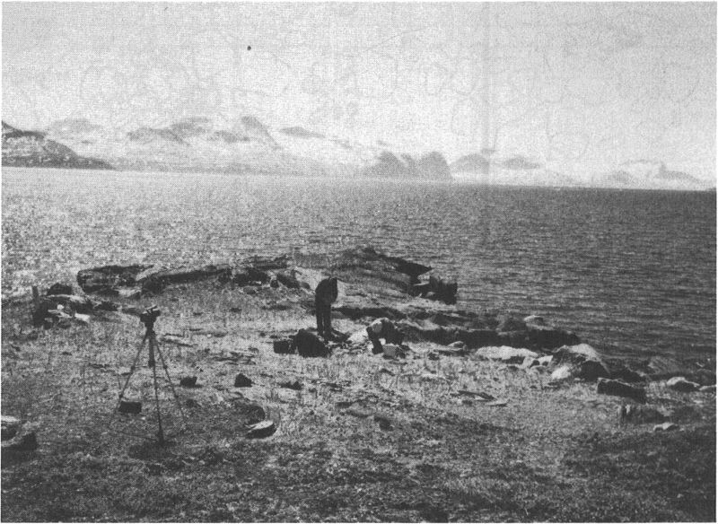
Figure 3
The axial structure at Narsaarsup nuua after excavation (photo by the author)

Figure 4
The box hearth at Nuugaarsuk (drawing by Frederik Fuuja Larsen)

The two hearths lay 3 m from one another (Figure 5). Based on the location of the finds, the hearth belong to separated structures. It is possible to delimit a 3 m2 living area (175 cm by 175 cm) between the box hearth, an oval stone formation to the north and stones in the northwestern part of the excavation. The finds indicate a possible "wall effect" since the number of artifacts increases noticeably in the area 1 m to the east of the hearth with the white quartz stone, and down towards the box hearth. If the box hearth was centrally positioned in the dwelling, these 3 m2 make up approximately 20% of it, which makes it reasonable to assume a total dwelling area of around 14 m2[4].
Table 2
Finds from Nuugaarsuk (KNK 23)

* for tool manufacture
Kikiallit nuuat
Kikiallit nuuat is a 70 m long and up to 50 m wide foreland that rises 4 m asl (Figure 7). It is situated right opposite to Nuugaarsuk at the entry to the reindeer hunting ground at Akia. The only signs of recent human activity here are two fox traps. The area investigated lies at the end of the foreland, and it consists of a 8 m by 10 m area covered with light sandy gravel with a sparse covering of grass and lyme grass. It is framed by a black bedrock containing lots of mica and white quartz and it is bordered towards the fjord by a cliff about 70 cm high. A system of test pits was arranged on each side of a 10 m long line. Just below the surface of these were found three killiaq burins, a bifacial point of white quartz, a small charcoal and a couple of fist-size stones, brittle from fire. The ensuing excavation covered 17 m2.
Figure 5
Plan drawing of Nuugaarsuk: A) boulder hearth, B) box hearth, C) the possible depot, D) limit of distribution of finds. Excavated units are 1 m2 (drawing by the author).
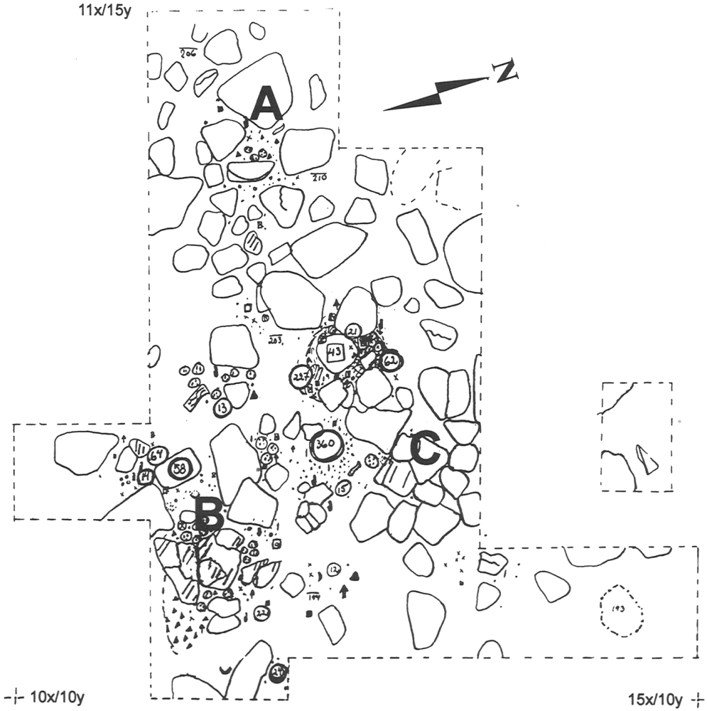
Figure 6
The lamp or lamp support at Narsaarsup nuua (photo by the author)

Figure 7
The foreland of Kikiallit nuuat (photo by the author)
The bedrock at Kikiallit is porous and thin; sheet-like stones are spread all around in the sandy gravel. The sand and all the cracked stones made it difficult to locate a sizeable stable profile, but the stratigraphy under one of the flat stones at the centre of the excavation area described a 10 cm high profile. The latter had at the top a layer of coarse grey-black sand, and beneath it was a 3-4 cm thick powdery layer resting on a burnt layer up to 5 cm thick containing fine soot and charcoal. The bottom consisted of gravelly sand.
The architecture
The analysis of this dwelling is complicated due to the porous sheet-like bedrock. Many of the stones were cracked and others were so brittle that they broke when lifted up. This also applies to stones that were not brittle from fire, but that had probably broken for natural reasons. However, there were also heavier, flat and intact stones. Several of them had clear signs of fire. Some were rectangular (one 60 cm long, 10 cm wide and 5 cm thick, another 50 cm long, 25 cm wide, 6 cm thick) and others were more square (e.g., 35 cm long, 40 cm wide, and 5 cm thick). Most of these were found within a 1.5 m by 3 m large area with the long dimension in direction southwest-northeast (Figure 8). If these stones correspond to an axial structure, it could be reconstructed as being 3 m long with an inside width of about 50 cm, divided into three rooms of which the two to the east have been hearths. Here there was about two litres of charcoal and the greatest concentration of boiling stones was in the centre of this area. The number of these was between 60 and 70.
One alternative to an axial structure is that there had been a shorter feature, around 175 cm long, and consisting principally of two box hearths built together. In both cases, the finds of small flat stones indicate a chip-covered floor in the western part of a dwelling that could have been about 10 m2 big[5]. Another alternative is that Kikiallit had been visited temporarily several times. Some of the stones could then have been re-used in new hearths. If one imagined that all the fire-affected, large, flat and square stones were cooking plates or bottoms in various box hearths, one could deduce that there could have been more than five of these boxes.
Artifact distribution and interpretation of structures
Some of the finds appeared directly underneath the surface. These were a transversal scraper, small bifacial points and burin spalls, as well as charcoal, soot, boiling stones and flat stones. Some of the stones were brittle and broken, and covered with a white coating which looked like turf ash. Below this were more tools, charcoal, flat stones, and a clayey layer up to 6 cm thick. The completely excavated area (Figure 8) was more or less covered by flat, large or small, stones. At the end of the excavation, the floor was chip-covered with soot and fine ash strewn over it. A charcoal sample (AAR-6605) was dated at 2025-1885 B.C. (1945 cal B.C. at 1 sigma).
Figure 8
Plan drawing of Kikiallit nuuat: A) hearth, B) bunk side, C) limit of distribution of finds. Excavated units are 1 m2 (drawing by the author).

Most of the stones found in the excavation were flat, but there were also some rounded and head-sized stones that could have been part of a tent ring, bordered by the low bedrock. However, if one looks at the distribution of tools, there is no obvious "wall effect." Most of the finds were made within a 3 m2 area on the southwest side of, and at right angles to, the axial line suggested above. Burins, projectile points and tool fragments were evenly divided between east and west, and there were concentrations of killiaq debitage in this entire area (Table 3). Most of the finds are of killiaq, a few are of quartzite, and in addition there was one microblade, three cores, two scrapers and a burin of quartz crystal. The microblade lay in the northern part of the find area, and the cores at the western extremity, while the scrapers and the burin were at the east side, as were two flakes of chalcedony. If what was recorded were the remains of an axial structure, the total finds are equally divided on each side of it.
However, based on the fact that the ground slopes to the southwest, and considering what the climatic and geophysical processes might have accomplished here over more than 3,000 years, it is possible that the stone structures and the artifacts might have shifted somewhat relative to their original position. From this perspective, the distribution of the finds supports the interpretation of the dwelling with a box hearth that has fallen out towards a chip-covered floor (Jensen 1998: 66), and moved charcoal, ash and boiling stones out across the activity area of the dwelling. No matter if it was organized with a box hearth or with an axial structure, the dwelling would be out of the wind and out of view behind the 1 m high cliff, and, with the entrance towards the water, it would still be possible to overlook the fjord.
Table 3
Finds from Kikiallit nuuat (KNK 134)

* for tool manufacture, ** handle core, *** transversal scrapers, **** sidescrapers
Conclusion
The three Saqqaq sites in the Nuuk fjord presented here have several features in common, but they also differ in some ways. According to the height of the sea level as well as to topography, they are located differently: two are on the height of 4 m asl, and one on 11 m asl; one is on the nose of a foreland, another at the base of a foreland, and the third on a plateau at the long side of a bay. The charcoal datings indicate that all the sites are about 4,000 years old, but that the one at the highest level is the oldest one.
The sites were all protected behind a low or a higher cliff, and the basis for the architectural structures on all of them was the box hearth. This was built as an independent fireplace, or as a part of an axial feature. Among other stones, one of the walls in every box was a very large and thin flagstone, about 60 cm long and between 2 and 4 cm thick. As a bottom plate they had one flat, square to rounded, stone. The amount of boiling/heating stones in each hearth varied between 20 and 80 pieces. A lamp-stone was "furnishing" one of the sites, and at another there was a construction interpreted as a depot or a post-hole.
Two of the sites had two fireplaces each which could have been part of two separate habitations or represent inside and outside hearths. There were no stones clearly pointing to tent rings, but the distribution of the finds may indicate a so-called "wall effect" at the same two sites. The estimated living areas in these dwellings are from less than 10 and up to 14 m2, taking into account a possible "wall effect" and just one hearth in each dwelling.
When compared to the dwellings at Nuunnguaq, the only Saqqaq site in the Nuuk Fjord district for which information on tent rings has been published (see Appelt and Pind 1996), the estimated size of the living area differs considerably. The three sites presented here are much smaller. At Nuunnguaq the structure diameter is estimated to be between 4.5 m and 6 m which gives an approximate area of 20 to 25 m2 (ibid.: 131). However, looking at tent rings higher up on the West Coast of Greenland, one finds that their diameter normally vary within the range of 3.5 to 5.5 m (Olsen 1998: 106). This means that the living area in a Saqqaq dwelling usually ranges between 9 to 24 m2, and that "our" dwellings therefore fit the figures.
The size estimates of dwellings documented in this article might be limited by the excavation areas, but might also be affected by the disturbing of stones from natural and cultural formation processes (Schiffer 1987). Many of the stones were cracked and this made it sometimes difficult to determine both their size and function. Some of the cracked, thin and flat stones might have been part of the inner wall of a double-walled fire chamber, or they could have been functioning as a "baking-plate" or as a lid on the top of the box. These kinds of questions (Knuth 1967: 45-56), as well as issues relating to the "wall effect" vis-à-vis the opposite "centre effect"; the practical vis-à-vis ideological use of the structures (Odgaard 1998); the possible seasonality (e.g., Hansen and Jensen 1991: 94); the general function of the sites and their possible reciprocal relations (Binford 1983; Tilley 1994: 35-67) are subjects too extensive for an article focusing on the architectural structures as such. They will however be discussed in my coming dissertation about the Palaeo-Eskimo culture in the Nuuk Fjord of Greenland.
Appendices
Acknowledgements
I am profoundly grateful to the board of the Greenland Directorate for Culture, Education, Research and Church that made it possible for me to participate to the symposium "Palaeoeskimo Architecture: State of Knowledge" in Saint-Pierre et Miquelon in 2002.
Notes
-
[1]
For further discussion on the use of "boiling stones" in Saqqaq context, see Olsen (1998: 112-115), and for their use in general, see Odgaard (2001).
-
[2]
The area of a circle is 78.54% of a quadrate (Jørgensen 1957: 487); 5 m x 5 m x 0.7854 = 19.6 m2.
-
[3]
Based on the following calculation: 3 m x 2.75 m x 0.7854 = 6.48 m2.
-
[4]
Based on the following calculation: 4.5 m x 4.0 m x 0.7854 = 14.13 m2.
-
[5]
Based on the following calculation: 4 m x 3 m x 0.7854 = 9.42 m2.
References
- APPELT, Martin and John PIND, 1996 Nunnguaq – A Saqqaq Site from the Godthåbsfjorden, in Bjarne Grønnow and John Pind (eds), The Paleo-Eskimo Cultures of Greenland. New Perspectives in Greenlandic Archaeology, Copenhagen, Danish Polar Center, Danish Polar Center Publication, 1: 129-142.
- BINFORD, Lewis, 1983 The Archaeology of Place, in Lewis Binford, Working at Archaeology, New York, Academic Press: 357-378.
- GRØN, Ole, 2000 Analyse af flintspredninger på stenalderbopladser, in Berit Valentin Eriksen (ed.), Flintstudier, Aarhus, Aarhus Universitetsforlag: 157-186.
- GRØNNOW, Bjarne and Morten MELDGAARD, 1991 De første vestgrønlaendere, Tidsskriftet Grønland, 1991(4-7): 103-141.
- GULLØV, Hans Christian, 1983 Nuup kommuneani qangarnitsanik eqqaassutit inuit-kulturip nunaqarfii –Fortidsminder i Nuuk kommune-inuit-kulturens bopladser, Nuuk, Kalaallit Nunaata Katersugaasivia and Nationalmuseet.
- HANSEN, Keld Møller and Jens Fog JENSEN, 1991 Orpissooq – en sommerfangstplads fra Saqqaq-kulturen, Tidsskriftet Grønland, 1991(4-7): 181-190.
- JACKSON, John Brinckerhoff, 1994 A Sense of Place, a Sense of Time, New Haven, Yale University Press.
- JENSEN, Jens Fog, 1998 Dorset dwellings in West Greenland, Acta Borealia, 15(2): 59-80.
- JØRGENSEN, Wilhelm, 1957 Den store regnebog, Copenhagen, Forlaget Ivar.
- KNUTH, Eigil, 1967 Archaeology of the Musk-Ox Way, Paris, École Pratique des Hautes Études, Contributions du Centre d'études arctiques et finno-scandinaves, 5.
- KRAMER, Finn Erik, 1996 Akia and Nipisat I: Two Saqqaq sites in Sisimiut District, in B. Grønnow and J. Pind (eds), The Paleo-Eskimo Cultures of Greenland. New Perspectives in Greenlandic Archaeology, Copenhagen, Danish Polar Center, Danish Polar Center Publication, 1: 65-96.
- LARSEN, Helge and Jørgen MELDGAARD, 1958 Paleo-Eskimo Cultures in Disko Bugt, West Greenland, Meddelelser om Grønland, 161(2).
- MAXWELL, Moreau, S., 1985 Prehistory of the Eastern Arctic, Orlando, Academic Press.
- NORBERG-SCHULTZ, Christian, 1995 Stedskunst, Oslo, Gyldendal Norsk Forlag.
- ODGAARD, Ulla, 1998 The Arctic Midpassage and its Religious Aspects, in A. Anderson et al. (eds), The Kaleidoscopic Past, Gøteborg, Gotarc Serie C, 16: 462-468.
- ODGAARD, Ulla, 2001 Ildstedet som livscentrum. Aspekter af arktiske ildsteders funktion og ideologi, Ph.D. dissertation, Aarhus, Aarhus University, Department of Prehistoric Archaeology, Medieval Archaeology, Ethnography and Anthropology.
- OLSEN, Bjørnar, 1998 Saqqaq housing and settlement in southern Disko Bay, West Greenland, Acta Borealia, 15(2): 81-128.
- SCHIFFER, Michael, 1987 Formation Processes of the Archaeological Record, Albuquerque, University of New Mexico Press.
- SCHLEDERMANN, Peter, 1990 Crossroads to Greenland, Calgary, Arctic Institute of North America, Komatik Series, 2.
- TILLEY, Christopher, 1994 A phenomenology of landscape. Places, paths and monuments, Oxford, Berg.
List of figures
Figure 1
The Nuuk and Qussuk fjords with Narsaarsuup nuua, Nuugaarsuk and Kikiallit nuuat (map by Mikkel Myrup)
Figure 2
Plan drawing of Narsaarsup nuua: A) bunk side, B) axial structure, C) limit of distribution of finds, D) box-hearth. Excavated units are 1 m2 (drawing by the author).
Figure 3
The axial structure at Narsaarsup nuua after excavation (photo by the author)
Figure 4
The box hearth at Nuugaarsuk (drawing by Frederik Fuuja Larsen)
Figure 5
Plan drawing of Nuugaarsuk: A) boulder hearth, B) box hearth, C) the possible depot, D) limit of distribution of finds. Excavated units are 1 m2 (drawing by the author).
Figure 6
The lamp or lamp support at Narsaarsup nuua (photo by the author)
Figure 7
The foreland of Kikiallit nuuat (photo by the author)
Figure 8
Plan drawing of Kikiallit nuuat: A) hearth, B) bunk side, C) limit of distribution of finds. Excavated units are 1 m2 (drawing by the author).
List of tables
Table 1
Finds from Narsaarsup nuua (KNK 24)
* for tool manufacture, ** includes fragments and possible burin spalls, *** soapstone
Table 2
Finds from Nuugaarsuk (KNK 23)
* for tool manufacture
Table 3
Finds from Kikiallit nuuat (KNK 134)
* for tool manufacture, ** handle core, *** transversal scrapers, **** sidescrapers