
Abstracts
Abstract
This paper presents a detailed description of the architectural elements associated with a Late Dorset semi-subterranean structure at the Bell site (NiNg-2), located on the Ekalluk River, southeastern Victoria Island, Nunavut. The 2002 excavation of the house centred on the recovery of detailed information relating to the architectural tradition of the Late Dorset in this area. The structural remains associated with House 6 suggest it was intended for only a short period of occupation that corresponded with the late fall caribou migration through the area. Probably abandoned during the early winter, House 6 is best interpreted as a "between seasons" structure, comparable to the Thule and historic Inuit qarmat.
Résumé
Cet article présente une description détaillée des éléments architecturaux d'une structure semi-souterraine du Dorsétien récent localisée au site Bell (NiNg-1), sur la rivière Ekalluk, au sud-est de l'île Victoria au Nunavut. La fouille de cette maison en 2002 avait pour but d'amasser de l'information concernant la tradition architecturale du Dorsétien récent dans cette région. Les vestiges structuraux associés à la Maison 6 suggèrent qu'elle fut conçue pour n'être occupée que pendant une courte période durant la migration de fin d'automne des caribous dans cette région. Probablement abandonnée au début de l'hiver, la Maison 6 est interprétée comme une structure “entre deux saisons” comparable aux qarmat des Thuléens et des Inuit de la période historique.
Article body
Introduction
This paper presents the results of excavations carried out during the 2002 field season of the Iqaluktuuq Project at the Bell site (NiNg-2), situated on the southern shore of the Ekalluk River, approximately 50 km northwest of Cambridge Bay, Victoria Island (Figure 1). The location of the site is unquestionably linked to the resources and topography of the Ekalluk River, the only viable north-south caribou crossing point between Ferguson Lake (which measures approximately 75 km from west to east) and Wellington Bay. As such, this 3 km long waterway is a natural point of convergence for caribou herds moving from northern Victoria Island to the Arctic mainland in the fall. These herds appear to have been a key economic resource, as indicated by the preponderance of caribou in the Late Dorset faunal assemblage from the Bell site (Friesen 2002: 340-341). Other utilized species identified during the 2002 field season include arctic char, whose large spawning run in the late summer and early fall gives the river its traditional name of Iqaluktuuq, or "place of many char" (Friesen 2000: 3), a variety of migratory waterfowl, as well as muskox and a small amount of seal.
Archaeological work in 2002 was directed towards the recovery of architectural details from one Late Dorset semi-subterranean dwelling, House 6, in order to better understand the Late Dorset building tradition in this area. This information forms a component of a larger study that is focussed on defining the range of stylistic variability present in Late Dorset architecture throughout the Arctic and, subsequently, to determine how a variety of factors (including the environment, culture, function, and temporal change) may have influenced house form. However, given the focussed nature of this volume, my paper will be restricted to a detailed report and discussion of the architectural remains from House 6 at the Bell site.
The Bell Site (NiNg-2) and House 6
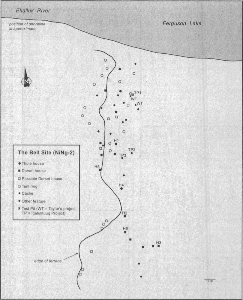
The Bell site is located on a gently sloping southeasterly-facing grassy terrace, between 5 and 7 m above the lake' s shoreline (14-16 m above sea level), and has an unobstructed view of the head of Ferguson Lake. Bell is one of a series of sites identified in 1963 by William E. Taylor, Jr., who returned to the Ekalluk area in 1965 and 1988, during which time several Late Dorset and Thule houses were investigated (Taylor 1964a, 1967, 1988). The site was revisited in 2001 as part of the Iqaluktuuq Project (Friesen 2002), and House 6 was excavated in 2002 as a component of this renewed research activity. Surficial evidence of human occupation at the site includes Late Dorset, Thule, and historic Inuit, as indicated by the presence of rectangular and circular house depressions, caches, and modern tent rings with associated cultural materials. Establishing the number of structures at the site is complicated by surface vegetation (grass, dwarf willow, and moss) and the multi-component nature of the site. Nonetheless, it appears that at least eleven Late Dorset and six Thule houses were constructed at the site (Figure 2), in addition to numerous late prehistoric and historic tent rings and caches (Friesen, pers. comm. 2002). Although a substantial Early Dorset occupation has not been identified at Bell, Taylor (1967: 223) suggested it may also be represented on the basis of several diagnostic Early Dorset artefacts, a possibility supported by the recovery of additional material during our excavations.
Figure 1
Map showing the location of the Ekalluk River and the Bell site. The river, which flows westward into Wellington Bay, functions as a natural funnel for migrating caribou.

Figure 2
Map of the Bell site, showing the location of House 6 in relation to the other features (map: courtesy of T. M. Friesen)
The Late Dorset structures at the Bell site can be divided into two basic depression types; semi-rounded and relatively deep, and sub-rectangular and shallow, each of varying sizes. Both structural types are typically distinguished by relatively richer vegetation in their interiors, although neither dwelling type possesses well-defined exterior wall contours. House 6, of the shallow sub-rectangular type (Figure 3), was chosen for excavation because it appeared to have been unaffected by previous research activity, and because of its distance from the main area of Thule activity. Preliminary surface observations indicated the structure measured approximately 5.25 m by 4.25 m (excavation increased these dimensions to approximately 5.75 m by 4.5 m), with a northwest-southeast long axis oriented towards Ferguson Lake. The builders took advantage of a small natural embankment by building the north wall of the house against the slope, with the result that the house depression was most apparent along this wall[1]. A slight concavity in the eastern (lake-ward) perimeter of the house depression suggested the location of a possible entryway.
Excavation methods
An 8 m by 6 m grid was established over the house depression (two additional units were later opened on the eastern side of the grid to accommodate a sunken entryway). Thirty-three square metres were excavated, including a number of half units on the periphery of the house depression, with 10 cm baulks left in place between each 1 m2 unit in order to optimize stratigraphic control during excavation. Excavation followed the natural stratigraphic layers with the intention of revealing the sequence of cultural and non-cultural processes active during creation, use, and abandonment of the structure (refer to Schiffer 1987).
However, we could not follow these levels in the northern portion of the house, where the soil matrix became looser, mottled, and contained faunal materials and artefacts that were obviously out of stratigraphic position. Lacking any obvious indications of disturbance to the house, it was unclear whether this mixing was caused by Thule / Inuit activity, or something else. The source of this disturbance was eventually revealed after consulting James W. Helmer's fieldnotes (in Taylor 1988), where the excavation plan of a structure, identified as House 2, matched the pattern of disturbance that we had already noted. Using the 1988 field sketch as a guide, we located the remaining backfilled test units (Figure 4) and either removed the fill completely to sterile substrate, or until original stratigraphic deposits were encountered. Work then resumed on the undisturbed sections of House 6[2].
Figure 3
Placing the grid on House 6 prior to excavation. Note the shallow and ephemeral nature of the structure. Right to left, Annie Veilleux stands on the embankment immediately north of the house, Sarah Hazell sits near the rear wall, Matthew Betts stands on the natural hummock in front of the house depression, while Karen Ryan is in the entrance (photo: courtesy of T. M. Friesen).

Figure 4
Plan of House 6. The passage-like entrance is on the right of the plan, the rear activity area is on the upper left, while the shaded areas relate to the 1988 test excavations. The upper case letters refer to the location of the stratigraphic cross-sections (Figure 5).

In order to better understand the processes that created the architectural structure as it was preserved in the archaeological record, it was felt that a horizontal excavation strategy that exposed each stratigraphic level in its entirety throughout the house would permit the most accurate reconstruction of the history of the dwelling. For this reason, each stratum was completely excavated throughout the house (excepting the disturbed units) in order to reveal the original house depression as it existed during its use-life, and following its abandonment by the Late Dorset. Artefacts and flakes were plotted in three-dimensions onto unit level maps, faunal materials were bagged by level for each unit (the baulks were treated separately), and all deposits were screened through a 3 mm (1/8") mesh. All rocks, both cobblestone and flagstone, and other elements that were associated with the house occupation were left in situ, photographed, drawn to scale on level maps, and measured for depth with a transit. Stones that were clearly not associated with the house occupation or that appeared to be out of context were mapped and then removed in order to present a clear view of the stone architecture which could be confidently associated with the structure. Finally, north and east profiles were drawn for all excavated units (units on the margin had all four profiles recorded), and the baulks were then excavated.
Stratigraphy
As the excavation progressed, a series of six levels were recognized (Figure 5):
Level 1 post-dated the Late Dorset occupation of the house and overlaid the entire gridded area. It averaged 4 cm in depth and was a conglomeration of active sod and loose brown humus containing a very small amount of faunal material of probable Neoeskimo origin.
Level 2 also post-dated the house occupation and was found over the entire excavation area. It was somewhat darker brown with an increasingly peaty humic content and had less root activity than Level 1. Its mean depth was 7 cm and it contained slightly more faunal material than Level 1, and also produced some cut antler and several non-expedient Neoeskimo artefacts.
Level 3 varied somewhat in depth and composition through the excavated units, both inside and outside the house depression. The upper portion of the level was a dark brown sod and peat deposit with abundant bone and artefacts of Neoeskimo origin. Although no distinct transition could be discerned, the level gradually changed to a very dark brown to black towards the bottom of the layer and became slightly greasier. Excavation of the lower part of this level, found only within the house depression, revealed the tops of several rocks. Faunal material from the lower portion of this level was more darkly stained than that found higher up, and a small number of Late Dorset artefacts were found in what seems to have been primary context. This implies that some portion of the Late Dorset level lies within Level 3. However, given the transition between the Neoeskimo and Late Dorset material was not readily apparent throughout all of the units, Level 3 and its contents is considered a mixed deposit. The Level 3 deposit ranged between 8 cm and 15 cm in depth, with the thicker deposits typically closest to the walls.
Level 4 contained the majority of the Late Dorset deposit and was similar in composition to the lower portion of Level 3. Identified only in the house interior, it was generally a greasy and very dark brown or black stratum with small water-worn pebbles and was especially deep in the rear of the depression. The original house depression became well defined in this level, which contained most of the Late Dorset artefacts and faunal materials, as well as a mix of cobblestones and flagstones, several postholes, artificially placed sod, and isolated areas of tiered rock and sod. Diagnostic Late Dorset artefacts include five harpoon heads (Types Ha and J), four antler box fragments, an ivory seal carving with skeletal motif, a fragment of an antler maskette, and eleven gouged needles with flat proximal heads. These artefacts corroborate a calibrated radiocarbon date of 1225 ± 125 B.P. obtained by William E. Taylor, Jr. on caribou bone from the central trench of the 1988 excavations (date in CARD, refer to Figure 4 for the location of this trench in relation to the 2002 work). Level 4 was shallowest (> 5 cm) in the front section of the house, and reached 15 cm in the rear.
Level 5 was identified in a limited number of locations, most commonly at the perimeter of the depression, and was typically visible as an ephemeral extension of Level 4 that faded into Level 6. The soil matrix was not dissimilar to Level 4 in that it had a dark brown appearance; however, it contained much less organic material, a greater proportion of pebbles and larger stones, and was looser in composition. A small number of artefacts and faunal materials occurred at the interface of Levels 4 and 5; however Level 5 is interpreted as fill from the house pit excavation. This level varied between 3 cm (outside the northern house boundary) and 25 cm (outside the southern house boundary).
Level 6 was a pre-occupational sub-stratum characterized by light brown beach sand, small stones, and gravel underlying Levels 4 and 5. No cultural materials were present in the approximately 10 cm of this level that was excavated.
House 6 construction details
A number of discrete architectural features and architectural stages were identified during the excavation of House 6 and will be discussed in the following sub-sections. These include selection and preparation of the house location, wall construction, superstructure, a rear activity area, the house floor, and an entranceway. The primary purpose of this section is to supply a detailed description of the architectural remains in order to provide comparative data for other researchers investigating Palaeoeskimo architecture.
Site selection and preparation
Field observations of the fauna from House 6 strongly suggest that caribou and, to a lesser degree, char, were the primary subsistence foci of the structure's inhabitants. Based on this, it is logical to suppose that the construction excavation of House 6 coincided with or slightly predated the fall migration of these species through the area. In terms of location, House 6 appears carefully positioned to take advantage of the site topography. Located on the edge of a low embankment, the long axis of the structure was oriented parallel to the bank. By cutting into this natural deposit, the builders thus effectively created one of the long side walls as the house depression was excavated. Construction was further aided by the sloping surface of the site, which required that less material be displaced to create the interior semi-subterranean living surface.
Wall construction
Surface examination revealed the walls to be largely indistinct, with ill-defined wall berms and no obvious exterior and interior boundaries. Prior to excavation, the northern side wall was most visible given it was constructed into the natural bank, exhibiting the greatest relief between wall top and surface interior with a maximum vertical difference of 20 cm. Conversely, the southern side and contiguous western rear and eastern front walls, located downslope from the embankment, were diffuse and difficult to trace along their full length given a maximum variance of no more than 5 cm between interior and exterior (a frost heave also hampered delineation of the southern wall). The front and rear walls extending out from the northern side wall were visible as low broad mounds bordering the depression.
Excavation revealed that both the southern wall and the southern part of the western wall were composed of a banked amalgam of old beach material and peat. This fill material was derived from the initial house pit excavation and its deposition on the edge of the pit created the low broad wall berms. Some of this material was subsequently redistributed and was apparently banked against the house covering when it was put in place (Figure 5B). Given both the nature of the material used to create these walls (the sod component of the southern wall was virtually indistinguishable from the surrounding natural strata) and their faint architectural trace (vertical differences between wall and interior floor were very slight), it proved difficult to identify precisely where parts of the southern perimeter of the house lay. For this reason, a portion of the southern wall of the structure is represented by a dashed line on the house plan (Figure 4). The eastern front wall, excluding the entrance which will be discussed below, was constructed in much the same manner as the southern wall, except that the house floor was dug more deeply.
The walls were most robustly built on the northern and western sides of House 6, where the structure abutted the embankment. As a caveat, it should be noted that segments of the north wall had been previously excavated in 1988 and little architectural information can be gleaned from the associated fieldnotes. Because of this, interpretation of the north wall depends primarily on the approximately 2 m long section untouched by the earlier work. This situation notwithstanding, it is clear that parts of the northern and western walls involved a series of construction steps not seen elsewhere in the house (Figure 6).
The initial construction of the northern and western walls appears to have occurred during construction excavation, where the action of cutting into the preexisting natural embankment created a de facto divide between house interior and exterior. Following this, vertical tiered inner courses of alternating stone and sod were constructed in two virtually contiguous locations to further define the interior boundary (Figure 4). Near the western end of the north wall this construction measured approximately 80 cm in length, with a maximum height of 30 cm and a mean width of at least 25 cm. This wall section was in direct association with a somewhat recessed activity area in the northwestern corner of the house (discussed below), and may have functioned to decrease the likelihood that the sharply angled northern wall would slump and eventually collapse into the house interior.
The same construction method was used at the midpoint of the western wall (Figure 4). Here, a 90 cm long section of the wall was formed by stacking four alternating courses of small horizontally-placed flat stones and layers of sod to create a vertical wall surface. It is unclear why this technique was used in this section of the house as it does not appear to have been associated with any unique features or activities. One possibility is that the wall was reinforced in this area because the occupants believed lateral pressure might cause the wall to slide inward. The remaining portions of the northern and western walls give the impression of being less carefully constructed, with the internal living area distinguishable from the naturally occurring matrix only with the aid of stratigraphy.
Superstructure
Little remained of the House 6 superstructure to indicate the materials or methods used in its construction. However, three postholes and a probable (broken) wooden post were found in situ (Figure 4). The postholes were between 5 cm and 10 cm in diameter and roughly parallel to the rear western wall, while the remnant post was positioned at the inner boundary of the south wall. More were undoubtedly needed to support the roof covering adequately; however, no others were identified in either the 1988 or 2002 excavations. These supports were not set deeply into the soil matrix (averaging 6 cm in depth), nor were they anchored by stones, thus it remains uncertain how they were held in place. No evidence for the nature of the roof covering was found, and there was no indication that sod was used on the roof as insulation. However, a slightly thicker remnant sod deposit occurred along the periphery of the house interior and on the top of the walls, suggesting it may have been piled against the framework and slumped into the interior when the roof was dismantled. Evidence for this comes from the identification of a Level 3 deposit immediately outside the northwest corner of the house wall, implying that sod (or perhaps snow) were at one point piled on top of the tent skirt to anchor it in place (Figure 5B).
Figure 5
Stratigraphic cross-sections of House 6 (note differences in scale). A) shows the west-east long axis, B) depicts the north-south rear short axis, while C) represents the north-south entrance.
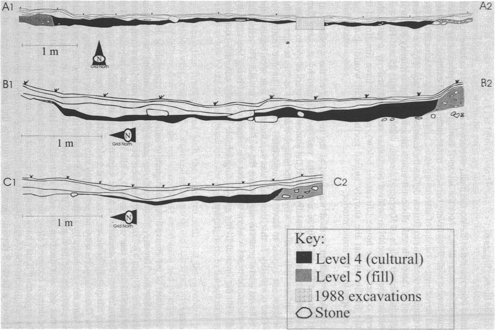
Figure 6
Proposed sequence of construction for the rear activity area. Stage 1 is prior to construction. Stage 2 represents the excavation of the house pit, displacement of the fill to the southern margin, and floor levelling. Stage 3 involves placement of the vertical cribbing and floor stones, and construction of the tiered walls. The final stage included positioning of the inferred tent poles and covering, and banking of fill to anchor the tent skirt.

Because House 6 is the only excavated Late Dorset structure in the western Central Arctic (single unexcavated Late Dorset domestic and longhouse structures have been reported from Melville Island [Henoch 1964; Taylor 1964b] and Prince Albert Sound [McGhee 1970] respectively), it is difficult to infer what materials were locally available and may have been used by the Late Dorset as roof supports. Certainly evidence from Late Dorset and Thule structures elsewhere in the Arctic suggests that the only suitable roofing materials were whalebone, wood, or antler (Meldgaard 1962; Wenzel 1979; Maxwell 1980; Arnold 1994; Gordon 1994; Savelle 1997). In eastern Amundsen and Coronation Gulfs, where several Thule structures have been excavated, whalebone was used minimally (Taylor 1972: 41; Morrison 1983, 1999; Le Mouël and Le Mouël 2002), not unsurprising given the region has been beyond the geographic range of bowhead whales for approximately 3000 years (Reeves et al. 1993; Dyke et al. 1996).
Instead, wood was much more frequently used (e.g., Taylor 1972: 9; Le Mouël and Le Mouël 2002: 181-183; also refer to Dyke et al. 1997) and appears to have been a highly valued material in the area, undoubtedly due to its rarity, as suggested by the removal of wooden roof supports from one Thule site for reuse elsewhere (Morrison 2000: 224). In fact, appropriate roofing materials were likely curated and used for extended periods (probably years), in much the same fashion as the ethnographically described Copper and Netsilik Inuit (Jenness 1922; Rasmussen 1931). There is no reason to suspect this pattern did not exist in the Late Dorset period, and that most or all houses, including House 6, would be built using wooden roof supports that were repeatedly recycled for new structures.
The rear activity area
An activity area of uncertain function was recognized in the northwestern corner of the house. This feature, which expanded outward from the main perimeter of the structure by approximately 25 cm, was defined by its relatively involved architectural elements including vertical stone and sod tiered sections of the north and west walls, a western margin that was cribbed with upright flagstones, and several flat paving stones (Figure 4). The associated cultural matrix was also thick and especially greasy when compared to that elsewhere in the structure (Figure 5B).
The feature appears to have been the most frequently and intensively used area of the house, as indicated by both the apparent care with which it was constructed, and the relative depth of the cultural deposit (Figure 5B). The occupation layer in this area was thicker and darker than anywhere else in the house, and can be characterized as very greasy and pungent (Helmer, in Taylor 1988, characterized the adjacent units E10 and E9 similarly in 1988). This suggests some sort of special activity, perhaps associated with cooking given the deposit's odour and the small quantity of charred bone and fat excavated. Although no soapstone was found in 2002, three pieces were excavated in 1988 from the adjacent units E10 and E9 (Figure 4), and lend some support to this interpretation.
The house floor
House 6 was not formally paved. Flat stones do occur variably, most frequently in association with the rear activity area (Figure 4), but are unpatterned and do not represent a clear feature. Rather, the floor was created by simply levelling out the underlying Level 6 beach surface, which may have been further tamped to create a solid footing (alternatively, this may have resulted from the day-to-day activities of the house inhabitants). The scarcity of rocks (particularly angular ones) inside the house contrasts with areas outside the depression, suggesting that the Late Dorset deliberately removed most stones from the house interior, generally only leaving the small flat rocks that would not cause undue discomfort. The use of a floor covering (probably skin as no vegetal material was found) in at least some portions of the structure is inferred by the thin (< 5 cm) and noticeably compacted cultural layer. The paucity of artefacts, flakes, and faunal material from the middle and front of the dwelling supports this interpretation.
The entranceway
A break in the eastern lake-ward wall, noted during the initial examination of the structure, was thought to be the probable location of the entrance. Excavation confirmed this assessment, further revealing that access to the structure's interior was gained via a passage-like construction extending from the main living area of the dwelling. This feature was created in large measure due to a decision by the builders not to dig through a natural hummock immediately in front of the house. Instead, the entrance was positioned asymmetrically on the eastern wall in order to skirt the hummock, with the result that this raised natural deposit was incorporated into the architecture of the structure as the northern perimeter of the entrance (Figure 4). The northern border of this passage-like entrance was further defined by the addition of several mid-sized rocks that were probably situated to further define the interior of this entrance. These rocks also aided in the interpretation of the stratigraphy of this area as the level 4 cultural deposit only occurred to the south of these rocks, within the entrance passage. In contrast, the southern border of the entrance area was less formally constructed, formed with the same mix of excavated substratum used to create the southern wall of the main living area. However, the contrast between the interior and exterior of the entrance was equally well marked stratigraphically (Figure 4C).
The passage-like entrance to House 6 is also notable for its apparent rudimentary cold-trap. Transit measurements reveal a 10 cm vertical difference existed between the floor of the main living area and the bottom of the adjacent entrance (Figure 5A). This differential, visible in the cross-section of the entrance way (Figure 4C), was probably sufficient to stop much of the cold exterior air from entering the interior of the dwelling.
Discussion of House 6 occupation
A relatively short-term occupation is supported by the low density of artefacts (the Late Dorset level produced less than 200 tools), generally thin cultural deposits, and the lack of an obvious external midden. Additionally, structural remains point to the selection of a low cost building strategy and strongly imply that occupation of the dwelling was not intended to be long term. This conclusion is based on the absence of a paved floor or other significant internal features (excluding the rear activity area), the use of immediately available building materials, and walls formed by fill displaced when the shallowly excavated floor was created. Finally, the entryway, which skirts rather than cuts through a sterile hummock, illustrates a desire by the builders to minimize the construction costs associated with the dwelling. This low-energy building strategy is consistent with an expectation by the builders that the structure would not be occupied for an extended period (see Kent 1991 for discussion of anticipated mobility).
Both the architecture and the fauna (the latter based on field inspection as the assemblage awaits full analysis) suggest that the structure was inhabited once during the late fall caribou migration period, with occupation probably also extending into some portion of the winter. Similar "between seasons" Late Dorset structures have been identified elsewhere in the Canadian Arctic, including southeastern Ellesmere Island (Helmer 1988), southern Baffin Island (Odess 1996: 175), and northern Labrador (Fitzhugh 1994: 258). Recognition of House 6 as a short-term late fall to early winter occupation poses additional questions about the seasonal mobility of Late Dorset groups in the Ekalluk River area. One obvious issue concerns where the inhabitants of House 6 went for the remainder of the cold season when they abandoned the structure.
One possibility is that they simply moved into the more deeply excavated semi-round structures present, but thus far only tested, at the Bell site. Another scenario involves the House 6 occupants relocating to snowhouses located on stable sea ice for the winter (Friesen, pers comm. 2002; see also Friesen 2002: 341), perhaps practising breathing hole hunting in much the same fashion as the historically recorded Copper Inuit (Jenness 1922). Such a scenario has previously been suggested for Dorset (Helmer 1981) and Pre-Dorset in the Jones Sound area of northern Devon Island (McCartney 1989). In either case, the less substantial architectural remains associated with House 6 may be seen as analogous with the historically known Inuit qarmat, often interpreted as a between seasons shelter (Mathiassen 1927: 133; cf. Park 1988). As such, House 6 demonstrates the potential of architectural data to further our understanding of Late Dorset mobility strategies on southern Victoria Island, as well as elsewhere in the Arctic.
Appendices
Acknowledgements
Data for this paper was acquired as part of the Iqaluktuuq Project (a co-operative University of Toronto-Kitikmeot Heritage Society project) and was funded by the Social Sciences and Humanities Research Council of Canada, the Polar Continental Shelf Project, and the Northern Scientific Training Program. Many thanks go to the 2002 field crew: Matthew Betts, Sarah Hazell, and Annie Veilleux (all from the University of Toronto), Neal Mala and Allison Evetalegak (both from Cambridge Bay), Miranda Atatahak (Kugluktuk), and Wally Porter (Gjoa Haven), as well as to Anton Wakulchyk of Canadian Helicopters for his good cheer and skill. My particular thanks go to T. Max Friesen, my doctoral supervisor, for introducing me to Iqaluktuuq, orchestrating the 2002 field season, and offering valuable suggestions on an earlier version of this paper. Thanks as well to Patricia Sutherland at the Canadian Museum of Civilization for helping me locate information relating to the 1988 research. Sincere gratitude goes to Matthew Betts for reading previous drafts of this paper and assistance with Figure 1. As well, two anonymous reviewers provided useful comments. All errors are mine alone.
Notes
-
[1]
Bearings refer to the excavation grid, which was oriented according to the house and not to cardinal points.
-
[2]
Helmer's fieldnotes (in Taylor 1988) confirmed that the disturbed areas correspond to the 1988 excavation grid of a structure identified as House 2. However, the House 2 of the 1988 season does not match Taylor's 1963 House 2 (Taylor 1964a, 1972), the location of which could not be established from his site map. The only other reference to a House 2 occurs in the Bell site artefact catalogue (on file at the CMC), which suggests the original House 2 may have been Thule. For the sake of clarity, designation of the 2002 structure as House 6 was retained.
References
- ARNOLD, Charles D., 1994 The Importance of Wood in the Early Thule Culture of the Western Canadian Arctic, in D. Morrison and J.-L. Pilon (eds), Threads of Arctic Prehistory: Papers in Honour of William E. Taylor, Jr., Hull, Canadian Museum of Civilization, Archaeological Survey of Canada, Mercury Series, 149: 269-280.
- CANADIAN ARCHAEOLOGICAL RADIOCARBON DATABASE (CARD), n.d. Compiled by Richard Morlan.
- DYKE, Arthur S., James HOOPER and James M. SAVELLE, 1996 A history of sea ice in the Canadian Arctic Archipelago based on postglacial remains of the bowhead whale (Balaena mysticetus), Arctic, 49(3): 235-255.
- DYKE, Arthur S., John ENGLAND, Erk REIMNITZ and Hélène JETTÉ, 1997 Changes in driftwood delivery to the Canadian Arctic Archipelago, Arctic, 50(1): 1-16.
- FITZHUGH, William W., 1994 Staffe Island and the Northern Labrador Dorset-Thule succession, in D. Morrison and J.-L. Pilon (eds), Threads of Arctic Prehistory: Papers in Honour of William E. Taylor, Jr., Hull, Canadian Museum of Civilization, Hull, Archaeological Survey of Canada, Mercury Series, 149: 239-268.
- FRIESEN, T. Max, 2000 The Iqaluktuuq Project: Archaeology on the Ekalluk River near Cambridge Bay, Nunavut, Nunavut Archaeology Permit 00-009, unpublished manuscript on file, Gatineau, Canadian Museum of Civilization.
- FRIESEN, T. Max, 2002 Analogues at Iqaluktuuq: the social context of archaeological inference in Nunavut, Arctic Canada, World Archaeology, 34(2): 330-345.
- GORDON, Bryan C., 1994 Nadlok and the origin of the Copper Inuit, in D. Morrison and J.-L. Pilon (eds), Threads of Arctic Prehistory: Papers in Honour of William E. Taylor, Jr., Hull, Canadian Museum of Civilization, Archaeological Survey of Canada, Mercury Series, 149: 325-340.
- HELMER, James W., 1981 Climate Change and Dorset Culture Change in the Crozier Strait Region, NWT: A Test of the Hypothesis, Ph.D. dissertation, Calgary, University of Calgary, Department of Archaeology.
- HELMER, James W., 1988 The 1987 Jones Sound Archaeology Project, unpublished manuscript on file, Calgary, University of Calgary, Department of Archaeology.
- HENOCH, W. E. S., 1964 Preliminary geomorphological study of a newly discovered Dorset culture site on Melville Island, Arctic, 17(2): 119-125.
- JENNESS, Diamond, 1922 The Life of the Copper Eskimos, Ottawa, F.C. Acland, Report of the Canadian Arctic Expedition 1913-18, 12(1).
- KENT, Susan, 1991 The relationship between mobility strategies and site structure, in E.M. Kroll and T.D. Price (eds), The Interpretation of Archaeological Spatial Patterning, New York, Plenum Press: 33-59.
- Le MOUËL, Jean-François and Maryke Le MOUËL, 2002 Aspects of the early Thule culture as seen in the architecture of a site on Victoria Island, Amundsen Gulf area, Arctic, 55(2): 167-189.
- MATHIASSEN, Therkel, 1927 Archaeology of the Central Eskimos: Descriptive Part, Copenhagen, Gyldendalske Boghandel, Nordisk Forlåg, Report of the Fifth Thule Expedition 1921-1924, 4(1).
- MAXWELL, Moreau S., 1980 Dorset site variation on the southeastern coast of Baffin Island, Arctic, 33(3): 505-516.
- McCARTNEY, Peter H., 1989 Palaeoeskimo Subsistence and Settlement in the High Arctic, Ph.D. dissertation, Calgary, University of Calgary, Department of Archaeology.
- McGHEE, Robert, 1970 An archaeological survey of western Victoria Island, N.W.T., Canada, National Museum of Man Bulletin, 232: 157-191.
- MELDGAARD, Jørgen, 1962 On the formative period of Dorset culture, in J.M. Campbell (ed.), Prehistoric Cultural Relations Between the Arctic and Temperate Zones of North America, Montreal, Arctic Institute of North America, Technical Paper, 11: 92-95.
- MORRISON, David, 1983 Thule sea mammal hunting in the Western Central Arctic, Arctic Anthropology, 20(2): 61-78.
- MORRISON, David, 1999 The earliest Thule migration, Canadian Journal of Archaeology, 22(2): 139-156.
- MORRISON, David, 2000 The Arrival of the Inuit: Amundsen Gulf and the Thule Migration, in M. Appelt, J. Berglund and H.C. Gulløv (eds), Identities and Cultural Contacts in the Arctic, Copenhagen, Danish National Museum and Danish Polar Center, Danish Polar Center Publication, 8: 221-228.
- ODESS, Daniel, 1996 Interaction, Adaptation, and Culture Change: Lithic Exchange in Frobisher Bay Dorset Society, Baffin Island, Arctic Canada, Unpublished Ph.D. dissertation, Department of Anthropology, Brown University, Providence.
- PARK, Robert W., 1988 "Winter houses" and qarmat in Thule and historic Inuit settlement patterns: some implications for Thule studies, Canadian Journal of Archaeology, 12: 163-175.
- RASMUSSEN, Knud, 1931 The Netsilik Eskimos: Social life and spiritual culture, Copenhagen, Gyldendalske Boghandel, Report of the Fifth Thule Expedition, 1921-24, 8(1-2).
- REEVES, Randall, Edward MITCHELL, Arthur MANSFIELD and Michele McLAUGHLIN, 1983 Distribution and migration of the bowhead whale, Balaena mysticetus, in the eastern North American Arctic, Arctic, 36(1): 5-64.
- SAVELLE, James M., 1997 The role of architectural utility in the formation of zooarchaeological whale bone assemblages, Journal of Archaeological Science, 24: 869-885.
- SCHIFFER, Michael B., 1987 Formation Processes of the Archaeological Record, Salt Lake City, University of Utah Press.
- TAYLOR, William E., 1964a Interim report of an archaeological survey in the Central Arctic, 1963, Anthropological Papers of the University of Alaska, 12(1): 46-55.
- TAYLOR, William E., 1964b Archaeology of the McCormick Inlet site, Melville Island, N.W.T., Arctic, 17(2): 125-129.
- TAYLOR, William E., 1967 Summary of archaeological field work on Banks and Victoria islands, Arctic Canada, 1965, Arctic Anthropology, 4(1): 221-243.
- TAYLOR, William E., 1972 An Archaeological Survey Between Cape Parry and Cambridge Bay, N.W.T., Canada in 1963, Ottawa, National Museum of Man, Archaeological Survey of Canada, Mercury Series, 1.
- TAYLOR, William E., 1988 Untitled: Fieldnotes, 1988, unpublished manuscript no. 3105, vol. 3, on file, Gatineau, Canadian Museum of Civilization.
- WENZEL, George, 1979 Analysis of a Dorset-Thule structure from northwestern Hudson Bay, in A.P. McCartney (ed.), Thule Eskimo Prehistory: An Anthropological Retrospective, Ottawa, National Museum of Man, Archaeological Survey of Canada, Mercury Series, 88: 122-133.
List of figures
Figure 1
Map showing the location of the Ekalluk River and the Bell site. The river, which flows westward into Wellington Bay, functions as a natural funnel for migrating caribou.
Figure 2
Map of the Bell site, showing the location of House 6 in relation to the other features (map: courtesy of T. M. Friesen)
Figure 3
Placing the grid on House 6 prior to excavation. Note the shallow and ephemeral nature of the structure. Right to left, Annie Veilleux stands on the embankment immediately north of the house, Sarah Hazell sits near the rear wall, Matthew Betts stands on the natural hummock in front of the house depression, while Karen Ryan is in the entrance (photo: courtesy of T. M. Friesen).
Figure 4
Plan of House 6. The passage-like entrance is on the right of the plan, the rear activity area is on the upper left, while the shaded areas relate to the 1988 test excavations. The upper case letters refer to the location of the stratigraphic cross-sections (Figure 5).
Figure 5
Stratigraphic cross-sections of House 6 (note differences in scale). A) shows the west-east long axis, B) depicts the north-south rear short axis, while C) represents the north-south entrance.
Figure 6
Proposed sequence of construction for the rear activity area. Stage 1 is prior to construction. Stage 2 represents the excavation of the house pit, displacement of the fill to the southern margin, and floor levelling. Stage 3 involves placement of the vertical cribbing and floor stones, and construction of the tiered walls. The final stage included positioning of the inferred tent poles and covering, and banking of fill to anchor the tent skirt.