
Abstracts
Abstract
Four transitional period sites on Somerset Island compare closely with High Arctic sites attributed to Independence II. The four sites are situated at elevations between Pre-Dorset and Early Dorset occupations in the same area. The sites are described, with an emphasis on architectural characteristics. Vertical slab midpassage structures are present at all sites along with artifact assemblages containing shallowly side-notched bifaces, "cloven hoof" lance heads, a closed socket harpoon head, burin-like tools, narrow microblades, and needles with gouged eyes. Some sites also have exterior hearths and possible caches. Radiocarbon dates place the occupations within the transitional period (i.e. 800-500 B.C.). As during Independence II, the sites are of various size (three small ones and a large one), and are in association with polynyas.
Résumé
Quatre sites de la période transitionnelle sur l'île Somerset se comparent bien à des sites de l'Indépendancien II du Haut Arctique. Les quatre sites se situent dans la même région à des élévations entre des occupations du Prédorsétien et du Dorsétien ancien. Ces sites sont ici décrits en mettant l'accent sur leurs caractéristiques architecturales. Sur tous ces sites, on remarque des aménagements axiaux à dalles verticales ainsi que des assemblages contenant des bifaces à encoches latérales peu profondes, des pré-hampes de lances à “sabot fourchu”, des têtes de harpon à logette fermée, des simili-burins, des microlames très minces et des aiguilles à chas incisés. Certains de ces sites présentent aussi des foyers extérieurs et de possibles caches. Les datations au radiocarbone placent ces occupations dans la période de Transition (i.e. 800-500 av. J.-C.). Tout comme durant l'Indépendancien II, les sites sont de dimensions variées (trois petits et un grand) et associés à des polynies.
Article body
Introduction
In the decades following Diamond Jenness' (1925) recognition of the Dorset culture as an earlier stage distinct from Thule culture in the Eastern Arctic, archaeologists focused attention on the question of Dorset origins (e.g., Collins 1940, 1950, 1955; Mathiassen 1927, 1930; Meldgaard 1960a, 1962). After Taylor (1968: viii) demonstrated convincingly a basic cultural continuity from Pre-Dorset to Dorset culture, interest turned more specifically to the period of transition, thought to have occurred between about 800 and 500 B.C. Sites from this period have been variously referred to as "Independence II," "Dorset I," and "Early Dorset" in Greenland (Andreasen 1996, 1997, 1998, 2000; Jensen 1996; Knuth 1952, 1954, 1958, 1966/67, 1967, 1968; Møbjerg 1986), "Independence II," "Early Dorset," or "transitional" in High Arctic Canada (Helmer 1980, 1991; McGhee 1981, 1996; Schledermann 1990, 1996; Sutherland 1996), "Dorset I," "Early Dorset," or "transitional" in the Eastern Arctic (Maxwell 1985; Meldgaard 1955, 1960b, 1962; Nagy 1994, 2000; Taylor 1968), and "Groswater" or "Early Dorset" in Labrador, Newfoundland, and parts of Quebec (Auger 1986; Cox 1978; Fitzhugh 1972, 1976, 1980; Harp 1997; Pintal 1994; Plumet 1994; Renouf 1993, 1994, 1999, 2002; Tuck 1975, 1976; Tuck and Fitzhugh 1986). While not synonymous, these terms have been applied to what Nagy (2000) suggests, following Helmer (1994), can usefully be considered a transitional cultural horizon bridging the short temporal gap between Pre-Dorset and Dorset cultural traditions.
The purpose of this paper is to present data from four transitional period sites on the southeast coast of Somerset Island, situated west of Baffin Island and just north of Boothia Peninsula. The fieldwork on which this paper is based took place in 1983 to 1985 on the southeast coast of Somerset Island, between Creswell Bay and Bellot Strait (Figure 1). Considerable research had been conducted in the area, much of which focused on large Thule sites (e.g., Clarke 1979; McCartney 1979; Taylor and McGhee 1979; VanStone 1962; Yorga 1979). In 1977, Schledermann (1978) recorded 45 sites in the area, as many as 21 of them thought to contain Palaeo-Eskimo components. Additional Palaeo-Eskimo research was undertaken to the west at Aston Bay and at Stanwell Fletcher Lake (Bielawski 1980, 1982).
Our research focused on Palaeo-Eskimo sites, primarily Late Dorset, but included other sites, especially while surveying. We recorded 54 new Palaeo-Eskimo sites (containing at least 57 components), the majority situated along the relatively complex and protected coasts near the east end of Bellot Strait and on the eastern portions of inner Creswell Bay. Four of the components can be placed in the transitional period between Early and Late Palaeo-Eskimo, based on elevation, architecture, artifacts, and radiocarbon dates (Figure 1).
PeJr-7
PeJr-7 is located on the south coast of inner Creswell Bay, about 9 m asl, just west of a long point constricting the bay into "inner" and "outer" portions producing a small polynya due to strong tidal currents. Feature 1 is a slab-lined midpassage structure while Features 2 and 3 are possibly similar structures where the vertical slabs are not visible on the surface. A fourth structure, somewhat set apart from the others and with no apparent midden, uses long narrow rocks resting on the surface, rather than embedded slabs, to produce what may be a toy midpassage structure.
Figure 1
Map showing the locations of four Somerset Island transitional period sites (inset map) and similar sites in other areas: (a) PeJr-7; (b) PeJr-24; (c) PeJs-15; and (d) PaJs-39. (see Andreasen 1996, 1997, 1998, 2000; Knuth 1967, 1968, 1981, 1983; McGhee 1981)

PeJr-24
This site is located on the north side of inner Creswell Bay, straddling an outwash channel over 100 m wide that may have removed portions of the site. Eight stone features at about 9 m asl include at least two, and possibly four, vertical slab midpassage features, several scatters of flat slabs, and one possible exterior hearth constructed of vertical slabs.
PeJs-15
Also about 9 m asl, a small group of features is situated on the west side of a ridge that was once a small point extending from the north shore of inner Cresswell Bay. The site consists of two slab-lined midpassage features, and two exterior hearths.
The Phalarope site (PaJs-39)
The Phalarope site is located at the east end of Bellot Strait within sight of Boothia Peninsula. It is a large site containing at least 68 archaeological features — more than three times the combined total from the other three sites — and covering about 1.8 hectares of coarse dolomite gravel and rock. Archaeological features are found up to 16 m asl while the lowermost features are about 9.5 m asl (Figure 2). Fifty metres north of the site is a sizable fresh water pond that would probably have existed at the time of occupation.
Archaeological features identified at the Phalarope site include 29 dwelling structures, 19 exterior (box) hearths, 13 possible caches, and seven features of unknown function. There is considerable variability in the form of dwelling features, the range of which we tried to capture with a sample of seven excavated features. Before describing the excavated features, however, one structure stood out as a near-classic example of a slab-lined midpassage, so much so that we refrained from disturbing it through excavation.
Feature 29
Feature 29 is located at the western edge of the main cluster of dwelling features at 12.5 m asl. This well-preserved structure is outlined by an uneven clustered distribution of flat slabs encircling a roughly oval 2.9 m by 3.4 m area that has been cleared of coarse gravel (Figure 3). The largely intact midpassage is 210 cm long, between 50 and 60 cm wide, and is oriented approximately north-south, perpendicular to the long axis of the dwelling and to the coastline. The midpassage appears to have been set 60 to 70 cm back from the entrance, against the back wall. The long sides of the midpassage are defined by three or four vertical, or near vertical, slabs. Individual cross-slabs are present at the north end and about 125 cm south of this, or two thirds of the way along the midpassage. Black lichen growth in the central part of the passage suggests a concentration of organic nutrients and probably indicates the location of a hearth. Feature 29 was not excavated and no associated artifacts were recovered.
Feature 14
Feature 14 is situated about 11.5 m asl in the eastern portion of the site. In contrast to Feature 29, it has no clear evidence of a midpassage. It is defined by an irregular but approximately oval area cleared of larger pieces of gravel, to make a comfortable living floor about 2.1 m by 2.7 m in size (Figure 4). A few rocks are present around the margins, especially on the east side, but it could not be characterized as a well-defined tent ring.
The only piece of terrestrial mammal bone from Feature 14 — a muskox metatarsus — was submitted for AMS dating (see Figure 4 for location). The specimen was found in a near-surficial context, lightly covered with vegetation. It was selected for dating due to its good state of preservation. A corrected date of 890 ± 25 B.P. (KIA-18938; muskox bone collagen; ∂13C = -21.47 ± 0.100/00) yields a calibrated age between cal A.D. 1040 and 1215, at 2 sigma. If the feature is from the transitional period, this date is much too recent and must relate to a later, unknown, intrusive event.
Feature 15
Feature 15 is located about 25 m south of Feature 14 and about 1 m lower at 10.5 m asl. The living floor is defined by a 2.9 m by 3.5 m oval area cleared of coarse gravel (Figure 5). There are a few rocks along the perimeter and some inside forming no distinct pattern. Both vegetation and cultural material were concentrated in the axial area, particularly in the very centre of the dwelling where there was also evidence of burning.
A fragment of caribou bone from Feature 15 was submitted for AMS dating. A corrected date of 2610 ± 25 B.P. (KIA-18940; caribou bone collagen; ∂13C = -19.20 ± 0.100/00) yields a calibrated age of 825-780 cal B.P., at 2 sigma. This is consistent with early transitional period dates from elsewhere (Andreasen 1998; Maxwell 1985; McGhee 1996; Nagy 2000).
Figure 2
Map of Phalarope site (PaJs-39). Numbered features are discussed in the text

Figure 3
Phalarope site, Feature 29

Figure 4
Plan map of Phalarope site, Feature 14

Figure 5
Plan map of Phalarope site Feature 15. See Figure 4 for legend

Feature 21
Feature 21 lies about 25 m north of Feature 14, at 13 m asl. As with Features 14 and 15, there is no slab-lined midpassage (Figure 6). The area cleared of coarse gravel, measuring 2.5 m by 4.0 m, is approximately oval but somewhat wider, front to back, on the west side. Peripheral rocks are discontinuous, being more abundant in the north (rear) half of the dwelling. A small central area of burned fat and fire-reddened gravel coincides with a concentration of artifacts and faunal remains, and likely represents a central hearth. Artifacts, debitage, and faunal remains are all concentrated along a central axial area. West of this are three angled slabs set in a triangular formation that appear to be a lamp or pot support.
Feature 28
Located about 35 m west of the previous three structures, at about 12.5 m asl, Feature 28 is not well defined by rocks, but its presence is evident from a central vegetation patch. Like previous features, the interior area has been cleared of coarse gravel, though less thoroughly. This has produced a slight depression, especially along the back wall (Figure 7). As seen previously, the cleared area is slightly wider on the west side. The best estimate of size is 2.2 m by 3.6 m.
There is no slab midpassage feature but a small depression situated near the south end of the central axis, and a nearby, partially fire-reddened, slab may be from a dismantled slab feature. Certainly, the distribution of artifacts, debitage, and faunal remains reflect some kind of axial arrangement of space, with most items being found within the small depression or immediately to the north. Two angled slabs, and a third horizontal slab, clustered on the west side of the feature, may be analogous to the lamp or pot stand noted in Feature 21.
Feature 39
Sitting 11.5 m asl at the approximate centre of the site, Feature 39 contains a slab-lined midpassage that is well defined despite leaning slabs (Figure 8). The feature is situated over an oval patch of fine gravel, the edge of which is clearest on the north (rear) side where coarse gravel creates a berm with a line of small rocks on top, clearly defining the back wall (Figure 9). A curving line of rocks along the east side, in addition to those on the north side, provides a clearer outline than is seen in the majority of dwelling features at the site, but it is notable that many of these "wall" rocks seem rather small, if their primary function was to anchor a tent. Assuming the dwelling was symmetrical on either side of the midpassage, the floor measures approximately 2.8 m by 3.5 m and is oval.
Most rocks in the midpassage have fallen over but the general form is quite clear. It is 2 m long and 60 cm wide at the north (back) end. Width at the south end is less certain but appears to have been about 50 cm. This slight narrowing towards the front has also been observed by Knuth (1966/67) of "Indpendence II" structures in Greenland. The long sides of the midpassage are composed of three to four slab sections, each about 40 to 60 cm long. It appears that both ends of the passage were originally blocked by cross-slabs and there was at least one additional cross-slab about 65 cm from the south end. This is approximately the same position as the single internal cross member in the Feature 29 midpassage. The gravel inside the midpassage is generally coarser than that to either side and many pieces are fire-reddened, especially in the central part, where a hearth may have been situated. Like the midpassage in Feature 29, this one is set against the back wall of the dwelling, leaving about 0.75 m of open space between it and the front wall or entrance.
Figure 6
Plan map of Phalarope site Feature 21. See Figure 4 for legend.

Figure 7
Plan map of Phalarope site Feature 28. See Figure 4 for legend.
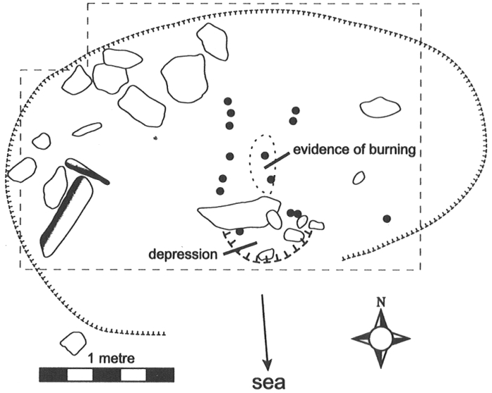
Figure 8
View of Phalarope site Feature 39, looking south

Figure 9
Plan map of Phalarope site Feature 39. See Figure 4 for legend.

Feature 45
Feature 45 is located about 25 m northwest of Feature 15 at a similar elevation of 10.5 m asl. A group of angled slabs is situated roughly in the centre, probably the collapsed remnants of a midpassage. However, any details of such an axial construction have been lost due to the slumping of once vertical slabs and possibly the removal of others. Two rocks on the west edge of the excavated area could be part of a lamp or pot stand, similar to those in Features 21 and 28. Using what limited evidence there is, the dimensions of Feature 45 are estimated to be 2.5 to 3 m by 3.5 to 4 m.
Feature 54
Set somewhat apart from, and overlooking, the rest of the site, three dwelling features and a cache are distributed along the west edge of a plateau-like ridge. From here, the shoreline to the west, and the Bellot Strait polynya beyond, are also visible. At about 16 m asl, these are the highest recorded features at the Phalarope site. Feature 54 was excavated to confirm that these upper features are generally related to those at lower elevations.
On the surface, Feature 54 is comparatively well outlined by rocks, at least on three sides, and a partially sunken slab midpassage is evident (Figure 10). Vegetation is patchy but heaviest near the midpassage. Much of the dwelling's interior appears to have been cleared of coarse gravel and rocks though delimiting the cleared area is not easy. A thin line of wall rocks is apparent along the front of the dwelling and, a little less definitively, along the southwest side and back walls, while the northeast side is poorly defined (Figure 11). Estimated dwelling size is 3 m by 4 m and the shape seems to be oval to subrectangular, and possibly slightly bilobate. A group of three angled slabs in the southwest half of the dwelling, arranged to form a three-sided depression, may be a lamp or pot stand similar to those in Features 21, 28 and 45.
The midpassage is constructed of at least five, and probably six, pairs of small parallel slabs, each 15 to 35 cm long with 5 to 35 cm gaps between adjacent slabs. Together, these form two almost parallel rows about 2 m in length set 40 to 45 cm apart, with the back portion of the midpassage appearing to be slightly wider than the front. Several horizontal slabs lying near the centre of the midpassage may once have been vertical, forming the sixth pair of side-slabs and probably at least one transverse cross-slab. As it is, there are no in situ cross-slabs either at the ends or along the inside of the midpassage. Prior to excavation, the surface of the central part of the midpassage was slightly depressed and excavation showed that it contained numerous small rocks. The central portion of the midpassage contained darker matrix and a little burned fat under a horizontal slab, suggesting it was a hearth area. Within the dwelling, the midpassage is set against the back wall, leaving almost 1 m of open space between the front of the midpassage and the presumed front wall and entrance of the dwelling.
Figure 10
View of Phalarope site Feature 54, looking west
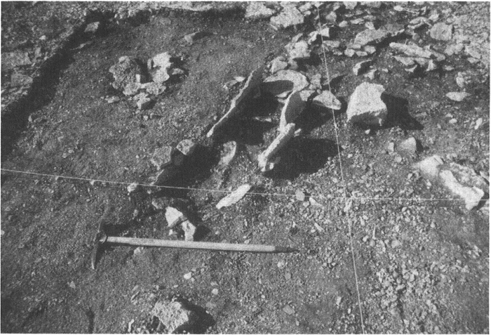
Figure 11
Plan map of Phalarope site Feature 54. See Figure 4 for legend.

A fragment of muskox bone from beneath a central slab in Feature 54 was submitted for AMS dating. A corrected date of 2450 ± 20 B.P. (KIA-18939; muskox bone collagen; ∂13C = -18.67 ± 0.110/00) yields a range of calibrated ages between 760 and 408 cal B.C. at 2 sigma. This broad range is due to the presence of a plateau in the calibration curve between 760 and 400 cal B.C. Unfortunately, it is not possible to obtain finely resolved calibrated dates in this range (Stuiver et al. 1998). Nevertheless, this date is consistent with a transitional period association and supports the view that these upper features, at 16 m asl, are related to the rest of the site.
Exterior hearths
Nineteen features are identified as exterior hearths (although some may be caches). Their distribution places them largely on the perimeter of the main cluster of dwelling structures — mostly to the south and west but not on the high area occupied by Feature 54 (Figure 2). Those along the south margins of the site are almost 1 m lower in elevation than the lowest dwellings and may have been located very close to the water when in use. Some are situated in rough or more steeply sloping areas of the site, unsuitable for dwellings.
These features are usually composed of vertical rock slabs forming a square or rectangle approximately 50 to 75 cm on a side. In some cases the bottom is lined with a horizontal slab or one side is open. Although no artifacts or burned material were found in association, their use as hearths is indicated by the fire-reddening seen on some slabs. No exterior hearths were excavated.
Caches
Thirteen features are tentatively identified as caches (Figure 2). As with exterior hearths, a few are situated amongst the main group of dwelling features, but most are located in peripheral areas of the site. The majority are small clusters of cobbles and boulders averaging about 1 m in size — suitable only for caching a small amount of material. Two caches are larger and more distinctive. Feature 58 is located on a steep boulder and slab beach well to the west of the main cluster of dwellings. The 3.5 to 4 m wide feature is constructed of large slabs arranged in a circular pattern around a small central area, like petals of a flower. Feature 66 consists of 10 boulders placed to form a circle about 2.5 m in diameter, leaving a 1.5 m open area in the centre.
Artifacts
Just over 200 formal artifacts were recovered from the Phalarope site about two thirds made of stone — primarily chert — the rest made of bone, antler or ivory, which was well preserved when sheltered by rocks or gravel and moderately preserved when protected by vegetation (see Table 1 and Figure 12). The assembage is quite typical of transitional period sites and compares particularly closely with sites from Port Refuge, Devon Island, that McGhee (1981) had attributed to Independence II.
Faunal remains
A sample of 2,511 faunal specimens was recovered, 1,163 (46%) of which could be identified to species or genus (or to order, in the case of fish). Figure 13 illustrates relative frequencies of identified specimens (NISP) by major faunal group for each excavated dwelling, including their respective middens.
Sea mammals dominate, constituting 83% of the combined sample. Almost all of this is small seal, very likely ringed seal. Bearded seal and walrus each make up less than 1% of the identified sea mammal bones. Ungulates account for 2.7% of the identified assemblage, with muskox about three times as common as caribou. The only other mammal is Arctic fox, represented by only five specimens in Feature 15 and one in Feature 54, amounting to 0.5% of the total. Birds account for 10.7% of the identified fauna, 7.2% being waterfowl and the remainder shorebirds and gulls. The waterfowl include king eider, oldsquaw, and goose, probably snow goose. Only two of the 37 fish bones could be identified as Salmonidae, but they are likely all char. The unidentified fish were included in the NISP figures to ensure their presence would be evident in Figure 13.
The presence of fish and waterfowl suggests warm season occupation, recognizing that resources could be carried over from a warm to a cold season by means of storage. All of the structures contain some waterfowl but there is variability in species and frequency that could reflect seasonal differences between structures. It may be significant that goose and oldsquaw are restricted to Features 39, 45, and 54, the three structures with the clearest indication of a slab-lined midpassage. Fish, too, are found only in Features 39 and 45. On the other hand, the remaining four structures contain eider, which is absent from Features 39, 45, and 54. Precisely what this means in terms of seasonality is not clear, as all these waterfowl are migratory. Eider do have distinctive migratory patterns, which generally involves them leaving the area earlier than geese and oldsquaw (Alliston et al. 1976). Overall, the faunal data suggests a seasonal basis for the presence or absence of midpassages and implies the possibility that midpassages are warm season related. The numerous exterior hearths, if that is what they are, would also be consistent with a warm season of occupation.
Figure 12
Transitional period artifacts from the Phalarope site (a-g; i-v) and the PeJr-7 site (h): (a) harpoon head; (b) harpoon head preform; (c-d) harpoon foreshafts; (e) lance head; (f) lance foreshaft; (g-h) notched bifaces; (i-j) burin-like tools; (k-m) endscrapers; (n-p) microblades; (q-r) microblade cores; (s) flaker; (t-u) needles; (v) abrader

Table 1
Phalarope site (PaJs-39) artifacts, listed by dwelling structure

Discussion
There are four lines of evidence indicating these sites fall into the transition period: elevation, architecture, artifacts and radiocarbon dates. Each will be discussed below.
Elevations
Figure 14 shows elevations of the lowermost features at 54 Palaeo-Eskimo sites recorded during our survey work on southeast Somerset Island. Our brief reconnaissance suggests that sites more than 11 m asl are Pre-Dorset (and possibly some Independence I) while those below 9 m are Dorset. Sites between 9 and 10 m are either transitional or Early Dorset. These elevations, and the inferred ages, are consistent with isostatic rebound curves for the region (Dyke 1983). There are few sites between 11 and 13 m, possibly reflecting a Pre-Dorset population decline just prior to the transitional period, as suggested by McGhee (1981). On the other hand, sites I regard as Early Dorset begin at elevations similar to those for the transitional sites discussed in this paper, implying very little time between the two or possibly local continuity. Admittedly, the distinction I am drawing between transitional and Early Dorset sites in this sample of sites is arbitrary and based on material differences — the absence of slab midpassages and the presence of triangular endblades and sliced harpoon heads being most important in distinguishing Early Dorset. Obviously, caution must also be exercised with elevation data since some of the sites are only tentatively classified and because people may not always have camped close to the shore. This is apparent at the Phalarope site where beaches as high as 16 m were used while water levels were probably about 8 or 9 m above current sea level. Here, however, I believe the reasons for placing structures at higher elevations involved relationships with previous or contemporary dwellings on the lower beaches. It would also be imprudent to assume that all beaches over the wide area of our survey received similar scrutiny, so sampling error may be a factor.
Architecture
Perhaps the most notable characteristic of the four sites described in this paper is the presence of vertical slab midpassage features. Typically measuring about 2 m by 40 to 60 cm, midpassages contain cross-slabs and a central hearth area. Where upright slabs are absent, a depressed strip of coarse gravel sometimes defines the axial area. In other cases, no axial feature is evident. However, the distribution of artifacts and other material remains consistently suggests an axial arrangement of space, even in the absence of an axial feature. This adherence to axial principles was one of long standing among Palaeo-Eskimos, possibly due to symbolic associations and deep historical roots (Odgaard 1998).
A few stones vaguely mark the perimeter of most dwelling structures. Additionally, coarse gravel has been removed from interior floor areas, sometimes to the extent that a slight gravel berm is present along the back wall. Where dwelling outlines are evident, they are oval to slightly subrectangular, sometimes with a bilobate appearance at the front. Overall dwelling dimensions average approximately 2.75 m by 3.5 m. With a 2 m-long midpassage, this leaves roughly 0.75 m of open area between the front end of the midpassage and the presumed front wall and entrance of the structure. Several dwellings at the Phalarope site have a small cluster of three or four rocks situated on the right side of the dwelling (from the perspective of an occupant) that may have served to support a lamp or stone vessel.
Figure 13
Phalarope site faunal remains compared by feature

Figure 14
Distribution graph of minimum elevations of 54 Palaeo-Eskimo sites from Somerset Island

These dwellings and, in particular, the midpassages are very similar to ones associated with High Arctic transitional sites, sometimes referred to as Independence II (Andreasen 1996, 1997, 1998, 2000; Knuth 1952, 1954, 1958, 1966/67, 1967, 1968; McGhee 1981; Schledermann 1990; Sutherland 1996). Some similarities can also be seen far to the south in the Belcher Islands where Harp (1997) found slab-lined axial features with Early Dorset artifacts at the Tuurngasiti 2 site.
In addition to the dwelling structures, there are exterior box features constructed of vertical slabs and a variety of small cache or cache-like boulder features. The caches could be especially important if they reflect a greater emphasis on storage, compared with earlier times. Overall, these sites are very similar to other reported Independence II sites. Also similar is the presence of both small sites and quite large ones that seem to have been used repeatedly, and the tendency for sites to be associated with polynyas (Andreasen 1998).
Artifacts
The artifact assemblages are as noteworthy for what is absent as for what is present. Notched bifaces, including those that might be endblades, have broad, shallow side-notches. These are widespread in transitional and Dorset assemblages. Absent are multiple side-notches and triangular endblades, typically associated with Dorset. Furthermore, tip fluting, another Dorset trait, is absent, as is ground slate. Microblades are abundant and narrow, which is characteristic of both transitional and Early Dorset assemblages. True burins, typical of Pre-Dorset, are absent while two types of ground burin-like tools are present. Adze blades and soapstone vessels are present, which is consistent with Early Dorset and with some transitional sites. "Cloven-hoof" lance heads with sideblade sockets, bone flakers, and needles with rectangular cross-sections and narrow gouged eyes are all represented in both transitional and Early Dorset assemblages.
The single complete harpoon head, with a sunken endblade bed and lashing groove at the distal end and a perforated closed socket at the proximal end, is a blend of two forms from Meldgaard's Type Line D found on the 24 m beach at the Jens Monk site, Igloolik. Similar forms of perforated closed socket harpoon heads, with both slotted and self-bladed distal ends, occur throughout Igloolik from the 24 to the 22 m levels (Jørgen Meldgaard, pers. comm. 2002). In addition to the Jens Monk site, harpoon heads with sunken beds and lashing grooves are reported from Independence II (Knuth 1968) and late Pre-Dorset (Andreasen 2000) in northern Greenland. But like the Jens Monk specimen, these have open or flanged sockets, as do most Independence II harpoon heads (Knuth 1967). The exception is Independence II material from Port Refuge, Devon Island, where closed, perforated, sockets were used, but with the self-bladed distal ends more typical of Independence II (McGhee 1981). In short, the Phalarope harpoon head is unique in the literature, but its attributes are known from the 24 to 22 m beaches at Igloolik and from Independence II. According to Maxwell (1985:184), "the transition from Pre-Dorset to Dorset takes place at Igloolik between the 24- and 22-m terraces." The second harpoon specimen, a preform, appears intended to be self-bladed, which is more typical of Independence II.
Radiocarbon dates
The two acceptable radiocarbon dates of 2450 ± 20 B.P. and 2610 ± 25 B.P. place the Phalarope site within the time range associated with Independence II (Andreasen 1997). The earlier date, from Feature 15, provides a sharply defined age of 825-780 cal B.P. at the 2 sigma (95.4%) level of confidence. This quite definitively places Feature 15 at the early end of the transitional period. The date from Feature 54 is less definitive, due to the nature of the calibration curve, but is likely somewhat younger than the Feature 15 date. This is consistent with the view that substantially intact and/or outlying features at the Phalarope site, like Feature 54, are likely to be later and have escaped scavenging of slabs.
The date of 890 ± 25 B.P. from Feature 14 would suggest either a Late Dorset or Early Thule association. Nothing else found at the site would substantiate such an association and I reject this date as unrelated to the main occupation.
Conclusions
Four Palaeo-Eskimo sites from Somerset Island have been briefly described, with an emphasis on architectural characteristics. The interpretation of these sites as transitional relies both on temporal and material criteria. Two radiocarbon dates indicate the occupations probably date to the 800 to 500 B.P. window when the Pre-Dorset to Dorset transition is thought to have occurred (Nagy 2000). The midpassage features and artifact assemblages find their strongest parallels with High Arctic sites that have usually been classified as Independence II, which also dates to this 800 to 500 B.P. period. The Somerset Island sites expand the known extent of Independence II about 500 km south of the former limits. Indeed, the Phalarope site is almost as close to Igloolik as it is to Port Refuge (Figure 1).
Within the local context, there appears to be no direct link with Pre-Dorset — indeed, Somerset Island may have been thinly populated, or unoccupied, for some time prior to this. Because Independence II is best known from the High Arctic, it is tempting to view this as a southward expansion into this possibly empty area. However the commonalities between Independence II and more southerly expressions of Early Dorset (e.g., Igloolik) reflect shared ancestry and on-going communication. It seems very possible that Somerset Island was a route through which ideas and people passed between north and south throughout the transitional period.
Somerset Island is well positioned to have played a role in the movement of, and contact between, people in High and Low Arctic regions. To the north, Somerset is today connected by fast ice to Cornwallis Island about 9 months of the year compared with just 5 to 6 months for Baffin Island and its northern neighbour, Devon Island (Lindsay 1977; Markham 1981). This could have made Somerset Island more accessible from the High Arctic than much of Baffin Island. At its south end, Bellot Strait separates Somerset Island from Boothia Peninsula, the most northerly part of the Canadian mainland, by just a few kilometres. One could imagine the large Phalarope site, situated within sight of the mainland, as somehow strategic in the flow of people, goods, and ideas between north and south during the transitional period.
Appendices
Acknowledgements
Fieldwork for this paper was supported by the University of Alberta, the Boreal Institute for Northern Studies (now the Canadian Circumpolar Institute), the Arctic Institute of North America, Polar Continental Shelf Project, and the Government of the Northwest Territories. Sila (the Greenland Research Centre at the National Museum of Denmark) provided valuable support during the preparation of this paper, including radiocarbon dates and faunal analysis. Two anonymous reviewers provided helpful comments for which I am grateful. I wish to thank Sylvie LeBlanc and Murielle Nagy for organizing a wonderful symposium on Palaeo-Eskimo architecture at Saint-Pierre et Miquelon and for facilitating travel support generously provided by the Department of Anthropology, University of Alberta.
References
- Alliston, W. George, M.S.W. Bradstreet, M.A. McLaren, R.A. Davis and W.J. Richardson, 1976 Numbers and Distribution of Birds in the Central District of Franklin, N.W.T. June-August, 1975, unpublished report prepared for Polar Gas Environmental Program, Toronto, LGL Environmental Research Associates.
- Andreasen, Claus, 1996 A Survey of Paleo-Eskimo Sites in Northern Eastgreenland, in Bjarne Grønnow and John Pind (eds), The Paleo-Eskimo Cultures of Greenland. New Perspectives in Greenlandic Archaeology, Copenhagen, Danish Polar Center, Danish Polar Center Publication, 1: 177-190.
- Andreasen, Claus, 1997 Independence II in North East Greenland: Some New Aspects, in R. Gilberg and H. C. Gulløv (eds), Fifty Years of Arctic Research: Anthropological Studies from Greenland to Siberia, Copenhagen, National Museum of Denmark, Ethnolographical Series, 18: 23-32.
- Andreasen, Claus, 1998 Newland: Settlement Patterns, Social Organization and Economic Strategies at a High Arctic Polynya, in J. Arneborg and H. C. Gulløv (eds), Man, Culture and Environment in Ancient Greenland, Copenhagen, Danish National Museum and Danish Polar Center, Danish Polar Center Publication, 4: 198-212.
- Andreasen, Claus, 2000 Palaeo-Eskimos in Northwest and Northeast Greenland, in M. Appelt, J. Berglund and H. C. Gulløv (eds), Identities and Cultural Contacts in the Arctic, Copenhagen, Danish National Museum and Danish Polar Center, Danish Polar Center Publication, 8: 82-92.
- Auger, Réginald, 1986 Factory Cove: An Early Palaeo-Eskimo Component from the West Coast of Newfoundland, in Palaeo-Eskimo Cultures in Newfoundland, Labrador and Ungava, St. John's, Memorial University of Newfoundland, Reports in Archaeology, 1: 111-118.
- Bielawski, Ellen, 1980 Space and Season: A Study of the Spatial Behavior of Prehistoric Arctic Hunters, Ph.D. dissertation, Calgary, University of Calgary, Department of Archaeology.
- Bielawski, Ellen, 1982 Spatial Behaviour of Prehistoric Arctic Hunters: Analysis of the Site Distribution on Aston Bay, Somerset Island, N.W.T., Canadian Journal of Archaeology, 6: 33-44.
- Clarke, Allen B., 1979 1975 Area I Survey: Boothia Peninsula, Somerset Island, and Pelly Bay, in A.P. McCartney (ed.), Archaeological Whale Bone: A Northern Resource, Fayetteville, University of Arkansas, University of Arkansas Anthropological Papers, 1: 109-141.
- Collins, Henry B., 1940 Outline of Eskimo Prehistory, in Essays in Historical Anthropology of North America, Published in Honor of John R. Swanton in Celebration of his Fortieth Year with the Smithsonian Institution, Washington, Smithsonian Miscellaneous Collections, 100: 533-592.
- Collins, Henry B., 1950 Excavations at Frobisher Bay, Baffin Island, Northwest Territories, Annual Report of the National Museum of Canada for the Fiscal Year 1948-1949, Bulletin, 118: 18-43.
- Collins, Henry B., 1955 Excavations of Thule and Dorset Culture Sites at Resolute, Cornwallis Island, N.W.T., Annual Report of the National Museum of Canada for the Fiscal Year 1953-1954, Bulletin 136: 22-35.
- Cox, Steven L., 1978 Palaeo-Eskimo Occupations of the North Labrador Coast, Arctic Anthropology, 15(2): 96-118.
- Dyke, Arthur S., 1983 Quaternary Geology of Somerset Island, District of Franklin, Ottawa, Geological Survey of Canada, Memoir 404.
- Fitzhugh, William W., 1972 Environmental Archaeology and Cultural Systems in Hamilton Inlet, Labrador: A Survey of the Central Labrador Coast from 3000 B.C. to the Present, Washington, Smithsonian Institution Press, Smithsonian Contributions to Anthropology, 16.
- Fitzhugh, William W., 1976 Environmental Factors in the Evolution of Dorset Culture: A Marginal Proposal for Hudson Bay, in Moreau S. Maxwell (ed.), Eastern Arctic Prehistory: Paleoeskimo Problems, Washington, Memoirs of the Society for American Archaeology, 31: 139-149.
- Fitzhugh, William W., 1980 A Review of Paleo-Eskimo Culture History in Southern Quebec-Labrador and Newfoundland, Études/Inuit/Studies, 4(1-2): 21-31.
- Harp, Elmer, 1997 Pioneer Settlements of the Belcher Islands, N.W.T., in R. Gilberg and H. C. Gulløv (eds), Fifty Years of Arctic Research: Anthropological Studies from Greenland to Siberia, Copenhagen, National Museum of Denmark Ethnographical Series, 18: 157-168.
- Helmer, James W., 1980 Early Dorset in the High Arctic: A Report from Karluk Island, N.W.T., Arctic, 33(3): 427-442.
- Helmer, James W., 1991 The Palaeo-Eskimo Prehistory of the North Devon Lowlands, Arctic, 44(4): 301-317.
- Helmer, James W., 1994 Resurrecting the Spirit(s) of Taylor's "Carlsberg Culture": Cultural Traditions and Cultural Horizons in Eastern Arctic Prehistory, in David Morrison and Jean-Luc Pilon (eds), Threads of Arctic Prehistory: Papers in Honour of William E. Taylor, Jr., Hull, Canadian Museum of Civilization, Archaeological Survey of Canada, Mercury Series, 149: 15-34.
- Jenness, Diamond, 1925 A New Eskimo Culture in Hudson Bay, The Geographical Review, 15: 428-437.
- Jensen, Jens Fog, 1996 Paleo-Eskimo Sites in Skjoldungen District, South East Greenland, in Bjarne Grønnow and John Pind (eds), The Paleo-Eskimo Cultures of Greenland. New Perspectives in Greenlandic Archaeology, Copenhagen, Danish Polar Center, Danish Polar Center Publication, 1: 143-159.
- Knuth, Eigil, 1952 An Outline of the Archaeology of Peary Land, Arctic, 5(1): 17-33.
- Knuth, Eigil, 1954 The Paleo-Eskimo Culture of Northeast Greenland Elucidated by Three New Sites, American Antiquity, 19(4): 367-381.
- Knuth, Eigil, 1958 Archaeology of the Farthest North, Proceedings: International Congress of Americanists, 32: 561-573.
- Knuth, Eigil, 1966/67 The Ruins of the Musk-Ox Way, Folk, 8-9: 191-219.
- Knuth, Eigil, 1967 Archaeology of the Musk-Ox Way. Paris, École Pratique des Hautes Études, Contributions du Centre d'études arctiques et finno-scandinaves, 5.
- Knuth, Eigil, 1968 The Independence II Bone Artifacts and the Dorset-Evidence in North Greenland, Folk, 10: 61-80.
- Knuth, Eigil, 1981 Greenland News from between 81° and 83° North, Folk, 23: 91-112.
- Knuth, Eigil, 1983 The Northernmost Ruins of the Globe, Folk, 25: 5-21.
- LINDSAY, D.G., 1977 Sea Ice Atlas of Arctic Canada 1969-1974, Ottawa, Department of Energy. Mines and Resources.
- MaRKHAM, W.E., 1981 Ice Atlas: Canadian Arctic Waterways, Ottawa, Environment Canada.
- Mathiassen, Therkel, 1927 Archaeology of the Central Eskimos II: The Thule Culture and its Position within the Eskimo Culture, Copenhagen, Gyldendalske Boghandel, Nordisk Forlag, Report of the Fifth Thule Expedition 1921-24, 4(2).
- Mathiassen, Therkel, 1930 The Question of the Origin of Eskimo Culture, American Anthropologist, 32(40): 591-607.
- Maxwell, Moreau S., 1985 Prehistory of the Eastern Arctic, Orlando, Academic Press.
- McCartney, Allen P. (ed.), 1979 Archaeological Whale Bone: A Northern Resource, Fayetteville, University of Arkansas, University of Arkansas Anthropological Papers, 1.
- McGhee, Robert, 1981 The Dorset Occupations in the Vicinity of Port Refuge, High Arctic Canada, Ottawa, Canadian Museum of Civilization, Archaeological Survey of Canada, Mercury Series, 105.
- McGhee, Robert, 1996 Ancient People of the Arctic, Vancouver, UBC Press.
- Meldgaard, Jørgen, 1955 Dorset Kulturen, Kuml (Journal of the Jutland Archaeological Society), 1955: 158-177.
- Meldgaard, Jørgen, 1960a Origin and Evolution of Eskimo Cultures in the Eastern Arctic, Canadian Geographical Journal, 60(2): 64-75.
- Meldgaard, Jørgen, 1960b Prehistoric Culture Sequences in the Eastern Arctic as Elucidated by Stratified Sites at Igloolik, in A.F.C. Wallace (ed.), Men and Cultures: Selected Papers of the Fifth International Congress of Anthropological and Ethnological Sciences, Philadelphia, 1956, Philadelphia, University of Pensylvania Press: 588-595.
- Meldgaard, Jørgen, 1962 On the Formative Period of the Dorset Culture, in J.M. Campbell (ed.), Prehistoric Cultural Relations between the Arctic and Temperate Zones of North America, Montreal, Arctic Institute of North America, Technical Paper, 11: 92-95.
- Møbjerg, Tinna, 1986 A Contribution to Paleoeskimo Archaeology in West Greenland, Arctic Anthropology, 23(1-2): 19-56.
- Nagy, Murielle, 1994 A Critical Review of the Pre-Dorset/Dorset Transition, in David Morrison and Jean-Luc Pilon (eds), Threads of Arctic Prehistory: Papers in Honour of William E. Taylor Jr., Hull, Canadian Museum of Civilization, Archaeological Survey of Canada, Mercury Series, 149: 1-14.
- Nagy, Murielle, 2000 Palaeoeskimo Cultural Transition: A Case Study from Ivujivik, Eastern Arctic, Lachine (Québec), Avataq Cultural Institute, Nunavik Archaeology Monograph Series, 1.
- Odgaard, Ulla, 1998 The Arctic Midpassage and its Religious Aspects, in A.C. Anderson (ed.), Kaleidoscopic Past: Proceedings of the 5th Nordic Tag Conference, Göteborg, 2-5 April 1997, Gøteborg, Gotarc Serie C, 16: 462-468.
- Pintal, Jean-Yves, 1994 A Groswater Site at Blanc-Sablon, Quebec, in David Morrison and Jean-Luc Pilon (eds), Threads of Arctic Prehistory: Papers in Honour of William E. Taylor Jr., Hull, Canadian Museum of Civilization, Archaeological Survey of Canada, Mercury Series, 149: 145-164.
- Plumet, Patrick, 1994 Le Paléoesquimau dans la baie du Diana (Arctique Québécois), in David Morrison and Jean-Luc Pilon (eds), Threads of Arctic Prehistory: Papers in Honour of William E. Taylor Jr., Hull, Canadian Museum of Civilization, Archaeological Survey of Canada, Mercury Series, 149: 103-144.
- Renouf, M.A. Priscilla, 1993 Palaeoeskimo Seal Hunters at Port au Choix, Northwestern Newfoundland, Newfoundland Studies, 9(2): 185-212.
- Renouf, M.A. Priscilla, 1994 Two Transitional Sites at Port au Choix, Northwestern Newfoundland, in David Morrison and Jean-Luc Pilon (eds), Threads of Arctic Prehistory: Papers in Honour of Wiliam E. Taylor Jr., Hull, Canadian Museum of Civilization, Archaeological Survey of Canada, Mercury Series, 149: 165-196.
- Renouf, M.A. Priscilla, 1999 Ancient Cultures Bountiful Seas: The Story of Port au Choix, St. John's, Historic Sites Association of Newfoundland and Labrador.
- Renouf, M.A. Priscilla, 2002 Archaeology at Port au Choix Northwestern Newfoundland 1990-1992, St. John's, Copetown Press, Occasional Papers in Northeastern Archaeology, 12.
- Schledermann, Peter, 1978 Distribution of Archaeological Sites in the Vicinity of the Proposed Polar Gas Pipeline and Staging Areas, N.W.T., unpublished report on file, Calgary, Arctic Institute of North America.
- Schledermann, Peter, 1990 Crossroads to Greenland: 3000 Years of Prehistory in the Eastern High Arctic, Calgary, Arctic Institute of North America, Komatik Series, 2.
- Schledermann, Peter, 1996 Voices in Stone: A Personal Journey into the Arctic Past, Calgary, Arctic Institute of North America, Komatik Series, 5.
- Stuiver, Minze, P.J. Reimer, E. BARD, J.W. Beck, G.S. Burr, K.A. Hughen, B. Kromer, F.G. McCormac, J. v. d. Plicht and M. Spurk, 1998 INTCAL98 Radiocarbon age calibration 24,000-0 cal BP, Radiocarbon, 40: 1041-1083.
- Sutherland, Patricia D., 1996 Continuity and Change in the Paleo-Eskimo Prehistory of Northern Ellesmere Island, in Bjarne Grønnow and John Pind (eds), The Paleo-Eskimo Cultures of Greenland. New Perspectives in Greenlandic Archaeology, Copenhagen, Danish Polar Center, Danish Polar Center Publication, 1: 271-294.
- Taylor, William E., Jr., 1968 The Arnapik and Tyara Sites, Salt Lake City, Memoirs of the Society for American Archaeology, 22.
- Taylor, William E., Jr. and Robert McGhee, 1979 Archaeological Material from Creswell Bay, N.W.T., Canada, Ottawa, Canadian Museum of Civilization, Archaeological Survey of Canada, Mercury Series, 85.
- Tuck, James A., 1975 Prehistory of Saglek Bay, Labrador: Archaic and Palaeo-Eskimo Occupations, Ottawa, National Museum of Man, Archaeological Survey of Canada, Mercury Series, 32.
- Tuck, James A., 1976 Paleoeskimo Cultures of Northern Labrador, in Moreau S. Maxwell (ed.), Eastern Arctic Prehistory: Paleoeskimo Problems, Washington, Memoirs of the Society for American Archaeology, 31: 89-102.
- Tuck, James A. and William W. Fitzhugh, 1986 Palaeo-Eskimo Traditions of Newfoundland and Labrador: A Re-Appraisal, in Palaeo-Eskimo Cultures in Newfoundland, Labrador and Ungava, St. John's, Memorial University of Newfoundland, Reports in Archaeology, 1: 161-167.
- VanStone, James W., 1962 An Archaeological Collection from Somerset Island and Boothia Peninsula, N.W.T., Toronto, Royal Ontario Museum, Art and Archaeology Division, Occasional Paper, 4.
- Yorga, Brian, 1979 Whale Bone Investigations on Somerset Island, in A.P. McCartney (ed.), Archaeological Whale Bone: A Northern Resource, Fayetteville, University of Arkansas, University of Arkansas Anthropological Papers, 1: 93-97.
List of figures
Figure 1
Map showing the locations of four Somerset Island transitional period sites (inset map) and similar sites in other areas: (a) PeJr-7; (b) PeJr-24; (c) PeJs-15; and (d) PaJs-39. (see Andreasen 1996, 1997, 1998, 2000; Knuth 1967, 1968, 1981, 1983; McGhee 1981)
Figure 2
Map of Phalarope site (PaJs-39). Numbered features are discussed in the text
Figure 3
Phalarope site, Feature 29
Figure 4
Plan map of Phalarope site, Feature 14
Figure 5
Plan map of Phalarope site Feature 15. See Figure 4 for legend
Figure 6
Plan map of Phalarope site Feature 21. See Figure 4 for legend.
Figure 7
Plan map of Phalarope site Feature 28. See Figure 4 for legend.
Figure 8
View of Phalarope site Feature 39, looking south
Figure 9
Plan map of Phalarope site Feature 39. See Figure 4 for legend.
Figure 10
View of Phalarope site Feature 54, looking west
Figure 11
Plan map of Phalarope site Feature 54. See Figure 4 for legend.
Figure 12
Transitional period artifacts from the Phalarope site (a-g; i-v) and the PeJr-7 site (h): (a) harpoon head; (b) harpoon head preform; (c-d) harpoon foreshafts; (e) lance head; (f) lance foreshaft; (g-h) notched bifaces; (i-j) burin-like tools; (k-m) endscrapers; (n-p) microblades; (q-r) microblade cores; (s) flaker; (t-u) needles; (v) abrader
Figure 13
Phalarope site faunal remains compared by feature
Figure 14
Distribution graph of minimum elevations of 54 Palaeo-Eskimo sites from Somerset Island
List of tables
Table 1
Phalarope site (PaJs-39) artifacts, listed by dwelling structure