
Abstracts
Abstract
Post-glacial pollen spectra over a wide area of southeastern Canada have been interpreted as showing that the general warmth-adapted trend of regional vegetation change was interrupted between 10 000 and 8000 14C yr BP, reverting to conditions associated with a markedly cooler climate. This biotic reversal has been attributed to a climatic cooling caused by discharge of frigid water from glacial Lake Agassiz, through the Great Lakes to the Goldthwait Sea in the Gulf of St. Lawrence basin. Here, we assemble geological evidence from widely scattered localities in and around the Gulf of St. Lawrence, all previously reported, a majority unexplained, and ascribe it collectively to the same climatic cooling. We interpret the marine diamicts and other faunal reversals as the products of cooling, which intensified sea-ice conditions during the interval 10 000-8000 14C yr BP, specifically at 9300 14C yr (9170 yr, reservoir corrected), conditions resulting from that meltwater influx. This age was several centuries too young to be correlated with the Preboreal Oscillation, but several easterly overflows of Lake Agassiz occurred before and after this date, and may have increased sea-ice in the Goldthwait Sea, singly or by hysteresis. Other truly glacial features in southeastern Canada, such as moraine systems and diamictons, are also referred to this cooling.
Résumé
Les spectres polliniques post-glaciaires d’une vaste région du sud-est du Canada montrent que la tendance générale au réchauffement qu’impliquent les changements de végétation régionaux a été interrompue entre 10 000 et 8000 ans 14C BP, revenant à des conditions typiques d’un climat plus froid. Cette inversion biotique a été attribuée à un refroidissement climatique causé par la décharge des eaux froides du lac glaciaire Agassiz, via les Grands Lacs jusqu’à la mer de Goldthwait en passant dans le Golfe du Saint-Laurent. Nous examinons ici plusieurs indices géologiques aux alentours du Golfe du Saint-Laurent, tous déjà publiés, la plupart inexpliqués, et les attribuons collectivement au même refroidissement. Nous interprétons les diamictons marins et les inversions biotiques comme étant le produit d’un refroidissement qui a intensifié les conditions de glace de mers entre 10 000 et 8000 ans BP, plus particulièrement il y a 9300 ans BP (9170 ans, avec correction du réservoir marin), ces conditions résultant des apports d’eau de fonte. Cet âge est trop jeune de plusieurs siècles pour être corrélé à l’oscillation du Préboréal, mais plusieurs épisodes de décharge du lac Agassiz se sont produites avant et après cette date, et peuvent avoir favorisé un plus grand couvert de glace dans la mer de Goldthwait, chacun ou par hystérésis. D’autres traits typiquement glaciaires, tels les systèmes morainiques, sont également associés à ce refroidissement dans le sud-est du Canada.
Article body
This paper is paper in the memory of Douglas R. Grant (1939-2003), for his equal role in this research.
Introduction
In the course of research into the glacial and sea-level history of northwestern Newfoundland in the 1970’s and 1980’s, a few glacial geological sequences were discounted as anomalies within what was considered to be a well-constrained glacial and relative sea-level history (Grant, 1989). These anomalies can now be interpreted in light of the palaeoclimatic interpretation by Anderson and Lewis (1992) of pollen spectra from 60 sites across the United States Midwest and southeastern Canada, from Minnesota to Newfoundland. Over this extensive region, these authors saw evidence for a climatic reversal of the general warmth-adapted trend of postglacial vegetation change, and dated it to between 10 000 and 8000 14C yr BP. They attributed this reversal to a sudden large discharge of meltwater from glacial Lake Agassiz through the Great Lakes to the Goldthwait Sea in the Gulf of St. Lawrence basin (Teller, 1987). Such an event is believed to have been capable of cooling the regional climate of that basin for centuries by producing a freshwater lid over the Gulf, intensifying sea-ice occurrence, and, depending on the magnitude of leakage through Cabot Strait, having the same effect over the adjacent northwest Atlantic Ocean. The supposedly glacial geological contexts previously considered anomalous, can now be argued to reflect this cooling.
The glacial and relative sea-level history in northwest Newfoundland has been interpreted from morainic and marine landforms and coastal sections. Simplified for present purposes, it begins ~12 600 14C yr BP with formation over the coastal plain of the Northern Peninsula of the tidewater Piedmont Moraines, around outlet glaciers of an ice cap over the Long Range Mountains (Grant, 1989, 1994a ; Fig. 1). This was followed by glacier withdrawal inland, away from the rapidly falling level of the Goldthwait Sea. Glacier retreat was interrupted by the Ten Mile Lake readvance at ~11 000 14C yr BP (Younger Dryas) which reached the contemporary sea-level only in the north (Grant, 1989, 1992 ; Fig. 1). Following this, glaciers retreated from their outlet troughs to form small plateau ice caps above 500 m on the Long Range Mountains.
Figure 1

Gulf of St. Lawrence and surrounding lands, showing features and sites mentioned in text.
Le Golfe du Saint-Laurent et les terres avoisinantes, montrant les éléments et les sites mentionnés dans le texte.
From a marine limit at 120-150 m asl, registered against and coeval with the Piedmont Moraines, sea-level regressed across the coastal lowland of northwestern Newfoundland, falling below present level 7000-5000 yr BP, to a minimum a few metres lower, then rising back to its present level (Grant, 1989, 1994a). South to north along the trend of the coast, the minimum position of sea-level has been raised progressively higher isostatically, so that near the base of the Northern Peninsula it reached a few metres below present, whereas in the far north-west the sea has continuously lowered to its present level. This regression left a coarsening-upward, off-lapping marine sequence, which is locally dated [e.g. 8 m asl at 8300 14C yr BP at Cow Head (Brookes and Stevens, 1985)]. The recent transgression is presently eroding a variety of surficial sediments and bedrock along the southern half of the Northern Peninsula. No significant change to the foregoing generalization is necessitated by more recent work so far published on the glacial and sea-level history of this region.
Anomalous sediments in northwest Newfoundland
In northwestern Newfoundland, several sections in coastal cliffs 5-10 m high expose a massive, uncompacted bed a metre or so thick, consisting of grey silt-clay with common cobble-size, subangular drop-stones and occasional marine shells. This occurs roughly in the middle of generally sandy and gravelly marine off-lap sequences. Except for its lack of compaction, this muddy bed resembles the commonly encountered glaciomarine facies produced by tidewater glacier calving 14 000-12 000 yr BP, along the west Newfoundland coast (Brookes, 1974 ; Grant, 1989), yet the contained bivalves have radiocarbon ages of between 10 000-8000 yr BP (Sites 1-8, Fig. 1, Table I). Because the margin of the Newfoundland Ice Cap had everywhere receded far inland by that time, the diamictons cannot be glacial, but, with the regional climatic cooling in this interval, previously inferred from pollen sequences (Anderson and Lewis, 1992), an origin of this diamicton by pack-ice rafting is proposed.
Table I
Stratigraphy, shell fauna and radiocarbon dates for the selected sites
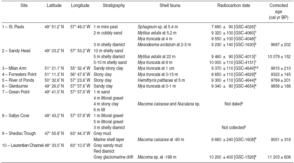
Note: Elevations are referred to present sea-level. Ages were calibrated using Fairbanks et al. (2005).
References: 1 – Blake (1986) 2 – Lowdon and Blake (1973) 3 – Guilbault (1984) 4 – McNeely and Jorgensen (1992) 5 – Brookes, field notes, 6 – Loring and Nota (1973).
Data is given in Table I on eight sites on the Northern Peninsula of Newfoundland, where cooling at 10 000-8000 yr BP is indicated, together with data for two sites offshore in Gulf of St. Lawrence, where we infer similar cooling. Sites 7 and 8 from Newfoundland were not dated, but are included because the stratigraphy and its inferred meaning are similar to the dated sites.
At St. Paul’s (Site 1, Fig. 1, Table I) a thin layer of pale grey, stony, uncompacted, clay-rich diamicton, roughly a metre thick, contains in situ shells of Mesodesma arctatum, 14C-dated 9230 ± 140 yr BP, and Mya truncata14C-dated at 9550 ± 100 yr BP. The tidewater glacier phase had ended on this coast by 12 000 yr BP, and sea-level at ~9000 yr BP was too low to float icebergs to this site (Brookes and Stevens, 1985 ; Grant, 1989), so the stony mud was explained as a small mass (a dropclot) affixed to the base of sea-ice which then became shore-fast (Blake, 1986).
At Sandy Head, Norris Point, Bonne Bay (Site 2, Fig. 1, Table I), in an otherwise sandy sequence, a soft, reddish, clayey diamicton, again roughly a metre thick, with shells 14C-dated at 9460 ± 90 yr BP, could not be explained (Blake, 1988), because shells in deglacial marine sediment at the head of this fjord gave ages of ~11 000 yr BP (Grant, 1988), ruling out iceberg calving in this fjord at 9400 yr BP.
Uncompacted stony clays at four other sites (Sites 3, 4, 5, and 6, Fig. 1, Table I) contain marine shell and foraminiferal assemblages with similar ages, each indicating cold Arctic conditions. These faunas are distinct from those from former glacier-proximal settings in west Newfoundland, and thus indicate glacier-free Arctic waters (Guilbault, 1984 ; McNeely and Jorgensen, 1992).
Mere regression of relative sea-level, causing grounding of sea-ice and deposition of stony mud, does not explain why these deposits are restricted to one stratigraphic position in each of the sequences studied, over an area where glacio-isostatic uplift differs by more than 150 m. It further begs the question as to the prevalence of sea-ice during the dated interval. These anomalous deposits, everywhere dating to the same interval, are found in a variety of topographic settings and elevations/depths, which asks too much if relative sea-level change is invoked in all cases.
In view of the regional cooling in the 10 000-8000 yr BP interval, inferred by Anderson and Lewis (1992), a more plausible explanation of these diamictons is that they were deposited by intensified ice-rafting in the Goldthwait Sea. It is envisaged that, during the climatic deterioration, diamictic sea-floor sediment became frozen to the underside of ice floes in shallow water. The floes were then driven ashore to ablate and release the diamict into off-lapping littoral gravel and sand. The foraminiferal zones in raised marine sediments at sites 3, 4, 5, and 6 (Fig. 1, Table I) require only a cooling of the marine environment to Arctic conditions from conditions that had become Boreal before ~9300 yr BP.
Contemporary glacigenic features
Moraines in long range mountains and Cape Breton Highlands
Further geological evidence of the cooling at 10 000-8000 yr BP may be found in the moraines formed around remnant plateau ice caps in northern Newfoundland. Waitt (1981) mapped two morainic belts on the northern plateau of the Long Range Mountains (Fig. 1) and referred them to cool intervals at 11 000-9000 yr BP, recorded isotopically in the Camp Century ice core (Dansgaard et al., 1971), and 9000-8000 yr BP, recorded by moraines in Greenland (Ten Brink and Weidick, 1974) and Arctic Canada (Andrews and Ives, 1972). Grant (1992) assigned both sets of moraines to a cold interval 10 000-8000 yr BP, because they are far inside the prominent moraine of the ~11 000 yr BP (Younger Dryas) Ten Mile Lake readvance.
A roughly circular pattern of discontinuous minor moraines on Cape Breton Highlands (Fig. 1) has also been referred to the 10 000-8000 yr BP interval, based on their position relative to dated lacustrine sequences (Phase H of Grant, 1994b : p. 124-125). If correlated correctly, these plateau moraines atop Long Range Mountains and Cape Breton Highlands indicate a climatic reversal severe enough to cause ice caps in retreat to stabilize or readvance. It is therefore likely that, in the neighbouring Goldthwait Sea, sea-ice also increased in thickness, extent and duration, producing layers of ice-rafted debris at the sites in northwestern Newfoundland.
Glacigenic sediments in laurentian channel
In the Gulf of St. Lawrence region, thin, stony layers also occur anomalously in offshore postglacial muds, and may indicate intensified ice-rafting. Connolly et al. (1967) reported two thin layers of coarse, red detritus in otherwise grey postglacial mud in several cores from outer Laurentian Channel (Fig. 1). These sediments are sands and granules, and contain arenaceous forams. They are only 10 cm thick, thinner down-Channel, and occur approximately in the middle of a 10-12 m mud sequence. Sedimentary particles in these layers were derived from Carboniferous red-beds in the southwest Gulf of St. Lawrence (Grant, unpublished data). The layers were considered to be till.
In view of the thinness of these coarse layers, as well as evidence for the establishment of marine conditions across the Goldthwait Sea by ~13 000 yr BP, and of no subsequent glacial readvances into Laurentian Channel, it is more likely that these coarse red sediments were deposited by bottom-melting of ice-floes drifting out of the Goldthwait Sea from debris-collection sites along coastlines that were rapidly approaching modern ones as sea-level rose. Their age was estimated at 13 000-15 000 yr BP by Connolly et al. (1967), but the beginning of sedimentation in 12 m-long sediment cores, acquired from Laurentian Channel nearby to the north, has been dated more recently to 14 000 yr BP (Rodrigues et al., 1993), approximately the time of deglaciation (Josenhans and Lehman, 1999). The position of the red sandy layers in mid-core would therefore more likely date them to 7000-10 000 yr BP. These layers, then, appear to represent two brief intervals early in the Holocene when coarse red sediment was introduced to a background of grey mud accumulating in deep water.
Solely on the basis of depth in core, these red layers may correlate with Unit GS-5 of Rodrigues et al. (1993), which they attributed to strong influx of high-salinity Atlantic bottom water into the Gulf. It is significant, therefore, that every unit of fresh water discharged into the Gulf at the surface causes about 30 times as much Atlantic saltwater in-draft at the bottom in order to maintain thermohaline equilibrium (Koutitonsky and Bugden, 1991). The red layers, therefore, could correspond to intervals of especially high freshwater discharge to the Gulf, as hypothesized for this time by Anderson and Lewis (1992). If so, more sea-ice would form, providing an agent for dispersal of red debris from the southwest Gulf to Laurentian Channel.
Glacigenic sediments in magdalen shallows
Two other puzzling occurrences were reported by Loring and Nota (1973) from Magdalen Shallows (Sites 9 and 10, Fig. 1, Table I). At site 9, wave-reworked till is overlain by marine bivalve shells 14C-dated to 8660 ± 240 yr BP, which are overlain by deep-water postglacial muds. At site 10, barren glaciomarine sediment is overlain by the same with shells that date to 10 200 yr BP. This, in turn, is overlain by 1.5 m of coarse, reddish-brown, sandy mud, regarded as till derived from Permo-Carboniferous red-beds in the local area. From this, Loring and Nota (1973) concluded that glaciers returned to the western Gulf between 10 200 and 8600 yr BP. Loring (1975) later interpreted the diamict layer above the 10 200 year date as Younger Dryas till.
Such a glacial readvance over the western Gulf of St. Lawrence, however, has heretofore been ruled out by occurrences of marine sediments in eastern New Brunswick and southern Gaspé Peninsula, Québec, dated to ≥12 000 yr BP, and not covered by glacial deposits (Dionne, 1977 ; Grant, 1989). Further, palaeoglacial maps (Grant, 1989 ; Dyke, 2004) show ice well inland by that time over the Gulf hinterland. Further, Stea et al. (1998) portrayed major deglaciation of the coastal zone of the western Gulf between 12 500 and 10 800 yr BP. Recently, however, Stea et al. (2003) have identified a distinctive till deposited by a residual ice cap over Prince Edward Island, overlying organic deposits containing woody debris reliably 14C-dated to 10 900-10 800 yr BP. The till is therefore of Younger Dryas age, but it is still too old to be correlated with the sandy mud recorded further offshore by Loring and Nota (1973). The occurrences which Loring and Nota (1973) and Loring (1975) called till are more likely to be ice-rafted sediment.
The Québec North Shore Morainic System (QNSMS)
An interpretation of these anomalous diamictic layers in Holocene marine geological contexts as iceberg-rafted can be discounted by showing that there were no contemporary calving glacier margins around the Gulf of St. Lawrence. East and west shores of the Gulf have been shown to have been deglaciated before 10 000-8000 yr BP. Along the North Shore, the only possible calving margin could be represented by the Québec North Shore Moraine System of Dubois and Dionne (1985), a more than 800 km-long ice-marginal complex, located 10 to 200 km inland (Fig. 1). The authors estimated its age at 9700-9500 yr BP, based on dated marine shell beyond it and gyttja inside it.
Based for the most part on this interpretation, the palaeoglacial reconstructions of Dyke and Prest (1987) and Dyke (2004) show little change in the Laurentide Ice Sheet margin along the QNSMS between 10 000 and 8500 yr BP, so whatever the reason for a still-stand of this margin of the Laurentide Ice Sheet, it took place almost entirely on land and thus could not have provided icebergs or glaciomarine drift to the Gulf. Dubois and Dionne (1985) acknowledged that formation of QNSMS may have reflected either external climatic or internal glacio-dynamic factors, but, significantly, they also pointed to evidence in the oxygen-isotopic composition of associated marine shell carbonate for marine cooling contemporary with moraine formation, reported by Hillaire-Marcel and Occhietti (1977).
Closest other tidewater ice margins at 10 000-8000 yr BP were in Lake Melville and Saguenay fjord. These are not only remote, but their sediments are unconnected stratigraphically and lithologically to the Gulf sequences discussed here. The Carboniferous red-bed origin of the coarse layers in the Gulf of St. Lawrence (Sites 9 and 10, Fig. 1, Table I) discounts a more northerly source, such as a calving Hudson Strait ice stream or floe ice developed over the Labrador Shelf, where no red-bed lithologies are known. Lithology of the red layers in the southern Gulf, considering plausible drift directions, also requires easterly transport from Magdalen Shallows, which would have been just submerged at 10 000-8000 yr BP (Shaw et al., 2002), and could thus have supplied red material for drift-ice dispersal to Laurentian Channel. The case against icebergs is elaborated in the Discussion section.
Discussion
Three points require discussion : the origin of the coarse (diamictic) layers, their dating, and the cause of the cooling. As for the first, icebergs can be dismissed as agents of transfer and deposition of the coarse layers since while bottom disturbance by icebergs is well known, they do not entrain bottom debris ; the lack of compaction of the diamicts discounts a subglacial origin ; we have noted the distances from contemporary ice margins of the anomalous coarse layers found in marine sequences ; also that early Holocene glacier readvances were restricted to interior highlands, thus severely ruling out iceberg sources.
Resedimentation of debris collected on the surface of an ice-foot can be dismissed since an ice-foot is a subaerial feature, whereas these diamicts host marine organisms (forams, bivalves). Ablation of an ice-foot would, furthermore, lead to fine sediment dispersal in the water column. Rather, the ice-rafting called for here is of stony marine mud frozen to the base of ice floes and resedimented upon grounding, very likely nearby, since prolonged transport would improve the chance of sediment dispersal. Although unlikely to be observed in modern environments, sub-floe rafting is inferred to have deposited a shore-level diamict in the St. Lawrence estuary, near Québec (Dionne, 1993).
As for dating, the average age of the anomalous layers at sites 1-6 (Fig. 1, Table I) is 9258 ± 108 yr BP (10 270 ± 140 cal yr BP). Omitting site 4, 400 to 500-years younger than the average, the average of dates from sites 1-3, 5, and 6 is 9340 ± 108 yr BP (10 550 ± 150 cal yr BP). Since the difference between these averages is less than the average standard deviation for both sets, it should be acceptable to average these two figures. This gives an overall average of 9300 yr BP (10 500 cal yr BP). Since ice-rafting is the preferred explanation for all of the marine geological contexts discussed here, each date should refer to a short interval, as should this average. It falls within the range 9600-8300 14C yr BP assigned to the cooler interval by Anderson and Lewis (1992). With specific reference to Newfoundland, these authors reported that shrub birch replaced only recently established spruce forests between 9700 and 8500 14C yr BP.
A reservoir correction must also be made to 14C age determinations on marine shell material found in the coarse layers. 14C dates from the Geological Survey of Canada (GSC) laboratory during the period when the samples described here were submitted were reported with a correction to the terrestrial standard, which reduced raw ages by 400 years, so that only the difference between the marine reservoir correction and 400 years need to be subtracted. As to the value of the correction, Dyke et al. (2003) gave preliminary values of 450 years for the southwestern Gulf of St. Lawrence, 610 years for the North Shore and St. Lawrence estuary, and 540 years for the northwest Atlantic, including Labrador Current. If, for the contexts reported here, the correction is taken as the average of values from the southwestern Gulf (450 years) and the North Shore (610 years) — i.e. 530 years, and if 400 years has been corrected for in laboratory reports, only 130 years needs to be subtracted from the conventional dates reported here. The average calibrated age of the coarse layers is thus reduced to 9170 yr BP (10 330 cal yr BP). This still lies within the cool period palynologically defined in the wider region, and more narrowly dated in Newfoundland. Only one date (Site 10) lies within the Younger Dryas interval, and only two samples (Sites 4 and 6) lie within the Pre-Boreal Oscillation.
As for the cause of the cooling, Anderson and Lewis (1992) related it to eastward discharge of glacial meltwater from Lake Agassiz through the Great Lakes-St. Lawrence River to the Gulf of St. Lawrence basin, citing Teller (1985, 1987, 1990) and Teller and Thorleifson (1983) for the chronology of deglaciation and meltwater routing. Ice-rafted diamicts and coarse layers at sites 1-7 in northwest Newfoundland, with reservoir-corrected dates averaging ~9170 yr BP are an expectable consequence of freezing of a freshwater lid on the Goldthwait Sea in Gulf of St. Lawrence basin.
Teller et al. (2002) produced a detailed chronology of Lake Agassiz overflows in which intervals of easterly discharge are given ages of 9400, 9300, 9200, 8900, 8500, and 8200 yr BP. Fisher et al. (2002) linked the North Atlantic cooling interval known as The Pre-Boreal Oscillation (PBO), ending at 9800 yr BP, to northerly overflow of Lake Agassiz water to the Arctic Ocean (via proto-Clearwater, proto-Athabasca, and proto-MacKenzie rivers) and compensatory surface outflow of freshened water from the Arctic Ocean to the Atlantic. But this is 600-700 years earlier than the (reservoir-corrected) average age of ~9170 yr BP (10 330 cal yr BP) for the geological contexts in Northwest Newfoundland referred to here. This average age is however coincident with one of the easterly overflows of Lake Agassiz identified by Teller et al. (2002 : p. 882, their Table I), specifically the Lower Campbell Stage (E).
As to correlation, in insular Newfoundland itself, marine sediment cores from inner Humber Arm, Bay of Islands, (south of site 6, Fig. 1) yielded dinoflagellate cysts and pollen which show that between 9500 and 8600 14C yr BP summer surface waters became much fresher as well as cooler by 3 to 7°C (Levac, 2003), and that local spruce forest was replaced by shrub-tundra between 9500 and 8500 14C yr BP, as Anderson and Lewis (1992) found over the wider region, and comfortably embracing the age of the cooling reported here. Extending this work, Anderson et al. (2007) recognize a cooling at ~9700 yr BP, in the Gulf and estuary of St. Lawrence, palynologically recognized, and correlate it with the Pre-Boreal Oscillation (PBO). They further recognize a cooling of the wider region contemporaneous with the 8200 cal yr event, probably related to release of glacial lake water and lingering glacial ice in Hudson Bay through Hudson Strait into the Labrador Sea. These authors apparently have not recognized a cooling at ~9200 yr BP, in evidence presented here, notwithstanding the earlier conclusion of Levac (2003).
Came et al. (2004), from paired planktonic foraminifera and Mg/Ca ratios in them, recognized the 8200 cal yr event over the subpolar North Atlantic, and interpret their data as showing similar cool conditions at 9300 years, an age similar to the cooling reported here. Andersen et al. (2004) used principal components analysis of diatom assemblages in cores from Reykjanes Ridge, southwest of Iceland, to reconstruct Holocene sea-surface temperatures. Warming from the Younger Dryas cooling is abruptly and deeply terminated by a cooling at ~9800 years (PBO), while a much smaller (~X 0.2) cooling at ~9300 years interrupts recovery from PBO, apparently correlative with the cooing reported here.
Given some uncertainty in the ages of the geological contexts reported herein (more dates and AMS-reduced standard deviation’s are required) exact correspondence of Lake Agassiz overflows and effects in the Goldthwait Sea should not be expected. It is also possible that, with repeated freshwater inputs to the Gulf of St. Lawrence between 9400 and 8200 14C yr BP (Teller et al., 2002), sea-ice conditions became progressively more severe through hysteresis.
Conclusion
Widespread palynological evidence of a sharp reversal to cooler climate in southeastern Canada at 10 000-8000 14C yr BP, reported by Anderson and Lewis (1992), is complemented here by dated sedimentological evidence of deposition of ice-rafted diamictons in the coastal marine waters of northwest Newfoundland and offshore in the central and western Gulf of St. Lawrence close to the middle of that interval. This implies a general decrease in average annual surface water temperature, for which there is indirect supporting evidence from planktonic micro-faunal assemblages, both in west Newfoundland (Guilbault, 1984 ; Levac, 2003) and in Laurentian Channel (Rodrigues et al., 1993). The average age for those contexts found above present sea-level is ~9300 yr BP (9170 yr BP with regional marine reservoir correction).
The inferred cool interval also may be related causally to glacier expansion (recessional still-stand), leading to moraine formation at the margin of the Labradorean sector of the Laurentide Ice Sheet (QSNMS) and small plateau ice caps on Newfoundland and Cape Breton Island. With no calving glaciers around the Gulf to account for the anomalous grey drop-stone muds in west Newfoundland and the red sandy layers in Laurentian Channel and Magdalen Shallows, we conclude that drift ice is the only alternative agent in the marine environment. Correspondence of the geologically defined cooling with one of six recently reported intervals of Lake Agassiz easterly overflow between 9400 and 8200 yr BP is speculative, given the coarse sampling of the stratigraphic contexts reported here. Notwithstanding, increased sea-ice extent may also have reflected the cumulative cooling effect of a group of these closely-spaced Agassiz-overflow events.
Appendices
Acknowledgements
First submitted in 1993, the paper aimed to present geological data which corroborated Anderson and Lewis’ work, and to offer an accordant explanation. In spite of reviewers’ recommendations, it has not seemed appropriate to argue our case further, based on more than ten years of subsequent work by others, which would convert our paper into more of a literature review than a data report. Since Grant died in 2003 and I am disabled, it is for others to re-examine these geological contexts, to add detail and more precise dating, perhaps alternative explanation. Previous submissions of this paper have meant that it has been read and commented on by many people, some anonymous, but including Jean-Claude Dionne, Université Laval, Québec, John Shaw and Mike Lewis, Geological Survey of Canada, Halifax. Thanks are extended to all and to the present reviewers and editorial staff.
References
- Andersen, C., Koc, N. and Morris, M., 2004. A highly unstable Holocene climate in the sub-polar North Atlantic : evidence from diatoms. Quaternary Science Reviews, 23 : 2155-2166.
- Anderson, T.W. and Lewis, C.F.M., 1992. Climatic influences of deglacial drainage in southern Canada at 10 to 8 ka suggested by pollen evidence. Géographie physique et Quaternaire, 46 : 255-272.
- Anderson, T.W., Levac, E. and Lewis, C.F.M., 2007. Cooling in the Gulf of St. Lawrence and estuary region at 9.7 to 7.2 14C ka (11.2-8.0 cal ka) : Palynological response to the PBO and 8.2 cal ka cold events, Laurentide Ice Sheet air mass circulation and enhanced freshwater runoff. Palaeogeography, Palaeoclimatology, Paleoecology, 246 : 75-100.
- Andrews, J.T. and Ives, J.D., 1972. Late and postglacial events (<10,000 BP) in the eastern Canadian Arctic with particular reference to the Cockburn Moraines and the break-up of the Laurentide Ice Sheet, p. 149-174. In Y. Vasari, H. Hyvarinen and S. Hicks, eds., Climatic Changes in Arctic Areas During the Last 10,000 Years. Universitet Ouluensis Acta, Series A, Scientiae Naturae, no. 3, Geologia, no. 1, 511 p.
- Blake, W. Jr., 1986. Geological Survey of Canada Radiocarbon Dates-XXV. Geological Survey of Canada, Ottawa, Paper 85-7.
- Blake, W. Jr., 1988. Geological Survey of Canada Radiocarbon Dates-XXVII. Geological Survey of Canada, Ottawa, Paper 97-7.
- Brookes, I.A., 1974. Late Wisconsin glaciation of southwestern Newfoundland (with special reference to the Stephenville map area). Geological Survey of Canada, Ottawa, Paper 73-40.
- Brookes, I.A. and Stevens, R.K., 1985. Radiocarbon age of rock-boring Hiatella arctica (Linne) and post-glacial sea-level change at Cow Head, Newfoundland. Canadian Journal of Earth Sciences, 22 : 136-140.
- Came, R.E., Oppo, D.W. and McManus, J.F., 2007. Amplitude and timing of temperature and salinity variability in the sub-polar North Atlantic over the past 10 ky. Geology, 35 : 315-318.
- Connolly, J.R., Needham, H.D. and Heezen, B.C., 1967. Late Pleistocene and Holocene sedimentation in the Laurentian channel. Journal of Geology, 75 : 131-147.
- Dansgaard, W., Johnsen, S.J., Clausen, H.B. and Langway, C.C., 1971. Climatic record revealed by the Camp Century ice core, p. 37-56. In K.K. Turekian, ed., The Late Cenozoic Glacial Ages. Yale University Press, New Haven, 606 p.
- Dionne, J.-C., 1977. La Mer de Goldthwait au Québec. Géographie physique et Quaternaire, 31 : 61-80.
- Dionne, J.-C., 1993. Sediment load of shore ice and ice rafting potential, upper St. Lawrence estuary, Quebec. Canadian Journal of Coastal Research, 9 : 628-646.
- Dubois, J.-M. and Dionne, J.-C., 1985. The Quebec North Shore Moraine System : a major feature of late Wisconsin deglaciation, p. 125-133. In H.W. Borns, Jr., P. LaSalle and W.B. Thompson, eds., Late Pleistocene History of Northeastern New England and Adjacent Quebec. Geological Society of America, Special Paper 197.
- Dyke, A.S., 2004. An outline of North American deglaciation with emphasis on central and northern Canada, p. 373-424. In J. Ehlers and P.L. Gibbard, eds., Quaternary Glaciations-Extent and Chronology, Vol. II, North America. Developments in Quaternary Science, Elsevier, Amsterdam, 450 p.
- Dyke, A.S. and Prest, V.K., 1987. Palaeogeography of northern North America, 18 000-5 000 years ago. Geological Survey of Canada, Ottawa, Map 1703A, 1 :12 500 000.
- Dyke, A.S., McNeely, R., Southon, J., Andrews, J.T., Peltier, W.R., Clague, J.J., England, J.H., Gagnon, J.-M. and Baldinger, A., 2003. Preliminary assessment of Canadian marine reservoir ages. Canadian Quaternary Association, 11th Biennial Meeting, Dalhousie University, Halifax, Nova Scotia, June 2003, Program and Abstracts : A23-A24.
- Fairbanks, R.G., Mortlock, R.A., Chiu, T.-C., Cao, L., Kaplan, A., Guilderson, T.P., Fairbanks, T.W. and Bloom, A. L., 2005. Quaternary Science Reviews, 24 : 1781-1796.
- Fisher, T.G., Smith, D.G. and Andrews, J.T., 2002. Pre-Boreal Oscillation caused by a Glacial Lake Agassiz flood. Quaternary Science Reviews, 21 : 873-878.
- Grant, D.R., 1988. Surficial geology, Sandy Lake-Bay of Islands, Newfoundland. Geological Survey of Canada, Ottawa, Map 1664A, 1 :250 000.
- Grant, D.R., 1989. Quaternary geology of the Atlantic Appalachian region of Canada, p. 391-440. In R.J. Fulton, ed., Quaternary Geology of Canada and Greenland. Geological Survey of Canada, Ottawa, Geology of Canada No. 1.
- Grant, D.R., 1992. Quaternary geology of St. Anthony-Blanc Sablon area, Newfoundland and Quebec. Geological Survey of Canada, Ottawa, Memoir 427.
- Grant, D.R., 1994a. Quaternary geology, Port Saunders map area, Newfoundland. Geological Survey of Canada, Ottawa, Paper 91-20.
- Grant, D.R., 1994b. Quaternary Geology, Cape Breton Island, Nova Scotia. Geological Survey of Canada, Ottawa, Bulletin 482.
- Guilbault, J.-P., 1984. Late glacial foraminiferal localities in raised marine sediments in western Newfoundland. Geological Survey of Canada, Ottawa, Open File Report 1003.
- Hillaire-Marcel, C. and Occhietti, S., 1977. Fréquence des datations au 14C de faunes marines postglaciaires de l’est du Canada et variations paléoclimatiques. Palaeogeography, Palaeoclimatology, Palaeoecology, 21 : 17-54.
- Josenhans, H. and Lehman, S., 1999. Quaternary stratigraphy and glacial history of the Gulf of St. Lawrence, Canada. Canadian Journal of Earth Sciences, 36, 1327-1345.
- Koutitonsky, V.G. and Bugden, G.L., 1991. The physical oceanography of the Gulf of St. Lawrence : a review with emphasis on the variability of the motion, p. 57-90. In J.-C. Theriault, ed., The Gulf of St. Lawrence : Small Ocean or Big Estuary ? Canadian Journal of Fisheries and Aquatic Sciences, 113.
- Levac, E., 2003. Detecting Holocene meltwater transit through the St. Lawrence River-Evidence from marine palynological records. Canadian Quaternary Association, 11th Biennial Meeting, Dalhousie University, Halifax, Nova Scotia, June 2003, Program and Abstracts : A61.
- Loring, D.H., 1975. Surficial geology of the Gulf of St. Lawrence, p. 11-34. In W.J.M. van den Linden and J.A. Wade, eds., Offshore Geology of Eastern Canada. Geological Survey Canada, Ottawa, Paper 74-30, vol. 2.
- Loring, D.H. and Nota, D.J.G., 1973. Morphology and sediments of the Gulf of St. Lawrence. Fisheries Research Board of Canada Bulletin, 182, 147 p.
- Lowdon, J.A. and Blake, W. Jr., 1973. Geological Survey of Canada Radiocarbon Dates-XIII. Geological Survey of Canada, Ottawa, Paper 73-7.
- McNeely, R. and Jorgensen, P.K., 1992. Geological Survey of Canada Radiocarbon Dates-XXX. Geological Survey of Canada, Ottawa, Paper 90-7.
- Rodrigues, C.G., Ceman, J.A. and Vilks, G., 1993. Late Quaternary palaeoceanography of deep and intermediate water masses off Gaspé Peninsula, Gulf of St. Lawrence : foraminiferal evidence. Canadian Journal of Earth Sciences, 30 : 1390-1403.
- Shaw, J., Gareau, P. and Courtney, R.C., 2002. Palaeogeography of Atlantic Canada 13-0 kyr. Quaternary Science Reviews, 21 : 1861-1878.
- Stea, R.R., Piper, D.J.W., Fader, G.B.J. and Boyd, R., 1998. Wisconsin glacial and sea-level history of Maritime Canada and the adjacent continental shelf : a correlation of land and sea events. Geological Society of America Bulletin, 110 : 821-845.
- Stea, R.R., Mott, R.J., Godfrey-Smith, D.I. and Fastook, J.L., 2003. Younger Dryas glacierization in the Gulf of St. Lawrence. Canadian Quaternary Association, 11th Biennial Meeting, Dalhousie University, Halifax, Nova Scotia, June 2003, Program and Abstracts : A114.
- Teller, J.T., 1985. Glacial Lake Agassiz and its influence on the Great Lakes, p. 1-16. In P.F. Karrow and P.E. Calkin, eds., Quaternary Evolution of the Great Lakes. Geological Association of Canada, Special Paper 30.
- Teller, J.T., 1987. Proglacial lakes and the southern margin of the Laurentide Ice Sheet, p. 39-69. In W.F. Ruddiman, H.E. Wright, Jr., eds., North America and Adjacent Oceans during the Last Deglaciation : Decade of North American Geology, vol. K-3. Geological Society of America, Boulder, 501 p.
- Teller, J.T., 1990. Volume and routing of late-glacial runoff from the southern Laurentide Ice Sheet. Quaternary Research, 34 : 12-23.
- Teller, J.T. and Thorleifson, L.H., 1983. The Lake Agassiz—Lake Superior connection, p. 261-290. In J.T. Teller, L.W. Clayton, eds., Glacial Lake Agassiz. Geological Association of Canada, Special Paper 26.
- Teller, J.T., Leverington, D.W. and Mann, J.D., 2002. Freshwater outbursts to the oceans from glacial Lake Agassiz and their role in climate change during the last deglaciation. Quaternary Science Reviews, 21 : 879-887.
- Ten Brink, N.W. and Weidick, A., 1974. Greenland ice sheet history since the last glaciation. Quaternary Research, 4 : 429-440.
- Waitt, R.B., 1981. Radial outflow and unsteady retreat of Late Wisconsin to early Holocene icecap in the northern Long Range upland, Newfoundland. Geological Society America Bulletin, 92 : 834-838.
 10.7202/032913ar
List of figures
Figure 1
Gulf of St. Lawrence and surrounding lands, showing features and sites mentioned in text.
Le Golfe du Saint-Laurent et les terres avoisinantes, montrant les éléments et les sites mentionnés dans le texte.
List of tables
Table I
Stratigraphy, shell fauna and radiocarbon dates for the selected sites
Note: Elevations are referred to present sea-level. Ages were calibrated using Fairbanks et al. (2005).
References: 1 – Blake (1986) 2 – Lowdon and Blake (1973) 3 – Guilbault (1984) 4 – McNeely and Jorgensen (1992) 5 – Brookes, field notes, 6 – Loring and Nota (1973).