Abstracts
Abstract
Researchers working in the Bow River valley have identified a minimum of four alluvial terraces, the upper two of which have been designated as paired terraces. Over the past 35 years, they have attempted to correlate these alluvial landforms and to generate models for the development of the terraces along the section of the Bow River between Calgary and the Rocky Mountains. In this study, Mazama ash and an early Holocene paleosol are used to correlate the terrace suites examined by previous researchers and to generate a model which accounts for the development of the upper two sets of paired terraces. These paired terraces reflect major episodes of aggradation and degradation that result from changes in independent variables such as climate and uplift. The initial episode of aggradation, dating from the late Pleistocene, is the result of paraglacial processes in a sparsely vegetated, yet saturated environment. Following a brief episode of degradation at the end of the Younger Dryas, the second episode of aggradation, dating from 9000 to 5000 BP, is caused by increased sediment load and lowered stream power during the Hypsithermal.
Résumé
Les chercheurs travaillant dans la vallée de la rivière Bow ont identifié au moins quatre terrasses alluviales, dont les deux supérieures ont été identifiées comme étant appariées. Au cours des 35 dernières années, ils ont essayé de corréler entre elles ces formes alluviales et d’élaborer des modèles appropriés à la formation des terrasses le long de la Bow River, entre Calgary et les Rocheuses. Dans la présente étude, les cendres de Mazama et un paléosol de l’Holocène inférieur ont servi à faire la corrélation entre les ensembles de terrasses étudiés précédemment et à élaborer un modèle pouvant expliquer la formation des deux ensembles supérieurs de terrasses appariées. Ces dernières résultent d’épisodes importants d’alluvionnement et de déblaiement qu’ont entraînées des modifications apportées à des phénomènes agissant de façon indépendante, comme le climat et le relèvement isostasique. Le premier épisode d’alluvionnement, survenu au Pléistocène supérieur, est le résultat de processus paraglaciaux agissant dans un milieu présentant une végétation clairsemée, bien que saturé. Après un court épisode de déblaiement à la fin du Dryas inférieur, le deuxième épisode d’alluvionnement (9000-5000 BP) est provoqué par une augmentation de la charge solide dans un cours d’eau de faible compétence, à l’Hypsithermal.
Resumen
Los estudios hechos en el valle del Bow River identifican por lo menos 4 terrazas fluviales, las dos terrazas superiores son consideradas terrazas apareadas. Durante los últimos 35 años se ha intentado relacionar estos relieves fluviales y generar modelos que permitan explicar la formación de terrazas a lo largo de la sección del Bow River entre Calgary y las Rocosas. En este estudio, las cenizas de Mazama y análisis de paleosuelos datando del Holoceno temprano han sido empleados para establecer una correlación de la serie de terrazas examinadas con anterioridad y así generar un modelo que explique la formación del conjunto de las terrazas superiores. Este par de terrazas refleja episodios importantes de sedimentación y pérdida de materiales como resultado de cambios en variables independientes tales como el clima y el elevamiento. El primer episodio de sedimentación data del Pleistoceno superior, y fue el resultado de un proceso paraglaciar acontecido en un ambiente escasamente cubierto de vegetación y sin embargo saturado. Después de un episodio breve de degradación al final del periodo de Younger Dryas, un segundo episodio de sedimentación (situado entre 9000 y 5000 años anteriores al presente) fue provocado por un incremento de la acumulación de sedimentos ocasionado por la disminución de la fuerza del cauce durante el Hypsithermal.
Article body
Introduction
Alluvial terraces or remnants thereof are differentially preserved in drainage basins of varying sizes and are often used by geomorphologists and archeologists to reconstruct the postglacial evolution of stream and river valleys in western Canada (e.g., Reeves, 1967; McPherson, 1968; Rains, 1969; Wilson, 1974; Stene, 1976, 1980; Welch, 1983; Wilson, 1983; Ryder and Church, 1986; Rains, 1987; Rains and Welch, 1988; Bryan et al., 1987; O’Hara and Campbell, 1993; Rains et al., 1994, Barling, 1995; Jackson, 1997). Although some of the early studies addressed structural concerns associated with dam construction (e.g., Pollock, 1962) or slope stabilization (e.g., Thomson and Townsend, 1979), most of the recent research focuses on the potential use of terraces as geomorphological indicators of Holocene environmental change (e.g., Brakenridge, 1980; Bryan et al., 1987; Rains and Welch, 1988; O’Hara and Campbell, 1993; Rains et al., 1994). That is, researchers attempt to relate episodes of erosion and deposition to changes in climate as inferred from proxy indicators such as pollen cores or lacustrine deposits (Jackson, 1997). While acknowledging a possible correlation between climate and terrace development, most researchers emphasize the lack of a direct relationship which they attribute to poor chronological controls and the complex nature of terrace formation.
Although the identification of terraces may seem relatively straightforward, identifying the processes responsible for the formation of those landforms is anything but simple. At a basic level, the formation of an alluvial terrace involves an episode of fluvial deposition followed by one of river incision (e.g., Thornbury, 1969). The factors and processes responsible for the episodes of deposition and incision, however, are numerous, complex, and variable from one drainage system to the next (e.g., Wolman and Leopold, 1957; Schumm and Lichty, 1963; Bull, 1988, 1990; Schumm, 1993; Blum and Straffin, 2001). For example, deposition may occur by channel aggradation, lateral accretion and/or overbank sedimentation. Further, these processes are influenced by local and regional controls such as geology, base level, channel morphology, sediment load, and water velocity. Similarly, episodes of incision vary in intensity and are controlled by variables such as changes in the water table, base level or water flow. Degradation can be triggered from both upstream and downstream directions but always results in channel incision with the concomitant removal of sediment and abandonment of the floodplain. Finally, sediment delivery to the system can be altered by any number of local, regional, or global changes in tectonics, isostatic and/or eustatic adjustments, and climate. More importantly, these changes can affect only part of the river system or rejuvenate the entire drainage network. To understand the evolution of fluvial landforms along a particular section of the river then, it is important to consider all factors influencing changes in discharge, sediment supply and sediment storage along both the upstream and downstream stretches of the drainage system.
According to a number of recent studies (e.g., Schumm and Brakenridge, 1987; Bull, 1988, 1990; Schumm, 1993; Blum and Törnqvist, 2000; Blum and Straffin, 2001), major episodes of aggradation or degradation are the result of changes in the threshold of critical power or the ratio of stream power over resisting power. That is, an increase in stream power relative to resisting power results in degradation whereas the inverse leads to aggradation. Variables that increase stream power and thus favour degradation include stable, vegetated hill slopes that yield very little sediment by processes of fluvial erosion or mass movement; increases in precipitation as measured by annual rainfall or by the frequency of high-intensity prolonged rainfalls; tectonic uplift that increases relief, drainage density, and longitudinal slopes of valley floors, and lowering of the relative base level. By contrast, aggradation generally is caused by the inability of a stream to transport all of its bedload due to decrease in stream discharge, and/or increase in amount and size of bedload. Variables that increase resisting power and thus favour aggradation include an abundance of stored sediment on unstable hillslopes; a decrease in vegetation cover resulting from climatic changes or fires; an increase in rainfall intensity; a lack of uplift, and a rise in relative base level.
The focus of this study is on the upper two, paired, late Pleistocene and early Holocene alluvial terraces along a section of the Bow River extending from the town of Cochrane to the city of Calgary. Although stratigraphic profiles and sediments within the different terraces are briefly described, the primary objective of this research is to correlate Stalker’s (1968a) terrace sequence in Cochrane with Wilson’s (1983) terrace suite in the city of Calgary. Although such correlations are normally based on relative elevations and large numbers of radiocarbon dates (e.g., Rains and Welch, 1988), this study relies on tephrochronology to establish the contemporaneity of specific terrace remnants along this 40-km section of the Bow River. Six stratigraphic profiles containing Mazama ash are used to demonstrate that Stalker’s (1968a) Terrace 4 is penecontemporaneous with Wilson’s (1983) T-3 terrace. The elevations, sediments, and published radiocarbon ages of higher terrace remnants adjacent to four of the sections are briefly described and presented. This information is then combined with data on isostatic rebound, base level, climate, vegetation, sediment supply and stream power to reconstruct the development of terraces along the Bow River Valley during the late Pleistocene and early Holocene. Briefly, two intervals of sediment accumulation and two episodes of sediment removal are identified for the interval between 12 000 and 5000 BP. In this and all subsequent discussions, dates are presented as uncalibrated radiocarbon years before present.
Previous Studies
Although early explorers and geologists have described the terraces along the Bow River (e.g., Dawson, 1885; Dawson and McConnell, 1895; Rutherford, 1927; Tharin, 1960), Stalker (1968a) was the first to conduct a systematic study of these alluvial landforms. He identified a sequence of eight terraces in the Cochrane area which, from oldest to youngest, were labeled as T-1 through T-8. The upper three terraces were identified as deltas formed by Bighill Creek as it emptied into Glacial Lake Calgary whereas Terraces 4 through 8 were interpreted as alluvial landforms created by the Bow River. To Stalker, the upper terraces were deposited along the shores of Glacial Lake Calgary sometime between 15 000 and 12 000 BP. Thereafter, the Bow River incised and then aggraded its bed to build the Bighill Creek Formation, a thick gravel and sand unit containing vertebrate fossils dating between 11 500 and 10 500 BP. Sometime after 10 000 BP, the river cut into the Bighill Creek Formation and formed the lower terraces identified at Cochrane.
Although several other researchers have examined the terraces along the Bow River (e.g., Churcher, 1968; Rutter, 1972; Roed and Wasylyk, 1973; Harris, 1977; Osborn, 1977; Smith, 1977; Wilson and Churcher, 1978; Jackson et al., 1982; Wilson and Churcher, 1984; Harris, 1985), only Wilson (1974, 1983) has provided a comparably detailed description of the late Pleistocene and Holocene terraces in the Calgary area. From oldest to youngest, these were identified as T-5 through T-1. In his study, Wilson identified the gravels of the Bighill Creek Formation and, based on dates obtained from the inclusive vertebrate fossils, argued that these sediments formed as the distal facies of an aggrading braided river sometime before 10 200 BP. Later, the river incised a channel into these gravels and formed the paired terrace remnants, which he identified as T-4. In the Calgary area, T-3 surfaces were also paired but had a thick layer of weakly banded silt overlying the basal gravels. These fine sediments, which consisted of silty clays to sandy silts, contained a band of Mazama ash and a pre-Mazama paleosol. According to Wilson (1983: 72), the T-3 fill accumulated sometime between 9500 and 5000 BP. Finally, the lower two terraces along this section of the Bow River were unpaired point bar slipoffs with capping overbank silts which formed sometime after 5000 BP.
In a series of publications, Harris (1977, 1985) and his colleagues (Harris and Boydell, 1972; Harris and Waters, 1977; Harris and Ciccone, 1983, 1986) provided an alternative explanation of late glacial and early postglacial events in southwestern Alberta and offered a competing interpretation for the development of terraces along this section of the Bow River. Harris (1985) noted a strong relationship between the elevations of the terraces and corresponding values for the bottoms of the Glacial Lake Calgary spillways. On the basis of this information, he concluded that the terraces formed during successive episodes of glacial lake drainage. In his opinion then, episodes of alluvial deposition were related to stable lake levels while periods of incision were associated with successive drops in base level as Glacial Lake Calgary drained through spillways at progressively lower elevations. According to this competing model, labeled the Glacial Lake Theory, most of the terraces along the Bow River between Cochrane and Calgary must have formed in a 2000-year interval between 10 000 and 8000 BP.
Methods
In 1998, an archeological investigation of an historic cemetery in Cochrane, Alberta uncovered evidence to help resolve these conflicting interpretations of terrace formation along the Bow River. During these excavations, a layer of Mazama ash was exposed in the walls of several graves approximately 1.9 m below surface. Since the graves dated from 1895 to 1905, the sediments incorporating the Mazama ash were obviously in primary contexts. More importantly, the historic cemetery was located on the grounds of the Nan Boothby Memorial Library (formerly St Mary’s Catholic Church) at the corner of 1st Avenue and 2nd Street in downtown Cochrane. As such, the cemetery was located on Stalker’s (1968a) T-4 terrace and offered a time-parallel marker for correlating the terraces in Cochrane with those identified by Wilson (1983) some 40 km downstream.
The layer of Mazama ash exposed in the historic cemetery occurred in fine-grained alluvial sediments overlying a gravel unit of unknown thickness. Although the gravels were not encountered during the archeological investigations, they were uncovered some 2.5 to 3 m below surface during the excavation of a nearby basement. In the Calgary area, the Mazama ash and a pre-Mazama paleosol occurred in 2 m of fine sediments overlying the basal gravels of Wilson’s T-3 terrace. The presence of Mazama ash indicates that these landforms are contemporaneous while the profiles suggest that the terraces formed under similar fluvial regimes. Of course, the correlation would be strengthened by locating and examining additional sections along the Bow River between Cochrane and Calgary. Further, it would be necessary to establish the fluvial origin of the respective landforms since the tephra and paleosol are also preserved in coalescent fans (Wilson, 1983: 219) and bluff edge dunes (e.g., Harrison, 1973; Wilson, 1983: 239; Oetelaar and Zaychuk, 1997) along the margins of the valley.
A total of six stratigraphic sections were recorded along the 40-km segment of the Bow River. The locations of the exposures are depicted in Figure 1 while the pertinent data are summarized in Table I. Of these, two were exposed in archeological excavations (Localities 1 and 6), two were examined along the banks of the river (Localities 2 and 5), one was based on the analysis of borehole data (Locality 4), and one was included in earlier reports (Locality 3). At each one of these locations, terraces at higher elevations were cursorily examined and are briefly described and discussed below. Figure 2 depicts the longitudinal profile of the river as well as the elevation of the T-3 terrace treads above the river. Stratigraphic sections for T-3 at each of the locations are included in Figure 2 while descriptions of the sedimentary units are summarized in Table II.
Results
Within the study area, there are, in fact, three sets of paired terraces at elevations of 60, 30 and 15 m above the Bow River although the elevation of the terrace treads relative to the river decreases somewhat downstream. The terrace treads identified in this study correspond to Wilson’s T-5 (60 m), T-4 (30 m) and T-3 (15 m) and to Stalker’s T-3 (60 m) and T-4 (20 m). Stalker (1968a) recognized T-4 as fluvial in origin but identified T-3 as a deltaic deposit whereas Wilson (1983: 192) considered T-5 and T-4 to “...represent, respectively, filltop and fillstrath terraces in the Bighill Creek Formation”. Although Wilson’s (1983) terminology (e.g., T-5, T-4, and T-3) is adopted in this study, the nature and genesis of T-5 remains uncertain and deserves further study. Similarly, for reasons of clarity, only representative type sections for each of these terraces are described below noting, where necessary, the variability observed along the river.
Figure 1

Map of the Bow River showing the location of the terraces and stratigraphic sections. 1-6 stratigraphic sections; T-3, T-4, T-5 terraces.
Carte de la Bow River montrant l’emplacement des terrasses et des coupes stratigraphiques. Coupes stratigraphiques 1-6 ; terrasses T-3, T-4 et T-5.
Table I
Locational and basic descriptive data for the stratigraphic sections at each locality discussed in this study

Figure 2

Longitudinal profile of the Bow River showing the relative elevations of T-3 terrace treads and upland ridges. Sedimentary units represented in the stratigraphic sections are also presented and correlated. Vertical scale on the sections is exaggerated.
Profil longitudinal de la Bow River montrant l’altitude relative des replats de la terrasse T-3 et des crêtes des collines. Les unités sédimentaires représentées dans les coupes stratigraphiques sont corrélées entre elles. L’échelle verticale au droit des coupes est exagérée.
Preserved remnants of the T-5 terrace are identifiable north of the river at Cochrane Heights (Stalker’s T-3), at the Bearspaw dam, and in Parkdale-West Hillhurst (Fig. 1). South of the river, T-5 occurs northeast of Springbank and south of Bowness in Calgary (Wilson, 1983: 192). In the Cochrane area, the surface of T-5 is approximately 60 m above the river while in the Calgary area the difference in elevation is slightly less than 60 m. Where present, these terraces consist of gravels overlain by a thin (ca. 30 cm) veneer of fine-grained sediments (Wilson, 1983: 192). Although no exposures were examined as part of this study, utility workers in Cochrane have reported the presence of gravels beneath a thin layer of silt in the Cochrane Heights area.
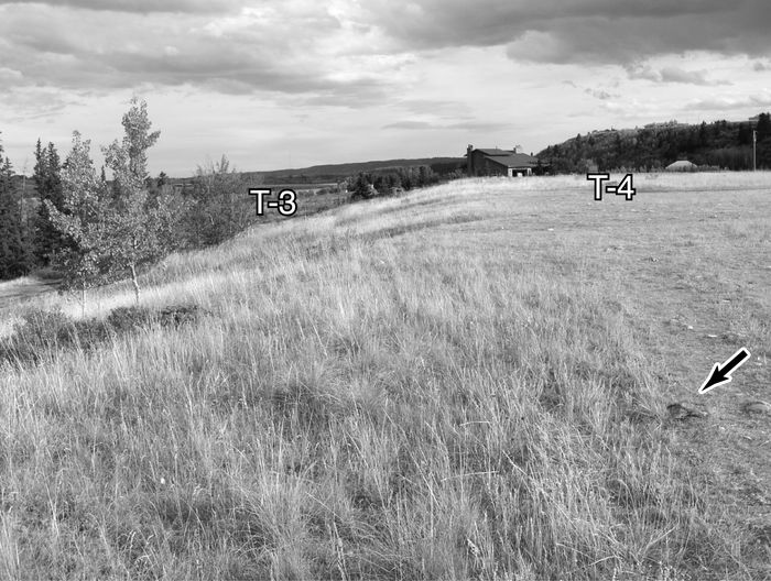
Remnants of the T-4 terrace occur on the north side of the river south of Bearspaw and in the Montgomery-Parkdale area of Calgary (Wilson, 1983: 192). South of the river, remnants of T-4 have been identified at Locality 2 and west of Locality 3 (this study) as well as in the Bowness area of Calgary (Wilson, 1983: 192). These terrace treads occur at 30 m above the level of the river although this vertical distance decreases downstream.
At Locality 2, the surface of the terrace is truncated by a number of relict channels reminiscent of a braided river. Here, the stratigraphic section includes moderately sorted gravels overlying bedrock some 10 m below the surface. The gravels are, in turn, capped by approximately 75 cm of fine-grained sediments, some of which display the massive structure typical of bluff edge dunes. The surface of the terrace next to Locality 3 has a broad, relatively deep, relict channel along the base of the upland slope and is dissected by several shallower depressions reminiscent of a braided system. The stratigraphic section at this location includes moderately sorted gravels overlying bedrock. A thin cap (<30 cm) of fine-grained sediment is often absent, especially in areas of high traffic, exposing the underlying gravel (Fig 3).
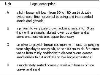
Table II
Descriptions of sedimentary units identified in the stratigraphic sections of the T-3 terrace
On the north side of the river, the T-3 terrace occurs in the town of Cochrane (Stalker’s T-4) at Locality 1 and near the filtration plant in Calgary at Locality 4. T-3 is also identifiable southwest of Glenbow at Locality 2, near the Bearspaw dam at Locality 3, at the Highway 1 crossing (Locality 5) and at the Mona Lisa site in downtown Calgary (Locality 6). In general, the surface of this terrace occurs approximately 15 m above the river although the relative elevation actually varies from 23 and 8.5 m. The stratigraphic profile of this terrace is best represented at Locality 5 where Highway 1 intersects the Bow River in northwest Calgary (Fig. 4). This type section has been examined and described by a number of authors but only Wilson (1974, 1983) published a description of the sediments. As a result, the ensuing discussion of the profile derives primarily from his published account and my personal observations.
The exposure along the bank of the river at Locality 5 is over 200 m long and includes 1.85 m of silt and sand overlying gravel. The gravel is moderately sorted with some interstitial silt and occasional silt and fine gravel lenses. This sedimentary unit, identified as Unit D in Table II, was encountered at four of the six stratigraphic sections. Although Unit D was not encountered at Locality 1 during the archeological investigations, this gravel layer was exposed at a depth of 2.5 to 3 m below surface during the excavation of a basement nearby. At Locality 3, gravel was not encountered even though the exposure extended 2.65 m below surface (Waters and Rutter, 1984). Despite this absence, Unit D is clearly identifiable as a coarse sediment that has, at minimum, been partially sorted by fluvial processes.
Where exposed, the overlying fine-grained sediments vary in thickness from a minimum of 0.96 m at Locality 5 to a maximum of approximately 2 m at Locality 6. As noted in Table II, a minimum of three sedimentary units, labeled Units C, B, and A, are represented in this portion of the stratigraphic profile. At Locality 5, Unit C is 0.86 m thick and consists of a light brown silt loam with evidence of bedding. Elsewhere, this sedimentary unit varies from 0.75 to 1.56 m in thickness and includes varying amounts of sand, silt and clay as well as low angle cross beds and cut and fill structures (Waters and Rutter, 1984). Again, the nature and structure of this deposit is consistent with deposition by fluvial processes.
At Locality 5, Unit C includes a very distinct, paleosol, located approximately 32 cm below the bottom of the ash (Fig. 4). Where present, the buried soil includes one (Localities 2 and 5), two (Locality 6) or three (Locality 3) closely spaced Ah horizons that appear to represent a complex of welded soil profiles. Such pedogenic units are interpreted as the result of episodic deposition by overbank floods followed by periods of stability and soil development (Blum and Straffin, 2001: 200). This early Holocene paleosol has been identified at a number of localities in the Calgary area and has yielded radiocarbon dates ranging from 8700 to 7700 BP (e.g., Harrison, 1973; Wilson, 1983; Waters and Rutter, 1984). In fact, a paleosol of this age and in a similar stratigraphic position has been noted at several localities across southern Alberta (e.g., Reeves and Dormaar, 1972; Dormaar, 1976; Valentine et al., 1987) and has been associated with an early Holocene episode of landscape stability (e.g., Sauchyn, 1990, 1993).
At Locality 5, the layer of Mazama ash is 7 cm thick and occurs approximately 0.97 m below the surface. Identified as Unit B, this tephra has been encountered in all of the sections examined. In this section of the Bow River valley, the ash layer is generally 7 to 10 cm thick and occurs a depths ranging from 0.96 to 2.0 m below surface. The tephra has been positively identified as Mazama ash in four of the six sections whereas the colour and thickness of the deposit at Localities 2 and 4 are consistent with this identification. Finally, the upper unit, or Unit A, at Locality 5 is a light brown silt loam with evidence of bedding. Interbedded lenses of clay, silt, sand and gravel are evident in all other exposures examined, indicating that this sedimentary unit is also of fluvial origin, probably the result of overbank deposition.
Discussion
The correlation of the stratigraphic sections along this 40 km segment of the Bow River challenges Harris’ (1985) model of terrace formation and provides only partial support for the fluvial model proposed by Stalker (1968a) and Wilson (1983). Before describing the model proposed in this study, it is perhaps informative to review briefly the interpretive framework of these earlier researchers. In the most recent synthesis of the data, Jackson et al. (1982) outline the following chronology of events leading to the formation of alluvial terraces along the Bow River from the Rocky Mountains to the city of Calgary. These researchers recognize an episode of incision sometime between 15 000 and 12 000 BP following the drainage of Glacial Lake Calgary. As mountain glaciers receded between 12 000 and 10 000 BP, mass movement of the unstable ice marginal deposits overloaded the mountain streams and delivered large quantities of coarse sediment to the major rivers including the Bow. During this interval, a braided river occupied the valley of the Bow and deposited the gravels of the Bighill Creek Formation. A decrease in sediment delivery approximately 9000 BP caused the river to change from an aggradational braided to a degradational meandering regime, a pattern which persisted until perhaps as late as 5500 or 5000 BP. By 4600 BP, the Bow River assumed its current quasi-stable, low-sinuosity, meandering, single-channel format and formed the lower unpaired terraces.
Figure 3
Photograph of the T-4 terrace west of Locality 3 showing cobbles (shown by arrow) exposed on the surface. View to the east.
Photographie de la terrasse T-4 à l’ouest du site no 3 montrant les pierres en surface (flèche). Vue vers l’est.
Figure 4

Photograph of the stratigraphic section at Locality 5 showing the Mazama ash and pre-Mazama paleosol. View to the west. Letters indicate sedimentary units.
Photographie de la coupe stratigraphique au site no 5 ; on y observe la cendre de Mazama et le paléosol de l’Holocène inférieur. Vue vers l’ouest. Les lettres identifient les unités sédimentaires.
Although these studies outline a general chronology of terrace formation, they do not address adequately the variables and processes responsible for the changes from aggradational to degradational regimes. To a great extent, this shortcoming reflects the state of the art at the time of their research. As indicated previously, our perspectives of and approaches to the study of river terraces have changed a great deal in the past twenty years. In particular, paired terraces are generally assumed to reflect major episodes of aggradation and degradation that result primarily from changes in independent variables such as climate and uplift (Bull 1988, 1990). If this is correct, then the formation of the paired terraces along this 40-km section of the Bow River should relate to changes in these variables. As noted below, such changes are well documented for the study area and do correlate well with the timing of terrace formation. In fact, it is possible to define two major episodes of aggradation and two intervals of degradation responsible for the formation of T-4 and T-3. Furthermore, the inferred ages for the changes in the threshold of critical power coincide with dramatic changes in climate, uplift, base level, vegetation, sediment load and stream discharge. The documented changes in these variables are summarized as follows.
Aggradation Episode 1
Chronology
For the reach under consideration in this research, the current river appears to flow in a preglacial valley carved in the local bedrock. The preglacial valley includes a minimum of two coarse gravel fills which vary somewhat in age and origin. The Saskatchewan Gravels and Sands (e.g., Stalker, 1968b), which have been identified in a number of river valleys in southern Alberta, represent a preglacial deposit that contains the remains of Pleistocene fauna dating between 45 000 and 20 000 BP (Stalker, 1968a; Wilson, 1983; Burns, 1996). The Bighill Creek Formation, in turn, contains poorly sorted gravels and sands with a similar assemblage of faunal remains, but dating between 12 000 and 10 000 BP (Burns, 1996). Although there are subtle differences between these alluvial gravels, often only the radiocarbon dates obtained on the samples of wood or bone allow researchers to segregate the sediments with any degree of confidence. This identification problem becomes particularly important when one attempts to use these data to determine the nature and age of the upper terrace along this section of the Bow River. However, the distribution of dated material within the valley clearly indicates an episode of incision into the Saskatchewan Gravels and Sands prior to the deposition of the Bighill Creek Formation (Churcher, 1968; Stalker, 1968a, Wilson and Churcher, 1978; Wilson, 1983). Given the age of the latter, this interval of degradation occurred sometime during the initial retreat of the Late Wisconsinan Laurentide Ice Sheet from this area. The incision of the river into the preglacial gravel was probably the result of isostatic rebound and water draining from glacial lakes. Based on the available radiocarbon ages from materials in the Bighill Creek Formation, the subsequent period of aggradation started sometime before 11 500 BP and, for reasons outlined later, lasted until 10 000 BP.
Climate
The interval between 11 000 and 10 000 BP is identified as an episode of slight Cordilleran glacial advance coeval with the Younger Dryas (Reasoner et al., 1994). In the Bow River Valley, for example, the Crowfoot Advance occurred between ca. 11 330 and 10 100 BP (Reasoner et al., 1994). The Cordilleran ice advance, although limited in extent, probably reduced the amount of meltwater delivered to the Bow drainage system. Similarly, in extreme northeastern Alberta, the Beaver River moraine was created by a Laurentide glacial readvance during the Younger Dryas cold interval (Fisher, 1993).
Isostacy
The glacial re-advance during the Younger Dryas would have decreased, even more, the rate of isostatic rebound which, at this point in time, was considerably slower than during the preceding episode of incision. That is, by 11 500 BP, the Cordilleran ice sheets had retreated to their present location in the mountains (Reasoner et al., 1994) while the margin of the continental ice sheet was located in the northeast corner of the province (Dyke and Prest, 1987). Similarly, many of the ice marginal and proglacial lakes in the province had drained before this date (St-Onge, 1972). As a result, the rate of isostatic uplift in the mountains and foothills was already in decline when the Cordilleran and continental ice sheets started to expand around 11 000 BP. The lowered rate of uplift in the upstream stretches of the drainage system at this time favoured net sediment accumulation. At the same time, the meltwaters accumulating in Glacial Lake Agassiz gradually increased the relative base level of the drainage system. When combined then, the lowered rate of isostatic rebound upstream and the higher relative base level downstream created a system favouring net sediment accumulation.
Vegetation
Pollen cores from mountain lakes indicate the presence of a sedge and grass community but one with sparse vegetation (Reasoner and Huber, 1999). At Crowfoot Lake, the pollen and macroscopic remains in Zone 1, dating from 11 330 to 10 100 BP, suggest a sparsely vegetated, unstable landscape associated with recently deglaciated terrain in the upper Bow Valley. Comparable vegetation communities are represented for roughly the same interval in pollen cores from Lake O’Hara (Reasoner and Hickman, 1989), Copper Lake and Kingfisher Pond (White, 1987), and Yamnuska Bog (MacDonald, 1982). In the Foothills at Toboggan Lake, the local vegetation at this time is generally sparse and dominated by herbs and shrubs, namely Artemisia and Gramineae (MacDonald, 1989). Further east, the few scattered pollen cores with early Holocene records indicate the presence of a community dominated by Picea and Artemisia (Ritchie, 1976). This sparsely vegetated landscape was susceptible to episodes of erosion which increased the sediment delivered to the drainage system.
Sediment load
During this interval, paraglacial activity was responsible for the delivery of substantial amounts of sediments into the mountain drainages as various ice-marginal deposits lost the physical support previously afforded by ice lobes (Jackson et al., 1982). The rapid delivery to the Bow (Fedje et al., 1995) and Kananaskis rivers of large volumes of sediment containing a significant coarse fraction overloaded these streams in terms of sediment load and clast size. The predictable hydrologic response of aggradation and braided channel development ensued, resulting in the deposition of the Bighill Creek Formation. Even though the wedges of coarse sediment extended down the valleys well beyond the mountains, unstable landscapes were also present in the foothills and plains. Here, the steepened slopes created by the ice and water adjusted to more stable profiles by mass-wasting, thereby increasing the sediment loads delivered to the lower reaches of the river (Wilson, 1983: 207-212). Stream discharge was adequate to flush out the fine-grained glacial lake sediments but left behind a large amount of coarse gravel in the Bow River valley. In short, paraglacial processes and erosion of the sparsely vegetated landscape increased the sediment load being delivered to the river system during this interval
Stream discharge
Even though the cooler climate reduced the amount of meltwater being generated by the ice sheets, a substantial amount of ground-water was still being contributed to the drainage system from the saturated sediments and the water trapped in ponds and lakes scattered across the landscape, especially in the mountains. Similarly, the sparse vegetation probably contributed to increased runoff especially during heavy rainfalls. Thus, stream power was still substantial, enabling the rivers and streams to transport sediment loads in excess of those observed today. That is, stream discharge was sufficient to remove the fine sediment and to displace the coarser materials downstream, particularly during flood episodes. Such coarse-grained channel belts are, in fact, characteristic of glacial period fluvial deposits (Blum and Straffin, 2001).
Summary
The decreasing rate of isostatic rebound and the increase in base level tended to flatten the longitudinal profile of the system during this interval. At the same time, the climate was responsible for a decrease in discharge and, by extension, stream power. Finally, the sparse vegetation and paraglacial activity combined to increase the sediment load introduced into the drainage system. When combined, these factors created a system favouring net sediment accumulation and were responsible for the episode of aggradation illustrated in Figure 5a.
Degradation Episode 1
Chronology
Since this episode represents an interval of net sediment removal or incision, the onset cannot precede the most recent date for the Bighill Creek Formation, the sedimentary unit deposited during the preceding interval. According to Wilson (1983: 189), the most recent acceptable date obtained on faunal remains recovered from the Bighill Creek Formation is 10 200 ± 280 BP (GSC-3065) or approximately 10 000 BP. Even though the sample of dated materials has increased significantly since 1980, the limiting dates for the Bighill Creek Formation have remained unchanged (Churcher, 1968; Burns, 1996; Kooyman et al., 2001). A date of 10 000 BP for the onset of this episode of degradation is also consistent with the dramatic change in climate marking the end of the Younger Dryas Chron (Dansgaard et al., 1989) and the concomitant changes in vegetation (MacDonald and McLeod, 1996). Finally, this episode of degradation is coincident with a dramatic lowering of the water level in Glacial Lake Agassiz at about 9900 BP (Smith and Fisher, 1993). For reasons discussed in a later section, this episode of incision was comparatively brief, ending sometime around 9000 BP.
Figure 5
A
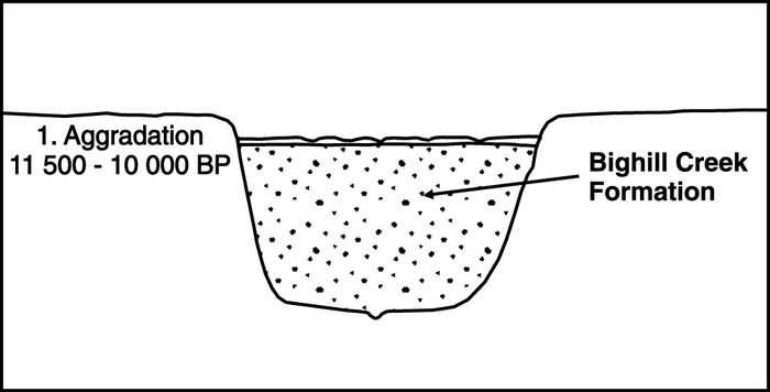
Schematic cross-section of the pre-glacial valley with Saskatchewan Gravels and Sands and the aggraded surface after deposition of Bighill Creek Formation.
Coupe schématique de la vallée pré-glaciaire montrant les Saskatchewan Gravels and Sands et la surface d’alluvionnement après le dépôt de la Formation de Bighill Creek.
B
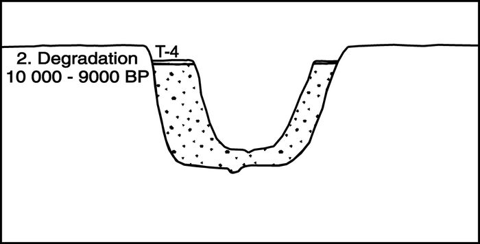
Schematic cross-section of the Bow River after the first episode of degradation.
Coupe schématique de la Bow River après le premier épisode de déblaiement.
C

Schematic cross-section of the Bow River after the episode of early Holocene aggradation.
Coupe schématique de la Bow River après l’épisode d’alluvionnement de l’Holocène inférieur.
D

Schematic cross-section of the Bow River today after the onset of the second episode of degradation. T-4, T-3, T-2, T-1 terraces.
Coupe schématique de la Bow River actuelle après le début du deuxième épisode de déblaiement. Terrasses T-4, T-3, T-2 et T-1.
Late Pleistocene and Holocene stratigraphic framework for the Bow River.
Cadre stratigraphique de la Bow River au Pléistocène supérieur et à l’Holocène.
Climate
Sometime around 10 000 BP, there was a rapid change in temperature associated with the end of the Younger Dryas Chron (Alley et al., 1993). In the cores from Crowfoot Lake, for example, the sandy clays deposited during the Crowfoot Advance are overlain by 18 cm of laminated gyttja with marl laminae in the lower 4 cm (Reasoner and Huber, 1999). According to these authors, the sudden change from clastic to organic sediments and the presence of a marl layer record the dramatic change in climate associated with the end of the Younger Dryas. Beierle (1997: 95-100; Beierle and Smith, 1998) noted similar changes in the sedimentary facies and the presence of a marl layer in a number of cores from lakes in the Bow River valley. He correlated the abrupt transition to organic sedimentation at 10 000 BP with the dramatic increase in temperature recorded in the DYE-3 Greenland ice core (Dansgaard et al., 1989) and the GISP-2 core (Alley et al.,1993). According to Beierle and Smith (1998), the dramatic increase in temperature recorded in the lake cores was coincident with decreases in precipitation and increases in surface evaporation.
Isostacy
According to Beierle (1997), the increase in temperature at the end of the Younger Dryas caused substantial ablation of the alpine glaciers. If this inference is correct, the sudden decrease in ice mass may have initiated a minor increase in the rate of isostatic rebound in the upper reaches of the drainage system. At approximately the same time, there is evidence for a dramatic drop in the level of Glacial Lake Agassiz which has been attributed to the opening of the northwest outlet (Fisher, 1993; Smith and Fisher, 1993; Fisher and Smith, 1994; Smith, 1994; Fisher and Souch, 1998). A series of radiocarbon dates from buried wood and peat in the lower Athabasca River valley suggest that the waters of Glacial Lake Agassiz breached the Beaver River moraine sometime around 9900 BP. The ensuing rapid drawdown lowered the level of Glacial Lake Agassiz by 52 m and, by extension, the base level for the Saskatchewan River and its tributaries, including the Bow River.
The change in base level as well as the rebound associated with the dramatic lowering of Glacial Lake Agassiz probably initiated an episode of incision but the extent of the degradation is equivocal. According to Leopold and Bull (1979), for example, a change in base level only affects the lower reaches of a river system. In Schumm’s (1993) opinion, a 50 m drop in base level is consistent with 45 m of incision near the coast but not with 30 m of incision 320 km inland from the coast. Conversely, Törnqvist (1998) has recently suggested that sea level changes have influenced terrace formation a distance of 400 km upstream of the shoreline. Finally, Blum and Törnqvist (2000) argue that the landward limit of incision, given a drop in relative base level, will not extend very far upstream unless sediment supply from upstream sources decreases such that degradation is also occurring in the upstream reaches of the system. In short, isostatic rebound and changes in relative base level during this interval were consistent with river incision although these conditions alone were obviously not sufficient to cause the degree of down-cutting represented in Figure 5b.
Vegetation
The dramatic change recorded in the stratigraphy of the lake cores is reflected by a sudden change in vegetation. In Crowfoot Lake, for example, the interval beginning at 10 100 BP (Reasoner and Huber, 1999) represents the stabilization of the landscape and the appearance of abundant forest vegetation in the vicinity of the lake as indicated by the presence of macroscopic remains from spruce. This early Pinus-dominated forest included persistent areas of open vegetation. A similar pattern is evident at Lake O’Hara (Reasoner and Hickman, 1989), Copper Lake and Kingfisher Pond (White, 1987), Yamnuska Bog and Wedge Lake (MacDonald, 1982). Together, these palaeoenvironmental reconstructions from alpine sites in western Canada indicate that the interval from 10 000 to 7000 BP was a period of relative warmth associated with elevated alpine timberlines. Shortly after 10 000 BP, arboreal vegetation became dominant in the Foothills at Toboggan Lake (MacDonald 1989) but less common on the Plains further downstream (Barnosky et al., 1987; Sauchyn and Sauchyn, 1991). Nevertheless, trees were very common around prairie potholes for a very brief interval around 10 000 BP (Beaudoin, 1992; Yansa, 1998; Yansa and Basinger, 1999).
Sediment load
By 10 000 BP, many of the mountain slopes had attained relatively stable profiles thereby moderating the effects of paraglacial activity (Jackson et al., 1982). At the same time, the sudden appearance of forest vegetation, especially in the mountains and foothills, served to stabilize the landscape and reduce the amount of sediment being introduced into the drainages. In the mountains then, sediment delivery was restricted to small alluvial fans at the heads of streams whereas, in the Foothills and the Plains, very little material was being added to the waterways. This decrease in sediment load is also represented as a change from clastic to organic sediments in the cores of subalpine lakes (Beierle and Smith, 1998). In short, the stable slopes and vegetation cover combined to reduce the sediment load being delivered to the Bow River at this time.
Stream discharge
The interval between 10 000 and 9000 BP was a time of maximum summer insolation in the northern hemisphere and, by extension, a period of maximum aridity characterized by decreased precipitation and increased evaporation (Kutzbach and Guetter, 1986). This interval also represents the winter insolation minimum but it is unknown whether or not the colder winters were characterized by greater snowfall. The arboreal vegetation present on the slopes of the mountains and in the neighbouring Foothills is, at least, consistent with an increase in winter precipitation during this interval. At the same time, the dramatic increase in temperature at the end of the Younger Dryas may have caused substantial ablation of alpine glaciers (Beierle, 1997; Beierle and Smith, 1998). The resultant increase in meltwater runoff would have raised the levels of the mountain lakes, many of which were created by debris flows and alluvial fan development. The addition of water to these mountain reservoirs, especially during spring runoff following late winter snowstorms (Bull, 1988; Stene, 1976), could have caused lakes to breach their dams and thus initiate a period of rapid incision. The erosive power of the Bow River would have been substantially increased as the flood waters caused successive dams to fail. This sequence of events could have initiated the episode of down-cutting inferred for this interval.
Summary
The stable, forested mountain slopes contributed little sediment to the system while the melting of the alpine glaciers increased the rate of discharge, at least seasonally. The increased runoff probably caused one or more of the dammed reservoirs to fail, thereby initiating one or more floods capable of substantial erosion. While these variables were affecting the upstream reaches of the Bow system, the dramatic drop in base level as Glacial Lake Agassiz drained through the northwest outlet would have caused the lower reaches to go through the same episode of degradation. The net result was a 1000-year interval during which the Bow River incised a new channel into the previously deposited gravels and sands of the Bighill Creek Formation (Fig. 5b).
Aggradation Episode 2
Chronology
The chronology for the onset of this interval is based primarily on the earliest dates from the T-3 terrace deposits. This set of paired terraces contains a layer of Mazama ash, dated at 6730 BP (Hallett et al., 1997), and an early Holocene paleosol. In the sections examined, the tephra normally occurs approximately 1 to 2 m below the surface and a comparable distance above the basal gravels (Fig. 2). Similarly, the paleosol occurs from 10 to 50 cm below the ash and has been dated at 8000 to 8500 BP (e.g., Harrison, 1973; Wilson, 1983; Waters and Rutter, 1984). The presence of the ash and paleosol in most of the sections examined suggests that this alluvial fill started to accumulate sometime before 8500 BP. Downstream, the level of Glacial Lake Agassiz may have stabilized or risen slightly as the northwest outlet cut down to bedrock sometime around 9100 BP (Fisher and Souch, 1998). On the basis of this evidence, it is suggested that the second episode of aggradation started at about 9000 BP and, for reasons noted later, lasted until sometime around 5000 BP.
Climate
The Holocene Thermal Maximum or Hypsithermal persisted throughout most of this interval. In middle northern latitudes, precipitation increased around 9000 BP but evaporation increased even more, leading to soil-moisture deficits (Kutzbach and Guetter, 1986). In the mountains and in central Alberta, maximum aridity occurred at the beginning of the interval (Schweger and Hickman, 1989; Beierle and Smith, 1998) whereas further east the episode of moisture deficit lasted from 9000 to 6000 BP (Vance, 1986) with the greatest drought being recorded from 7700 to 6800 BP (Sauchyn and Sauchyn, 1991). In the mountains and foothills of Alberta, water levels in closed basin lakes dropped by 6 m, presumably reflecting a lowering of the water table and moisture deficits resulting from decreases in precipitation or increases in evaporation (Beierle, 1997; Beierle and Smith, 1998). In central Alberta at this time, shallow basin lakes began flooding as early as 7500 BP but salinity remained high as a result of continued high evaporation rates (Schweger and Hickman, 1989). Similar moisture deficits were recorded as dramatic changes in water levels within the deep basin lakes of the area (Schweger and Hickman, 1989). In short, the interval between 9000 and 5000 BP is best characterized as one of moisture deficits arising primarily from the high rates of evaporation.
Isostacy
By 9000 BP, the rate of isostatic rebound had probably abated somewhat and thus had limited influence on the upstream stretches of the drainage basin. Initially, the lower reaches of the river system may have been affected by minor fluctuations in the level of Glacial Lake Agassiz but the lake had drained by 8000 BP (Teller and Thorleifson,1983). Thereafter, the downstream stretches of the drainage were influenced by the combined effects of isostatic rebound in the recently deglaciated Canadian Shield and the eustatic rise in sea level. In general, however, the effects of isostatic rebound were much less than those experienced during the earlier intervals.
Vegetation
The persistence of the thermal maximum throughout most of this interval affected the local and regional vegetation. In the mountain valleys, for example, the treeline attained its highest level between 8500 and 7000 BP (Reasoner and Hickman, 1989) whereas a gradual replacement of forest by prairie occurred in the Foothills between 8500 and 5000 BP (e.g., MacDonald, 1989). In the Parklands, grass pollen becomes increasingly common in the Lofty Lake core between 9000 and 6000 BP (Vance, 1986) whereas a similar change in vegetation is recorded in the Harris Lake core for the interval dating between 7700 and 6800 BP. The interval between 9000 and 5000 BP thus represents an episode of grassland expansion at the expense of the forest, although the continued high evaporation rates also contributed to a decrease in vegetation cover. The pollen records also indicate that fire became an important agent of disturbance as early as 9000 BP. Whether or not these fires were of natural or human origin remains uncertain but they did influence the nature and density of vegetation in the area.
Sediment load
At the same time, the sediment load was increasing in two separate stages. Initially, the unstable slopes created by the rapid down-cutting of the previous episode achieved stable profiles through mass wasting (Wilson, 1983: 207). These processes contributed primarily coarse gravels from the oversteepened banks. Shortly thereafter, glacial lake sediments from the neighbouring uplands were added to the sediment load as the network of tributary streams started to develop or reoccupied their preglacial valleys (Welch, 1983; Rains and Welch, 1988). A similar trend is evident in the mountains where many of the alluvial fans contain a layer of Mazama ash near their surfaces (Roed and Wasylyk, 1973). Although some of the coarser materials in the fans related to earlier episodes of paraglacial activity, the near-surface deposits derived mainly from erosional processes within the valleys. Following this episode of slope adjustment, the river valley was relatively stable for some time as indicated by the paleosol. Thereafter, a second interval of net sediment accumulation occurred that reflected primarily the change in plant communities and the decrease in vegetation cover (Sauchyn, 1990). When combined with the increased incidence of fires, these changes in vegetation accelerated the rate of erosion and thus contributed additional fine-grained sediment to the drainage system. That the surface deposits were prone to erosion during this interval is evident from the presence of bluff edge dunes with layers of Mazama ash along the margins of the Bow River valley (Oetelaar et al., 1996; Oetelaar and Boyd, 1997; Oetelaar and Zaychuk, 1997; Oetelaar and Gillespie, 2001). In summary then, the unstable slopes, the establishment of upland drainages, and the nature of the vegetation cover combined to increase the rate of sediment delivery to the various reaches of the drainage system during the interval from 9000 to 5000 BP.
Stream discharge
By 9000 BP, the alpine glaciers were substantially smaller and most of the mountain reservoirs had drained. Thus, the rate of discharge depended largely on runoff from precipitation which also had decreased as indicated by the water levels in the mountain lakes (Beierle and Smith, 1998). Similarly, the lowered lake levels in central Alberta indicate a moisture deficit, even though precipitation increased during this interval primarily as summer storms (Schweger and Hickman, 1989). As a result, stream power was inadequate to remove the slowly accumulating sediment or even to move the fine sediments very far downstream.
Summary
During this interval, the relatively arid climate decreased both vegetation cover and stream power. The sparse vegetation cover increased sediment load which, when combined with the decrease in stream power, effectively reduced the ability of the river to remove the sediment from the system. As a result, the sediment load was deposited on the floodplain, primarily in the form of overbank deposits (Fig. 5c). Again, such thick accumulations of fine-grained sediments are common on terraces formed during the Holocene (Brakenridge, 1980; Blum and Straffin, 2001).
Degradation Episode 2
Chronology
Although limited in number, the radiocarbon dates currently available suggest that the subsequent episode of river incision started somewhere around 5000 BP (Jackson et al., 1982; Wilson, 1983). The majority of the dates derive from materials collected during the excavation of archeological sites discovered on the lower unpaired T-2 terraces in the Calgary area (Wilson, 1983). The samples, however, were recovered from intact, buried cultural layers with good stratigraphic association and the dates of 4600 BP are consistent with a date of 5000 BP for the onset of incision.
Climate
The relatively arid conditions of the preceding interval started to abate by 6000 BP but the return to a cooler, wetter climate appears to have been time-transgressive beginning at 5500 BP around Toboggan Lake (MacDonald, 1989) and at 5000 BP in the vicinity of Harris Lake (Sauchyn and Sauchyn, 1991). Wetter conditions are also apparent in central Alberta where shallow lakes experienced a peak in flooding between 5000 and 4000 BP. By contrast, Vance’s (1986) calibration of the pollen record and simulation of precipitation patterns suggest only a slight increase in precipitation around 4000 BP but an obvious cooling trend at about the same time. As a result, less of the precipitation would have been lost to the system through evaporation.
Isostacy
There is, in fact, very little evidence for isostatic uplift in the upper reaches of the drainage or for changes in relative base level within the lower stretches of the river. Under these circumstances, rivers adjust to fluctuations in sediment load and stream discharge through changes in channel configuration and river morphology (Schumm, 1993). That is, rivers tend to adjust by lateral incision and increased sinuosity, processes that favour the formation of complex response terraces, most of which are unpaired (Bull, 1990).
Vegetation
In the mountains, essentially modern plant communities become established around 5000 BP (Luckman and Kearney, 1986; Reasoner and Huber, 1999) although there is evidence for a neoglacial advance starting approximately 3000 BP (Reasoner and Hickman, 1989). A similar pattern is recorded for the Foothills (MacDonald, 1989) while Sauchyn and Sauchyn (1991) document increases in forest cover around Harris Lake starting as early as 5000 BP.
Sediment load
During this interval, the mountain slopes were stable and covered with forests except for the presence of alpine meadows and clearings being maintained by fire. By this time, alluvial fans were growing at a slower pace and thus contributed little sediment to the drainages. In the Foothills and on the Plains, most of the slopes had attained stable profiles and the neighbouring uplands were covered with vegetation. As a result, the delivery of sediment to the drainages was limited, with perhaps occasional fluctuations resulting from landslides and summer storms.
Stream discharge
The increase in precipitation obviously served to increase the rate of discharge but the change was not adequate to initiate a major episode of down-cutting. Instead, stream discharge was sufficient to remove the sediment being introduced into the system and to lower the stream bed gradually by incision.
Summary
During the past 5000 years, the Bow River appears to have approximated a state of equilibrium where the variables influencing degradation only marginally exceeded those favouring aggradation. The river has adjusted to these slight changes in stream power and resisting power by lateral migration and incision, resulting in the formation of unpaired terraces (Fig. 5d).
Conclusion
This study has identified a minimum of three paired terraces along a reach of the Bow River extending from Cochrane to Calgary, Alberta. Of these, the upper two sets occur at elevations of 60 and 30 m above the level of the river and, based on the inclusive faunal remains, date to the interval from 12 000 to 10 000 BP. The stratigraphic profiles reveal thick gravel layers overlain by thin veneers of alluvium and loess. The surfaces of these terraces often are dissected by relict channels of a braided river. The third set of paired terraces occurs at elevations of 15 m above the level of the river and date to the interval between 9000 and 5000 BP. The stratigraphic profiles consist of basal gravels overlain by two or more metres of fine-grained sediments that include a layer of Mazama ash and a pre-Mazama paleosol. The sedimentology of the fine-grained sediment is consistent with aggradation by overbank deposition although there are also signs of lateral accretion.
On the basis of this evidence, it is argued that the paired terraces along this stretch of the Bow River represent, at least, two major episodes of degradation and aggradation by the river. Following an early episode of incision by meltwater, the Bow River aggraded its bed during the interval between 11 500 and 10 000 BP. Thereafter, the river incised a relatively deep channel during a brief interval lasting from 10 000 to perhaps 9000 BP, before again aggrading its bed between 9000 and 5000 BP. At this time, the river began its latest episode of gradual incision which has continued to the present. This basic outline of the chronology of terrace formation is generally comparable to that proposed by Wilson (1983) two decades ago. However, this study actually correlates the terraces identified by Wilson (1983) and by Stalker (1968a), thereby demonstrating that the variables and processes responsible for these changes from aggradation to degradation affected a long stretch of the river.
Recent research on the formation of terraces suggests that the presence of paired terraces over long stretches of a river tend to reflect changes in independent variables or external forcing mechanisms such as climate change, glaciation, isostatic rebound and relative base level. As a result, this study has used current information on local and regional changes in isostatic rebound, base level, and climate to develop a model for the formation of terraces along the river. The results suggest that each of the major episodes of aggradation and degradation corresponds to dramatic changes in climate, isostatic rebound, relative base level, vegetation, sediment load and stream discharge. When combined, these variables help explain the processes responsible for the formation of paired terraces along the Bow River and thus allow us to relate Wilson’s (1983) chronological framework to changes in the surrounding landscape.
Appendices
Acknowledgements
I would like to thank Steve Wolfe and Garry Running IV for the opportunity to present a paper at the GAC conference and for their indulgence and assistance in preparing the manuscript for publication. I also want to acknowledge the helpful comments from the external reviewers, D.H. de Boer and R.B. Rains. Of course, I alone am responsible for any errors of fact or interpretation. Illustrations and translations were capably completed by Dominique Cossu. Financial support for the archeological investigations was provided by the University of Calgary, Carma Developers Ltd. and the Town of Cochrane. Finally, the preparation of the conference presentation and the resulting manuscript would not have been possible without a generous grant (412-1999-1000) from the Social Sciences and Humanities Research Council of Canada.
References
- Alley, R.B., Meese, D.A., Shuman, C.A., Gow, A.J., Taylor, G.C., Grootes, P.M., White, J.W.C., Ram, F.D., Waddington, E.D., Mayewski, P.A. and Zielinski, G.A., 1993. Abrupt increase in Greenland snow accumulation at the end of the Younger Dryas event. Nature, 362: 527-529.
- Barling, M., 1995. The Geomorphology and Alluvial History of Matzhiwin Creek, a Small Tributary of the Red Deer River in Southern Alberta. M.Sc. thesis, Department of Geography, University of Alberta, Edmonton,125 p.
- Barnosky, C.W., Grimm, E.C. and Wright, Jr., H.E., 1987. Towards a postglacial history of the northern Great Plains: A review of the paleoecologic problems. Annals of the Carnegie Museum, 56: 259-273.
- Beaudoin, A.B., 1992. Early Holocene palaeo-environmental data preserved in “non-traditional” sites. The 2nd Palliser Triangle Global Change Conference (Regina, Saskatchewan), Program with Abstracts, p. 1-2.
- Beierle, B.D., 1997. Early Holocene Climate of Southwestern Alberta, Canada, Reconstructed from Lake Sediment Cores. M.Sc. thesis, Department of Geography, University of Calgary, 115 p.
- Beierle, B.D. and Smith, D.G., 1998. Severe drought in the Early Holocene (10,000-6800 BP) interpreted from lake sediment cores, southwestern Alberta, Canada. Palaeogeography, Palaeoclimatology, Palaeoecology, 140: 75-83.
- Blum, M.D. and Straffin, E.C., 2001. Fluvial responses to external forcing: Examples from the French Massif Central, the Texas Coastal Plain (USA), the Sahara of Tunisia, and the Lower Mississippi Valley (USA), p. 195-228. In D. Maddy, M.G. Maeklin and J.C. Woodward, eds., River Basin Sediment Systems: Archives of Environmental Change. A.A. Balkema, Lisse, 503 p.
- Blum, M.D. and Törnqvist, T.E., 2000. Fluvial responses to climate and sea-level change: A review and look forward. Sedimentology (Supplement 1), 47: 2-48.
- Brakenridge, G.R., 1980. Widespread episodes of stream erosion during the Holocene and their climatic cause. Nature, 283: 655-656.
- Bryan, R.B., Campbell, I.A. and Yair, A., 1987. Postglacial geomorphic development of the Dinosaur Provincial Park badlands, Alberta. Canadian Journal of Earth Sciences, 24: 135-146.
- Bull, W.B., 1988. Floods: Degradation and aggradation, p. 157-165. In V.R. Baker, R.C. Kochel and P.C. Patton, eds., Flood Geomorphology. John Wiley, New York, 503 p.
- _____ 1990. Stream-terrace genesis: Implications for soil development. Geomorphology, 3: 351-367.
- Burns, J.A., 1996. Vertebrate paleontology and the alleged ice-free corridor: The meat of the matter. Quaternary International, 32: 107-112.
- Churcher, C.S., 1968. Pleistocene ungulates from the Bow River gravels at Cochrane, Alberta. Canadian Journal of Earth Sciences, 5: 1467-1488.
- Dansgaard, W., White, J.W.C. and Johnsen S.J., 1989. The abrupt termination of the Younger Dryas climate event. Nature, 339: 532-533.
- Dawson, G.M., 1885. Report on the region in the vicinity of Bow and Belly Rivers, North West Territories. Geological and Natural History Survey of Canada, Report of Progress, 1882-1883-1884: 1C-169C.
- Dawson, G.M. and McConnell, R.G., 1895. Glacial deposits of southwestern Alberta in the vicinity of the Rocky Mountains. Bulletin of the Geological Society of America, 7: 31- 66.
- Dormaar, J.F., 1976. Paleosol studies in western Canada, p.209-221. In W.C. Mahaney, ed., Quaternary Soils. Geo Abstracts, Norwich, 508 p.
- Dyke, A.S. and Prest, V.K., 1987. Late Wisconsinan and Holocene retreat of the Laurentide Ice Sheet. Geological Survey of Canada, Ottawa, Map 1702A.
- Fedje, D.W., White, J.M., Wilson, M.C., Nelson, D.E., Vogel, J.S. and Southon, J.R., 1995. Vermilion Lakes site: Adaptations and environments in the Canadian Rockies during the latest Pleistocene and early Holocene. American Antiquity, 60: 81-108.
- Fisher, T.G., 1993. Glacial Lake Agassiz: The Northwest Outlet and Paleoflood Spillway, N.W. Saskatchewan and N.E. Alberta. Ph.D. thesis, University of Calgary, 184 p.
- Fisher, T.G. and Smith, D.G., 1994. Glacial Lake Agassiz: Its northwest maximum extent and outlet in Saskatchewan (Emerson Phase). Quaternary Science Reviews, 13: 845-858.
- Fisher, T.G. and Souch, C., 1998. Northwest outlet channels of Lake Agassiz, isostatic tilting and a migrating continental drainage divide, Saskatchewan, Canada. Geomorphology, 25: 57-73.
- Hallett, D.J., Hills, L.V. and Clague, J.J., 1997. New accelerator mass spectrometry radiocarbon ages for the Mazama tephra layer from Kootenay National Park, British Columbia, Canada. Canadian Journal of Earth Sciences, 34: 1202-1209.
- Harris, S.A., 1977. Late Quaternary history of the Bow Valley, p.12-23. In D.G. Smith and S.A. Harris, eds., Geomorphology of Banff Park and Columbia Icefield. Department of Geography, University of Calgary, 57 p.
- _____ 1985. Evidence for the nature of the early Holocene climate and paleo-geography, High Plains, Alberta, Canada. Arctic and Alpine Research, 17: 49-67.
- Harris, S.A. and Boydell, A.N., 1972. Glacial history of the Bow River and Red Deer River areas and the adjacent Foothills, p.47-53. In H.O. Slaymaker and J.J. McPherson, eds., Mountain Geomorphology: Geomorphological Processes in the Canadian Cordillera. Tantalus Research, Vancouver, 274 p.
- Harris, S.A. and Ciccone, B., 1983. Palaeoecology and palaeogeography near Cochrane, Alberta, Canada, just after the last major high stand of Glacial Lake Calgary. Palaeogeography, Palaeoclimatology, Palaeoecology, 41: 175-192.
- _____ 1986. Reply to comments on “Palaeoecology and palaeogeography near Cochrane, Alberta, Canada, just after the last major high stand of Glacial Lake Calgary”. Palaeogeography, Palaeoclimatology, Palaeoecology, 55: 87-94.
- Harris, S.A. and Waters, R.R., 1977. Late-Quaternary history in southwest Alberta: A progress report. Bulletin of the Canadian Petroleum Geologist, 25: 35-62.
- Harrison, J.E., 1973. Dated paleosol from below Mazama (?) tephra. Geological Survey of Canada Paper, 73-1B: 127-128.
- Jackson, H.A., 1997. Holocene Terrace Development of Threehills Creek, South-central Alberta. M.Sc. thesis, Department of Earth and Atmospheric Sciences, University of Alberta, Edmonton, 126 p.
- Jackson, Jr, L.E., MacDonald, G.M. and Wilson, M.C., 1982. Paraglacial origin for terraced river sediments in Bow Valley, Alberta. Canadian Journal of Earth Science, 19: 2219-2231.
- Kooyman, B.K., Neuman, M.E., Cluney, C., Lobb, M., Tolman, S., McNeil, P. and Hills, L.V., 2001. Identification of horse exploitation by Clovis hunters based on protein analysis. American Antiquity, 66: 686-691.
- Kutzbach, J.E. and Guetter, P.J., 1986. The influence of changing orbital parameters and surface boundary conditions on climate simulations for the past 18,000 years. Journal of the Atmospheric Sciences, 43: 1726-1759.
- Leopold, L.B. and Bull, W. B., 1979. Base level, aggradation, and grade. Proceedings of the American Philosophical Society, 123: 168-202.
- Luckman, B.H. and Kearney, M.S., 1986. Reconstruction of Holocene changes in alpine vegetation and climate in the Maligne Range, Jasper National Park, Alberta. Quaternary Research, 26: 244-261.
- MacDonald, G.M., 1982. Late Quaternary paleoenvironments of the Morley Flats and Kananaskis Valley of southwestern Alberta. Canadian Journal of Earth Sciences, 19: 23-35.
- _____ 1989. Postglacial palaeoecology of the subalpine forest-grassland ecotone of southwestern Alberta: New insights on vegetation and climate change in the Canadian Rocky Mountains and adjacent Foothills. Palaeogeography, Palaeoclimatology, Palaeoecology, 73: 155-173.
- MacDonald, G.M. and McLeod, T.K., 1996. The Holocene closing of the “ice-free” corridor: A biogeographical perspective. Quaternary International, 32: 87-95.
- McPherson, H.J., 1968. Historical development of the lower Red Deer valley, Alberta. The Canadian Geographer, 12: 227-240.
- Oetelaar, G.A. and Boyd, M., 1997. Historical Resources Impact Assessment, MacKenzie-South. Report on File (Permit 96-078), Archaeological Survey of Alberta, Edmonton, 125 p.
- Oetelaar, G.A. and Gillespie, J.D., 2001. Historical Resources Impact Assessment, Cranston-South. Report on File (Permit 99-109), Archaeological Survey of Alberta, Edmonton, 126 p.
- Oetelaar, G.A., Siegfried, E.V. and Jones, K., 1996. The natural and human landscape in the Calgary area 8,500 years ago. Canadian Association of Geographers (Saskatoon, Saskatchewan), Program and Abstracts, p. 164.
- Oetelaar, G.A. and Zaychuk, S., 1997. Landscape evolution and human occupation on the northern Plains: A view from Tuscany. 55th Annual Plains Anthropological Conference (Boulder, Colorado), Program and Abstracts, p. 61-62.
- O’Hara, S.L. and Campbell, I.A., 1993. Holocene geomorphology and stratigraphy of the lower Falcon Valley, Dinosaur Provincial Park, Alberta, Canada. Canadian Journal of Earth Sciences, 30: 1846-1852.
- Osborn, G.D., 1977. Episodic Holocene alluviation in meltwater channels near Calgary, Alberta. Canadian Journal of Earth Sciences, 14: 1515-1520.
- Pollock, D.H., 1962. Geology of the South Saskatchewan River project. Engineering Journal, 45: 37-46.
- Rains, R. B., 1969. Some Aspects of the Fluvial Geomorphology of the Whitemud Basin, Central Alberta. Ph.D. thesis, University of Alberta, Edmonton, 240 p.
- _____ 1987. Holocene alluvial sediments and a radiocarbon-dated relict beaver dam, Whitemud Creek, Edmonton, Alberta. The Canadian Geographer, 31: 272-277.
- Rains, R.B., Burns, J.A. and Young, R.R., 1994. Postglacial alluvial terraces and an incorporated bison skeleton, Ghostpine Creek, Southern Alberta. Canadian Journal of Earth Sciences, 31: 1501-1509.
- Rains, R.B. and Welch, J., 1988. Out-of-phase Holocene terraces in part of the North Saskatchewan River basin, Alberta. Canadian Journal of Earth Sciences, 25: 454-464.
- Reasoner, M.A. and Hickman M., 1989. Late Quaternary environmental change in the Lake O’Hara region, Yoho National Park, British Columbia. Palaeogeography, Palaeoclimatology, Palaeoecology, 72: 291-316.
- Reasoner, M.A. and Huber U.M., 1999. Postglacial palaeoenvironments of the upper Bow Valley, Banff National Park, Alberta, Canada. Quaternary Science Reviews, 18: 475-492.
- Reasoner, M.A., Osborn, G.D. and Rutter, N.W., 1994. Age of the Crowfoot advance in the Canadian Rocky Mountains: A glacial event coeval with the Younger Dryas oscillation. Geology, 22: 439-442.
- Reeves, B.O.K., 1967. The alluvial sequence in southwestern Alberta: New evidence for post-glacial climatic change. Archaeology in Montana, 8: 11-13.
- Reeves, B.O.K. and Dormaar, J.F., 1972. A partial Holocene pedological and archaeological record from the southern Alberta Rocky Mountains. Arctic and Alpine Research, 4: 325-336.
- Ritchie, J.C., 1976. The Late-Quaternary vegetational history of the Western Interior of Canada. Canadian Journal of Botany, 54: 1793-1818.
- Roed, M.A. and Wasylyk, D.G., 1973. Age of inactive alluvial fans – Bow River Valley, Alberta. Canadian Journal of Earth Sciences, 10: 1834-1840.
- Rutherford, R.L., 1927. Geology Along the Bow River Between Cochrane and Kananaskis, Alberta. Alberta Scientific and Industrial Research Council, Report 17, Edmonton, 46 p.
- Rutter, N.W., 1972. Geomorphology and Multiple Glaciation in the Area of Banff, Alberta. Geological Survey of Canada, Ottawa, Bulletin 206, 54 p.
- Ryder, J.M. and Church, M., 1986. The Lillooet terraces of Fraser River: A palaeoenvironmental enquiry. Canadian Journal of Earth Sciences, 23: 869-884.
- Sauchyn, D.J., 1990. A reconstruction of Holocene geomorphology and climate, western Cypress Hills, Alberta and Saskatchewan. Canadian Journal of Earth Sciences, 27: 1504-1510.
- _____ 1993. Postglacial evolution of the semiarid interior Plains of Canada: An overview, relevant concepts and a spatial framework, p. 201-214. In J.S. Aber, ed., Glaciotectonics and Mapping Glacial Deposits. Proceedings of the INQUA Commission on Formation and Properties of Glacial Deposits. Canadian Plains Research Center, University of Regina, 309 p.
- Sauchyn, M.A. and Sauchyn, D.J., 1991. A continuous record of Holocene pollen from Harris Lake, southwestern Saskatchewan, Canada. Palaeogeography, Palaeoclimatology, Palaeoecology, 88: 13-23.
- Schumm, S.A., 1993. River response to baselevel change: Implications for sequence stratigraphy. Journal of Geology, 101: 279-294.
- Schumm, S.A. and Brakenridge, G.R., 1987. River responses, p. 221-240. In W.F. Ruddiman and H.E. Wright., eds., North America and Adjacent Oceans During the Last Deglaciation. The Geology of North America K-3, Geological Society of America, Boulder, 501 p.
- Schumm, S.A. and Lichty, R.W., 1963. Channel widening and floodplain construction, Cimmaron River, Kansas. U.S. Geological Survey Professional Paper, 352-D: 71-88.
- Schweger, C.E. and Hickman, M., 1989. Holocene paleohydrology of central Alberta: Testing the general-circulation model simulations. Canadian Journal of Earth Sciences, 26: 1826-1833.
- Smith, D.G., 1977. Braided fluvial deposits of Banff Park, p.24-33. In D.G. Smith and S.A. Harris, eds., Geomorphology of Banff Park and Columbia Icefield. Department of Geography, University of Calgary, 57 p.
- _____ 1994. Glacial Lake McConnell: Paleogeography, age, duration, and associated river deltas, Mackenzie River basin, western Canada. Quaternary Science Reviews, 13: 829-843.
- Smith, D.G. and Fisher, T.G., 1993. Glacial Lake Agassiz: The northwestern outlet and paleoflood. Geology, 21: 9- 12.
- Stalker, A. MacS., 1968a. Geology of the terraces at Cochrane, Alberta. Canadian Journal of Earth Sciences, 5: 1455-1466.
- _____ 1968b. Identification of Saskatchewan Gravels and Sands. Canadian Journal of Earth Sciences, 5: 155-163.
- Stene, L.P., 1976. Holocene and Present Alluvial Investigations, Porcupine Hills, Southwestern Alberta. Ph.D. thesis, University of Western Ontario, London, 378 p.
- _____ 1980. Observations on lateral and overbank deposition – Evidence from Holocene terraces, southwestern Alberta. Geology, 8: 314-317.
- St-Onge, D.A., 1972. Sequence of Glacial Lakes in North Central Alberta. Geological Survey of Canada Bulletin 213, Ottawa, 16 p.
- Teller, J.T. and Thorleifson, L.H., 1983. The Lake Agassiz-Lake Superior connection, p. 261-290. In J.T. Teller and L. Clayton, eds., Glacial Lake Agassiz. Geological Association of Canada Special Paper 26, Waterloo, 451 p.
- Tharin, J.C., 1960. Glacial Geology of the Calgary Alberta Area. Ph.D. thesis, University of Illinois, 131 p.
- Thomson, S. and Townsend, D.L., 1979. River erosion and bank stabilization – North Saskatchewan River, Edmonton, Alberta. Canadian Geotechnical Journal, 16: 567-576.
- Thornbury, W.D., 1969. Principles of Geomorphology. 2nd Ed. John Wiley, New York, 594 p.
- Törnqvist, T.E., 1998. Longitudinal profile evolution of the Rhine-Meuse River system during the last deglaciation: Interplay of climate change and glacio-eustasy? Terra Nova, 10: 11-15.
- Valentine, K.W.G., King, R.H., Dormaar, J.F., Vreeken, W.J., Tarnocai, C., De Kimpe, C.R. and Harris, S.A., 1987. Some aspects of Quaternary soils in Canada. Canadian Journal of Soil Science, 67: 221-247.
- Vance, R.E., 1986. Aspects of the postglacial climate of Alberta: Calibration of the pollen record. Géographie physique et Quaternaire, 40 153-160.
- Waters, P.L. and Rutter, N.W., 1984. Utilizing paleosols and volcanic ash in correlating Holocene deposits in southern Alberta, p. 203-223. In W.C. Mahaney, ed., Correlation of Quaternary Chronologies. Geo Books, Norwich, 431 p.
- Welch, J.E., 1983. The Geomorphology of the Strawberry Creek Basin, Central Alberta. M.Sc. thesis, Department of Geography, University of Alberta, Edmonton, 192 p.
- White, J.M., 1987. Late Pleistocene and Recent Environments of the Bow Valley, Banff National Park. Canadian Parks Service, Microfiche Report Series 364, 65 p.
- Wilson, M.C., 1974. Fossil bison and artifacts from the Mona Lisa site, Calgary, Alberta. Plains Anthropologist, 19: 34-45.
- _____ 1983. Once Upon a River: Archaeology and Geology of the Bow River Valley at Calgary, Alberta, Canada. National Museums of Canada, Archaeological Survey of Canada, Ottawa, Paper 114, 464 p.
- Wilson, M.C. and Churcher, C.S., 1978. Late Pleistocene Camelops from the Galleli Pit, Calgary, Alberta: Morphology and geologic setting. Canadian Journal of Earth Sciences, 15: 729-740.
- _____ 1984. The late Pleistocene Bighill Creek Formation and its equivalents in Alberta: Correlative potential and vertebrate palaeofauna, p. 159-175. In W.C. Mahaney, ed., Correlation of Quarternary Chronologies. Geo Books, Norwich, 431 p.
- Wolman, M.G. and Leopold, L.B., 1957. River floodplains: Some observations on their formation. U.S. Geological Survey Professional Paper 282-C: 87-109.
- Yansa, C.H., 1998. Holocene paleovegetation and paleohydrology of a prairie pothole in southern Saskatchewan, Canada. Journal of Paleolimnology, 19: 429-441.
- Yansa, C.H. and Basinger, J.F., 1999. A postglacial plant macrofossil record of vegetation and climate change in southern Saskatchewan, p.139-172. In D.S. Lemmen and R.E. Vance, eds., Holocene Climate and Environmental Change in the Palliser Triangle: A Geoscientific Context for Evaluating the Impacts of Climate Change on the Southern Prairie Provinces. Geological Survey of Canada, Ottawa, Bulletin 534, 295 p.
 10.7202/032635ar
List of figures
Figure 1
Map of the Bow River showing the location of the terraces and stratigraphic sections. 1-6 stratigraphic sections; T-3, T-4, T-5 terraces.
Carte de la Bow River montrant l’emplacement des terrasses et des coupes stratigraphiques. Coupes stratigraphiques 1-6 ; terrasses T-3, T-4 et T-5.
Figure 2
Longitudinal profile of the Bow River showing the relative elevations of T-3 terrace treads and upland ridges. Sedimentary units represented in the stratigraphic sections are also presented and correlated. Vertical scale on the sections is exaggerated.
Profil longitudinal de la Bow River montrant l’altitude relative des replats de la terrasse T-3 et des crêtes des collines. Les unités sédimentaires représentées dans les coupes stratigraphiques sont corrélées entre elles. L’échelle verticale au droit des coupes est exagérée.
Figure 3
Photograph of the T-4 terrace west of Locality 3 showing cobbles (shown by arrow) exposed on the surface. View to the east.
Photographie de la terrasse T-4 à l’ouest du site no 3 montrant les pierres en surface (flèche). Vue vers l’est.
Figure 4
Photograph of the stratigraphic section at Locality 5 showing the Mazama ash and pre-Mazama paleosol. View to the west. Letters indicate sedimentary units.
Photographie de la coupe stratigraphique au site no 5 ; on y observe la cendre de Mazama et le paléosol de l’Holocène inférieur. Vue vers l’ouest. Les lettres identifient les unités sédimentaires.
A
Schematic cross-section of the pre-glacial valley with Saskatchewan Gravels and Sands and the aggraded surface after deposition of Bighill Creek Formation.
Coupe schématique de la vallée pré-glaciaire montrant les Saskatchewan Gravels and Sands et la surface d’alluvionnement après le dépôt de la Formation de Bighill Creek.
B
Schematic cross-section of the Bow River after the first episode of degradation.
Coupe schématique de la Bow River après le premier épisode de déblaiement.
C
Schematic cross-section of the Bow River after the episode of early Holocene aggradation.
Coupe schématique de la Bow River après l’épisode d’alluvionnement de l’Holocène inférieur.
D
Schematic cross-section of the Bow River today after the onset of the second episode of degradation. T-4, T-3, T-2, T-1 terraces.
Coupe schématique de la Bow River actuelle après le début du deuxième épisode de déblaiement. Terrasses T-4, T-3, T-2 et T-1.
Late Pleistocene and Holocene stratigraphic framework for the Bow River.
Cadre stratigraphique de la Bow River au Pléistocène supérieur et à l’Holocène.
List of tables
Table I
Locational and basic descriptive data for the stratigraphic sections at each locality discussed in this study
Table II
Descriptions of sedimentary units identified in the stratigraphic sections of the T-3 terrace