
Abstracts
Abstract
The Saint-Narcisse morainic complex extends over 750 km along the southern margin of the Laurentian Highlands in Québec, north of the St. Lawrence Valley, between the Ottawa and Saguenay Rivers. To the east, the Laurentide Ice Sheet margin was located in the present St. Lawrence Estuary. To the west, the morainic complex is extended 235 km west of the Ottawa River to the Algonquin Highlands, in Ontario. The general outline of the morainic complex comprises large lobes and reentrants, related to major topographic features. In the lower Saint-Maurice River area, the moraine is composed of reworked clay and till and proximal glaciomarine deposits (Yamachiche Diamicton) and melt-out till and ice-marginal outwash (Charette Drift). The Saint-Narcisse Event can be subdivided in several phases: local readvance in low areas, main phase at the origin of the Saint-Narcisse Moraine s.s., melting-out of the marginal ice with compressive structures and large proglacial outwash features, and slow retreat with secondary ridges. The accuracy of the chronological data is limited by several factors: and a floating chronology is proposed. Two landmarks constrain the age and range of duration of the main Saint-Narcisse phase. The main ridge deposition occured after the onset, ca. 12.9 cal ka, of Champlain Sea in the St. Lawrence Valley, and a rapid ice retreat on the southern edge of the Laurentians. It ended before the drawdowm, in the Lake Huron basin, of Glacial Lake Algonquin ca. 12.5 cal ka. The Saint-Narcisse Event is related to the early cold phase of Younger Dryas, as evidenced by other YD ice readvances in Maine, Nova Scotia, and ice cover on the Gaspé Peninsula. It corresponds to a positive change of the budget of the Laurentide Ice Sheet as a result of climate forcing. After a slow ice front retreat during about 900-700 yr, the final phase of YD is marked by the Mars-Batiscan Moraine, located 17 to 70 km north of the Saint-Narcisse Moraine.
Résumé
Le complexe morainique de Saint-Narcisse s’étend sur 750 km le long de la marge méridionale des Laurentides, au Québec, au nord de la vallée du Saint-Laurent, entre l’Outaouais et le Saguenay. Vers l’est, la marge glaciaire était située dans l’estuaire actuel du Saint-Laurent. Vers l’ouest, en Ontario, les formes associées sont suivies dans le massif Algonquin, jusqu’à 235 km de l’Outaouais. Le tracé général du complexe inclut de grands lobes et rentrants liés à la topographie. Dans la basse vallée du Saint-Maurice, la Moraine de Saint-Narcisse est composée de dépôts glaciomarins proximaux, de till et d’argile marine remaniée (Diamicton de Yamachiche) et de till de fusion sur place et de dépôts fluvioglaciaires et juxtaglaciaires (Dépôts de Charette). L’Épisode de Saint-Narcisse est subdivisé en plusieurs phases non nécessairement synchrones sur toute la marge glaciaire: réavancée locale dans les dépressions importantes, phase majeure de stabilisation à l’origine de la Moraine de Saint-Narcisse, fonte sur place indiquée par des structures imbriquées et épandages proglaciaires, puis retrait lent marqué par des bourrelets morainiques concentriques. Compte tenu des limites de précision des éléments de datation disponibles, la chronologie proposée est flottante. Deux repères marquent les limites d’âge et de durée de la phase majeure de l’Épisode de Saint-Narcisse. Celle-ci ne peut débuter qu’après l’invasion de la vallée du Saint-Laurent par la Mer de Champlain, vers 12,9 ka cal, et un retrait glaciaire rapide. Elle doit être terminée vers 12,5 ka cal pour permettre le début du déversement du Lac glaciaire Algonquin du bassin du lac Huron vers la vallée de l’Outaouais. L’épisode est attribué à la première partie du Dryas récent représentée également dans le Maine, en Gaspésie et en Nouvelle-Écosse. Il indique une augmentation du bilan glaciaire de l’Inlandsis laurentidien en réponse à un forçage climatique. Il est suivi d’une phase de retrait lent qui aurait duré entre 700 et 900 ans. La fin du Dryas récent est marquée par la Moraine Mars-Batiscan, située entre 17 et 70 km au nord du complexe morainique.
Article body
Introduction
The Younger Dryas (YD) (10 900 to 10 000 BP, 12.94-12.7 to 11.64-11.4 cal ka) readvance or stabilization of the Fennoscandian Ice Sheet is well known. The moraines related to this climatic cold event are identified all around Scandinavia: the Salpausselkä Moraines in Finland, Skövde and Billingen Moraines in Sweden, Ra, Herdla, Tautra, Hoklingen and Tromse Lyngen Moraines in Norway, and two distinct moraines in Russia (Mangerud, 2004). A comparable statement is not firmly established for the Laurentide Ice Sheet (LIS). An overview at the scale of the LIS is proposed by Dyke (2004) with a series of maps of the ice retreat isochrones of the LIS. Nevertheless, the early Younger Dryas limit remains tentative in several areas. In Québec, the Saint-Narcisse Moraine (Fig. 1) is the most extensive late-glacial ice front landform north of the St. Lawrence Lowlands (Occhietti et al., 2004), after the Québec North Shore Moraine (Dubois and Dionne, 1985). Discontinuous ridges of the complex can be traced for over 750 km between the Ottawa (Outaouais) and Saguenay rivers (Fig. 2). Correlation of the Saint-Narcisse moraine-building event with Younger Dryas cooling was first intuitively suggested by Lasalle (1966) and demonstrated by Hillaire-Marcel and Occhietti (1977). The moraine has since been the focus of several studies on its lateral extent (LaSalle and Elson, 1975; Occhietti, 1980; Govare, 1995; Dionne and Occhietti, 1996), on related facies and paleoenvironmental studies (Gadd, 1971; Rondot, 1974; Lamothe, 1977; Pagé, 1977; Occhietti, 1980; Parent and Occhietti, 1988), on stratigraphy (Occhietti, 1976, 1980), on chronology (LaSalle and Elson, 1975; Occhietti, 1976, 1980; Rodrigues and Vilks, 1994), and on its general significance (LaSalle and Elson, 1975; Occhietti, 1980; Hillaire-Marcel et al., 1981). The objectives of this article are as follows: (1) synthesize new and existing data on the geology of the Saint-Narcisse Moraine, (2) analyse the 14C ages available and reconstruct the sequence of phases occurring during the Saint-Narcisse Event in early Younger Dryas time, and (3) present some implications of the Saint-Narcisse Event along the southeastern ice margin of the Laurentide Ice Sheet.
Figure 1
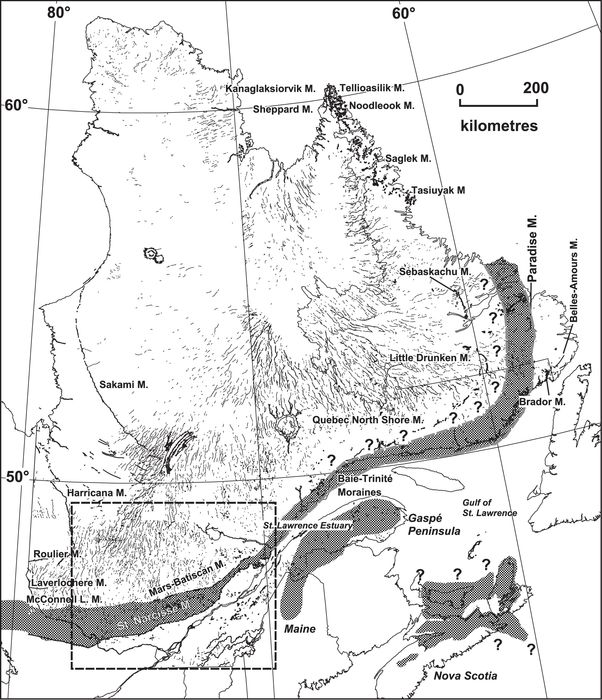
Moraines, eskers and tentative limits of Younger Dryas along the southeastern margin of the Laurentide Ice Sheet, in Québec and Labrador. The Saint-Narcisse morainic complex is related to the first part of Younger Dryas, and the Mars-Batiscan Moraine to the end. The North Shore Moraine is dated ca. 9500 BP (Dubois and Dionne, 1985). See Vincent (1989) and Veillette (1996) for the other moraines. Areas in gray on the southern side of the Gulf of St. Lawrence are related to Younger Dryas local glaciers, from Richard et al. (1997), Dorion et al. (2001) and Stea and Mott (2005).
Moraines, eskers et limites proposées du Dryas récent sur la marge sud-est de l’Inlandsis laurentidien, au Québec et au Labrador. Le complexe morainique de Saint-Narcisse et la Moraine Mars-Batiscan sont associés respectivement à la première partie et à la fin du Dryas récent. La Moraine de la Côte-Nord est datée vers 9500 BP (Dubois et Dionne, 1985). Voir Vincent (1989) et Veillette (1996) pour les autres moraines. Les surfaces en gris au sud du Golfe du Saint-Laurent correspondent aux glaciers locaux du Dryas récent, d’après Richard et al. (1997), Dorion et al. (2001) et Stea et Mott (2005).
Figure 2

Extent, lobes and re-entrants of the Saint-Narcisse morainic complex and other moraines in Québec. Mars-Batiscan Moraine outline from Govare (1995), Bolduc (1995), Robert (2001) and Simard et al. (2003). Ice front positions of the Outaouais Lobe from Barnett (1988) and this paper. See Occhietti et al. (2001) for moraines in southern Québec. Ice front outlines northwest of the Mars-Batiscan Moraine from Simard et al. (2003). Eskers from Occhietti et al. (2004).
Lobes et embaiements du complexe morainique de Saint-Narcisse et autres moraines du Québec. Tracé de la Moraine Mars-Batiscan d’après Govare (1995), Bolduc (1995), Robert (2001) et Simard et al. (2003). Limites du front glaciaire du lobe de l’Outaouais d’après Barnett (1988) et cet article. Voir Occhietti et al. (2001) pour les moraines du sud du Québec. Tracé du front glaciaire au nord-ouest de la Moraine Mars-Batiscan d’après Simard et al. (2003). Eskers de Occhietti et al. (2004).
Methodology
This study integrates data collected over the past 40 years from various outcrops along the Saint-Narcisse Moraine in the Saint-Maurice Valley and Simon Lake basin (Occhietti, 1980, 1989), Saguenay (Dionne and Occhietti, 1996), Charlevoix (Rondot, 1974; Govare, 1995; Occhietti, 2001), and Outaouais regions in Québec (Fig. 2), and in the Algonquin Provincial Park in Ontario (Daigneault and Occhietti, 2006). Facies were analyzed, using the terminology and criteria outlined in Dreimanis (1976) and Parent and Occhietti (1988). Depositional environments were then established by integrating outcrop sedimentology with landform morphology. Facies assemblages have been correlated allostratigraphically (Occhietti, 1990). Morphological assemblages (ice-marginal ridges and fluvioglacial forms) were identified from aerial photos and verified by field observation. A great bulk of data written in French which relate to the Saint-Narcisse Moraine (including many unpublished M.Sc. and Ph.D. thesis, journal publications, book sections, maps, etc.) are included.
The main question about the Saint-Narcisse Moraine is the age of the event. Datable material have been sampled from glaciomarine diamictons associated with morainic complexes, from marine silts in front or immediately on top of the moraine, from peat and gyttja close to the moraine, and from reworked deposits. The significance of 14C ages from marine shells in the Champlain-Goldthwait Seas has been thoroughly debated (Hillaire-Marcel, 1979, 1980, 1981; Rodrigues, 1992; Rodrigues and Vilks, 1994; Parent and Occhietti, 1999; Dyke et al., 2003; Occhietti and Richard, 2003; Richard and Occhietti, 2005). In this paper, mean-oceanic-reservoir corrected ages from marine shells will be used, with an estimated value of δ13C = 0‰ (reservoir correction of -410 years with regard to conventional ages) (Stuiver and Reimer, 1993; Table I). The local reservoir effect (ΔR) in Champlain Sea is variable. For example, in late Champlain Sea deposits (ca. 9500 BP) at the Saint-Nicolas site, 14C ages from littoral shells are at least 350 years older than 14C ages from wood (Occhietti et al., 2001a; Table II). This ΔR does not apply necessarily to all the basin, as demonstrated by two other cross-datings from samples of Mont Saint-Hilaire and its vicinity (Table II) where the additional local reservoir effect reaches 700 and 1170 years (Mott et al., 1981; Occhietti and Richard, 2003; Richard and Occhietti, 2005; Table III). During Younger Dryas, the oceanic reservoir effect was greater than at present, with apparent 14C normalized ages older by 700-800 years rather than 400 years (Bard et al., 1994). For this reason, indicative 14C ages from marine shells with YD ΔR = 700 yr and their equivalent in indicative calibrated ages (Calib 5.0.1 program, Reimer et al., 2004) will be tentatively used to estimate the age of the Saint-Narcisse Event. Ages from the western arm of Champlain Sea where carbonate bedrock and carbonate-rich tills caused anomalous 14C dates (Hillaire-Marcel, 1979; Occhietti, 1982; Fulton and Richard, 1987; Fulton et al., 1987; Rodrigues, 1988; Richard, 1990) are not taken into account. Ages with a lab error greater than 100 years will not be calibrated. A 14C BP vs calendar scale BP is established from the CalPal-2007 Hulu data set (Weninger and Jöris, 2008), using the program CalPal of Weninger et al. (2009), and compared to a calendar scale set with the Calib 5.0.1 program (Stuiver and Reimer, 1993; Fig. 3). The differences between the two data sets are most of the time lower than 100 years.
Table I
14C ages of marine shells and Foraminifera related to the Saint-Narcisse Event in Québec

* Apparently the same bottom bed was sampled, site Rivière-Sainte-Anne of LaSalle and Shilts (1993); GSC-2090, see also McNeely (1989).
N.B.: Ages with a standard deviation over 200 years are not listed.
Table II
Cross-dating of marine shells and wood or terrestrial fragments from the Champlain Sea basin
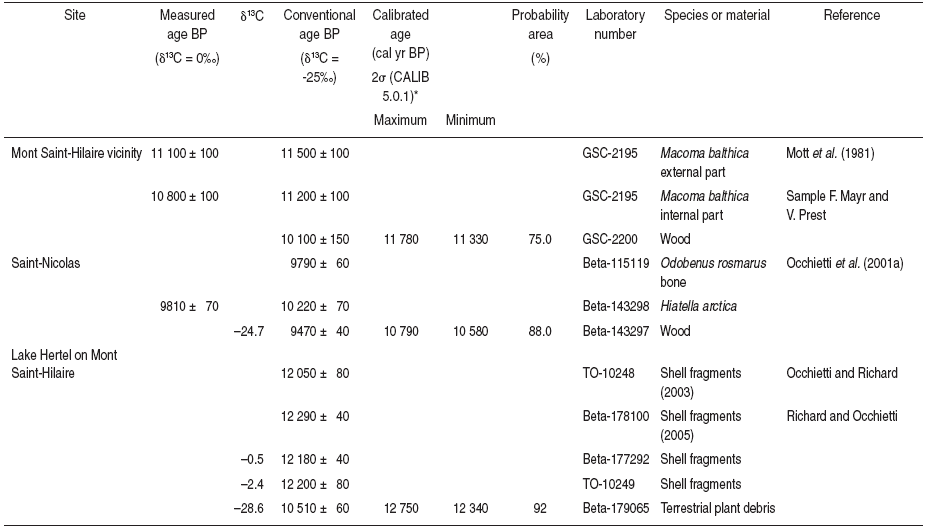
Stuiver and Reismer, 1993; Bard et al., 1993; Stuiver et al., 1998.
Table III
Conventional 14C ages (δ13C = -25 ‰) from bottom lake organic matter (excluding Lake à Saint-Germain and Lake aux Quenouilles terrestrial plant debris)

Figure 3
14C BP time scale vs calendar time scale BP. The calendar scale is established from the CalPal-2007 Hulu data set (Weninger and Jöris, 2008), using the program CalPal of Weninger et al. (2009) (thin lines) and the Calib 5.0.1 program (Stuiver and Reimer, 1993) (thick lines when Calib 5.0.1 ages are different from the Hulu scale). Stars related to the Saint-Narcisse Moraine are uncorrected 14C ages (δ13C = 0‰) from marine shells with unknown ΔR.
Comparaison des âges 14C BP aux âges étalonnés. Les traits fins correspondent à l’échelle calculée avec le programme CalPal de Weninger et al. (2009), à partir de la base de données CalPal-2007 (Weninger et Jöris, 2008). Les traits épais correspondent aux âges calculés avec le programme Calib 5.0.1 (Stuiver et Reimer, 1993) lorsqu’ils diffèrent de l’échelle Hulu. Les étoiles associées à la Moraine de Saint-Narcisse sont des âges 14C non corrigés (δ13C = 0‰) de coquilles marines avec un ΔR non connu.
The limits on ages from bottom lake and peat bog sediments are known. Mott and Farley-Gill (1981) calculated a 415 years hard water effect on gyttja from a lake south of the moraine, and Richard et al. (1997) in the Gaspé Peninsula, Anderson et al. (2001) in the Témiscamingue area and Occhietti and Richard (2003) at Mont Saint-Hilaire have confirmed that 14C ages from basal gyttja can be up to 2000 years older than the enclosed terrestrial organic debris. With AMS dating on small samples, the ages of terrestrial plant debris are now the reference ages which reflect directly the past atmospheric 14C content during the growth of the plants. These ages correspond to the first datable plant debris and are minimum ages for the local deglaciation. The time gap between local ice retreat and debris accumulation can be sometimes evaluated by extrapolation from the cumulative pollen concentration, in the sediments underlying the dated bed, divided by the pollen accumulation rate in the immediately overlying sediments (Richard and Occhietti, 2005). This gap reaches about 3.5 centuries on Mont Saint-Hilaire (Occhietti and Richard, 2003).
The calibration curve of 14C ages in calendar years shows plateaus and variations (Stuiver et al., 1998). The Younger Dryas period is characterised by a strong contraction of 14C ages as compared to calibrated or calendar ages (Fig. 3). On the contrary, the 11 200-10 900 14C yr BP critical period shows a dilatation of 14C ages. In order to evaluate the duration of the studied episodes, calendar years (expressed in cal ka) and mean rates of ice retreat calculated with calendar years will be also used in this paper.
Geology of the Saint-Narcisse Moraine: An overview
Facies
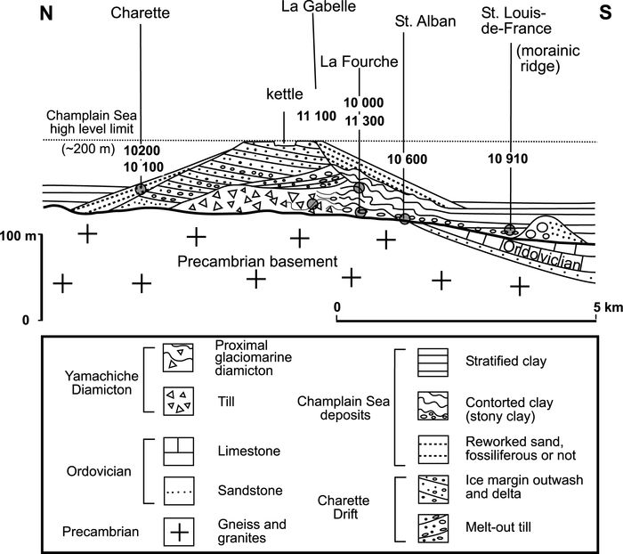
The Saint-Narcisse Moraine is a composite landform containing a variety of facies. Till and proglacial sediments are dominant in regions situated above the post-glacial marine limit (Lamothe, 1977; Pagé, 1977). In the Shawinigan area (Figs. 4 and 5), the ice front stayed in contact with the post-glacial Champlain Sea before, during and after the Saint-Narcisse Event. This region is characterized by a great variety of facies (Occhietti, 1980), including compact till with and without fissility, melt-out till with imbricated internal structure, ablation till, ice-contact deposits, fluvioglacial delta and fan deposits (Fig. 5). Part of the Saint-Narcisse Moraine has been reworked during post-glacial marine transgression, based on the presence of residual masses of blocks, resedimented sand beds with gentle dip and marine shells in living position, and a relatively coarse-grained cover which blankets the moraine (Karrow, 1959; Gadd and Karrow, 1959; Laverdière et Courtemanche, 1961; Denis and Prichonnet, 1973; Denis, 1974). Northward dipping sands on the proximal side of the moraine led Osborne (1951) to conclude that an ice tongue was present in the St. Lawrence Valley during late glacial time. However, these sands have been reinterpreted as northward-imbricated melt-out till slices and regressive beach deposits formed during post-glacial rebound and lowering of the level of Champlain Sea (Occhietti, 1980). Deformed silt beds (Fig. 5) were initially attributed to ice-push during the moraine accumulation (Occhietti, 1972); in many cases they are more likely proglacial marine silt with soft sedimentary gravity deformation.
Figure 4
Main ice margin features and 14C ages related to the Saint-Narcisse Event in the lower Saint-Maurice area (Trois-Rivières-Shawinigan area, Québec). Non conventional 14C ages (δ13C = 0‰): 10 710 BP from Rodrigues and Vilks (1994) and 11 000 BP from LaSalle and Shilts (1993), other ages from Occhietti (1980), Parent and Occhietti (1988) and this paper (Table I).
Principales formes de marge glaciaire et âges 14C liés à l’Épisode de Saint-Narcisse dans la région du bas Saint-Maurice (région de Trois-Rivières-Shawinigan, Québec). Ages 14C non conventionnels (δ13C = 0‰): 10 710 BP de Rodrigues et Vilks (1994), et 11 000 BP de LaSalle et Shilts (1993). Voir Occhietti (1980), Parent et Occhietti (1988) et cet article pour les autres âges (tableau I).
Figure 5
Stratigraphy of the Saint-Narcisse morainic complex at the edge of the Saint-Maurice lobe in Champlain Sea (sites located on Fig. 4).
Stratigraphie du complexe morainique de Saint-Narcisse à la marge du lobe du Saint-Maurice dans la mer de Champlain (les sites localisés sur la fig. 4).
A newly discovered section at Blanche River, close to Saint-Thuribe (Fig. 6), gives a good representation of the variety of facies deposited at the contact or in close proximity to the ice-marine water contact. The up-section succession of facies (distal proglacial silts and sands with minor dropstones, sand and gravel outwash, subglacial sandy diamicton) at this site indicates deposition during glacial readvance. Similar successions have been previously described in different regions along the moraine (Karrow, 1959; Gadd, 1971; Rodrigues and Vilks, 1994; Dionne and Occhietti, 1996).
Figure 6

Saint-Thuribe section of the Saint-Narcisse Moraine, located in the eastern part of the Shawinigan area (Fig. 4)
Coupe dans le bourrelet principal de la Moraine de Saint-Narcisse à Saint-Thuribe, située à l’est du secteur de Shawinigan (fig. 4).
Lithostratigraphy
Outcrop sections in the Saint-Narcisse Moraine are rare in the Laurentian Highlands. Here, the moraine is typically a ridge composed of ice-marginal deposits with large local proglacial fans. In regions under the post-glacial marine limit, the moraine is composed of diachronous units which reflect the sequence of events that generated it.
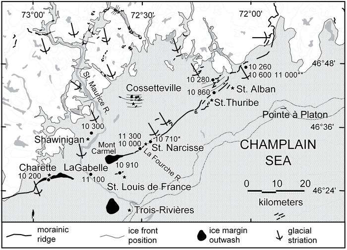
The most detailed stratigraphic succession is observed in the Shawinigan embayment of Champlain Sea (Occhietti, 1980; Fig. 4). Two groups of units can be traced from outcrop to outcrop for about 100 km. These are the Yamachiche Diamicton (Occhietti, 1980) and a younger ice-marginal facies assemblage we propose to name Charette Drift which was previously referred to as Saint-Narcisse Deposits (Occhietti, 1980; Fig. 5). The Yamachiche Diamicton is composed of massive proximal glaciomarine deposits, deformed stratified stony silt and sand, and muddy subglacial till. These facies form the core of the moraine in the valley of the Saint-Maurice River and other rivers in the region. The Charette Drift includes sandy till, melt-out till and various types of ice-contact and fluvioglacial deposits which form the morainic relief. Previously, all these distinct deposits (Yamachiche Diamicton and Charette Drift) were grouped with other tills under the title of Gentilly Till (Gadd, 1971). If the small ridges north of the Saint-Narcisse Moraine are taken to represent progressive ice retreat, the Charette Drift would be a morphostratigraphic unit which is part of the group of tills in the Laurentide region, and the Yamachiche Diamicton is a transitional unit between marine and glacial deposits. The Saint-Thuribe section described above (Fig. 6) shows that three fluctuations (each of them including a short retreat, a floating ice margin, and an ice-anchored readvance) preceded the main readvance. The main episode is represented by submarine outwash deposits overlain by a typical sandy till which changes laterally to a melt-out till. The melt-out till indicates that the phase which ultimately built the moraine is related to compressive melting ice.
Denis (1974) drilled several boreholes into the Saint-Narcisse Moraine in the Lake Maskinongé area, 70 km west of Shawinigan. He observed a facies change from upper marine sediments to basal lodgment till. The Charette till or ice-contact deposits locally overlie these marine sediments.
In the region of the Saguenay River mouth, a muddy diamicton intercalated in prodeltaic marine muds indicates that ice readvanced into marine waters. At Tadoussac, the large hanging delta, with a kettled deltaic plain and surficial channels toward the estuary, is attributed to the final phase of the Saint-Narcisse episode. The analysis of the stratigraphic context (Dionne and Occhietti, 1996) revealed that the perched delta was preserved because it rests directly on elevated bedrock. In contrast, in the Saguenay fjord and in the lateral valley of the Moulin à Baude River, the delta collapsed after the underlying stagnant ice melted out.
Evidence for an ice readvance during the Saint-Narcisse Event
Based on contorted marine sediments underlying till in the Shawinigan embayment, Karrow (1959) and Gadd and Karrow (1959) concluded that “the ice margin advanced from the highlands into the marine basin to form the Saint-Narcisse Moraine”. They estimated a 8 to 10 km readvance of the ice margin. Compressive push structures and the relatively thick Yamachiche Diamicton (up to 30 m), compared to the usual thickness of tills in the area (a few metres), is suggestive of a readvance. However, there is no way at present time to properly estimate the dimensions of the readvance in the Shawinigan embayment. In Charlevoix, north of the middle St. Lawrence Estuary, a lobe advanced by at least 17 km south of the general outline of the Saint-Narcisse Moraine (Rondot, 1974; Fig. 7), and some local lobes readvanced in valleys, for example in the Saguenay mouth, the Gatineau Valley, and probably in the Ottawa Valley. Such readvances are local and limited. There is no direct evidence of a readvance in the interlobe areas.
Figure 7

Ice front positions related to the Saint-Narcisse morainic complex and older moraines in Charlevoix, Québec, from Rondot (1974), Govare (1995) and Occhietti (2001).
Positions du front glaciaire associées au complexe morainique de Saint-Narcisse et aux moraines plus anciennes de Charlevoix, Québec, d’après Rondot (1974), Govare (1995) et Occhietti (2001).
Lateral extent
Originally, the name of the moraine was given by Osborne (1951) to a morainic segment in the Trois-Rivières area. Subsequently, the Saint-Narcisse Moraine was proposed to extend approximately 500 km, from Simon Lake in the west to Saint-Siméon in the east (LaSalle and Elson, 1975). This extension was partly based on several local studies (see Fig. 2 for regional names). It included the studies of Parry (1963), Parry and MacPherson (1964), and Laverdière and Courtemanche (1961) in the Laurentians northwest to northeast of Montréal. It included also the work of Dufour (1969) west of Québec City, Dionne et al. (1968) and LaSalle et al. (1972) in the Parc des Laurentides region (north of Québec City), Hardy (1970), LaSalle et al. (1972) and Rondot (1974) in the Charlevoix area (Fig. 7), Osborne (1951), Lunde (1953), Karrow (1959), Gadd and Karrow (1959) and Gadd (1971) in the Trois-Rivières area, and Denis (1974) in the Lake Maskinongé area.
Subsequent work has extended the moraine to the west and to the east. The moraine has been extended eastward into the Saguenay region (Govare, 1995; Dionne and Occhietti, 1996; Fig. 2). Westward from Simon Lake, a thin ridge extends 40 km to the Val-des-Bois fluvioglacial complex (Occhietti, 1980; Site 7 on Fig. 8). For this paper, the area westward from Val-des-Bois to the Ottawa River was studied in order to close the gap of information between the western known-limit of the Saint-Narcisse Moraine and the Ottawa River Valley (about 70 km) (Gadd, 1987). Field work (see below in Outaouais lobe and Gatineau segment) confirmed the east-west outline of the recessional ice front related to the Saint-Narcisse Event up to the Grand Calumet Island in the Ottawa River Valley (Fig. 8). There, the moraine is associated with the intermediate ice-marginal lobated features C described by Barnett (1988). Ice-marginal features B, about 12 km to the south of features C, were followed by Barnett (1988) for 35 km westward to Mink Lake. West of Mink Lake, the multi-ridged group B is followed westward for 35 additional kilometres. To the west-northwest, these marginal features are in alignment with large ice front features on the Algonquin Highlands mapped by Chapman and Putnam (1984) and with several minor features mapped by Ford and Bajc (1984) and Ford and Geddes (1986). Daigneault and Occhietti (2006) mapped the major and minor moraines in the Algonquin Provincial Park area, between Mink Lake and the western ice-marginal features. They correlate the Algonquin III-Outaouais BC morainic alignment, 235 km long, to the Saint-Narcisse Moraine.
Figure 8
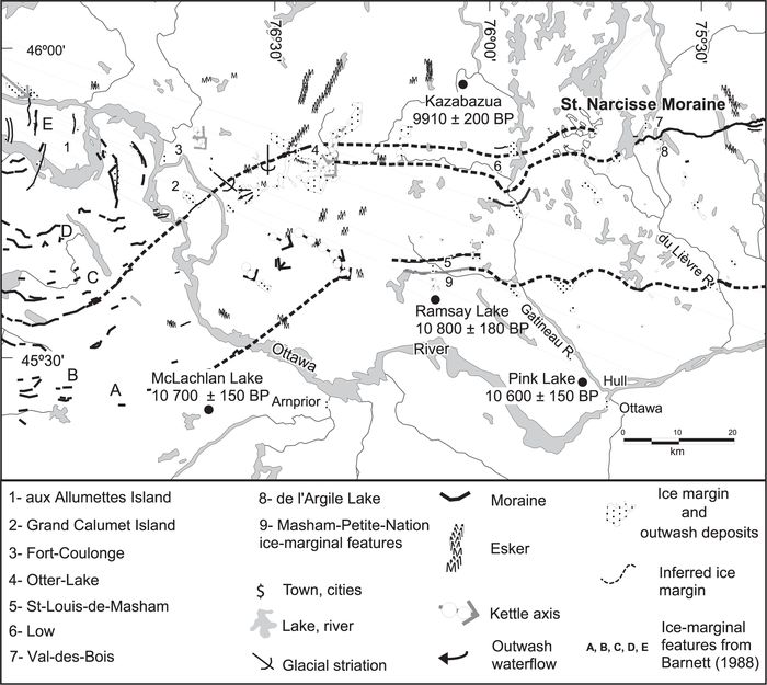
Western extent of the Saint-Narcisse morainic complex and ice margin features in the Gatineau River area (Québec) (Robert, 2001; this paper), and relation with the arcuate ice margin features of Barnett (1988) in the Ottawa River Valley (Ontario and Québec).
Prolongement à l’ouest du complexe morainique de Saint-Narcisse et témoins de la marge glaciaire dans la région de la rivière Gatineau (Québec) (Robert, 2001; cet article) et corrélation avec les formes arquées de la marge glaciaire de Barnett (1988) dans la vallée de l’Outaouais (Ontario et Québec).
From these new data and correlation, the Saint-Narcisse morainic complex can now be traced in Québec for 750 km from the Saguenay Fjord to the Ottawa River. Correlative ice front features are followed discontinuously for 235 additional kilometres in Ontario (Fig. 9).
Figure 9

Younger Dryas moraines and other moraines along the southeastern margin of the Laurentide Ice Sheet, from Lake Superior to the Saguenay Fjord. The Saint-Narcisse morainic complex and Whiskey Lake Moraine (Boissonneau, 1968) are related to an early phase of Younger Dryas. The Mars-Batiscan, Cartier I (Boissonneau, 1968) and Grand Marais I Moraines (Lowell et al.,1999) are related to the end of Younger Dryas. Moraines in Ontario, from Harrison (1972), Vincent (1989), Veillette (1994, 1996), Lewis et al. (2005) and Daigneault and Occhietti (2006).
Moraines du Dryas récent et autres moraines le long de la marge sud-est de l’Inlandsis laurentidien, du lac Supérieur au fjord du Saguenay. Le complexe morainique de Saint-Narcisse et la moraine du lac Whiskey (Boissonneau, 1968) sont associés à une phase ancienne du Dryas récent. Les moraines de Mars-Batiscan, de Cartier I et de Grand Marais I sont attribuées à la phase finale du Dryas récent. Moraines de l’Ontario d’après Harrison (1972), Vincent (1989), Veillette (1994, 1996), Lewis et al. (2005) et Daigneault et Occhietti (2006).
General morphological outline of the Saint-Narcisse Moraine
The Saint-Narcisse Moraine is a non-homogeneous major ice front feature. Study of local segments reveals a very diverse and partly diachronic ice-marginal complex. The moraine is made up of discontinuous ice-frontal constructions to the west and of a continuous ridge or ridge assemblage to the east. In areas where there are many concentric ridges, such as in Charlevoix and the Ottawa River Valley, the position of the morainic ridge which would be strictly correlative to the main episode of the Saint-Narcisse Event is ambiguous. In these areas, the Saint-Narcisse Moraine is best described as the Saint-Narcisse morainic complex.
The Saint-Narcisse Moraine outline consists of southward-facing lobate protrusions and northward-facing reentrants which give a general lobate outline to the moraine (Occhietti, 1980; Govare, 1995; Fig. 2). At least 30% of the ice front was directly in contact with the post-glacial Champlain and Goldthwait Seas. The morainic complex can be subdivided into segments as follows, from west to east (Fig. 2): (1) the Algonquin Highlands segment, (2) the Outaouais (Ottawa River Valley) lobe, (3) the Gatineau lobe, a roughly rectilinear segment between Ottawa River and Simon Lake, (4) the Mont Tremblant reentrant, at 15 km north of the general outline, (5) the Saint-Maurice lobe, (6) the Parc des Laurentides reentrant, at 30 km north of the general outline, (7) the Charlevoix lobe, and (8) the Saguenay lobe. The reentrants coincide with topographic highs (Mont Tremblant, Parc des Laurentides) and the lobes occur in relative low lying regions (Ottawa River Valley, Shawinigan Embayment, Charlevoix Astrobleme and Saguenay Fjord). Some of these segments are described below.
Segments of the Saint-Narcisse morainic complex
The reentrants and roughly rectilinear sections of the Saint-Narcisse Moraine are mostly represented by simple morainic ridges with ice-contact and proglacial forms. In the lobes (Saguenay lobe excepted), the Saint-Narcisse morainic complex is composed of concentric ice-marginal features that may extend as much as 65 km from the outer to the inner ridges. As they were in contact with post-glacial marine waters, lobes bear the best sedimentological and stratigraphic evidence of the origin of the Saint-Narcisse complex. There is no evidence that the outer limits of these lobes were built at the same time as the reentrant ridges. For this reason, all the ice-marginal features related to the Saint-Narcisse Event are taken into account here, not just the outer limit of these features.
Outaouais lobe
In the Ottawa River Valley, over a distance of 65 km on the Ontario side (Figs. 8 and 9), Barnett (1988) mapped 13 discontinuous concentric ice-marginal features from Renfrew to Petawawa, placed them into groups (A to E), and described five main recessional episodes. He noted a drop of relative sea-level during recessional phases related to B and C groups. Outer ice front features (group A and outer features of B) record a higher relative sea-level and correspond to earlier glacial phases. As mentioned by Barnett (1988), the two tills described by Catto et al. (1981) in the Chalk River area, 75 km upstream from group A, may represent a minor ice-front fluctuation. This fluctuation is younger than the Saint-Narcisse main ridge deposition and may be related to a late inner ridge.
New data on the left side of the Ottawa River and on the Grand Calumet Island, in Québec, indicate a complex ice retreat. In the lowlands, several sets of aligned kettles, 1- to 4-km long, are mostly oriented northwest-southeast (Fig. 8). They are related to concealed fluvioglacial axes (eskers?) which covered dead ice. Bedrock striations record also a late southeast ice flow, as already observed by Gadd (1980, 1987). From these features and the arcuate ridges on the right side, an ice lobe is inferred in the Ottawa River Valley, the Outaouais lobe. It corresponds to a late ice stream in the valley toward the southeast, associated or not to an early limited readvance. Late-glacial and post-glacial fluvial erosion erased most of the ice retreat features in the Ottawa River Valley, preventing the direct connection between the ice-marginal features on both sides of the valley.
Locally (Fig. 8), outwash fans with kettles were built by meltwaters flowing from the north over dead ice. They are related to melting stagnant ice on the Laurentian reliefs with a south to north ice front retreat. This ice retreat mode can be applied when the Ottawa River flows west to east. In the lowlands related to the north to south part of the Ottawa Valley, the ice retreat mode is related to the Outaouais lobe, as indicated by small ridges oriented north-south.
In the central part of the Grand Calumet Island, a ridge of ice-contact stratified drift is correlated with the Saint-Narcisse Moraine and the ice-marginal features of group C (Fig. 8).
Gatineau lobe: new data
The western Gatineau lobe (Fig. 8) indicates a style of ice margin retreat of the LIS which is distinct from the eastern segments. This description is based on new data, with some local glaciofluvial deposits mapped by Richard (1974, 1975, 1980). Ice-marginal features are discontinuous and appear mostly across the large structural valleys of the area as ice-contact ridges, ice-marginal deltas or heads of valley trains. The ice-marginal positions are often concealed by outwash valley trains, marine clay or delta deposits (Fig. 8). In the Gatineau Valley, a transverse ridge is observed 7 km south of the regional outline of the Saint-Narcisse Moraine, and marine clay is locally covered by outwash deposits at 3.5 km south of this position. An ice lobe readvanced or was standing in this valley during probably an early phase of the Saint-Narcisse Event. West of the Gatineau Valley, 2-km-wide valleys are filled up with coarse outwash, and discontinuous transverse ice-marginal features are distributed over 8 to 18 km from south to north. Southwest of Otter Lake (Fig. 8), an ice margin is indicated by a pitted moraine and an outwash fan, with kettles and surficial channels. Stagnant ice in the valleys at the southern edge of the Laurentians is inferred from these features. On the whole, in the Gatineau area, it seems that meltwater outwash was the local main process of deposition at the margin of the LIS. The extension of the Saint-Narcisse Moraine is located within an envelope of ice-marginal and stagnant ice features (Fig. 8) which remain parallel to a west-east outline.
Saint-Maurice lobe and associated ice-marginal ridges
In the eastern part of the Saint-Maurice River topographic embayment (the Shawinigan embayment), Karrow (1959) mapped ridges north of the Saint-Narcisse Moraine (Fig. 4). At Cossetteville, nineteen ridges emerge locally through the marine mud-plain (Béland, 1961; Occhietti, 1977, 1980). The Saint-Maurice lobe represents a local readvance of the ice front in the St. Lawrence Valley. During construction of the Saint-Narcisse Moraine, the glacial margin lay along the topographic margin between the Canadian Shield and the St. Lawrence Sedimentary Platform (Fig. 5).
Charlevoix lobe and associated ice-marginal ridges
Glacial ridges have been identified by Mawdsley (1927) and Miller (1951, 1973) in the Parc des Laurentides highlands (Fig. 7). A 10- to 20-m high ridge is often accompanied by smaller ridges to the north of it. Locally, a 1-km zone with ubiquitous forms indicative of ice stagnation is present north of the main ridge (Govare, 1995). In central Charlevoix, structural depressions of the Charlevoix astrobleme (Rondot, 2000) favored ice convergence and flow which terminated in the marine waters of Goldthwait Sea to the south (Rondot, 1974; Poulin, 1976; Govare, 1995; Fig. 7). The ice lobe readvanced by at least 17 km to the south, over a deglaciated area characterized by west to east glacial striations and dispersion trains of anorthosite debris. The ice-marginal complex can be subdivided into a continuous arcuate outer moraine, 26 minor ridges, another concentric intermediate major moraine and seven inner minor moraines (Rondot, 1969, 1974). Depending on the periodicity of the ridge deposition (1 year?, 5 years?, 11 years?), the stabilization-slow retreat phase of the Saint-Narcisse Event could have lasted from 35 to 350 years. The outer ridge represents the maximum ice front position of the Saint-Narcisse Event, and northerly ridges record phases of stabilization of the ice front. LaSalle (1970) usually connected the intermediate major morainic ridge with the general outline of the Saint-Narcisse Moraine.
Towards Saint-Siméon, on the eastern side of the Charlevoix lobe, the moraine is often present as a main distal ridge with secondary proximal ridges (Miller 1951, 1973; Rondot, 1969; Hardy, 1970). East of Saint-Siméon, a single morainic ridge follows a bedrock high which contours the St. Lawrence Estuary (Miller, 1951; Govare, 1995). An ice contact accumulation of boulders form a small island (Chaffaud aux Basques Island; Dionne, 1996).
Associated glacial forms of the Saguenay lobe
Based on bedrock glacial striations between Saint-Siméon and Tadoussac, it is clear that a mass of ice functioned almost independantly in the Saguenay fjord (Fig. 2). A diamicton bed intercalated in prodeltaic marine muds west of the Saguenay River mouth, and a perched delta with kettled alluvial plain at Tadoussac, indicate a readvance of the glacier at the mouth of the Saguenay River (Dionne and Occhietti, 1996; see Stop 2.1 in Bhiry et al., 2001). Three concentric subaqueous ridges identified from bathymetric charts of the mouth of the Saguenay were originally interpreted as having a glacial origin (Dionne and Occhietti, 1996), but, following seismic surveys, have since been reinterpreted as scoured channels in a large prodeltaic system. East of the mouth of the Saguenay River, the ice front related to the Saint-Narcisse Moraine is apparently located offshore in the present estuary.
Ice-marginal features south of the Saint-Narcisse Moraine
Between the northernmost moraines in the Appalachians of southern Québec (LaSalle et al., 1977a, 1977b; Parent and Occhietti, 1999) and the outer limit of the Saint-Narcisse morainic complex, ice-marginal features are rarely observed and not continuous. This is related to a rapid ice retreat with phases of calving ice in Champlain Sea.
South of the Shawinigan embayment, local ice-marginal features were identified south of Charette and at the Trois-Rivières airport (Gadd and Karrow, 1959; Occhietti, 1980; Fig. 4). At Saint-Louis-de-France (Fig. 4), a small morainic ridge was observed in a quarry. The ridge is older than 10 910 BP ± 160 (I-9484, indicative age of 10 610 BP) from shells in a marine unit overlying a bed with sandstone dropstones on the inner side of the ridge. The sandstone debris (Ordovician Black River Group) indicate glacial erosion of sandstone outcrops located 8 km to the north (Occhietti, 1980; Parent and Occhietti, 1988; Fig. 5).
North of Québec City, LaSalle et al. (1972) observed an ice-marginal complex at Lake Saint-Charles. Southwest of Québec City, three sites expose a massive diamicton with and without Balanushameri fragments overlying stratified sand and gravel. The diamicton, named Saint-Nicolas Till, is attributed to a glacial readvance during Younger Dryas time (LaSalle and Shilts, 1993). Cummings (2000) interpreted the matrix-supported diamicton as a sub-glacial till. The limited extent of the till, the age of shells in living position below the till (10 900 ± 160 BP, GSC-5957), the various origins of other dated beds with Balanushameri (the Rivière du Chêne dated bed at 11 300 ± 100 BP, GSC-5927 is not overlain by a diamicton), and the distance between the sites and the Saint-Narcisse Moraine to the north (50 km and more), suggest that the till is related to a short ice surge in Champlain Sea. The ice surge probably originated from the area where the outline of the Saint-Narcisse Moraine changes direction abruptly (upper right side on Fig. 4), on the southwest margin of the Parc des Laurentides highlands. The Saint-Nicolas Event seems to have happened during the early stabilization phase of the Saint-Narcisse Event, when the Yamachiche Diamicton was deposited. It would correspond to a very early phase of YD, but its climatic significance is not demonstrated and its extent is more limited than sketched by LaSalle and Shilts (1993).
Near Saint-Édouard, south of the St. Lawrence River, a 1-km-long ridge was discovered by LaSalle (LaSalle and Shilts, 1993). From a recent survey, the moraine is composed of melt-out till with imbricated structures. Based on the lack of evidence of a local readvance on the sections of the Rivière du Chêne in the vicinity, and the difference between the melt-out till and the Saint-Nicolas Till, Cummings (2000) concluded that this moraine is not related to the Saint-Nicolas Event. A new small moraine on the southern bank of the St. Lawrence (Pointe au Platon, 34 km east of St. Thuribe, Fig. 4) could be related to the Saint-Nicolas Event.
In Charlevoix, the Saint-Narcisse Moraine is completely distinct from earlier ice-marginal features (Fig. 7), such as the Rochette Moraine, at 15 km from the outer ridges of the Saint-Narcisse complex and 30 km from the general outline of the Saint-Narcisse Moraine (Rondot, 1974; Govare, 1995), and the Brulée Moraine about 45 km from the general outline (Fournier, 1998; Occhietti, 2001).
During the survey in the Gatineau area, ice-marginal features were observed in the Saint-Louis-de-Masham area (Fig. 8), at 15 km south of the general outline of the Saint-Narcisse Moraine. They form two parallel features, the main one was named Masham Moraine I (Daigneault and Occhietti, 2006). These features can be aligned with other minor ice front features observed further east by Allard (1977) in the Rivière du Lièvre Valley (Fig. 8) and with the ridges A and outer B in the Ottawa River Valley further west. From a field survey conducted for this paper east of the Rivière du Lièvre Valley, along the margin of the Laurentians on the north side of the Ottawa River, the discontinuous alignment of ice marginal features can be followed for 35 km as far as Portage-de-la-Nation, in the Petite-Nation Reservation. The name of Masham—Petite-Nation ice-marginal alignment is proposed for these features observed over 110 km (Fig. 9).
From these discontinuous features, it can be concluded that the ice front stabilized shortly before the earliest phase of the Saint-Narcisse Event. The most prominent alignment of ice front features is located about 15-30 km from the general outline related to the Saint-Narcisse Moraine. A time span of about 100 to 200 years can be inferred from the distance, if ice retreat rates between 250 and 100 m/yr are applied. Some of these discontinuous ice-marginal features could be related to a short but intense cold event that was documented by Levesque et al. (1993) in Eastern Canada, the Killarney Oscillation.
Moraines north of the Saint-Narcisse morainic complex in Québec
In Québec, the next prominent moraine north of the inner ridges of the Saint-Narcisse morainic complex is the Mars-Batiscan Moraine. The Mars-Batiscan Moraine has been observed in the Charlevoix region (Govare, 1995), in the Parc des Laurentides Highlands (Bolduc, 1995), and recently in the middle reaches of the Saint-Maurice Valley (Robert, 2001; Simard et al., 2003), at a distance of 17 km from the Saint-Narcisse Moraine in the eastern part and 70 km from the lower Saint-Maurice area (Fig. 2). Between the Saint-Narcisse and Mars-Batiscan Moraines, local moraines and ice-marginal features have been mapped (Occhietti, 1980; Gagnon and Morelli, 1986; Occhietti et al., 2004; Figs. 2 and 4). These local ridges indicate a slow ice-retreat rate of about 100 m/year (Occhietti, 1980). Based on this rate and available 14C ages, Robert (2001) has estimated that the age of the Mars-Batiscan Moraine is between 9940 and 10 000 BP. On the Laurentian plateau, the ice front margin north of the Mars-Batiscan Moraine is roughly linear, with minor lobations (Simard et al., 2003; Figs. 1 and 2). The general outline is oriented east northeast-west south west, and reaches the Ottawa River close to the McConnell Lake Moraine.
Tentative correlation of the Saint-Narcisse Moraine complex to the east, on the north shore of the St. Lawrence Estuary and Gulf, and in southeastern Labrador
According to Dredge (1983) and Vincent (1989), the short outer moraine of Baie-Trinité, 300 km downstream the Saguenay River, is correlated to the Saint-Narcisse Moraine (Fig. 1). The ice front on each side of this moraine was located in the St. Lawrence Estuary and Gulf. The inner moraine of Baie-Trinité belongs to the 800-km-long Québec North Shore Moraine (Dubois and Dionne, 1985) that is correlated to the Little Drunken and Sebaskachu Moraines in Labrador (Fulton, 1986a, 1986b; Dyke and Prest, 1987, 1989; Occhietti et al., 2004; Fig. 1). From this correlation, the equivalent of the Saint-Narcisse Moraine in southeastern Labrador would be the Paradise Moraine (Fig. 1). Southwest of the Québec North Shore Moraine, field data are lacking, but a post-Saint-Narcisse ice lobe in the Saguenay Valley is inferred by Dionne and Occhietti (1996).
Synthesis
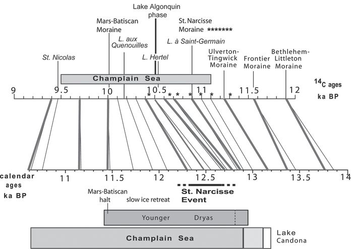
In the Saint-Maurice lower Valley, the Saint-Narcisse Moraine is a complex formed by stacked ice front features. It comprises either a major composite ridge, or a main outer ridge and inner secondary ridges (Figs. 4 and 5). Laterally, along the southern edge of the Laurentians and in the Algonquin Highlands, this morainic complex comprises one or two main ridges or locally groups of concentric ice-marginal features (Fig. 9). In previous papers, out of the lower Saint-Maurice Valley, the name of Saint-Narcisse Moraine was specifically applied to the almost continuous ridge or pair of ridges which can be followed from the Ottawa River Valley to the Saguenay River (Occhietti, 2001). It is suggested to maintain this name, even if the exact position of this moraine in the Charlevoix group of morainic ridges is not perfectly established. The Saint-Narcisse Moraine was deposited during the main phase of the sequence of events reconstructed along the past ice margin, but does not represent the complete set of events. We propose to name Saint-Narcisse morainic complex the whole set of ice-marginal features deposited on the southern edge of the Laurentians and on the Algonquin Highlands, during the sequence of events recorded in the lower Saint-Maurice Valley. This group includes various local groups of ice-marginal features, from the glaciomarine deposits or outermost morainic ridges related to the early stabilization or readvance phase, to the innermost ridges of the very-slow ice-retreat late phase (Table IV). The outer limit of this morphostratigraphic group is clearly visible in most of the segments of the past ice front, except for the Ottawa middle Valley. There, the outer limit corresponds tentatively to the median ridges B. The inner limit of the Saint-Narcisse morainic complex is assigned to the innermost ridge of the concentric ice-marginal features. Again in the eroded Ottawa River Valley, this inner limit is tentatively related to ridges D or may be E. The Saint-Narcisse morainic complex is related to the early Younger Dryas period of time-early Algonquin Stadial, as stated below.
Table IV
Phases of the Saint-Narcisse Event and Younger Dryas in southern Québec
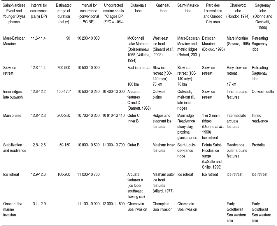
Probably over 200 years in the Charlevoix lobe.
Age of the Saint-Narcisse Event
LaSalle and Elson (1975) suggested that “the time of emplacement” of the Saint-Narcisse moraine “was roughly 11 000 years ago, well after the beginning of the Champlain Sea Episode”. From a statistical analysis of 14C ages, Hillaire-Marcel and Occhietti (1977) noted that the Saint-Narcisse Moraine corresponded with the cooling at the beginning of Dryas III. Other papers dated the event within a range comprised between 11 000 and 10 300 BP, with few direct evidence.
Age of the early phases of the Saint-Narcisse Event
Indicative ages of the early and main phases of the Saint-Narcisse Event from marine shells
There are only two 14C ages (δ13C = 0‰, Table I) from fossils sampled below the Saint-Narcisse glacial deposits, both from the Shawinigan region (Fig. 4): 10 710 ± 40 BP (TO-819) from Rivière des Chutes close to Saint-Narcisse (foraminifers, Rodrigues and Vilks, 1994) and 10 860 ± 40 BP (Beta-143300) from Saint-Thuribe (Portlandiaarctica) (Fig. 6). Reworked shells in the Yamachiche Diamicton from the same region are dated at 11 100 ± 90 and 11 300 ± 160 BP (Table I) and the large glaciomarine prodelta of Tadoussac, at the mouth of the Saguenay River, was built ca. 11 100-11 000 BP. As the total ΔR is not known, these uncorrected ages (stars on Fig. 10) give only indicative ages between 11 000 and 10 410 BP if the total estimated YR ΔR = 700 yr is applied to the conventional ages. Indicative calibrated ages would be comprised between about 12.9 and 12.37 cal ka.
Figure 10

Tentative chronology of the Saint-Narcisse Event in Québec. Two landmarks constrain the time span of the Saint-Narcisse main phase. The Saint-Narcisse Moraine is deposited after the Champlain Sea onset and a rapid ice retreat, and before the drainage of glacial Lake Algonquin through an early outlet towards the Ottawa River Valley (probably the Fossmill Outlet) (see Barnett (1988), and Daigneault and Occhietti (2006)). According to Lewis et al. (2005), the drawdown of Lake Algonquin began ca. 10 500 BP (12.46-12.59 cal ka). Some later ridges across the Ottawa Valley may correspond to the inner ridges of the Shawinigan and Charlevoix areas.
Hypothèse de chronologie de l’Épisode de Saint-Narcisse au Québec. Deux repères limitent l’éventail d’âges de la phase principale. La Moraine de Saint-Narcisse est déposée après l’invasion de la Mer de Champlain et une déglaciation rapide. Elle précède le début du déversement du Lac glaciaire Algonquin par un exutoire précoce, probablement celui de Fossmill, vers la vallée de l’Outaouais (voir Barnett (1988) et Daigneault et Occhietti (2006)). Ce déversement commence vers 10 500 BP (12.46-12.59 ka cal ) d’après Lewis et al. (2005). Des bourrelets plus récents transversaux à la vallée de l’Outaouais correspondent probablement aux bourrelets internes du complexe morainique dans les secteurs de Shawinigan et du Charlevoix.
Estimated age of pre-Saint-Narcisse vegetation from bulk organic matter and terrestrial plant debris
One 14C age, from terrestrial plant debris extracted at the bottom of lacustrine deposits, is presently available from a site (Lake à Saint-Germain; Occhietti and Richard, 2003) at a close location south of the moraine: 10 900 ± 40 BP (Beta-180797; 12.9 to 12.8 cal ka). A negligible time gap between local deglaciation and plant debris sedimentation is inferred. Located 5 km south of the moraine, the site would have been free of ice about 20-25 years before deglaciation at the Saint-Narcisse emplacement, with an ice retreat rate of 250 m/y. The age of the ice front related to the Saint-Narcisse Moraine can be younger if a more extensive ice retreat to the north preceded a possible readvance. With the time gap, 12.8 cal ka is presently the apparent maximum age of the beginning of the Saint-Narcisse Event in this area located 80 km north of Montréal. Other basal ages from the southern edge of the Laurentians (Table III) are comprised between 10 900 and 10 700 BP (Anderson, 1988). All these other values could differ from the real age because of two opposed factors: the hard water effect and the time gap between local ice retreat and the age of the lowest dated plant debris.
Estimated age of the beginning of the Saint-Narcisse Event by comparison with other events in southern Québec and by using ice retreat rates
The opening of the central St. Lawrence Valley to Champlain Sea waters is dated ca. 11 100 ± 100 BP (ca. 13.1-12.89 cal ka), age based on new 14C dates from Mont Saint-Hilaire, associated with pollen correlation and extrapolation from the cumulative pollen concentration (Richard and Occhietti, 2005). This is in concordance with the age proposed by Anderson (1988) in the Boyd Pond sediments, in New York State, later than 11 200 ± 190 BP. Nevertheless, younger ages were obtained in the Lake Champlain basin and the onset time would be comprised between 13.1 and 12.7 cal ka (Cronin et al., 2008). If the same mean ice-retreat rate of 250 m/yr as in the Appalachians is applied (Parent and Occhietti, 1999), deglaciation of the central St. Lawrence Valley, from the Appalachian piedmont to the position of the Saint-Narcisse Moraine in the Saint-Maurice Valley, would have lasted about 260 calendar years for 65 km. The early YD ice-retreat slowdown would have been compensated by a calving ablation. With this approach, the Saint-Narcisse ice front stabilization would have occurred ca. 12.8-12.7 cal ka (about 10 800-10 600 BP), or later in the case of an important ice retreat and re-advance. From these data, 12.7 ± 0.1 cal ka would be the acceptable age of the beginning of the Saint-Narcisse Event. A minimum delay of one to two centuries between the atmospheric change recorded in the Greenland ice cores and the LIS full response is inferred.
Estimated age of the end of the Saint-Narcisse Event
Indicative age of the late phase of the Saint-Narcisse Event from marine shells
The age of the end of the Saint-Narcisse Event from marine shells is controversial. Uncorrected ages (δ13C = 0‰; Table I) of post-Saint-Narcisse sediments from marine shells are surprisingly young. In the Shawinigan embayment, north of Saint-Thuribe (Fig. 4), Hiatellaarctica shells in living position on the distal side of one of the inner ridges give an age of 10 280 ± 90 BP (Beta-14299). Ages are older in Charlevoix (10 640 ± 130 BP, GSC-2090; Govare, 1995) from the inner side of one of the ridges, and in the Saguenay lobe area (10 400 BP, I-5922). These dates are related to basal marine sediments (the Saguenay shells excepted) over glacial deposits and give minimum ages of the ice retreat. If a YD ΔR = 700 yr was applied, the tentative minimum ages would be comprised between 10 340 and 9980 BP, partly in Holocene, and contradict other data (see below). At that time, the middle Ottawa Valley and the Lake Saint-Jean basin were ice free. A delay of several centuries between local ice retreat and marine shell colonization could explain these young ages, but such a delay is not expectable with marine shells, except in the case of strong erosional bottom currents. The total ΔR could be lower than 700 years, but the additional ΔR value for similar 14C ages on marine shells from Saint-Nicolas is 350 years (total ΔR = 760 yr). Furthermore, the basal age on the ridge north of Saint-Thuribe, 10 280 ± 90 BP, is similar to the age of late Champlain Sea Myaarenaria shells from Shawinigan (10 300 ± 100 BP, GSC-2101), whereas the two shell associations are not compatible. The problem is not solved and ages from post-Saint-Narcisse marine shells cannot be used.
Minimum age of post-Saint-Narcisse vegetation from bulk organic matter and terrestrial plant debris
Ages from organic matter, closely north of the moraine, range usually between 9910 and 9540 BP, with the exception of the age of 10 820 ± 160 BP (I-10094) from the site referred to as SAV2, Sainte-Agathe, by Savoie (1978) and Savoie and Richard (1979), and as Lake aux Quenouilles in this paper, which seemed too old (hard water effect). The bottom lake sediments of this site have been resampled and the lowermost terrestrial plant debris give a standard age of 10 180 ± 40 BP (Beta-244077; Richard, personal communication; Table III) which corresponds to 11.98-11.81 cal ka BP (relative area 95%, 1σ standard deviation). As mentioned in Methodology, a delay of several centuries between local ice retreat and first datable evidence of vegetation is expectable, especially under the cold conditions of Younger Dryas. This new minimum age seems too recent, nevertheless the sediments were deposited during the Younger Dryas chron. The exact age of the end of the Saint-Narcisse Event is still to be established from terrestrial plant debris.
Estimated age of the end of the Saint-Narcisse Event by using ice retreat rates
Robert (2001) and Simard et al. (2003) have demonstrated that the ice front on the Laurentian Highlands was retreating northward along a regular west southwest-east northeast outline, and that the Mars-Batiscan Moraine is aligned with the Cartier I morainic belt. Based on these data, the age of the end of the Saint-Narcisse Event may be estimated in the Saint-Maurice middle Valley by using mean ice-retreat rates between the Saint-Narcisse (inner ridges) and Mars-Batiscan Moraines (Robert, 2001). In this inter-moraines area, 70 km long, ice retreat rate was not uniform. At a rate in the order of 100 m/yr, based on the distance between the ridges at Cossetteville (Fig. 4) and assuming these ridges are annual moraines, the area to the Mars-Batiscan Moraine would have been deglaciated in about 700 years. Several major ice front features across the Saint-Maurice Valley (Occhietti, 1980; Gagnon and Morelli, 1986), between the inner ridges and the Mars-Batiscan Moraine, indicate some halts of the retreating ice front and a longer ice retreat duration, probably of the order of 800-900 years. Based on the 11.6-11.4 cal ka estimated age (10 030 BP) of the Mars-Batiscan Moraine, just before the Holocene, the end of the Saint-Narcisse Event, related to the late inner ridge deposition, would have occurred within the time interval 12.5-12.1 cal ka (within about 10 500-10 300 BP) in the Shawinigan area. This timing does not necessarily apply to the other areas, as the time relation between the inner ridges of the Charlevoix, Shawinigan and Outaouais lobes is not established. From the age of the drawdown of Lake Algonquin (see below), the interval for occurrence seems to be older and could be 12.6-12.2 cal ka (Table IV).
Estimated age of the end of the Saint-Narcisse Event by comparison with other events in northeastern Ontario
From the revised position of the Saint-Narcisse Moraine across the Ottawa Valley, on the Grand Calumet Island, and in the Algonquin Highlands, the chronology of ice retreat in northeastern Ontario can be supplemented. North of the Algonquin Highlands morainic alignment related to the Saint-Narcisse morainic complex, a roughly north-south ice-marginal feature has been identified (Rutherglen Moraine; Veillette, 1994; Fig. 9) which indicates diverging ices and a strong ablation toward glacial Lake Algonquin. Further north and northwest (north of Georgian Bay), Boissonneau (1968) mapped and defined the Cartier morainic belt, which was restudied and dated by Saarnisto (1974). The Cartier morainic belt is composed of three parallel ice front features (Boissonneau, 1968). The southernmost feature, the Cartier I morainic belt, is correlated with the McConnell Lake Moraine. Saarnisto (1974) dated the Cartier morainic belt at ca. 10 100 BP. He defined the Algonquin Stadial as an episode between 11 000 and 10 100 BP. More recently, Lowell et al. (1999) dated the Marquette readvance on the southern shore of Lake Superior at 10 025 ± 100 BP (11.6-11.4 cal ka) from the Lake Gribben Forest Bed buried under an ice-contact fan. They correlate the Grand Marais I, Cartier I morainic belt and McConnell Lake moraines to a 1000 km-long ice front outline which extends to the southern shore of Lake Superior (Fig. 9). In agreement with Saarnisto (1974) and Lowell et al. (1999), we are in favor of a late Younger Dryas (10 000 BP) ice-marginal along the Cartier I morainic belt, and consequently to an early Younger Dryas (close to 10 900 BP) ice margin related to features located between 50 and 70 km to the south (Figs. 1 and 9). According to Daigneault and Occhietti (2006), the Algonquin ice-marginal alignment III, the equivalent of the Saint-Narcisse Moraine, is correlated with the Whiskey Lake Moraine (Boissonneau, 1968). It precedes any outlet flow towards the Ottawa Valley. The Algonquin Stadial in northeastern Ontario, extended to 10 000 BP, can be related to the YD chron.
The age of the end of the Saint-Narcisse main phase is constrained by the age of drawdown and drainage of Main Glacial Lake Algonquin toward the Ottawa River Valley. After Lewis et al. (2006), the age for the Main Algonquin shoreline is about 10 550 BP (12.6 cal ka). The opening of the Fossmill outlet is the first step (Harrison, 1972; Ford and Geddes, 1986) of the northward drainage of Lake Algonquin; it occurred a short time after the end of the Saint-Narcisse main phase. Later, the main drainage, via the Lake Nipissing basin and the Ottawa River Valley, occurred ca. 10 500 BP (Lewis and Anderson, 1989, 1992). During this episode, the Ottawa Valley was ice free up to Mattawa, about 40 km north of the estimated position of the Saint-Narcisse Moraine position in the Algonquin Highlands, and about 120 km upstream from the transverse ridge of Grand Calumet Island. From these data, the Saint-Narcisse main phase would have ended as soon as about 10 500 (12.5 cal ka).
Tentative chronology of the phases of the Saint-Narcisse Event
From the preceding data, the different parts of the Saint-Narcisse morainic complex were deposited within a time span of five to ten centuries, during the first half of the Younger Dryas chron. A slow ice retreat followed for about 700 to 900 calendar years until the end of YD. The succession of phases related to the Saint-Narcisse Event (Fig. 10; Table IV) is reconstructed mainly from the Shawinigan embayment data (Figs. 3 and 4; Table I) and compared to the other areas. The tentative time range and duration of the phases are based on the time range of estimated calibrated ages and various field evidence (Fig. 10; Table IV). The uncertainty on 14C and derived calendar ages allows only a floating chonology, at this stage of the study.
1) Onset of Champlain Sea in the central and upper St. Lawrence Valley
This locally instantaneous event occurred betwen 13.1 and 12.8 cal ka, probably closer to the early limit of YD ca. 12.9 cal ka, from late ages related to Glacial Lake Vermont (Cronin et al., 2008). The initial marine extension is close to the limit of a pre-Champlain-Sea glacial lake (Lake Candona or St. Lawrence) (Parent and Occhietti, 1988, 1999; Rodrigues and Vilks, 1994) which inondated the Ottawa Valley (Rodrigues, 1988) to the northwest, the Appalachian piedmont in the central St. Lawrence Valley (Parent and Occhietti, 1988, 1999) and the Lake Champlain basin. The marine limit of Goldthwait Sea is tentatively drawn close to the north shore of the middle estuary in Charlevoix. In this area, the marine invasion is older than in the St. Lawrence Valley.
2) Rapid ice retreat from the early marine limit to the Saint-Narcisse Moraine position, with some pre-Saint-Narcisse ice front features (end of Alleröd, delayed Younger Dryas forcing)
After the marine inondation, ice retreat of the remaining glaciated areas in the Champlain Sea basin and on the southern edge of the Laurentians occurred rapidly. The distance to reach the Saint-Narcisse position is variable, 30 km on the north side of the lower Ottawa Valley, 65 km in the central St. Lawrence Valley, about 50 km north of the shore of the middle St. Lawrence Estuary. These distances do not include the length of deglaciated areas which could have been reglaciated by ice readvance on the southern edge of the Laurentians. The ice retreat phase occurred between 12.9 and 12.6 cal ka, and lasted about 100 to 200 years. The Lake à Saint-Germain datation would sustain an age of 12.8 cal ka for the end of this deglaciation phase. Pre-Saint-Narcisse moraines, for example ridges A and Masham—Petite-Nation Moraine in the Ottawa Valley and the Rochette Moraine in Charlevoix, were probably built at the beginning of this ice retreat phase, closely after the marine invasion in central and upper St. Lawrence Valley. The ice retreat phase includes the end of the Alleröd mild period and an unknown time delay between the atmospheric climatic change at the eve of Younger Dryas and the glacial response. This time span, observed by several authors, does not exceed two centuries (for example in cirque glaciers of western Norway; Larsen et al., 1984). The Saint-Nicolas ice surge occurred probably at the end of this phase or early during the following phase.
3) Readvance or early stabilization of the ice front in lobate areas (Saint-Narcisse Phase I)
During the readvance, in limited areas of Champlain and Goldthwait Seas (Saint-Narcisse Phase I), the glacier reworked subglacially fossiliferous marine clay (Yamachiche Diamicton and interstratified diamicton of the Rivière aux Canards section in the Saguenay area). In the Shawinigan embayment, a limited floating ice-shelf may have been present, over the lower areas south of the Canadian Shield-Sedimentary Platform contact, as indicated by the stony marine silt of Saint-Louis-de-France (10 910 ± 160 14C BP, I-9484, from shells, indicative age of 10 610 BP). The time range of the readvance is in agreement with the age of fossiliferous clay near La Malbaie, close to the outer limit of the Saint-Narcisse morainic complex in Charlevoix (10 820 ± 90 BP, Beta-11977, indicative age of 10 520 BP; Govare, 1995; Table I). The ice front stabilized at the mouth of the Saguenay River, as indicated by a large prodelta. Tentative calibrated ages suggest that the readvancing or stabilized ice front reached its outer limit one or two centuries after the onset of the Younger Dryas cold period, between 12.8 and 12.5 cal ka. We are aware that the maximum limit of the readvance may be diachronic along different parts of the Laurentide Ice Sheet margin. Other parts simply may record a slow ice recession with discontinuous still-stand features, for example the features of group of ridges B in the Ottawa Valley, and most of the morainic ridges in the reentrant areas.
4) Construction of the Saint-Narcisse main ridge in early Younger Dryas: Saint-Narcisse main phase (phase II)
At several outcrops in the Shawinigan embayment, ice-marginal facies of the moraine overly the glaciomarine facies. The grounded ice front stabilized and built the upper part of the morainic ridge. Imbricated structures in melt-out till indicate compression and grounding of the ice, in agreement with the lowering of relative sea-level postulated by Lasalle (1966) and Barnett (1988). This phase is indicated by the main ridge of the moraine, by the group C of ice-marginal features in the Outaouais lobe, and probably by the main median ridges of the Charlevoix lobe. The age of this phase is documented by the indicative ages of 10 560 and 10 410 14C BP (10 860 and 10 710 14C BP before ΔR correction) from glaciomarine sediments. The ice margin fluctuated locally within a time span of the order of 250 years comprised between 12.8 and 12.3 cal ka. Using the rate of ice-retreat approach, the inner ridges deposition and post-Saint-Narcisse ice retreat durations constrain the late limit of the Saint-Narcisse main phase, which should be older than 12.1 cal ka.
5) Fluvioglacial phases associated with the main ridge
In the Shawinigan embayment, the moraine is partly built by large perched deltas (Charette), sometimes with kettles (Mont-Carmel) (Occhietti, 1980; Fig. 4). Other extensive outwash fans characterize the ice margin of the Gatineau segment. Large outwash deltas and fans of the Outaouais lobe, some inner ridges of Charlevoix, and the hanging delta at Tadoussac are the equivalent of this phase. These ice-marginal deltas and outwash fans are located in the axis of major valleys of the Laurentians and related to main meltwater streams flowing in or over the glacier. The age of these fluvioglacial episodes correspond locally to a part of the main phase, sometimes to the late part of it.
6) Inner ridges of the Saint-Narcisse morainic complex (Saint-Narcisse Phase III) and slow ice retreat
The ice front retreated from the main ridge and built morainic ridges in the Shawinigan embayment (Karrow,1959; Occhietti,1980). Group D of ice-marginal features in the Outaouais lobe, and inner ridges in central Charlevoix are the equivalent of this phase. Late ridges, 17 km north of the Saint-Narcisse morainic complex (Cossetteville ridges, Fig. 4) were built up to 170 years later than the end of the main episode, between 12.6 and 12.2 cal ka. As the ice front retreat rate was faster in the Outaouais lobe, the Ottawa River Valley could begin to be a spillway for lacustrine water from glacial lakes located further northwest (Lake Algonquin and may be Lake Agassiz) via the Mattawa Valley.
7) Estimated age of the end of the Saint-Narcisse Event and of the early Younger Dryas phase
The Ottawa Valley was deglaciated rapidly at least up to Petawawa (Gadd, 1963; Catto et al., 1981), and later up to Mattawa. Ice was stagnating and retreated slowly in the Saguenay fjord, as indicated by 14C ages of plant debris and marine shells in the upper Saguenay Valley—Lac Saint-Jean Lowlands (LaSalle and Chagnon, 1968).
From the general outlines of the retreating ice front north of the Saint-Narcisse Moraine s.s. and the available ages, the end of the Saint-Narcisse Event recorded in the Shawinigan area occurred in mid-YD time, between 12.4 and 12.2 cal ka.
8) Late-Younger Dryas slow ice retreat
The LIS front retreated until the McConnell Lake Moraine in the Ottawa Valley, and the Mars-Batiscan Moraine on the Laurentian Highlands, for 700 to 900 years between 12.3 and 11.4 cal ka. During the second half of YD, the ice retreat was more extensive in the western areas, about 100 km in the Ottawa Valley area, 70 km in the St. Maurice Valley area, and 17 km in Charlevoix.
Implications of the Saint-Narcisse morainic complex
Dynamics at the margin of the Laurentide Ice Sheet
Major change of the LIS budget
At this stage, the Saint-Narcisse morainic complex does not give direct evidence of the cause of Younger Dryas. Nevertheless, it indicates a major change of the glacier budget at least in the southeastern margin of the LIS. The increasing glacial budget is related to an external forcing. The most active area was located north of the St. Lawrence upper and middle Estuary, from the Saint-Maurice Lobe to the Saguenay River, and probably further east. During the Younger Dryas, it can be inferred that an ice divide of the Labradorean sector of the LIS (Hudson and New Québec-Labrador ice masses) was located north of the Saint-Maurice—Charlevoix segments of the Saint-Narcisse Moraine (Fig. 1). This area probably received high snow falls in relation to its position northwest of the St. Lawrence Gulf. It is inferred that most of the Atlantic cyclonic depressions coming from the ocean penetrated deep inside the continent along the deglaciated corridor of the St. Lawrence Estuary, between the still glaciated Gaspé Peninsula and the LIS. The differentiation of the Hudson and New Québec-Labrador domes, as indicated by a change of the ice front outline and the changing direction of eskers (Fig. 1) observed in the upper reaches of the Ottawa River, 200 km north of the Saint-Narcisse morainic complex (Veillette, 1988, 1994, 1996; Simard et al., 2003), occurred later in time, ca. 10.2 cal ka (9000 BP).
Limited readvances
Compared with the major ice readvances or surges of 100 km observed during the Great Lakean Substage (Karrow, 1989; Fig. 11), no major ice surge is related to the early phases of Younger Dryas, at least in southern Québec. The absence of a major readvance may be due to a change from a wet- to a cold-based ice margin, and a major and delayed change from a thin and melting ice margin at the end of the Alleröd warm period to an active and readvancing ice margin. In comparison, the southern margin of the Scandinavian Ice Sheet readvanced about 80 km in less than 700 years before the deposition of the Salpausselkä Moraine I, as suggested by Rainio (1995). In comparison, this means either the LIS was still very active during the Alleröd, or the climate forcing was lower on the southern margin of the LIS than on the Scandinavian Ice Sheet. The readvance in Nova Scotia (Stea and Mott, 2005) would favor the first hypothesis.
Figure 11

Main and late Younger Dryas isochrones of the Laurentide Ice Sheet ice margin (about 10 800 and 10 000 BP; 12.8 and 11.4 cal ka), and post-Younger Dryas revised isochrones (from Occhietti et al., 2004). See Lewis et al. (2005) for ice margin limits in the Lakes Huron and Michigan area, Ridge (2003) for the chronology of deglaciation in New England, and Ehlers and Gibbard (2004) for deglaciation in other areas of the USA.
Isochrones du début de la phase principale et de la fin du Dryas récent sur la marge de l’Inlandsis laurentidien (environ 10 800 et 10 000 BP; 12.8 et 11.4 ka cal), et isochrones révisés postérieurs au Dryas récent (d’après Occhietti et al., 2004). Voir Lewis et al. (2005) pour les limites glaciaires dans la région des lacs Huron et Michigan, Ridge (2003) pour la chronologie de la déglaciation en Nouvelle Angleterre, et Ehlers et Gibbard (2004) pour la déglaciation dans les autres régions des États-Unis.
Lobate outline of the Saint-Narcisse Moraine in southern Laurentians: effect of topography on ice dynamics and estimated slope on the LIS margin
As topography influenced the contour of the margin of the LIS, the slope of the ice margin surface within 50 to 100 km from the edge must have been relatively gentle. For example, the Mont Tremblant reentrant was 15 km inland with respect to adjacent ice front positions along with an elevation difference of 250 to 600 m. The apparent slope of the marginal zone is therefore 1.6 to 4%. The slope was actually more gentle because of the isostatic tilting. Local readvances in low-lying areas resulted from both climatic forcing (positive glacial budget) and ice dynamics.
Effects of latitude, glacial lakes and distance from the spreading centers during the Saint-Narcisse Event
The Saint-Narcisse morainic complex occurs between the latitudes of 45° (Ontario), 45° 45’ (Simon Lake, Lièvre River) and 48° 10’ N (mouth of the Saguenay River). In the Outaouais lobe and adjacent Gatineau areas, fluvioglacial facies are ubiquitous in the discontinuous glacial ridges, and there is a paucity of active ice indicators. This suggests that significant amounts of meltwater were produced, and that the glacial margin was stagnant. Also, the ice margin was further away from the spreading center located in New Québec-Labrador compared to the ice margin in Charlevoix. Furthermore, a buffer effect from the large Glacial Lake Algonquin was probably effective on the Ontario ice front, west of the Algonquin Highlands, in addition to strong calving. Conversely, from Mont Tremblant to the Saguenay River, till ridges and readvances suggest that ice actively flowed during the earlier phases of the Saint-Narcisse moraine deposition. It may be concluded that YD forcing is less clear in the western part of the Saint-Narcisse complex. Limited influx of snow from atmospheric air masses coming from the Atlantic Ocean might explain this difference in deglaciation style in more southwestern latitude and explain the differences in the dynamics of the glacial front.
From the early-Holocene Québec North Shore Moraine (Dubois and Dionne, 1985), ice dynamics of the regional LIS can be inferred. The ice remained active and the ice front retreat was slow on the north shore of the St. Lawrence lower Estuary and Gulf, and faster in southeastern Labrador (Occhietti et al., 2004). These different ice dynamics styles are also attributed to the distance of the ice front from the dispersion center over New Québec-Labrador. The greater distance correlates with faster retreat, as observed also during early Holocene on the southwestern side of the New Québec-Labrador ice-mass (Simard et al., 2003).
Influence of the St. Lawrence Ice Stream
As mentioned above, elevated topography in the Mont Tremblant and Parc des Laurentides regions of the Laurentian Highlands created reentrants in the LIS front during late-glacial time. Paradoxically, with respect to latitude, the amplitude of the retreat is the greatest in the northern Parc des Laurentide Highlands where the reentrant is approximately 30 km behind the general outline, contrasted with 15 km in the Mont Tremblant region. In the Parc des Laurentides region, the accelerated ice retreat is not only related to the slope but mostly to a previously increased ablation process resulting from converging ice flow towards the St. Lawrence Estuary. The pre-Saint-Narcisse west-east ice flow in Charlevoix (Rondot, 1974; Govare, 1995; Lanoie, 1995; Fournier, 1998; Occhietti, 2001) represented the northern converging side of the St. Lawrence Ice Stream which drained the LIS ice in the St. Lawrence Estuary and Gulf (Parent and Occhietti, 1999; Occhietti et al., 2001b).
Revision of the model of deglaciation in Ontario to one with a lower differential outline of the ice front south of the Hudson and New Québec-Labrador ice masses
The deglaciation model and chronology in the upper reaches of the Ottawa River and the southern edge of the Hudson Bay ice masses has been completely revised (Anderson et al., 2001; Occhietti, 2001; Dyke, 2004). The previous models (Dyke and Prest, 1987) were based on two ages from Lake Turtle basal sediments near Lake Nipissing (11 500 ± 180 BP, GSC-1429, and 11 800 ± 400 BP, GSC-1363; Harrison, 1972). These two ages are anomalously old due to the hard water effect, as demonstrated by Anderson et al. (2001) from a revised radiocarbon age (9450 ± 50 BP, CAMS-46195) on terrestrial plants extracted from the basal organic sediment of Lake Turtle. This age is 2000 years younger than the ages measured on the bulk organic sediment. The new date is compatible with the other 14C ages of the area which are younger than 10 000 BP (Veillette, 1988, 1994; Simard et al., 2003), and confirms the new correlation of the Saint-Narcisse Moraine with the Lake Mink ice-marginal features located south of Lake Turtle. The Rutherglen Moraine (Veillette, 1994; Fig. 9) is a post-Saint-Narcisse position of the New Québec-Labrador ice masses, deposited after the Saint-Narcisse Event, ca. 10 200 BP instead of 11 800 BP. The 10 000 BP revised position of the outline of the receding LIS ice front is tens of kilometres south of the 11 000 BP outline proposed prior to the new date. From the ice retreat pattern in the eastern Témiscamingue area (Simard et al., 2003), the McConnell Lake Moraine is correlated to the 10 000 BP stage of deglaciation, which is close to the age given to the Grand Marais I Moraine (10 025 BP; Lowell et al., 1999) and the correlated Cartier I morainic belt. The alignment of these morainic belts gives the best position of the ice front during the end of Younger Dryas.
The western extension of the Saint-Narcisse morainic complex to the Algonquin Highlands (Fig. 9) implies a slower deglaciation rate in this region of Ontario than previously suggested by the general model of Dyke and Prest (1987), or a significant YD readvance which would be compatible with the evidence of a cold phase observed by Lewis and Anderson (1992) in the Lake Erie basin. As a consequence of this reinterpretation, the 125-km differential outline of the ice front between the southern limits of the Hudson ice mass and the New Québec-Labrador Dome, inferred by the previous models, is no longer supported. The outline of the ice front west of the Algonquin Highlands deposits towards northern Georgian Bay and Lake Huron, roughly to the westnorthwest, remains to be verified by field evidence, but is probably close to parts of the outlines proposed by Saarnisto (1974) and Dyke (2004). Calving processes of the ice margin in Glacial Lake Algonquin during the Main level phase coeval to early Younger Dryas (Lewis et al., 2005) would explain the paucity of ice-marginal deposits (Lewis, written communication) between the Algonquin Highlands and the Whiskey Lake Moraine (Daigneault and Occhietti, 2006; Fig. 9). On the northwest side of Lake Superior, the deglaciation chronology, including YD, is studied by Björck (1985).
Lake Agassiz overflow route through the Great Lakes
Early arcuates features A and B in the Ottawa Valley imply that any meltwater outflow from any glacial lake further west, i.e. the now rejected outflow of Lake Agassiz around 11 000 BP (Teller, 1988; Teller et al., 2005), could not be routed through the Ottawa Valley. Any lacustrine waters would have to be routed through the Great Lakes and St. Lawrence upper Valley, as shown by Lewis and Anderson (1992) and discussed by Rodrigues and Vilks (1994). Younger erosional channels through Champlain Sea deltas, near Ottawa, could have been formed by strong flows associated with drawdown of Lake Algonquin after 10 500 BP (Chapman and Putnam, 1984; Lewis and Anderson,1989; Anderson et al., 2001; Lewis, personal communication).
Relation of the Saint-Narcisse morainic complex with Younger Dryas
The duration of the YD chron is about 900 14C yr, between 10 900 and 10 000 BP, and about 1300-1400 sideral years between 12.94-12.7 cal ka and 11.64-11.4 cal ka (Mangerud and Gulliksen, 1975; Mangerud et al., 1974, 1979; Mangerud, 1987; Broecker, 1992; Alley et al., 1993; Bond et al., 1993; Grootes et al., 1993; Bard et al., 1994; Björck et al., 1996; Gulliksen et al., 1998; Yu and Eicher, 1998).
Reversals in the warming trend from late Alleröd to YD are not apparent on pollen diagrams of southern Québec, because the Saint-Narcisse Event occurred during the long tundra phase of pollen diagrams established in Appalachian sites (Mott, 1977; Richard, 1977, 1994a, 1994b) and in the Laurentians south of the moraine outer limit (Labelle and Richard, 1981; Mott and Farley-Gill, 1981).
The estimated timing of the Saint-Narcisse Event (between ca. 12.8 and 12.2 cal ka, 10 700-10 300 BP) corresponds with the first part of the Younger Dryas cooling period. Estimates of late glacial temperatures in New Brunswick and Nova Scotia, which are based on changes in chironomid and plant populations (Mott, 1994; Cwynar et al., 1994), suggest a drop of summer temperatures starting at 11 000 BP and reaching a maximum lowering of -7 to -8 °C at approximately 10 500 BP. In the Lake Erie area and other parts of the Great Lakes, Lewis and Anderson (1992) recognized a cool period from about 11 000 to 10 500 BP. West of Lake Ontario, multi-proxy data suggests that the mean annual air temperature began to drop quickly just prior to 11 000 BP, eventually reaching 3 °C below pre-YD temperature at 10 500 BP (Yu and Eicher, 1998). The cold event is also recorded in lakes from northern Maine (Dorion, 1998, 2002), where the onset of a YD lithozone is dated at 10 720 ± 60 and 10 650 ± 80 BP from insect parts and terrestrial plant debris. The YD termination is dated at 10 370 ± 80 and 10 090 ± 80 from the same type of samples.
Carbon-14 (14C) ages, ice retreat rates, and regional morphostratigraphic framework suggest that the Saint-Narcisse Event does not represent the complete Younger Dryas episode but only a part of the earlier cold phase of it. Late retreat of the ice front from its position along the Saint-Narcisse Moraine (Phase III) occurred more or less synchronously with a less cold trend which started at approximately 10 500 BP (Lowe et al., 1994; Yu and Eicher, 1998; Ellis et al., 2004), with possibly a secondary late colder short phase at the origin of the Mars-Batiscan Moraine. The post-Saint-Narcisse slow rate of ice retreat in the Laurentians is related to this second part of YD. This chronological relation of the Saint-Narcisse morainic complex and later moraines with Younger Dryas, based on current data in Canada, remind us of the chronology of the Salpausselkä Moraines in Finland. According to Sauramo (1929), Rainio (1995), Saarnisto and Saarinen (2001), and Rinterknecht et al. (2004), the Salpausselkä Moraines were formed along the southern margin of the Scandinavian Ice Sheet during several episodes of Younger Dryas: a readvance of about 80 km in less than 700 varve-years, the Salpausselkä Moraine I deposition for 217 varve-years, a 40 km margin retreat for 200 varve-years, and the deposition of the Salpausselkä Moraine II for 183 varve-years. Due to the lack of solid ages on the southern margin of the LIS, it is too early to propose a direct correlation of the Saint-Narcisse Moraine with the Younger Dryas moraines of Finland and the rest of Scandinavia. Thus, at the scale of the southeastern margin of the LIS, the ice retreat positions of the Saint-Narcisse and Mars-Batiscan Moraines are related respectively to early and late Younger Dryas. These outlines are roughly the equivalent to a 900 14C yr or 1200 cal yr time span. The distance between these two isochrones is narrower than the preceding and following 1000 14C yr isochrones of the ice front retreat on the map of Dyke (2004). It can be concluded that the generalized readvance and stillstand observed along more than 900 km of the margin of the Laurentide Ice Sheet during the Saint-Narcisse Event and YD is suggestive of a major climatic change at least at the scale of the North Atlantic continental watersheds at mid and upper latitudes. The LIS global ice budget increased significantly, in contrast with previous and later phases of rapid ice retreat and negative mass balance.
Other evidence of early Younger Dryas ice readvance from Appalachian ice caps, outside the southeastern margin of the Laurentide Ice Sheet
There is indisputable evidence of early Younger Dryas ice readvance in Maine (Dorion, 1997) and in Nova Scotia (Stea et al., 1998), and for a late ice cap on the Gaspé Peninsula (Richard et al., 1997), in the southeastern part of the LIS (Figs. 1 and 11). In northwestern Maine, bottom lake sediments are overlain by glacial diamicton (Dorion, 1997, 1998; Fig. 7 in Dorion et al., 2001). On Cape Breton, slope deposits and/or glacial deposits overlie peat beds and fine sediments with organic matter accumulated during the Alleröd (Mott et al., 1986). The same sequence is observed in Nova Scotia mainland (Mott, 1994). The evidence of a major ice readvance over peat bogs and lacustrine sediments has been observed by Stea and Mott (1983, 1998, 2001) and Stea (2001). The ice expanded from the north towards Nova Scotia mainland, in agreement with the model of a Gulf of St. Lawrence glacier (Stea et al., 1998; Stea, 2004). These data and the Saint-Narcisse morainic complex are evidence of a response of the LIS and the Appalachian ice caps to the Younger Dryas cold episode.
Conclusion
The Saint-Narcisse morainic Complex comprises ice front features over a distance of 750 km along the southern margin of the Laurentian Highlands in Québec. To the east, the related ice margin of the Laurentide Ice Sheet was located in the present lower St. Lawrence Estuary, except probably in the Baie Trinité area. To the west, in the Gatineau area, the morainic complex is characterised by discontinuous morainic ridges, stagnant ice features, and extensive outwash deposits, which join the arcuate ice front features described by Barnett (1988) in the Ottawa River Valley. The morainic complex is extended to the Algonquin Highland deposits in Ontario, to 235 km west of the Ottawa River. The general outline of the Saint-Narcisse morainic complex comprises lobes in low areas, and reentrants in uplands. In reentrants, the morainic complex is composed usually of one or two almost continuous ridges. In the Outaouais and Charlevoix lobes, several arcuate ice front features indicate a change of the ice flow direction, a local readvance (at least in Charlevoix), and a slow retreat with several halts of the ice-front. In the Saguenay lobe, the ice readvanced over a large ice-marginal prodelta. In the Saint-Maurice lobe, the morainic complex is composed of reworked marine clay and proximal glaciomarine deposits (Yamachiche Diamicton), and melt-out till and extensive ice-marginal outwash (Charette Drift) which form one major moraine equivalent of several ridges of the Outaouais and Charlevoix lobes.
The Saint-Narcisse Event can be subdivided in several phases which occurred after the onset of Champlain Sea and a rapid ice retreat: local readvance in low areas, stabilization of the ice front, insitu melting-out of the marginal ice with compressive structures and large proglacial outwash features, and retreat with secondary ridges. Ice front features and the Saint-Nicolas local ice surge indicate some fluctuation of the LIS prior to or at the beginning of the Saint-Narcisse Event. The outer morainic ridges in Charlevoix and Ottawa River Valley are slightly older than the stabilization phase of the event. The local outer features of the Saint-Narcisse morainic complex were not necessarily built at the same time.
The accuracy of the chronology of the Saint-Narcisse Event is limited by several factors: (1) the response to the YD forcing varies along the southeastern margin of the LIS; (2) local ice marginal features of the same type are not necessarily co-eval; (3) 14C ages from marine shells of ice marginal deposits are only indicative, even if corrected using the YD ocean-reservoir correction (ΔR = 700 yr); (4) only two AMS 14C ages from bottom-lake terrestrial plant debris, free of hard water effect, are available along the Saint-Narcisse morainic complex, in Québec; (5) during YD time, the calculated calendar ages are often included into large 2σ ranges. From these limits, a floating tentative chronology is proposed. The Event occurred between 10 900 and 10 180 BP (12.8 and 11.9 cal ka), the maximum and minimum ages obtained from the plant debris. Two landmarks constrain the range of duration of the main phase of the Event. The main ridge is deposited after the onset, between 13.1 and 12.8 cal ka and probably ca. 12.9 cal ka, of Champlain Sea in the St. Lawrence Valley. The main ridge deposition ended before the drawdowm, in the Lake Huron basin, of Glacial Lake Algonquin ca. 12.5 cal ka.
The pre-Saint-Narcisse ice retreat in the Champlain Sea basin and on the southern edge of the Laurentians would have occurred within the interval of about 11 000 to 10 700 BP (12.9-12.6 cal ka), with an estimated ice-retreat minimum rate of 250 m/yr. This pre-Saint-Narcisse phase lasted about 100 to 200 years depending on the area. The age of the readvance or stabilization or grounding of the ice front would be comprised between 10 800 and 10 500 BP (12.8-12.5 cal ka), and lasted about one century. The construction of the main ridge or stacked features, the Saint-Narcisse Moraine s.s., lasted probably about 250 years, between 10 700 and 10 300 BP (12.8-12.3 cal ka). Inner ridges were apparently deposited for less than two centuries (or may be more in the Charlevoix lobe), at the end of the event, between about 10 500 and 10 300 BP (12.6-12.2 cal ka).
The limited extent of the local readvances, as compared to older ice surges of the LIS, is attributed to the inertia due to the change from a thin and warm ice margin of the ice sheet to a readvancing or active ice margin. The Saint-Narcisse Event is related to a positive change of the budget of the LIS. This is evidenced by other YD major ice readvances in Maine, Nova Scotia, and extensive ice over the Gaspé Peninsula.
The western extent of the morainic complex in the Gatineau area and the correlated arcuate ice-marginal features across the Ottawa River Valley preclude a direct outflow of Lake Agassiz at 11 000 BP via the Ottawa Valley to the Atlantic Ocean, and lead to a readjustment of the deglaciation pattern in the northern reaches of the Ottawa River. The retreating ice front of the Hudson and New Québec-Labrador ice masses shows no major differential outline during Younger Dryas.
The Saint-Narcisse Event is related to the major early cold phase of Younger Dryas, with an ice front stabilized one or two centuries after the beginning of the cold phase. After the end of the Saint-Narcisse Event, no later than 12.2 cal ka (before 10 250 BP), the ice front retreated slowly (about 100 m/yr) or very slowly in Charlevoix. The Mars-Batiscan Moraine, 17 to 70 km north of the Saint-Narcisse morainic complex, marks a late cold phase related to the end of YD, ca. 10 000 BP (about 11.4 cal ka). This moraine is correlated with the Cartier I morainic belt in Ontario and the Grand Marais I Moraine dated 10 025 BP by Lowell et al. (1999) on the southern shore of Lake Superior. The 10 800-10 000 BP deglaciation isochrones (close to the YD isochrones) along the southeastern margin of the LIS are narrower than other previous and later isochrones of a comparable time span. This corresponds to an important decrease of the rate of retreat. It indicates a major response of the LIS to a climatic forcing. This major change in the continental ice budget should be taken into account in global models.
Appendices
Acknowledgements
The author thanks the students of Université du Québec à Trois-Rivières (UQTR) and Université du Québec à Montréal (UQAM) who participated to the fieldwork campaigns. The UQTR, Geological Survey of Canada, and Natural Science and Engineering Research Council of Canada (NSERC) financed this long term research. Étienne Govare, post-doc researcher (UQAM), provided useful advice on the Charlevoix area, and Don Cummings (UQAM) kindly revised a second draft. Julie Simard and Francine Robert (UQAM) patiently prepared a first series of figures. The author is grateful to Michael Lewis (BIO, Dartmouth, Nova Scotia) who revised thoroughfully the penultimate text and gave fundamental information on the deglaciation pattern in eastern Ontario, and to Pierre Richard for his review and support. The paper is dedicated to Nelson Gadd, retired geologist of the Geological Survey of Canada, and Jean-Marie Lancery, retired professor of the Université du Québec at Trois-Rivières.
References
- Allard, M., 1977. Le rôle de la géomorphologie dans les inventaires biophysiques: la région Gatineau-Lièvre. Ph.D. thesis, McGill University, 274 p.
- Alley, R.B., Meese, D.A., Shuman, C.A., Gow, A.J., Taylor, K.C., Grootes, P.M., White, J.W.C., Ram, M., Waddington, E.D., Mayewski, P.A. and Zielinski, G.A., 1993. Abrupt increase in Greenland snow accumulation at the end of the Younger Dryas event. Nature, 362: 527-529.
- Anderson, T.W., 1988. Late Quaternary pollen stratigraphy of the Ottawa valley-Lake Ontario region and its application in dating the Champlain Sea, p. 207-224. In N.R. Gadd, ed., The Late Quaternary Development of the Champlain Sea Basin. Geological Association of Canada, Special Paper 35, 312 p.
- Anderson, W., Lewis, M. and Mott, R., 2001. AMS-Revised Radiocarbon Ages at Turtle Lake, North Bay-Mattawa area, Ontario: Implications for the Deglacial History of the Great Lakes Region. 27th Annual Scientific Meeting of the Canadian Geophysical Union jointly with the 58th Eastern Snow Conference, University of Ottawa.
- Bard, E., Arnold, M., Fairbanks, R.G. and Hamelin, B., 1993. 230Th-234U and 14C ages obtained by mass spectrometry on corals. Radiocarbon, 35: 191-199.
- Bard, E., Arnold, M., Mangerud, I., Paterne, M., Labeyrie, L., Duprat, J., Mélières, M.-A., Sonstegaard, E. and Duplessy, J.-C., 1994. The North Atlantic atmosphere-sea surface 14C gradient during the Younger Dryas climatic event. Earth and Planetary Science Letters, 126: 275-287.
- Barnett, P.J., 1988. History of the Northwestern Arm of the Champlain Sea, p. 25-36. In N.R. Gadd, ed., The Late Quaternary development of the Champlain Sea basin. Geological Association of Canada, St. John’s, Special Paper 35, 312 p.
- Béland, J., 1961. Région de Shawinigan, Comtés de Saint-Maurice, Champlain et Laviolette. Ministère des Richesses Naturelles du Québec, Québec, Rapport Géologique RG-097, 59 p.
- Bhiry, N., Dionne, J.-C., Clet, M., Occhietti, S., and Rondot, J., 2001. Stratigraphy of the Pleistocene units on land and below the St. Lawrence Estuary, and deglaciation pattern in Charlevoix. 64th Annual Reunion of the North East Friends of the Pleistocene, Québec City, Québec, Canada, Field Guide, 124 p.
- Björck, S., 1985. Deglaciation chronology and revegetation in northwestern Ontario. Canadian Journal of Earth Sciences, 22: 850-871.
- Björck, S., Kromer, B., Johnsen, S., Bennike, O., Hammarlund, D., Lemdahl, G., Possnert, G., Rasmussen, T.L., Wohlfarth, B., Hammer, C.U. and Spurk, M., 1996. Synchronized terrestrial-atmospheric deglacial records around the North Atlantic. Science, 274: 1155-1160.
- Boissonneau, A.N., 1968. Glacial history of northeastern Ontario II: the Timiskaming-Algoma area. Canadian Journal of Earth Sciences, 5: 97-109.
- Bolduc, A.M., 1995. Landforms in the Laurentians of southern Quebec: implications for the deglaciation history of the Laurentide Ice Sheet. Program with Abstracts and Field guides, CANQUA-CGRG Joint Meeting, St. John’s, Newfoundland, p. CA5.
- Bond, G., Broecker, W., Johnsen, S., McManus, J., Labeyrie, L., Jouzel, J. and Bonani, G., 1993. Correlations between climate records from North Atlantic sediments and Greenland ice. Nature, 365: 143-147.
- Broecker, W.S., 1992. Defining the boundaries of the late-glacial isotope episodes. Quaternary Research, 38: 135-138.
- Catto, M.R., Patterson, R.J. and Gorman, W.A., 1981. Late Quaternary marine sediments at Chalk River, Ontario. Canadian Journal of Earth Sciences, 18: 1261-1267.
- Chapman, L.J. and Putnam, D.F., 1984. Physiography of southern Ontario, third edition. Ontario Geological Survey, Sudbury, Special Volume 2, 270 p.
- Cronin, T.M., Manley, P., Brachfield, S., Manley, T., Willard, D.A., Guilbault, J.-P., Rayburn, J.A., Thunell, R. and Berke, M., 2008. Impacts of post-glacial lake drainage events and revised chronology of the Champlain Sea episode 13-9 ka. Palaeogeography, Palaeoclimatology, Palaeoecology, 262: 46-60.
- Cummings, D., 2000. Sedimentology of deglacial deposits between Pointe Saint-Nicolas and Rivière du Chêne, Québec City area. M.Sc. thesis, Université du Québec à Montréal, 140 p.
- Cwynar, L.C., Levesque, A.J., Mayle, F.E. and Walker, I., 1994. Wisconsinan late-glacial environmental change in New Brunswick: a regional synthesis. Journal of Quaternary Science, 9: 161-164.
- Daigneault, R.-A. and Occhietti, S., 2006. Les moraines du massif Algonquin, Ontario, au début du Dryas récent, et corrélation avec la Moraine de Saint-Narcisse. Géographie physique et Quaternaire, 60: 103-118.
- Denis, R., 1974. Late Quaternary geology and geomorphology in the Lake Maskinongé area, Quebec. Uppsala Universitet Naturgeografiska Institutionen, Uppsala, Report 28, 125 p.
- Denis, R. and Prichonnet, G., 1973. Aspects du Quaternaire dans la région au nord de Joliette. Field Trip Guidebook, 2e colloque sur le Quaternaire du Québec, Montréal, 53 p.
- Dionne, J.-C., 1996. Un kame sur la batture aux Alouettes, près l’embouchure du Saguenay, Québec. Commission géologique du Canada, Ottawa, Recherches en cours 1996-C, p. 177-182.
- Dionne, J.-C., Jurdant, M. and Beaubien, J., 1968. Moraines frontales dans le Parc des Laurentides et régions avoisinantes. Annales de l’ACFAS, 35: 130-131.
- Dionne, J.-C. and Occhietti, S., 1996. Aperçu du Quaternaire à l’embouchure du Saguenay, Québec. Géographie physique et Quaternaire, 50: 5-34.
- Dorion, C.C., 1997. Middle to late Wisconsinan glacial chronology and paleoenvironments along a transect from eastern coastal Maine north to New-Brunswick and Quebec. Canadian Quaternary Association, St. John’s, Program and Abstracts, p. 19-20.
- Dorion, C.C., 1998. Style and chronology of deglaciation in central and northern Maine. 33rd Annual Meeting, Geological Society of America, Portland, Maine, Programs with Abstracts, p. 15.
- Dorion, C.C., 2002, New results from lake sediment cores: Windswept. Quarterly Bulletin of the Mount Washington Observatory, 43: 53-57.
- Dorion, C.C., Balco, G.A., Kaplan, M.R., Kreutz, K.J., Wright, J.D. and Borns, H.W. Jr., 2001. Stratigraphy, paleoceanography, chronology, and environment during deglaciation of eastern Maine, p. 215-242. In T.K. Weddle and M.J. Retelle, eds, Deglacial History and Relative Sea Level Changes, Northern New England and Adjacent Canada. Geological Society of America, Boulder, Special Paper 351.
- Dredge, L.A., 1983. Surficial geology of the Sept-Îles area, Québec North Shore. Geological Survey of Canada, Ottawa, Memoir 408, 40 p.
- Dreimanis, A., 1976. Tills: their origin and properties, p. 11-49. In R.F. Legget, ed., Glacial Till. Royal Society of Canada, Ottawa, Special Publication 12.
- Dubois, J.-M. and Dionne, J.-C., 1985. The Québec North Shore Moraine System: a major feature of Late Wisconsin deglaciation, p. 125-131. In H.W. Borns Jr, P. LaSalle and W.B. Thompson, eds, Late Pleistocene History of Northeastern New England and Adjacent Québec. Geological Society of America, Boulder, Special Paper 197.
- Dufour, J., 1969. Géomorphologie du bassin de Saint-Raymond: sa portée sur les modes d’utilisation du sol. M.A. thesis, Université Laval.
- Dyke, A.S., 2004. An outline of North American deglaciation with emphasis on central and northern Canada, p. 373-424. In J. Ehlers and P.L. Gibbard, eds, Quaternary Glaciations, Extent and Chronology Part II: North America. Elsevier, New York, 300 p.
- Dyke, A.S., McNeely, R., Southon, J., Andrews, J.T., Peltier, W.R., Clague, J.J., England, J.H., Gagnon, J.-M. and Baldinger, A., 2003. Preliminary assessment of Canadian marine reservoir ages. Xth Meeting of the Canadian Association for Quaternary Studies, Halifax, Abstracts, p. A23.
- Dyke, A.S. and Prest, V.K., 1987. Late Wisconsinan and Holocene history of the Laurentide Ice Sheet. Géographie physique et Quaternaire, 41: 237-263.
- Dyke, A.S. et Prest, V.K., 1989. Retrait de l’Inlandsis laurentidien au Wisconsinien supérieur et à l’Holocène. Geological Survey of Canada, Ottawa, Map 1702A, Scale 1:5 000 000.
- Ehlers, J. and Gibbard, P.L., eds, 2004. Quaternary Glaciations, Extent and Chronology, Part II: North America. Elsevier, New York, 300 p.
- Ellis, K.G., Mullins, H.T. and Patterson, W.P., 2004. Deglacial to middle Holocene (16,600 to 6000 calendar years BP) climate change in the northeastern United States inferred from multi-proxy stable isotope data, Seneca Lake, New York. Journal of Paleolimnology, 31: 343-361.
- Ford, M.J. and Bajc, A.J., 1984. Quaternary geology of the Opeongo Lake area, Nipissing district and Haliburton. Ontario Geological Survey, Sudbury, Geological Series-Preliminary Map, Map P2704, scale 1:50 000.
- Ford, M.J. and Geddes, R.S., 1986. Quaternary geology of the Algonquin park area. Ontario Geological Survey, Sudbury, Open File Report 5600, 87 p.
- Fournier, M., 1998. Stratigraphie des dépôts quaternaires et modalités de déglaciation au Wisconsinien supérieur dans le Charlevoix occidental. M.Sc. thesis, Université du Québec à Montréal, 147 p.
- Fulton, R.J., 1986a. Surficial geology, Red Wine River, Labrador, Newfoundland. Geological Survey of Canada, Ottawa, Map 1621A, scale 1:500 000.
- Fulton, R.J., 1986b. Surficial geology, Cartwright, Labrador, Newfoundland. Geological Survey of Canada, Ottawa, Map 1620A, scale 1:500 000.
- Fulton, R.J. and Richard, S.H., 1987. Chronology of late Quaternary events in the Ottawa region. Geological Survey of Canada, Ottawa, Paper 86-23, p. 24-32.
- Fulton, R.J., Anderson, T.W., Gadd, N.R., Harington, C.R., Kettles, I.M., Richard, S.H., Rodrigues, C.G., Rust, B.R. and Shilts, W.W., 1987. Summary of the Quaternary of the Ottawa region, p. 7-20. In R.J. Fulton, edit., Quaternary of the Ottawa Region and Guides for Day Excursions, XII INQUA Congress, Ottawa.
- Gadd, N.R., 1963. Geology of the Chalk-River area. Geological Survey of Canada, Ottawa, Map 1132A.
- Gadd, N.R., 1971. Pleistocene geology of the central St. Lawrence Lowland, with selected passages from an unpublished manuscript: The St. Lawrence Lowland, by J.W. Goldthwait. Geological Survey of Canada, Ottawa, Memoir 359, 153 p.
- Gadd, N.R., 1980. Late-glacial regional ice-flow patterns in eastern Ontario. Canadian Journal of Earth Sciences, 17: 1439-1453.
- Gadd, N.R., 1987. Geological setting and Quaternary deposits of the Ottawa region, p. 3-9. In R.J. Fulton, ed., Quaternary Geology of the Ottawa Region, Ontario and Québec. Geological Survey of Canada, Ottawa, Paper 86-23.
- Gadd, N.R. and Karrow, P.F., 1959. Surficial geology Trois-Rivières: Saint-Maurice, Champlain, Maskinongé and Nicolet Counties, Québec. Geological Survey of Canada, Ottawa, Map 54-1959.
- Gagnon, J. and Morelli, S., 1986. La déglaciation de la région de Saint-Roch de Mékinac, Québec. M.Sc. thesis, Université du Québec à Montréal, 113 p.
- Govare, É., 1995. Paléoenvironnements de la région de Charlevoix, Québec. Ph.D. thesis, Université de Montréal, 429 p.
- Govare, É. and Gangloff, P., 1989. Paléoenvironnement d’une plage tardiglaciaire de 10 580 ans BP dans la région de Charlevoix, Québec. Géographie physique et Quaternaire, 43, 147-160.
- Grootes, P.M., Stuiver, M., White, J.W.C., Johnsen, S. and Jouzel, J., 1993. Comparison of oxygen isotope records from the GISP2 and GRIP Greenland ice cores. Nature, 366: 552-554.
- Gulliksen, S., Birks, H.H., Possnert, G. and Mangerud, J., 1998. A calendar age estimate of the Younger Dryas-Holocene boundary at Kråkenes, western Norway. The Holocene, 8: 249-259.
- Hardy, L., 1970. Géomorphologie glaciaire et post-glaciaire de Saint-Siméon à Saint-François d’Assise. M.Sc. thesis, Université Laval, 112 p.
- Harrison, J.E., 1972. Quaternary geology of the North Bay-Mattawa region. Geological Survey of Canada, Ottawa, Paper 71-26, 37 p.
- Hillaire-Marcel, C., 1979. Les mers post-glaciaires du Québec : quelques aspects. Ph.D. thesis, Université Pierre et Marie Curie, 2 tomes.
- Hillaire-Marcel, C., 1980. Les faunes des mers post-glaciaires du Québec : quelques considérations paléoécologiques. Géographie physique et Quaternaire, 34: 3-59.
- Hillaire-Marcel, C., 1981. Paléo-océanographie isotopique des mers post-glaciaires du Québec. Palaeogeography, Palaeoclimatology, Palaeoecology, 35: 35-119.
- Hillaire-Marcel, C. and Occhietti, S., 1977. Fréquence des datations au 14C de faunes marines post-glaciaires de l’Est du Canada et variations paléoclimatiques. Palaeogeography, Palaeoclimatology, Palaeoecology, 21: 17-54.
- Hillaire-Marcel, C., Occhietti, S. and Vincent, J.-S., 1981. Sakami moraine, Québec: a 500-km-long-moraine without climatic control. Geology, 9: 210-214.
- Karrow, P.F., 1959. Surficial geology: Grondines, Champlain, Portneuf, Lotbinière and Nicolet counties. Geological Survey of Canada, Ottawa, Map 41-1959.
- Karrow, P.F., 1989. Quaternary geology of the Great Lakes subregion, p. 326-350. In R.J. Fulton, ed., Quaternary Geology of Canada and Greenland. Geological Survey of Canada, Ottawa, Geology of Canada 1.
- Labelle, C. and Richard, P.J.H., 1981. Végétation tardiglaciaire et postglaciaire au sud-est du Parc des Laurentides, Québec. Géographie physique et Quaternaire, 35: 345-359.
- Lamothe, M., 1977. Les dépôts meubles de la région de Saint-Faustin—Saint-Jovite, Québec. Cartographie, sédimentologie et stratigraphie. M.Sc. thesis, Université du Québec à Montréal, 118 p.
- Lanoie, J., 1995. Les écoulements glaciaires du Wisconsinien supérieur en Charlevoix occidental. M.Sc. thesis, Université du Québec à Montréal, 83 p.
- Larsen, E., Eide, F., Longva, O. and Mangerud, J., 1984. Allerød-Younger Dryas climatic inferences from cirque glaciers and vegetational development in the Nordfjord area, western Norway. Arctic and Alpine Research, 16: 137-160.
- Lasalle, P., 1966. Late Quaternary vegetation and glacial history in the Saint-Laurent lowlands, Canada. Leidse Geologische Mededelingen, 38: 91-128.
- LaSalle, P., 1970. Notes on the Saint-Narcisse morainic system north of Québec City. Canadian Journal of Earth Sciences, 7: 516-521.
- LaSalle, P. and Chagnon, J.-Y., 1968. An ancient landslide along the Saguenay River, Québec. Canadian Journal of Earth Sciences, 5: 548-549.
- LaSalle, P. and Elson, J.A., 1975. Emplacement of the Saint-Narcisse Moraine as a climatic event in eastern Canada. Quaternary Research, 5: 621-625.
- LaSalle, P., Hardy, L. and Poulin, P., 1972. Une position du front glaciaire au nord et au nord-est de la ville de Québec. Ministère des Richesses naturelles du Québec, Québec, Rapport S-135, 8 p.
- LaSalle, P., Martineau, G. and Chauvin, L., 1977a. Dépôts morainiques et stries glaciaires de Beauce—Monts Notre-Dame—Parc des Laurentides. Ministère des Richesses naturelles du Québec, Québec, DPV-515, 22 p.
- LaSalle, P., Martineau, G. and Chauvin, L., 1977b. Morphologie, stratigraphie et déglaciation dans la région de Beauce—Monts Notre-Dame—Parc des Laurentides. Ministère des Richesses naturelles du Québec, Québec, DPV-516, 74 p.
- LaSalle, P. and Shilts, W.W., 1993. Younger Dryas-age readvance of Laurentide ice into the Champlain Sea. Boreas, 22: 25-37.
- Laverdière, C. and Courtemanche, A., 1961. La géomorphologie glaciaire de la région de Mont-Tremblant, région de Saint-Faustin—Saint-Jovite. Cahiers de géographie du Québec, 9: 5-32.
- Levesque, A.J., Mayle, F.E., Walker, I.R. and Cwynar L.C., 1993. A previously unrecognized late-glacial cold event in eastern North America. Nature, 361: 623-626.
- Lewis, C.F.M. and Anderson, T.W., 1989. Oscillations of levels and cool phases of the Laurentian Great Lakes caused by inflows from glacial Lakes Agassiz and Barlow-Ojibway. Journal of Paleolimnology, 2: 99-146.
- Lewis, C.F.M. and Anderson, T.W., 1992. Stable isotope (O and C) and pollen trends in eastern Lake Erie, evidence for a locally-induced climatic reversal of Younger Dryas age in the Great Lakes basin. Climate Dynamics, 6: 99-146.
- Lewis, C.F.M., Anderson, T.W., Gareau, P.L., Karrow, P.F., Mott, R.J. and Rodrigues, C.G., 2006. Outburst floods to Champlain Sea from glacial Lake Algonquin during the Younger Dryas cold event. Geological Association of Canada, Montréal Annual Meeting, Abstract 31, p. 88.
- Lewis, C.F.M., Blasco, S.M. and Gareau, L., 2005. Glacial isostatic adjustment of the Laurentian Great Lakes Basin: using the empirical record of strandline deformation for reconstruction of Early Holocene paleo-lakes and discovery of a hydrologically closed phase. Géographie physique et Quaternaire, 59: 187-210.
- Lowdon, J.A. and Blake, W., 1975. Geological Survey of Canada radiocarbon dates XV. Geological Survey of Canada, Ottawa, Paper 75-7, 32 p.
- Lowdon, J.A. and Blake, W., 1976. Geological Survey of Canada radiocarbon dates XVI. Geological Survey of Canada, Ottawa, Paper 76-7, 21 p.
- Lowe, J.J., Birks, H.H., Bjorck, S., Coope, G.R., Cwynar, L., de Beaulieu, J.L., Mott, R.J., Peteet, D.M. and Walker, M.J.C., 1994. Climatic changes in areas adjacent to the North Atlantic during the last glacial-interglacial transition (14-9 ka): a contribution to IGCP-253. Journal of Quaternary Science, 9: 185-198.
- Lowell, T.V., Larson, G.J., Hughes, J.D. and Denton, G.H., 1999. Age verification of the Lake Gribben forest bed and the Younger Dryas Advance of the Laurentide Ice Sheet. Canadian Journal of Earth Sciences, 36: 383-393.
- Lunde, M., 1953. The Pre-Cambrian and Pleistocene geology of the Grondines map area, Québec. Ph.D. thesis, McGill University, 150 p.
- Mangerud, J., 1987. The Alleröd/Younger Dryas boundary, p. 163-171. In W.H. Berger and L.D. Labeyries, eds, Abrupt Climate Change. Reidel Publishing Company, Dordrecht.
- Mangerud, J., 2004. Ice sheet limits on Norway and the Norwegian continental shelf, p. 271-294. In J. Ehlers and P.L. Gibbard, eds, Quaternary Glaciations-Extent and Chronology. Elsevier, New York, 300 p.
- Mangerud, J., Andersen, S.T., Berglund, B.E. and Donner, J.J., 1974. Quaternary stratigraphy of Norden, a proposal for terminology and classification. Boreas, 3: 109-128.
- Mangerud, J. and Gulliksen, S., 1975. Apparent radiocarbon ages of recent marine shells from Norway, Spitsbergen and Arctic Canada. Quaternary Research, 5: 263-274.
- Mangerud, J., Larsen, E., Longva, O. and Sønstegaard, E., 1979. Glacial history of western Norway 15,000-10,000 BP. Boreas, 8: 179-187.
- Mawdsley, J.B., 1927. St-Urbain area, Charlevoix District, Québec. Geological Survey of Canada, Ottawa, Memoir 152, 58 p.
- McNeely, R., 1989. Geological Survey of Canada radiocarbon dates XXVIII. Geological Survey of Canada, Ottawa, Paper 88-9, 93 p.
- Miller, M.-L., 1951. La région de Saint-Siméon, comté de Charlevoix. Ministère des Richesses Naturelles du Québec, Québec, Rapport Préliminaire RP-252, 10 p.
- Miller, M.-L., 1973. Région de Saint-Siméon—Tadoussac. Ministère des Richesses naturelles du Québec, Québec, Rapport Géologique RG-159, 94 p.
- Mott, R.J., 1977. Late-Pleistocene and Holocene palynology in southeastern Quebec. Géographie physique et Quaternaire, 31: 139-149.
- Mott, R.J., 1994. Wisconsinan late-glacial environmental change in Nova-Scotia: a regional synthesis. Journal of Quaternary Science, 9: 155-160.
- Mott, R.J., Anderson, T.W. and Matthews, J.V. Jr, 1981. Late-glacial paleoenvironments of sites bordering the Champlain Sea based on pollen and macro-fossil evidence, p. 129-172. In W.C. Mahaney, ed., Quaternary Paleoclimate. GeoAbstracts, Toronto.
- Mott, R.J. and Farley-Gill, L.D., 1981. Two Late Quaternary pollen profiles from Gatineau Park, Quebec. Geological Survey of Canada, Ottawa, Paper 80-31, 10 p.
- Mott, R.J., Grant, D.R., Stea, D.R. and Occhietti, S., 1986. Late-glacial climatic oscillation in Atlantic Canada equivalent to the Allerød/younger Dryas event. Nature, 323: 247-250.
- Occhietti, S., 1972. Moraine de poussée Valders (Dryas supérieur) à Saint-Narcisse, Québec. La Géographie Internationale, 1: 117-119.
- Occhietti, S., 1976. Dépôts et faits quaternaires du Bas Saint-Maurice, Québec (2e partie). Commission géologique du Canada, Ottawa, étude 76-1C, p. 217-220.
- Occhietti, S., 1977. Stratigraphie du Wisconsinien de la région de Trois-Rivières—Shawinigan, Québec. Géographie physique et Quaternaire, 31: 307-322.
- Occhietti, S., 1980. Le Quaternaire de la région de Trois-Rivières—Shawinigan, Québec, contribution à la paléogéographie de la vallée moyenne du Saint-Laurent et corrélations stratigraphiques. Université du Québec, Paléo-Québec, 10, 227 p.
- Occhietti, S., 1982. Synthèse lithostratigraphique et paléoenvironnements quaternaires au Québec méridional, hypothèse d’un centre d’englacement wisconsinien au Nouveau-Québec. Géographie physique et Quaternaire, 36: 15-49.
- Occhietti, S., 1989. Quaternary geology of St. Lawrence Valley and adjacent Appalachian subregion, p. 350-388. In R.J. Fulton, ed., Quaternary Geology of Canada and Greenland. Geological Survey of Canada, Ottawa, Geology of Canada 1.
- Occhietti, S., 1990. Lithostratigraphie du Quaternaire de la vallée du Saint-Laurent: méthode, cadre conceptuel et séquences sédimentaires. Géographie physique et Quaternaire, 44: 137-145.
- Occhietti, S., 2001. Quaternary of the St. Lawrence Basin (Valley, Estuary and Gulf), p. 21-45. In N. Bhiry, J.-C. Dionne, M. Clet, S. Occhietti and J. Rondot, eds, Stratigraphy of the Pleistocene Units on Land and Below the St. Lawrence Estuary, and Deglaciation Pattern in Charlevoix. 64th Annual Reunion of the North East Friends of the Pleistocene, Québec City, Canada, Field Guide, 124 p.
- Occhietti, S., Chartier, M., Hillaire-Marcel, C., Cournoyer, M., Cumbaa, S.L. and Harington, C.R., 2001a. Paléoenvironnements de la Mer de Champlain dans la région de Québec, entre 11 300 et 9 750 BP: le site de Saint-Nicolas. Géographie physique et Quaternaire, 55: 23-46.
- Occhietti, S., Govare, É., Klassen, R., Parent, M. and Vincent, J.-S., 2004. Late Wisconsinan-Early Holocene deglaciation of Québec-Labrador, p. 243-273. In J. Ehlers and P.L. Gibbard, eds, Quaternary Glaciations, Extent and Chronology, Part II: North America. Elsevier, New York, 300 p.
- Occhietti, S., Parent, M., Shilts, W.W., Dionne, J.-C., Govare, É. and Harmand, D., 2001b. Late Wisconsinan glacial dynamics, deglaciation and marine invasion in southern Québec, p. 245-272. In T.K. Weddle and M.J. Retelle, eds, Deglacial History and Relative Sea-Level Changes, Northern New England and Adjacent Canada. Geological Society of America, Boulder, Special Paper 351.
- Occhietti, S. and Richard, P.J.H., 2003. Effet réservoir sur les âges 14C de la Mer de Champlain à la transition Pléistocène-Holocène: révision de la chronologie de la déglaciation au Québec méridional. Géographie physique et Quaternaire, 57: 115-138.
- Osborne, F.F., 1951. Parc des Laurentides Ice Cap and the Quebec sea. Le Naturaliste Canadien, 78: 221-251.
- Pagé, P., 1977. Les dépôts meubles de la région de Saint-Jean-de-Matha—Sainte-Émilie-de-l’Énergie, Québec : cartographie, sédimentologie et stratigraphie. M.Sc. thesis, Université du Québec à Montréal, 118 p.
- Parent, M. and Occhietti, S., 1988. Late Wisconsinan deglaciation and Champlain Sea invasion in the St. Lawrence valley, Québec. Géographie physique et Quaternaire, 42: 215-246.
- Parent, M. and Occhietti, S., 1999. Late Wisconsinian deglaciation and glacial lake development in the Appalachians of southeastern Québec. Géographie physique et Quaternaire, 53: 117-135.
- Parry, J.T., 1963. The Laurentians: a study in geomorphological development. Ph.D. thesis, McGill University, 222 p.
- Parry, J.T. and Macpherson, J.C., 1964. The Saint-Faustin—Saint-Narcisse Moraine and the Champlain sea. Revue de géographie de Montréal, 18: 235-248.
- Poulin, P., 1976. Le complexe morainique de Saint-Narcisse dans le secteur sud de la rivière Malbaie, interprétation paléo-climatique par l’analyse pollinique, Québec. M.Sc thesis, Université Laval, 83 p.
- Rainio, H., 1995. Large ice-marginal formations and deglaciation in southern Finland, p. 57-66. In J. Elhers, S. Kosarski and P.L. Gibbard, eds, Glacial Deposits in North-East Europe. A.A. Balkema, Rotterdam.
- Reimer, P.J., Baillie, M.G.L., Bard, E., Bayliss, A., Beck, J.W., Bertrand, C.J.H., Blackwell, P.G., Buck, C.E., Burr, G.S., Cutler, K.B., Damon, P.E., Edwards, R.L., Fairbanks, R.G., Friedrich, M., Guilderson, T.P., Hogg, A.G., Hughen, K.A., Kromer, B., McCormac, G., Manning, S., Ramsey, C.B., Reimer, R.W., Remmele, S., Southon, J.R., Stuiver, M., Talamo, S., Taylor, F.W., van der Plicht, J. and Weyhenmeyer, C.E., 2004. IntCal04 terrestrial radiocarbon age calibration, 0-26 cal kyr BP. Radiocarbon, 46: 1029-1059.
- Richard, P.J.H., 1975. La vulgarisation des travaux de paléogéographie effectués dans le Parc national de la Mauricie. Université du Québec à Chicoutimi, Chicoutimi, Rapport final, 132 p.
- Richard, P.J.H., 1977. Végétation tardiglaciaire au Québec méridional et implications paléoclimatiques. Géographie physique et Quaternaire, 31: 161-176.
- Richard, P.J.H., 1994a. Postglacial palaeophytogeography of the eastern St. Lawrence River watershed and the climate signal of the pollen record. Palaeogeography, Palaeoclimatology, Palaeoecology, 109: 137-161.
- Richard, P.J.H., 1994b. Wisconsinan Late-glacial environmental change in Québec: a regional synthesis. Journal of Quaternary Science, 9: 165-170.
- Richard, P.J.H., Veillette, J.J., Larouche, A.C., Hétu, B., Gray, J.T. and Gangloff, P., 1997. Chronologie de la déglaciation en Gaspésie : nouvelles données et implications. Géographie physique et Quaternaire, 51: 163-184.
- Richard, S.H., 1990. Radiocarbon dates from the Western Basin of the Champlain Sea. Geological Survey of Canada, Ottawa, Paper 89-22, p. 1-13.
- Richard, P.J.H. and Occhietti, S., 2005. 14C chronology for ice retreat and inception of Champlain Sea in the St. Lawrence Lowlands, Canada. Quaternary Research, 63: 353-358.
- Richard, S.H., 1974. Surficial Geology Mapping: Ottawa-Hull area. Geological Survey of Canada, Ottawa, Report of Activities 74-01B, p. 218-219.
- Richard, S.H., 1975. Surficial Geology Mapping: Ottawa Valley Lowlands. Geological Survey of Canada, Ottawa, Report of Activities 75-01B, p. 113-117.
- Richard, S.H., 1980. Surficial Geology: Papineauville-Wakefield Region, Quebec. Geological Survey of Canada, Ottawa, Current Research 80-01C, p. 121-128.
- Ridge, J.C., 2003. The last deglaciation of the northeastern United States: a combined varve, paleomagnetic, and calibrated 14C chronology, p. 15-45. In D.L Cremeens and J.P. Hart, edit., Geoarchaeology of Landscapes in the Glaciated Northeast. New York State Museum, Albany, Bulletin 497, 212 p.
- Rinterknecht, V.R., Clark, P.U., Raisbeck, G.M., Yiou, F., Brook, E.J., Tschudi, S. and Lunkka, J.P., 2004. Cosmogenic 10Be dating of the Salpausselkä I Moraine in southwestern Finland. Quaternary Science Reviews, 23: 2283-2289.
- Robert, F., 2001. Photo-interprétation à grande échelle et système d’information géographique: outils de reconstitution du retrait glaciaire dans les Laurentides, application aux régions de La Tuque et de la Gatineau. M.Sc. thesis, Université du Québec à Montréal, 129 p.
- Rodrigues, C.G., 1988. Late Quaternary invertebrate faunal associations and chronology of the Western Champlain Sea basin, p. 155-176. In N.R. Gadd, ed., The Late Quaternary Development of the Champlain Sea Basin. Geological Association of Canada, St. John’s, Special Paper 35, 312 p.
- Rodrigues, C.G., 1992. Successions of invertebrate microfossils and the late Quaternary deglaciation of the central St. Lawrence Lowland, Canada and United States. Quaternary Science Reviews, 11: 503-534.
- Rodrigues, C.G. and Vilks, G., 1994. The impact of glacial lake runoff on the Goldthwait and Champlain seas: the relationship between glacial Lake Agassiz runoff and the Younger Dryas. Quaternary Science Reviews, 13: 923-944.
- Rondot, J., 1969. Géologie de la région de la Rivière Malbaie. Ministère des Richesses naturelles du Québec, Québec, Rapport Préliminaire RP-576, 31 p.
- Rondot, J., 1974. L’épisode glaciaire de Saint-Narcisse dans Charlevoix, Québec. Revue de géographie de Montréal, 28: 375-388.
- Rondot, J., 2000. Charlevoix and Sudbury as gravity-reajusted impact structures. Meteoritics Planetary Sciences, 35: 707-712.
- Saarnisto, M., 1974. The deglaciation history of the Lake Superior region and its climatic implications. Quaternary Research, 4: 316-339.
- Saarnisto, M. and Saarinen, T., 2001. Deglaciation chronology of the Scandinavian ice sheet from the Lake Onega Basin to the Salpausselkä End Moraines. Global and Planetary Change, 31: 387-405.
- Sauramo, M., 1929. The Quaternary geology of Finland. Bulletin de la Commission Géologique de Finlande, 86, 110.
- Savoie, L., 1978. Contribution à la paléophytogéographie de l’épisode de Saint-Narcisse dans la région de Sainte-Agathe. M.Sc. thesis, Université de Montréal, 106 p.
- Savoie, L. and Richard, P., 1979. Paléophytogéographie de l’épisode de Saint-Narcisse dans la région de Sainte-Agathe, Québec. Géographie physique et Quaternaire, 33: 175-188.
- Simard, J., Occhietti, S. and Robert, F., 2003. Retrait de l’inlandsis sur les Laurentides au début de l’Holocène : transect de 600 km entre le Saint-Maurice et le Témiscaminque (Québec). Géographie physique et Quaternaire, 57: 189-204.
- Stea, R.R., 2001. Late-glacial stratigraphy and history of the Gulf of St. Lawrence: discussion. Canadian Journal of Earth Sciences, 38: 479-482.
- Stea, R.R., 2004. The Appalachian Glacier Complex in Maritime Canada, p. 213-231. In J. Elhers and P.L. Gibbard, ed., Quaternary Glaciations-Extent and Chronology, Part II. Elsevier, New York.
- Stea, R. and Mott, R., 1983. Deglaciation environments and evidence for glaciers of Younger Dryas, Nova Scotia. Boreas, 18: 167-187.
- Stea, R. and Mott R., 1998. Deglaciation of Nova Scotia: stratigraphy and chronology of lake sediment cores and buried organic sections. Géographie physique et Quaternaire, 52: 3-21.
- Stea, R.R. and Mott, R.J., 2001. Evidence of the Younger Dryas reactivation of a Gulf of St. Lawrence glacier from the Great Ditch of Nova Scotia. Geological Association of Canada and Mineralogical Association of Canada 2001 Joint Annual Meeting, Memorial University, St. John’s.
- Stea, R.R. and Mott, R.J., 2005. Younger Dryas glacial advance in the southern Gulf of St. Lawrence, Canada: analogue for ice inception? Boreas, 34: 345-362.
- Stea, R.R., Piper, D.J.W., Fader, G.B.J and Boyd, R., 1998. Wisconsinan glacial and sea-level history of Maritime Canada and the adjacent continental shelf: a correlation of land and sea events. Geological Survey of America Bulletin, 110: 821-845.
- Stuiver, M. and Reimer, P.J., 1993. Extended 14C data base and revised CALIB 3.0 14C age calibration program. Radiocarbon, 35: 215-230.
- Stuiver, M., Reimer, P.J., Bard, E., Beck, J.W., Burr, G.S., Hughen, K.A., Kromer, B., McCormac, F.D., van der Plicht, J. and Spurk, M., 1998. INTCAL98 Radiocarbon age calibration 24,000-0 cal BP. Radiocarbon, 40: 1041-1083.
- Teller, J., 1988. Lake Agassiz and its contribution to flow through the Ottawa-St. Lawrence system, p. 281-289. In N.R. Gadd, ed., The Late Quaternary development of the Champlain Sea basin. Geological Association of Canada, St. John’s, Special Paper 35, 312 p.
- Teller, J.T., Boyd, M, Yang, Z., Kor, P. and Fard, A., 2005. Alternative routing of Lake Agassiz overflow during the Younger Dryas: new dates, paleotopography, and a re-evaluation, Quaternary Science Reviews, 24: 1890-1905.
- Terasmae, J., 1980. Some problems of late Wisconsin history and geochemistry in southeastern Ontario. Canadian Journal of Earth Sciences, 17: 361-381.
- Terasmae, J. and LaSalle, P., 1968. Notes on late-glacial palynology and geochronology at St. Hilaire, Quebec. Canadian Journal of Earth Sciences, 5: 249-257.
- Veillette, J.J., 1988. Déglaciation et évolution des lacs proglaciaires post-Algonquin et Barlow au Témiscamingue, Québec et Ontario. Géographie physique et Quaternaire, 42: 7-31.
- Veillette, J.J., 1994. Evolution and paleohydrology of glacial lakes Barlow and Ojibway. Quaternary Science Reviews, 13: 945-971.
- Veillette, J.J., 1996. Géomorphologie et géologie du Quaternaire du Témiscamingue, Québec et Ontario. Geological Survey of Canada, Ottawa, Bulletin 476, 269 p.
- Vincent, J.-S., 1989. Quaternary geology of the southeastern Canadian Shield, p. 249-275. In R.J. Fulton, ed., Quaternary Geology of Canada and Greenland. Geological Survey of Canada, Ottawa, Geology of Canada 1.
- Weninger, B. and Jöris, O., 2008. A 14C age calibration curve for the last 60 ka: the Greenland-Hulu U/Th timescale and its impact on understanding the Middle to Upper Paleolithic transition in Western Eurasia. Journal of Human Evolution, 55: 772-781.
- Weninger, B., Jöris, O. and Danzeglocke, U., 2009. CalPal-2007. Cologne Radiocarbon Calibration and Palaeoclimate Research Package. Available online at http://www.calpal.de, last accessed on January 29th, 2009.
- Yu, Z. and Eicher, U., 1998. Abrupt climate oscillations during the last deglaciation in central North America. Science, 282: 2235-2238.
 10.7202/016823ar
List of figures
Figure 1
Moraines, eskers and tentative limits of Younger Dryas along the southeastern margin of the Laurentide Ice Sheet, in Québec and Labrador. The Saint-Narcisse morainic complex is related to the first part of Younger Dryas, and the Mars-Batiscan Moraine to the end. The North Shore Moraine is dated ca. 9500 BP (Dubois and Dionne, 1985). See Vincent (1989) and Veillette (1996) for the other moraines. Areas in gray on the southern side of the Gulf of St. Lawrence are related to Younger Dryas local glaciers, from Richard et al. (1997), Dorion et al. (2001) and Stea and Mott (2005).
Moraines, eskers et limites proposées du Dryas récent sur la marge sud-est de l’Inlandsis laurentidien, au Québec et au Labrador. Le complexe morainique de Saint-Narcisse et la Moraine Mars-Batiscan sont associés respectivement à la première partie et à la fin du Dryas récent. La Moraine de la Côte-Nord est datée vers 9500 BP (Dubois et Dionne, 1985). Voir Vincent (1989) et Veillette (1996) pour les autres moraines. Les surfaces en gris au sud du Golfe du Saint-Laurent correspondent aux glaciers locaux du Dryas récent, d’après Richard et al. (1997), Dorion et al. (2001) et Stea et Mott (2005).
Figure 2
Extent, lobes and re-entrants of the Saint-Narcisse morainic complex and other moraines in Québec. Mars-Batiscan Moraine outline from Govare (1995), Bolduc (1995), Robert (2001) and Simard et al. (2003). Ice front positions of the Outaouais Lobe from Barnett (1988) and this paper. See Occhietti et al. (2001) for moraines in southern Québec. Ice front outlines northwest of the Mars-Batiscan Moraine from Simard et al. (2003). Eskers from Occhietti et al. (2004).
Lobes et embaiements du complexe morainique de Saint-Narcisse et autres moraines du Québec. Tracé de la Moraine Mars-Batiscan d’après Govare (1995), Bolduc (1995), Robert (2001) et Simard et al. (2003). Limites du front glaciaire du lobe de l’Outaouais d’après Barnett (1988) et cet article. Voir Occhietti et al. (2001) pour les moraines du sud du Québec. Tracé du front glaciaire au nord-ouest de la Moraine Mars-Batiscan d’après Simard et al. (2003). Eskers de Occhietti et al. (2004).
Figure 3
14C BP time scale vs calendar time scale BP. The calendar scale is established from the CalPal-2007 Hulu data set (Weninger and Jöris, 2008), using the program CalPal of Weninger et al. (2009) (thin lines) and the Calib 5.0.1 program (Stuiver and Reimer, 1993) (thick lines when Calib 5.0.1 ages are different from the Hulu scale). Stars related to the Saint-Narcisse Moraine are uncorrected 14C ages (δ13C = 0‰) from marine shells with unknown ΔR.
Comparaison des âges 14C BP aux âges étalonnés. Les traits fins correspondent à l’échelle calculée avec le programme CalPal de Weninger et al. (2009), à partir de la base de données CalPal-2007 (Weninger et Jöris, 2008). Les traits épais correspondent aux âges calculés avec le programme Calib 5.0.1 (Stuiver et Reimer, 1993) lorsqu’ils diffèrent de l’échelle Hulu. Les étoiles associées à la Moraine de Saint-Narcisse sont des âges 14C non corrigés (δ13C = 0‰) de coquilles marines avec un ΔR non connu.
Figure 4
Main ice margin features and 14C ages related to the Saint-Narcisse Event in the lower Saint-Maurice area (Trois-Rivières-Shawinigan area, Québec). Non conventional 14C ages (δ13C = 0‰): 10 710 BP from Rodrigues and Vilks (1994) and 11 000 BP from LaSalle and Shilts (1993), other ages from Occhietti (1980), Parent and Occhietti (1988) and this paper (Table I).
Principales formes de marge glaciaire et âges 14C liés à l’Épisode de Saint-Narcisse dans la région du bas Saint-Maurice (région de Trois-Rivières-Shawinigan, Québec). Ages 14C non conventionnels (δ13C = 0‰): 10 710 BP de Rodrigues et Vilks (1994), et 11 000 BP de LaSalle et Shilts (1993). Voir Occhietti (1980), Parent et Occhietti (1988) et cet article pour les autres âges (tableau I).
Figure 5
Stratigraphy of the Saint-Narcisse morainic complex at the edge of the Saint-Maurice lobe in Champlain Sea (sites located on Fig. 4).
Stratigraphie du complexe morainique de Saint-Narcisse à la marge du lobe du Saint-Maurice dans la mer de Champlain (les sites localisés sur la fig. 4).
Figure 6
Saint-Thuribe section of the Saint-Narcisse Moraine, located in the eastern part of the Shawinigan area (Fig. 4)
Coupe dans le bourrelet principal de la Moraine de Saint-Narcisse à Saint-Thuribe, située à l’est du secteur de Shawinigan (fig. 4).
Figure 7
Ice front positions related to the Saint-Narcisse morainic complex and older moraines in Charlevoix, Québec, from Rondot (1974), Govare (1995) and Occhietti (2001).
Positions du front glaciaire associées au complexe morainique de Saint-Narcisse et aux moraines plus anciennes de Charlevoix, Québec, d’après Rondot (1974), Govare (1995) et Occhietti (2001).
Figure 8
Western extent of the Saint-Narcisse morainic complex and ice margin features in the Gatineau River area (Québec) (Robert, 2001; this paper), and relation with the arcuate ice margin features of Barnett (1988) in the Ottawa River Valley (Ontario and Québec).
Prolongement à l’ouest du complexe morainique de Saint-Narcisse et témoins de la marge glaciaire dans la région de la rivière Gatineau (Québec) (Robert, 2001; cet article) et corrélation avec les formes arquées de la marge glaciaire de Barnett (1988) dans la vallée de l’Outaouais (Ontario et Québec).
Figure 9
Younger Dryas moraines and other moraines along the southeastern margin of the Laurentide Ice Sheet, from Lake Superior to the Saguenay Fjord. The Saint-Narcisse morainic complex and Whiskey Lake Moraine (Boissonneau, 1968) are related to an early phase of Younger Dryas. The Mars-Batiscan, Cartier I (Boissonneau, 1968) and Grand Marais I Moraines (Lowell et al.,1999) are related to the end of Younger Dryas. Moraines in Ontario, from Harrison (1972), Vincent (1989), Veillette (1994, 1996), Lewis et al. (2005) and Daigneault and Occhietti (2006).
Moraines du Dryas récent et autres moraines le long de la marge sud-est de l’Inlandsis laurentidien, du lac Supérieur au fjord du Saguenay. Le complexe morainique de Saint-Narcisse et la moraine du lac Whiskey (Boissonneau, 1968) sont associés à une phase ancienne du Dryas récent. Les moraines de Mars-Batiscan, de Cartier I et de Grand Marais I sont attribuées à la phase finale du Dryas récent. Moraines de l’Ontario d’après Harrison (1972), Vincent (1989), Veillette (1994, 1996), Lewis et al. (2005) et Daigneault et Occhietti (2006).
Figure 10
Tentative chronology of the Saint-Narcisse Event in Québec. Two landmarks constrain the time span of the Saint-Narcisse main phase. The Saint-Narcisse Moraine is deposited after the Champlain Sea onset and a rapid ice retreat, and before the drainage of glacial Lake Algonquin through an early outlet towards the Ottawa River Valley (probably the Fossmill Outlet) (see Barnett (1988), and Daigneault and Occhietti (2006)). According to Lewis et al. (2005), the drawdown of Lake Algonquin began ca. 10 500 BP (12.46-12.59 cal ka). Some later ridges across the Ottawa Valley may correspond to the inner ridges of the Shawinigan and Charlevoix areas.
Hypothèse de chronologie de l’Épisode de Saint-Narcisse au Québec. Deux repères limitent l’éventail d’âges de la phase principale. La Moraine de Saint-Narcisse est déposée après l’invasion de la Mer de Champlain et une déglaciation rapide. Elle précède le début du déversement du Lac glaciaire Algonquin par un exutoire précoce, probablement celui de Fossmill, vers la vallée de l’Outaouais (voir Barnett (1988) et Daigneault et Occhietti (2006)). Ce déversement commence vers 10 500 BP (12.46-12.59 ka cal ) d’après Lewis et al. (2005). Des bourrelets plus récents transversaux à la vallée de l’Outaouais correspondent probablement aux bourrelets internes du complexe morainique dans les secteurs de Shawinigan et du Charlevoix.
Figure 11
Main and late Younger Dryas isochrones of the Laurentide Ice Sheet ice margin (about 10 800 and 10 000 BP; 12.8 and 11.4 cal ka), and post-Younger Dryas revised isochrones (from Occhietti et al., 2004). See Lewis et al. (2005) for ice margin limits in the Lakes Huron and Michigan area, Ridge (2003) for the chronology of deglaciation in New England, and Ehlers and Gibbard (2004) for deglaciation in other areas of the USA.
Isochrones du début de la phase principale et de la fin du Dryas récent sur la marge de l’Inlandsis laurentidien (environ 10 800 et 10 000 BP; 12.8 et 11.4 ka cal), et isochrones révisés postérieurs au Dryas récent (d’après Occhietti et al., 2004). Voir Lewis et al. (2005) pour les limites glaciaires dans la région des lacs Huron et Michigan, Ridge (2003) pour la chronologie de la déglaciation en Nouvelle Angleterre, et Ehlers et Gibbard (2004) pour la déglaciation dans les autres régions des États-Unis.
List of tables
Table I
14C ages of marine shells and Foraminifera related to the Saint-Narcisse Event in Québec
* Apparently the same bottom bed was sampled, site Rivière-Sainte-Anne of LaSalle and Shilts (1993); GSC-2090, see also McNeely (1989).
N.B.: Ages with a standard deviation over 200 years are not listed.
Table II
Cross-dating of marine shells and wood or terrestrial fragments from the Champlain Sea basin
Stuiver and Reismer, 1993; Bard et al., 1993; Stuiver et al., 1998.
Table III
Conventional 14C ages (δ13C = -25 ‰) from bottom lake organic matter (excluding Lake à Saint-Germain and Lake aux Quenouilles terrestrial plant debris)
Table IV
Phases of the Saint-Narcisse Event and Younger Dryas in southern Québec
Probably over 200 years in the Charlevoix lobe.