
Abstracts
Abstract
This paper presents the findings of archaeological investigations at the Middle Dorset site EeBi-20 at Point Riche, Newfoundland. The site consists of approximately 17 semi-subterranean house depressions dispersed for 150 meters along a raised terrace 10 meters above sea level. It is interpreted as a spring base camp, positioned to take advantage of the large harp seal herds that migrate past the site between March and early June. Excavations during 2001 revealed the remains of a well-preserved dwelling (House Feature 30) consisting of an earth and stone platform surrounding a central depression. A cobble axial feature that incorporated a large limestone slab divides the dwelling. A number of external features are associated with the dwelling including two hearths, a "pot-stand" and numerous artifact clusters representing distinct activity areas. A single radiocarbon date of 1650 ± 40 B.P. (uncalibrated, Beta-160980) was obtained from the occupation deposit found on the house floor.
Résumé
Cet article présente les résultats de recherches archéologiques au site du Dorsétien moyen EeBi-20 à Pointe Riche, Terre-Neuve. Le site compte environ 17 maisons semi-souterraines dispersées le long d'une terrasse de 150 mètres s'élevant à 10 mètres au dessus du niveau de la mer. Il est interprété comme un campement printanier tirant avantage de la migration des phoques du Groenland entre mars et début juin. Les fouilles de 2001 ont révélé les vestiges d'une habitation (Maison 30) bien préservée contenant une plateforme de terre et de pierres entourant une dépression centrale. Un aménagement axial incorporant une grande dalle de calcaire divise la structure. Les aménagements externes associés à la structure incluent deux foyers, un “support de pot”, et plusieurs concentrations d'objets lithiques associés à des aires d'activités distinctes. Une datation au radiocarbone de 1650 ± 40 ans A.A. (non calibrée, Beta-160980) provient du dépôt d'occupation du plancher de la maison.
Article body
Introduction
The delineation of Dorset dwelling architecture on the island of Newfoundland is often complicated by the presence of numerous rocks in the islands' substrate (e.g., Fogt 1998; Hartery and Rast 2001; Renouf 1985, 1986, 1987, 1992, 1993; Renouf and Murray 1999; Robbins 1985). This makes the identification wall lines, sleeping platforms, axial features, post-holes and other structural features extremely difficult. Additionally, the understanding of Dorset architecture on the island has also been hampered by excavation strategies. Excavated dwellings are rarely fully exposed or dismantled, resulting in incomplete floor plans and the possibility that some architectural elements to these structures have gone unnoticed. For example, all excavated house features at Phillip's Garden either sampled only a small area inside the dwelling (Harp 1976) or stopped once the dwelling floor was exposed (Harp 1976; Renouf 1985, 1986, 1987, 1992). The only exception to this was House Feature 55, where the dwelling platform was dismantled. It was only upon the removal of the platform that a hidden ring of post-holes was identified (Renouf 1993: 30). The excavation of House Feature 30 at Point Riche provides an exception to this trend, as the site's substrate contained no stones and the entire dwelling was exposed and dismantled. These two factors facilitated the identification of an unusually well-defined example of a Dorset dwelling.
The site at Point Riche
The Dorset Palaeoeskimo site (EeBi-20) at Point Riche is located on the southeastern corner of the Point Riche Peninsula, approximately four kilometres west of the modern town of Port au Choix and 4 km south of the better-known Dorset site at Phillip's Garden (EeBi-1) (Figure 1). It is situated on an exposed and slightly elevated grassy terrace that runs parallel to and approximately 100 m from the modern shoreline[1], and averaging 10 m above sea level. Dotted around the site are 39 sub-rounded depressions ranging in size between two and five metres in diameter and up to 40 cm deep (Figure 2).
Establishing the number of dwellings at the site has proved difficult, as it is apparent that many of the depressions are natural sink-holes in the limestone bedrock and/or the remains of modern outbuildings that relate to the lighthouse situated 150 m to the north. Test-pitting at the site in 1984 (Renouf 1985) determined that 19 of the depressions contained stone tools from the Middle Dorset period. However, full excavation of three of these (Features 1, 8 and 30) subsequently demonstrated that one (Feature 1) was probably a natural sink-hole filled with midden material (Eastaugh 2002; Renouf 1985, 1986, 1987, 1992). It cannot be assumed, therefore, that all 19 depressions containing cultural material are dwellings. However, an integrated magnetometer and resistivity survey of the site conducted in 2000 demonstrated that five of the unexcavated depressions had magnetic anomalies that are similar in shape to the two confirmed Dorset dwellings, Features 8 and 30 (Eastaugh and Taylor, in press). Nine additional depressions may also prove to be dwellings, based on their similar distribution and alignment along the terrace edge to the depressions positively identified as dwellings. However, as these depressions are located in areas that were not susceptible to the geophysical survey, it is impossible to prove this conclusively without excavation. It appears then that there are a minimum of eight and probably nearer to 17 dwellings at the site. They are arranged in a linear fashion, running north-south, parallel to and approximately 10 m east of the terrace edge (Figure 2). This is an ideal location, as it places the houses just behind the terrace ridge, which not only provides protection from the prevailing wind but is also the driest part of the site. It is also a convenient location for fresh water (a stream lies 10 m to the east) and provides a clear vantage out to sea.
The site at Point Riche is interpreted as a temporary base camp, where the occupants hunted the massive harp seal herds that migrated past the site between March and May each year (Renouf 1992). The artifacts and faunal remains confirm this, as seal accounts for 92.6% (N=1885) of the bone identified to at least the family level (Eastaugh 2002). Of this, 98% (N=92) of the bone that could be identified to species was harp seal. The artifact classes, including endblades, bifaces, burin-like tools, soapstone, scrapers, microblades, abraders, cores, hammerstones and flake debitage indicate that a broad range of activities took place at the site. Radiocarbon dates from the site (Table 1) indicate a minimum period of occupation between 1800 and 1500 years ago.
Table 1
Radiocarbon dates from Point Riche (all samples come from wood charcoal)

The stratigraphy at Point Riche is relatively simple, consisting of rounded limestone gravel substrate (Level 5) up to 75 cm deep overlying well-bedded, dark grey, fossiliferous limestone with characteristic dolomite-argillaceous seams (Dept. of Mines and Energy 1992). Above the gravel is a thin leached silty clay layer (Level 3) up to 7 cm deep. This level is the horizon upon which the Dorset houses are constructed. Above level 3 is a thin cultural layer (Level 2) up to 5 cm deep formed during the occupation of the site. It consists of a mottled grey-brown slightly greasy silty-clay with occasional pea-sized grit and small angular stones. Above level 2 lies a turf and topsoil deposit (Level 1) up to 5 cm deep formed since the abandonment of the site. Although the cultural deposits at Point Riche are generally shallow, averaging less than 10 cm in total depth, the stratigraphy within the house depressions is more complex and measures up to 45 cm in total depth. This is described below in the discussion of House Feature 30.
House Feature 30
House Feature 30 is located towards the northern end of the site, approximately 10 m east of the terrace edge (Figure 2). Prior to excavation, it was visible as a clearly defined sub-rounded depression 4.2 m wide, 5.0 m long and up to 0.60 m deep. A 10 m x 10 m excavation trench was opened around the depression, revealing the remains of a well preserved dwelling with two distinct phases of occupation and a number of external features surrounding the house. The phasing of the dwelling is based on the stratified relationships between archaeological features and deposits augmented by the identification of culturally diagnostic artifacts. Features with no stratigraphic relationships or culturally diagnostic finds are tentatively assigned to phases through their spatial relationships. The stratigraphy for House Feature 30 is presented as a Harris Matrix in Figure 3.
Phase I
The first phase of House Feature 30 (Figure 4) consisted of a U-profile pit (Feature 63) 3.60 m long, 3.10 m wide and 0.60 m deep that cut through a thin soil (Level 3) into the underlying natural gravel (Level 5) to form a roughly circular depression. Surrounding this depression was a platform (Features 42 and 45) averaging 1.60 m wide. Most of the platform was defined by a ring of highly compacted soil around the central depression, created through the everyday use of the dwelling. However, on the eastern side of the dwelling, the platform was heightened with the addition of a low earth bank (Feature 45) 3.20 m long, 1.72 m wide and 0.11 m high to counteract the natural slope of the ground, thereby creating a level living surface around the entire depression (Figure 5). On top of the bank (Feature 45) was a thin gravel spread (Feature 32) up to 6 cm deep that was probably deposited during the occupation of the dwelling. The platform and depression together formed a sub-rounded dwelling averaging 6.50 m in diameter.
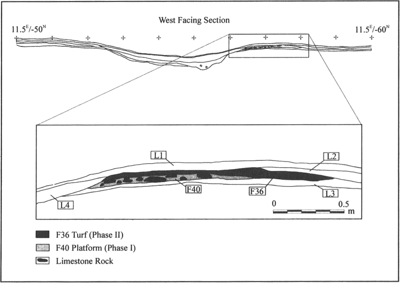
At the southern end of the dwelling, constructed directly on top of the platform (Feature 42) was an arrangement of flat limestone rocks (Feature 40). These rocks varied in size from 10 cm2 to 22 cm2 and averaged 2-3 cm thick. They were carefully arranged to fit together to form a flat "bench" one course high and measuring 2.16 m long by 1.64 m wide (Figure 6). Many of the gaps between the larger stones were filled with small fire-cracked rocks. The southern limit of the bench stopped abruptly to form a gentle semi-circle that mirrored the curvature of the central depression. This clearly marked the position of the wall line of the dwelling.
Figure 1
Location of Point Riche

Figure 2
Map of the Middle Dorset Palaeoeskimo dwellings and natural depressions at Point Riche

Figure 3
Harris Matrix for House Feature 30

Figure 4
Excavation plan of House Feature 30: Phase I

Figure 5
Profile through the eastern platform area of House Feature 30 showing earth bank Feature 45

Figure 6
Profile through the southern platform area of House Feature 30 showing stone bench Feature 40
Running north-south through the centre of the depression was a linear arrangement of limestone cobbles (Feature 60) 1.44 m long by 0.78 m wide. The majority of the rocks were water-worn limestone cobbles ranging in size from 0.08 m to 0.16 m in diameter. Distributed between these were occasional flat limestone rocks ranging in size from 0.07 m2 to 0.18 m2 and averaging 0.04 m thick. This feature terminated at its southern end in a large flat eroded limestone slab (Feature 61). These two features formed a central axial feature to the dwelling.
Establishing the location of the dwelling's entranceway was difficult, as there was no clear architectural evidence of one. However, a gap in the compacted earth floor was noted on the western side of the dwelling. This area also coincided with a gap in the artifact distribution as well as a strange low magnetic anomaly in the magnetometer survey conducted prior to the excavation of the dwelling (Figure 7). Therefore, this is the most likely position for the entrance.
On the floor of the central depression were the remains of an occupation deposit (Feature 59). It consisted of numerous crushed bone chips, occasional charcoal flecks and a number of artifacts including a whetstone, sections of sled runner and a piece of worked whale rib, that may have been an element of the superstructure of the house. This floor deposit also produced a radiocarbon date of 1650 ± 40 B.P. (Beta-160980 uncalibrated) on a piece of wood charcoal. Towards the southeastern corner of house platform was a collection of four irregular limestone rocks that formed a sub-rectangular feature 0.65 m long, 0.40 m wide and 0.08 m high (Feature 48). These rocks possibly served as a pot stand, although this interpretation remains tentative as the stones showed no evidence of fat stains or of burning.
Phase II
The dwelling experienced a period of abandonment, during which time up to 0.17 m of gravel (Feature 54) eroded into the central depression. The reoccupation of the dwelling is marked by the re-establishment of a large central limestone slab (Feature 46) 0.92 m long, 0.62 m wide and 0.10 m thick inside the depression, placed directly on top of the eroded gravel (Feature 54) (Figure 8). Although the function of this slab is unclear, its similar size and placement to the slab (Feature 61) identified at the terminal end of an axial feature in the first phase of occupation, indicates that it may have had a similar function. The living platform around the house was modified with the addition of turf "matting" (Features 31 and 36) averaging 8 cm thick. It was discontiguous and amorphous in shape, covering an area around the northern, southern and eastern sides of the depression up to 1.65 m wide.
A large pit (Feature 47) 1.18 m long, 0.70 m wide and 0.21 m deep was cut into the centre of the southern face of the central depression immediately beside the stone slab (Feature 46). The pit fill was a dark grey silt but contained no finds thus providing little clue to its function. A shallow, U-profiled post-hole (Feature 55) 0.24 m in diameter and 0.08 m deep and a vertical sided, irregular bottomed stake-hole (Feature 56) 0.22 m long, 0.23 m wide and 0.27 m deep were located in the centre of the house, cut into the eroded gravel. Their location through the central axis of the dwelling suggests that they either functioned as part of the axial feature, or more probably held roof supports.
Figure 7
Magnetometer survey of House Feature 30 showing the location of a possible entranceway (the white tail emanating out of the western side of the depression)

Figure 8
Excavation plan of House Feature 30: Phase II

External features
At a distance of approximately 2 m around the outside of the house were a number of small features (Figure 4). Although there was no stratigraphic relationship between these features and the dwelling (Figure 3), their spatial proximity and regular placement around it suggest that they relate to its occupation. It was, however, impossible to establish whether they related to the first or second phase of occupation. Nor was any evidence of post-holes found near these features that would have indicated windbreaks or any other type of shelter associated with them. The possibility of snow structures is also unlikely, as two of the features had been cut into the earth substrate, suggesting that there was no snow cover at the time of their construction and use. It is probable, therefore, that they were open to the elements.
To the east of the house was an arrangement of flat, irregular-shaped limestone rocks (Feature 39) piled into two stacks 12 cm apart that formed a structure approximately 50 cm square and 13 cm high (Figures 8 and 9). One stack was constructed from four stones, the other, although having tipped over, was easily reconstructed to form a pile five stones high. The stones ranged in size from 15 cm to 38 cm long and 9 cm to 17 cm wide, and average 3 cm thick. A single long sub-rounded stone 23 cm long and 5 cm in diameter abutted these two piles at 90° to form the southwestern side of the feature. The stone stacks were constructed in a shallow round pit (Feature 57) 0.70 m long, 0.66 m wide and 0.09 m deep with flat base and gently sloping sides. Small flat limestone rocks averaging 8 cm2 lined the base of the pit and formed the foundation to the feature. The rest of the pit was filled with a dark black greasy soil (Feature 44). Based on the greasy soil surrounding the feature, it probably functioned as a pot stand used to support a soapstone cooking vessel.
Two metres west of the house, directly outside the entranceway to the dwelling, was an arrangement of three sub-rectangular limestone rocks that formed a small stone pad (Feature 38) 39 cm long, 35 cm wide and 10 cm high (Figure 10). The stones ranged in size from 15 cm by 8 cm to 30 cm by 20 cm. Most showed signs of severe heating and were discoloured to a blackened red colour. Many had also crumbled to a pinkish-white grit, particularly in the centre of the feature. Immediately to the south of the stone pad were two large, sub-angular beach pebbles, which may also belong to the feature. Despite the clear signs of intense heating, no evidence of charcoal was observed in association with this feature. Although clearly a hearth of some description, its precise nature is unclear. Renouf (1992: 56) found a similar structure (Feature 10) in the vicinity of House Feature 8 at Point Riche. She likened it to the heating platforms found in northern Norway during the Younger Stone Age, which acted as a form of stovetop. Feature 38 may have functioned in a similar fashion.
Figure 9
Plan and profile of pot stand Feature 39

Figure 10
Plan and profile of heating platform Feature 38

Another hearth (Feature 35) was situated approximately 3 m north east of the house. Unlike Feature 38, no arrangement was made to formalize it. It consisted of a small sub-rectangular pit 0.70 m long, 0.52 m wide and 0.08 m deep. Its fill contained charcoal flecks and burnt pieces of soil.
Several large flat limestone slabs (Features 34 and 53) were also identified around the dwelling (Figure 4). Feature 34 was an irregular arrangement of flat angular limestone rocks distributed over an area 2.10 m long and 1.80 m wide, approximately 1.40 m northeast of the dwelling. The stones ranged in size between 20 cm2 and 70 cm2 and averaged 4 cm thick. All the stones were weathered to a white powdery finish. Feature 53 was a sub-rectangular eroded flat limestone slab 0.75 m long, 0.44 m wide and 5 cm thick situated 2 m southwest of House Feature 30. The function of these stone slabs in unknown. No artifact distributions were closely associated with them, nor was there any indication of use exhibited on their surface, although surface erosion makes survival of such evidence unlikely. They may have acted as some form of tent fixing, perhaps acting as weights for the skin walls of the dwelling.
Artifact distribution
Associated with House Feature 30 were 194 artifacts and 2,126 flakes (Figure 11). No attempt is made in the following description to assign artifact distributions to either of the two phases of occupation identified for the dwelling, as only one cultural horizon (Level 2) was identified outside the dwelling, making it impossible to assign any given artifact to a particular phase. The distributions, therefore, represent a palimpsest from the two occupations.
The majority of cores (65%, N=17) and preforms (80%, N=16) were found outside the dwelling. Conversely, all of the scrapers (N=5), abraders (N=2), the vast majority of the pumice abraders (92%, N=36) and slightly more tip flute spalls (63%, N=24), microblades (59%, N=17) and endblades (57%, N=13) were located inside the dwelling. In addition, examination of the reduction stages of the flake debitage demonstrates that although secondary and tertiary flakes were found in equal proportions both inside and outside the dwelling, the vast majority (84 %, N=31) of the primary flakes were found outside. The presence of most of the preforms, cores and primary flakes outside the dwelling suggests that most of the primary stages in chipped stone tool manufacture took place outside the house. This contrasts with the interior of the dwelling where the artifact types point more towards the latter stages of tool production including the maintenance of endblades and particularly activities associated with grinding. The higher proportion of scrapers and microblades in the dwelling is also notable. These tools suggest that more processing activities were also taking place inside the dwelling.
Figure 11
House Feature 30 artifact distribution

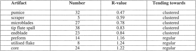
The distributions also indicate a tendency towards the clustering of artifacts, particularly inside the entranceway and immediately northeast of the dwelling. This is confirmed through quantitative spatial analyses using the nearest neighbour analysis technique, a descriptive statistic that examines the spatial arrangement of a pattern of points within a defined study area (McGrew and Monroe 2000: 172). In nearest neighbour analysis, the Euclidean (straight-line) distance of each point to its "nearest neighbour" is determined. The average nearest neighbour distance is then calculated from these distances. The spacing between points is then analysed by comparing the observed average distance between points to an expected average distance for a particular type of distribution (e.g., a random or Poisson distribution) (ibid.: 173). Results are given as an "R" value and described as tending towards dispersed, random or clustered. The R-value will lie somewhere on a continuum in the nearest neighbour index, the extreme ends of which are represented by perfectly clustered and perfectly dispersed distributions. The R-value for a perfectly clustered set of points will always be zero, as all points would lie directly on the same spot and therefore have zero distance between them. The R-value for a perfectly dispersed pattern varies, as it is a function of the point density and will therefore change depending upon the number of points within the study area (ibid.: 174). However, it will always be higher than 1.0, which is the "R" value for a perfectly random distribution. Any value higher than 1.0 will therefore be tending towards a dispersed distribution; the higher the value above 1.0, the more regular the distribution[2]. The analysis was conducted in the GIS software Archinfo using the nearest neighbour analysis extension version 1.0. The results of the nearest neighbour analysis are presented in Table 2.
Table 2
Results of nearest neighbour analysis
The most notable cluster outside the dwelling is the dense collection of flakes and tools (Feature 41) approximately one metre northeast of the house (Figure 11). This includes hundreds of flakes, two microblades, three cores, six endblade preforms, five tip-flute spalls and five endblades. It is not clear whether this distribution is a small refuse dump or represents a tool manufacture area. However, the distribution of Feature 41 (particularly indicated by the flake debitage) is reminiscent of Binford's (1983: Figure 87) observation of the debitage pattern resulting from tool manufacture, which produces an arc around the legs of the flint-knapper. This, in conjunction with artifacts' association with the hearth (Feature 35) (assuming the two are contemporary) suggests that it is a manufacturing area. The artifact classes in Feature 41 indicate that the assemblage was primarily the product of endblade manufacture.
There were also many artifacts immediately west of the dwelling, including three microblades, four cores, seven tip-flute spalls, a single piece of pumice and numerous flakes, though the distribution is more dispersed. The presence of material immediately outside and/or on either side of an entranceway is often associated with the build up of household refuse as the occupants discard their waste on either side of the entrance (Graham et al. 1982: 117; Morrison 1983: 53; Newell 1988: 203). Therefore, many of the artifacts located to the west of the dwelling probably result from this activity.
Discussion of the distribution of artifacts within the house is complicated by the possibility of floor coverings. If skins had been used to cover the floor of the dwelling, the position of artifacts would have shifted when the occupants dismantled the dwelling and removed the skin floors. Demonstrating the presence or absence of skin flooring is clearly difficult without the necessary preservation conditions, and one can only rely on the distribution of artifacts themselves to provide clues. Examination of the artifact and flake distribution inside the dwelling, which shows the clustering of pumice and scrapers in separate locations (Table 2 and Figure 11) suggests that the distributions are representative of activities and not random collections of artifacts after floor skins have been removed and shaken clean. It appears therefore, that much of the floor inside the dwelling probably remained uncovered or was covered with a material that allowed artifacts to percolate through to the ground. Evidence of turf matting (Features 31 and 36) used in the second phase of occupation suggests that this was the case and probably remained the main provision for the dwelling's floor. Such an arrangement is reminiscent of ethnographic descriptions of a typical Nunamiut itchelik (tent) where the floor was covered with willow boughs and only the inner-most third was covered by skins (Ingstad 1954: 39) and the Padlirmiut tent (Birket-Smith 1929: Figure 16) where only the back of the tent was covered with skins, the rest of the floor consisting of bare gravel. Two relatively artifact free areas on the northeastern and southeastern sections of the platform of House Feature 30 may indicate that skins were used in these areas.
The most distinct cluster inside the dwelling was the collection of pumice abraders immediately inside the entranceway. Twenty-nine of the 39 excavated examples were found here. Their function has yet to be demonstrated, but pencil sized grooves present on many of the abraders indicate that they were used to manufacture shafts or some other linear object. Eight tip-flute spalls and eight endblades concentrate in the same general area, indicating that this was also a favoured spot for the maintenance of endblades. One other possible activity area inside the dwelling is situated near the stone "bench" (Feature 40). Four out of the five scrapers were found within 75 cm of this feature.
Superstructure
Although House Feature 30 remains one of the better preserved excavated examples of a Middle Dorset dwelling on the island of Newfoundland, determining the nature of its superstructure has proved difficult. Organic preservation is generally very poor and most of the materials that would have been used in the dwelling's construction have not survived. Interpretations are therefore at best tentative and require evidence from a number of similar dwellings identified at Point Riche and the coeval Dorset site at nearby Phillip's Garden.
The building material used for the framework of the dwelling was probably whalebone ribs and wood. The use of whalebone is based on evidence from a number of dwellings, most particularly House Feature 55 at Phillip's Garden where five of 12 post-holes around the dwelling showed evidence of curvature. This pit orientation suggests that whale ribs were used for some of the structure's framework, as they have the necessary curvature to bend back towards the centre of the dwelling to form a dome (Renouf 2002: 98). Although no post-hole ring was identified for House Feature 30 (one can be reasonably sure that no post-hole ring existed as cuts were clearly visible in the earth substrate), a small section of worked whalebone was found in the centre of the dwelling and may represent the remains of its original framework. A larger piece of whalebone nearly one metre long and 15 cm wide was also identified in the centre of House Feature 8 at Point Riche and was interpreted as a possible piece of the dwelling's superstructure (Renouf 1987: 32). It is possible, therefore, that the inhabitants at Point Riche used whalebone in the construction of their houses.
Given the absence of a post-hole ring for House Feature 30, it is probable that the framework of the dwelling was free standing and lashed together to form a rigid frame. The post-hole and a stake-hole in the centre of the dwelling indicate that central posts supported the weight of the roof. The lack of post-holes at Point Riche might be a function of the substrate at the sites. Point Riche has a relatively loose limestone gravel substrate, with only a thin spread of soil on top. Loose gravel would have provided unstable foundations for posts and probably made post-holes tedious to construct as the edges would have continuously eroded. This is supported by the only post-hole (Feature 55) identified at Point Riche in the centre of House Feature 30, which was shallow and poorly constructed.
There is even less evidence for materials used to construct the dwellings' roof or walls at Point Riche. The walls were most likely seal skin, which would have been available in great abundance. The thin spread of turf identified around House Feature 30 may have been used as additional insulation for the walls, although most of it appears to have been used primarily as flooring during the second phase of occupation. The dwellings were built on a soil horizon (Level 3), indicating that turf would have been readily available on site if required.
Conclusion
House Feature 30 provides an unusually well-defined example of a Middle Dorset dwelling. The use of magnetometer survey and total excavation of House Feature 30 along with the fortunate absence of rocks in the substrate at Point Riche, facilitated the identification of clearly defined wall outlines, an entranceway, post-holes, two hearths, a pot-stand and other external features. Complete excavation and dismantling of the dwelling ensured that all visible architectural remains were recorded, including the demonstrable absence of a post-hole ring, and permitted the identification of two distinct phases of occupation. House Feature 30 at Point Riche should become a useful comparison for other researchers interested in Dorset dwelling architecture, and may perhaps encourage a return to some incompletely excavated dwellings.
Appendices
Acknowledgments
I would like to thank Priscilla Renouf, who generously handed the Point Riche project to me for my Masters research as well as providing advice and assistance throughout the project. Many thanks also to the granting agencies for their financial support. These included the Canadian Parks Service who funded the major portion of the field season. Substantial amounts were also provided by the Institute of Social and Economic Research, the J.R. Smallwood Foundation for Newfoundland and Labrador studies, the Culture and Heritage Division, Government of Newfoundland and Labrador, and the Social Sciences and Humanities Research Council of Canada. I would also like to thank the Newfoundland Archaeological Heritage Outreach Program for the financial support during my two years of study. I am also indebted to Jeremy Taylor for flying out to Newfoundland to supervise the geophysical component of the field season and Lisa Hodgetts for both identifying the faunal material and for her comments on an earlier draft of this paper. I would also like to thank the two anonymous reviewers for their comments. Of course, any errors or omissions remain my own.
Notes
-
[1]
Although this terrace is approximately 100 m away from the present shoreline, it was probably considerably closer during the Dorset occupation of the site. Renouf and Bell (1997: 54) have suggested that the "Type A" sea level curve is the most appropriate for the Port au Choix region. The "Type A" curve shows sea levels approximately 1-2 m above current levels during the period when the Dorset Palaeoeskimo occupied the site, which would put the shoreline approximately 50 m from the site.
-
[2]
It should be noted, however, that as the "R" value for a perfectly dispersed pattern is a function of the point density, the "R" values of different assemblages cannot be directly compared. The test merely establishes the general level to which the different artifact classes are clustered, randomly dispersed or regularly dispersed
References
- Binford, Lewis, 1983 In Pursuit of the Past: Decoding the Archaeological Record, New York, Thames and Hudson.
- Birket-Smith, Kaj, 1929 The Caribou Eskimos. Material and Social Life and their Cultural Position, Copenhagen, Gyldendalske Boghandel, Nordisk Forlag, Report of the Fifth Thule Expedition 1921-24, 5(1-2).
- Department of Mines and Energy, 1992 Port Saunders/Torrent River (western margin), Newfoundland Map 91-174. 1: 50,000, Geological Survey Branch, Department of Mines and Energy, Government of Newfoundland and Labrador.
- Eastaugh, Edward J.H., 2002 The Dorset Palaeoeskimo Site at Point Riche, Newfoundland, An Intra-Site Analysis, M.A. thesis, St. John's, Memorial University of Newfoundland, Department of Anthropology.
- Eastaugh, Edward J.H. and Jeremy Taylor, In press Geophysical survey of a Dorset Palaeoeskimo site at Point Riche, Newfoundland, in T. Bell and M.A.P. Renouf (eds), Humans on the Landscape, St. John's, Interdisciplinary studies at Port au Choix, Special Issue of Newfoundland Studies.
- Fogt, Lisa, 1998 The Excavation and Analysis of a Dorset Palaeoeskimo Dwelling at Cape Ray, Newfoundland, M.A. thesis, St. John's, Memorial University of Newfoundland, Department of Anthropology.
- Graham, Martha, Coral Raish and Lynne Sebastian, 1982 Site Structure and Nunamiut Ethnoarchaeology, Haliksa'I, 1: 110-119.
- Harp, Elmer, 1976 Dorset Settlement Patterns in Newfoundland and Southeastern Hudson Bay, in M. Maxwell (ed.), Eastern Arctic Prehistory: Palaeoeskimo Problems, Washington, Memoirs of the Society for American Archaeology: 119-138.
- Hartery, Latonia and Tim Rast, 2001 Bird Cove Archaeology Project 2000 Field Season: Final Report, unpublished report on file, St. John's, Government of Newfoundland and Labrador, Department of Tourism, Culture and Recreation, Provincial Archaeology Office.
- Ingstad, Helge, 1954 Nunamuit, New York, W. W. Norton and Company.
- McGrew, Chapman and Charles B. Munroe, 2000 An Introduction to Statistical Problem Solving in Geography, Second Edition, New York, McGraw-Hill Higher Education.
- Morrison, David A., 1983 Thule Culture in Western Coronation Gulf, N.W.T., Ottawa, Canadian Museum of Civilization, Archaeological Survey of Canada, Mercury Series, 115.
- Newell, Raymond R., 1988 The Intermound and Extramound Tests, in E.S. Hall and L. Fullerton (eds), The 1981 Excavations at Utqiagvik Archaeological Site, Barrow, Alaska, Barrow, North Slope Borough Commission on Inupiat History, Alaska Language and Culture, 1: 174-262.
- Renouf, M.A. Priscilla, 1985 Archaeology of the Port au Choix National Historic Park, Halifax, Parks Canada, Atlantic Region, Archaeology Division.
- Renouf, M.A. Priscilla, 1986 Report of 1985 Excavations at the Point Riche and Phillip's Garden Sites, Port au Choix National Historic Park, unpublished report on file, Halifax, Parks Canada, Atlantic Region, Archaeology Division.
- Renouf, M.A. Priscilla, 1987 Archaeological Investigations at the Port au Choix National Historic Park: report on the 1986 field activities, unpublished report on file, Halifax, Parks Canada, Atlantic Region, Archaeology Division.
- Renouf, M.A. Priscilla, 1992 The 1991 Field Season at Port au Choix National Historic Park, unpublished report on file, Halifax, Parks Canada, Atlantic Region, Archaeology Division.
- Renouf, M.A. Priscilla, 1993 The 1992 Field Season, Port au Choix National Historic Park, Report of Archaeological Excavations, unpublished report on file, Halifax, Parks Canada, Atlantic Region, Archaeology Division.
- Renouf, M.A. Priscilla, 2002 Archaeology at Port au Choix, Northwestern Newfoundland 1990-1992, St. John's, Copetown Press, Occasional Papers in Northeastern Archaeology, 12.
- Renouf, M.A. Priscilla and Trevor Bell, 2000 Integrating Sea Level History and Geomorphology in Targeted Archaeological Site Survey: The Gould Site (EeBi-42), Port au Choix, Newfoundland, Northeast Anthropology, 59: 47-46.
- Renouf, M.A. Priscilla and Maribeth S. Murray, 1999 Two Winter Dwellings at Phillip's Garden, a Dorset Site in Northwestern Newfoundland, Arctic Anthropology, 36: 118-132.
- Robbins, Douglas T., 1985 Stock Cove, Trinity Bay: the Dorset Eskimo Occupation of Newfoundland from a Southeastern Perspective, M.A. thesis, St. John's, Memorial University of Newfoundland, Department of Anthropology.
- Stuiver, Minze and Bernd Becker, 1986 High Precision Decadel Calibration of the Radiocarbon Time Scale, AD 1950-2500 BC, Radiocarbon, 28 (2B): 863-910.
List of figures
Figure 1
Location of Point Riche
Figure 2
Map of the Middle Dorset Palaeoeskimo dwellings and natural depressions at Point Riche
Figure 3
Harris Matrix for House Feature 30
Figure 4
Excavation plan of House Feature 30: Phase I
Figure 5
Profile through the eastern platform area of House Feature 30 showing earth bank Feature 45
Figure 6
Profile through the southern platform area of House Feature 30 showing stone bench Feature 40
Figure 7
Magnetometer survey of House Feature 30 showing the location of a possible entranceway (the white tail emanating out of the western side of the depression)
Figure 8
Excavation plan of House Feature 30: Phase II
Figure 9
Plan and profile of pot stand Feature 39
Figure 10
Plan and profile of heating platform Feature 38
Figure 11
House Feature 30 artifact distribution
List of tables
Table 1
Radiocarbon dates from Point Riche (all samples come from wood charcoal)
Table 2
Results of nearest neighbour analysis