
Résumés
Abstract
This paper reviews and summarizes information about Palaeoeskimo dwelling structures in the Province of Newfoundland and Labrador with the aim of producing a basic resource and research tool. Patterns are noted and some are related to residential mobility.
Résumé
Cet article passe en revue et résume l'information concernant les structures d'habitations paléoesquimaudes de la province de Terre-Neuve et du Labrador dans le but de produire à la fois une base de données et un instrument de recherche. Des tendances sont identifiées; certaines liées à la mobilité résidentielle.
Corps de l’article
Introduction
This paper reviews the available information on Palaeoeskimo dwelling structures in Newfoundland and Labrador and summarizes a number of patterns for the two regions. The paper concludes with a consideration of the implications of these patterns for mobility and group size. The primary focus is the physical attributes of the dwelling structure. This is the fundamental level of evidence upon which all subsequent analyses are based, such as spatial studies (Kent ed. 1990; Grøn et al. eds 1991), seasonal and functional interpretations (Binford 1990; McGuire and Schiffer 1983; Park 1988), and reconstruction of social (Dawson 2002; Mauss and Beuchat 1979 [1906]; Tanner 1991) and ideological (Odgaard 2001; Tanner 1979; Yates 1989) space. This synthesis of architectural information is intended as a basic resource and research tool.
Methodology
The geographical area of this review is the Province of Newfoundland and Labrador. Information is based on published papers, unpublished theses and unpublished site reports. Information solely available on Provincial Archaeology Office Site Record Forms is excluded. The only dwelling structures reviewed are those for which there is sufficient information for at least some description. Dwellings that were minimally tested or described are not included, for example the unexcavated Middle Dorset dwelling depression observed at Manual Island, Hopedale (Fitzhugh 1976: 128), the hearth features noted but not described at the Groswater Ticoralak sites in Hamilton Inlet (Fitzhugh 1972: 86-88), and the Groswater axial feature mentioned at the Cow Head site on the Northern Peninsula of Newfoundland (Tuck 1978). Figure 1 shows site locations and Tables 1-3 summarize dwelling details. Excavators' original feature designations are used in tables and text.
The data are necessarily inconsistent, affected as they are by the variable contexts of collection, description, interpretation, and taphonomy. Archaeological surveys of the 1970s focussed on culture history (Cox 1978; Fitzhugh 1972, 1980; Linnamae 1975; Tuck 1975, 1978) and settlement patterns (Cox 1977; Fitzhugh 1972). These surveys and excavations placed different emphasis on dwelling structures than later projects which had a focus on site seasonality and function, where the dwelling was a primary source of information (Eastaugh 2002; Fogt 1998; Harp 1976; Renouf 1994; Renouf and Murray 1999). Particular excavation and data recording techniques were appropriate to particular research questions. A focus on dwelling architecture necessitated plan excavation that exposed large surface areas and required detailed recording of structural features and associated data. A more culture-historical or settlement history focus was better served by large scale archaeological surveys and limited excavation without a major emphasis on spatial data.
Inconsistency in data recording is further affected by the interpretation embedded in all archaeological descriptions. To make sense of a small grouping of rocks, it may be described as a hearth, or a larger ring of stones may be identified as a tent ring, and so on. In reports and published accounts, back-up maps or photographs to verify these and similar interpretations may be present or absent, depending on the importance the structural remains were given at the time of excavation. Oftentimes the absence of back-up information makes it difficult to assess the accuracy of the original interpretation.
Taphonomic factors contribute to variability in the preservation, condition and context of data. A dwelling structure may be well-preserved at one site, while at another it may have been disturbed by a variety of natural and cultural post-depositional processes, for example tree growth or post-occupation re-use. All things being equal, a structure used only once will be less disturbed and easier to record and interpret than a structure that has been re-used, re-built or repaired over a period of years or even generations. Original structural materials directly affect preservation: sod, earth, bone and wood are susceptible to decay, leaving a more subtle imprint than a structure with a perimeter or foundation of stone. Modern vegetation will affect the visibility of dwelling remains: surface structures are more difficult to find where there is overgrowth, for instance many areas in Newfoundland, compared to those that are barren or sparsely vegetated, such as large areas of coastal Labrador.
Figure 1
Location of sites mentioned in the text

Keeping these caveats in mind, I have systematized available information in so far as possible, primarily through a summary of each structure's architectural elements in table form (Tables 1-3). Within each table, sites are presented in a north-to-south distribution. Attributes are abbreviated, with a key at the end of each table. While these tables appear overwhelmingly detailed at first glance, they will reward close examination.
Terminology
I try to use terminology consistently in this review. I avoid using the terms "house," "tent" or "tent-ring" since these imply certain things about function, seasonality and duration of use. Instead I use the more neutral terms "dwelling," "dwelling remains," "dwelling structure" and "structure" (in a context where dwelling is understood) which imply only that the structure once gave shelter to people.
There are other potentially confusing terms, for example, "mid-passage hearth." The term first came into use in Knuth's (1966-67; Grønnow and Jensen 2003) review of Palaeoeskimo dwellings in Greenland where he and others found what he called "mid-passage hearths" or "hearth passages" in Independence I and II dwelling structures. These mid-passage hearths were very well-defined. Two parallel lines, about 1 m apart, of upright flagstones ran through the centre of the dwelling. Within these vertical lines were three internal divisions demarcated by transverse upright flagstones: one central box hearth and two adjacent compartments. In Independence II dwellings, the longitudinal axis of the feature often expanded to the rear of the dwelling forming "wings." Knuth (1966-67: 204) speculated that these were storage areas and possibly even back supports for seated persons. The term "mid-passage feature" has since come to be used to refer to less well-delineated but nevertheless linear slab and/or cobble features that bisect the interior of a dwelling. In response to this, Jensen (1993) usefully contrasted mid-passage hearths characterized by a vertical dimension (upright slabs) with the less well-defined axial features and axial pavements characterized by a horizontal dimension (cobbles and flat slabs). I use the general term "axial feature" to apply to all linear features that cross-cut the interior of a dwelling, or sometimes occur outside a dwelling or without any dwelling apparent. Where axial features occur, the presence or absence of vertical slabs, box hearths, associated pavements and wings, are detailed in Tables 1-3.
Another potentially confusing term is "box-hearth," or square hearth (Knuth 1966-67: 196), which refers to a roughly square hearth formed by four upright slabs. It may or may not have a slab base and a cover. It may be filled with fire-cracked rocks or have residues of burned fat and/or charcoal. In some cases a square hearth is formed by two transverse stones across the axial feature, with the sides of the axial feature forming the other two sides of the hearth. I apply the term "box hearth" to both versions of square hearth. A box hearth can also function as a lamp support.
The term "lamp support" refers to any stone that defined the placement of a soapstone lamp or larger cooking vessel. A lamp support may be two upright slabs between a basal slab (a box hearth), a notched upright stone, or a flat stone stained by a spill of blubber which might even outline the shape of the lamp. Lamp supports may be an integral part of an axial feature or can occur elsewhere within a dwelling. A soapstone vessel and its support functioned as a hearth.
The term "bilobate" refers to a dwelling shape where there is a lobe on each side of an axial feature. However, when viewing plan maps and photographs it sometimes seems that the presence of two lobes versus a continuous oval/circular outline is largely in the eye of the beholder. For the sake of retaining original information, I use the term "bilobate" where the excavator used it, keeping in mind the often subjective nature of its application.
"Semi-subterranean" refers to a dwelling structure that is recessed into the ground, even shallowly. This contrasts with a surface structure which has not been dug into the ground.
The term "entrance passage" is used to refer to a long entrance to a dwelling which, by virtue of its length (2-3 m), reduced drafts entering the dwelling. Some entrance passages dipped below the level of the interior floor, to trap drafts more effectively; this kind of entrance is often called a cold-trap or tunnel entrance, although these terms are not used here.
Pre-Dorset
Pre-Dorset sites in the Province are found from northernmost Labrador to Nain, although Tuck also reported some possibly Pre-Dorset material from the Cow Head site on the Northern Peninsula of Newfoundland (Tuck 1978: 139). The most completely reported Pre-Dorset dwelling structures are from Okak (Cox 1977, 1978, this volume) and Nain (Fitzhugh 1976, 2002).
Okak
In Okak, Pre-Dorset dwelling features are reported from Green Island 3 (HjCk-4), Sipukat Bay 1 (HjCn-1) and Nuasornak 2 (HiCl-1).
Green Island 3: This site is on a 19.5 m sand and gravel terrace on protected Green Island; both Maritime Archaic Indian and Pre-Dorset material were present (Cox 1977: 120-122). Cox described four disturbed and poorly defined dwelling structures on the terrace, each small, roughly circular, with no internal features and defined on the basis of perimeter rocks. He called these structures possible tent rings and noted that, while he could not positively identify their cultural association, most of the cultural material around them was Pre-Dorset. No photographs or drawings of the structures were presented.
Sipukat Bay 1: This site is on a 10.7 m hill within the shelter of an inner coastal island (Cox 1977: 230). Cox reported six rock concentrations one of which, although disturbed, he identified as a dwelling. He described this as roughly circular with a cobble axial feature, at each end of which were two possible cobble hearths. A map and photograph (Cox 1977: 230, 467) showed what appeared to be an axial feature within an oval or bilobate structure, only one half of which had enough rocks to clearly suggest the dwelling outline (Figure 2). These structures were identified as Pre-Dorset based on artefacts from the larger site area.
Nuasornak 2: This site lies on a series of five sand-and-gravel terraces on a small sheltered island. There were many dwelling features on the terraces and a number of structures were excavated (Cox 1988, this volume). Cox described a Pre-Dorset axial feature (FS-2) and a Pre-Dorset dwelling structure (S-26) on the 10 m terrace and another Pre-Dorset dwelling structure (S-4) on the 7.9 m terrace. The Pre-Dorset structures were identified on the basis of artefacts and radiocarbon dates associated with the axial feature, FS-2 (3960 ± 100 B.P.[1]; Beta 25199) and dwelling S-4 (4250 ± 90 B.P.; Beta 25200 and 3210 ± 80 B.P.; Beta 25198) (Cox, this volume). To summarize Cox's detailed descriptions and plan drawings, the two dwellings were small surface structures, one bilobate and the other oval/sub-rectangular, as outlined by perimeter cobbles. Each had an axial feature, in one case composed of cobbles and in the other consisting of columnar rocks. The stand-alone axial feature may or may not have been associated with a dwelling.
Nain
In Nain there are four Pre-Dorset sites with dwelling structures, Koliktalik 8 (HdCg-25), Dog Bight L 5 (HdCh-5), Nukasusutok 2 (HeCh–5) and Imilikuluk 8 (HdCg-36).
Koliktalik 8: Fitzhugh (1976: 135) briefly described a small dwelling structure at this site, attributable to Pre-Dorset on the basis of raw material and two diagnostic tools. He noted that the structure had been built up against a natural outcrop which served as a rear wall and that it was roughly heart shaped with two cleared lateral areas on each side of a cobble axial feature. No dimensions, plans or photographs were provided.
Dog Bight L 5: Three dwelling structures were found at Dog Bight L 5, on the southeast end of Dog Island, at the front of the 14-15 m terrace (Fitzhugh 1976: 130). These dwellings were originally interpreted as Groswater based on a few brown and mottled fine-grained chert flakes (characteristic of Labrador Groswater), although the similarity to other Pre-Dorset structures was noted (Fitzhugh 1976: 130-131). Since then the structures have been identified as Pre-Dorset on the basis of elevation, the presence of Mugford chert (characteristic of Labrador Pre-Dorset), and a date of 3810 ± 75 B.P. (SI 2521) from an associated hearth (Cox 1978: 99; Fitzhugh 2002: 136). Each dwelling had a well-defined cobble axial feature, with a central box-hearth of thick slabs constructed around a basal slab; in House 1 the basal slab was covered with charred fat (Fitzhugh 1976: Figures 6-8). House 2 had cleared lateral areas and the walls were defined by perimeter rocks. No further details were given about these structures, but there were excellent photographs (Fitzhugh 1976: 132-33) and maps (Cox 1978: 101) of both.
Imilikuluk 8: Fitzhugh (1976: 135) described a Pre-Dorset structure on Imilikuluk Island as a small circular structure without an axial feature and identified it as Pre-Dorset on the basis of the presence of true burins.
Nukasusutok 2: Two dwellings were reported from this site, on a high gravel terrace within a sheltered bay on the north side of Nukasusutok Island (Fitzhugh 1976: 135, 2002: 139). The dwellings were defined as terminal Pre-Dorset on the basis of artefacts and a radiocarbon date on burned blubber of 3315 ± 85 B.P. (SI 2988), corrected to 3055 ± 85 B.P. (Fitzhugh 2002: 146). The two structures were particularly well-defined and are well-described in text, photographs and maps (Fitzhugh 2002). Structure 1 was bilobate, with a clearly-defined axial structure consisting of a four-sided slab box hearth with boiling stones and a possible cover nearby, an open hearth area, and a second, two-sided, box hearth made of double upright slabs between which was a basal slab. This slab was encrusted with charred fat suggesting that the box hearth had functioned as a lamp support (Fitzhugh 2002: 141). A terminal slab occurred at the north and south ends of the axial feature, and to the rear and at one side was a small paved winged area. Fitzhugh (2002: 140) suggested that originally the dwelling structure was outlined by large rocks which, after occupation, were gathered and placed over the axial feature, possibly to construct a cache. Structure 2 was bilobate, the shape clearly outlined by perimeter rocks on either side of a well-defined axial feature. This feature was defined by two lines of upright slabs between which were three hearths: a three-sided slab box hearth with boiling stones and a possible slab cover nearby, a hearth for heating boiling stones, and a box-hearth with two upright slabs between which were fat encrusted basal slabs that suggested its function as a lamp support (Fitzhugh 2002: 141). A small paved winged area was to one side of the axial feature and at each end of the axial feature was a large terminal rock. Fitzhugh (2002:140) noted that these two structures were unusual for Labrador Pre-Dorset and were reminiscent of Independence I and II dwellings from Greenland.
Summary
Of the 16 Pre-Dorset structures described, 14 are detailed enough to be characterized as small oval or bilobate surface structures, some of which are defined by perimeter rocks (N=12) (Table 1). Sizes range from 7.06 m2 to 19.64 m2, with a mean of 12.16 m2. Axial features are common (N=12); most of cobble construction (N=8). The two structures at Nukasusutok 2 have the most clearly defined axial structures, with upright elements and clearly demarcated internal compartments.
Groswater Palaeoeskimo
Groswater Palaeoeskimo sites are found throughout Newfoundland and Labrador. In Labrador, Groswater structures are found around Okak (Cox 1977, 1978, 1988, this volume), Nain (Fitzhugh 1976; Loring 1983) and Makkovik (Loring and Cox 1986). In Newfoundland, Groswater dwellings are found on the Northern Peninsula (Auger 1984; Renouf 1991, 1992, 1993a, 1994, 2002), in the Bay of Islands (Reader 1997, 1998) and in Fleur de Lys (Erwin, this volume).
Okak
There is one Groswater site with dwelling remains in the Okak region, Nuasornak 2 (HiCl-1).
Nuasornak 2: In Okak, two Groswater structures were described at Nuasornak 2 (Cox, this volume). These were identified as Groswater Palaeoeskimo on the basis of artefacts and associated radiocarbon dates. Structure 1 on the 6.7 m terrace was dated to 2150 ± 70 B.P. (Beta 25197) and Structure 3 on the 7.1 m terrace was dated to 2900 ± 90 B.P. (Beta 25197). Both dwellings were small oval surface structures. Structure 1 had a cobble and slab axial feature and although it was somewhat disturbed, a box hearth could be seen at one end (Cox, this volume). Structure 3 had a cobble and slab axial feature with a central box hearth. Cox noted that a layer of pebbles and sand was placed over the hearth and that two upright slabs within the mid passage might have been lamp-supports.
Nain
In the Nain region there are two Groswater Palaeoeskimo sites with possible dwelling remains, Voisey's Bay 1 (HbCl-3) and St. John's Harbour 5 (HeCi-30).
Voisey's Bay 1: The Voisey's Bay 1 site is on a small island deep in Voisey's Bay. Loring (1983: 46-47) described a single structure on the highest terrace which he identified as Groswater Palaeoeskimo on the basis of a small diagnostic tool assemblage. He described the structure as an amorphous linear arrangement of large flat slabs encircling a central area where there was a heavily burned slab thought to be a cooking area. A photograph (Loring 1983: 54) showed slabs which did not form an axial feature; Loring did not identify the structure as a dwelling.
St. John's Harbour 5: Anton (2003) identified a dwelling feature at St. John's Harbour 5, based on 1980 field notes taken by Fitzhugh and his excavation team. This feature was defined as Groswater on the basis of artefacts and two dates of 2190 ± 70 B.P. (SI 4824) and 2540 ± 75 B.P. (SI 4825). An axial feature was described as two double lines of flat stones within which were a number of blubber-stained rocks, interpreted as lamp supports. To each side of the axial features was a cleared area, and part of one side abutted a bedrock outcrop. A detailed plan was provided.
Makkovik
In Makkovik there is one Groswater site with dwelling structures, the Postville Pentecostal Site (GfBw-4).
Postville Pentecostal Site: The Postville Pentecostal Site is at the head of Kaipokok Bay (Loring and Cox 1986). Three dwellings were described, identified as Groswater based on artefacts and three radiocarbon dates ranging from 2975 ± 70 B.P. (SI 2989) to 2230 ± 65 B.P. (SI 3560), although the older date was thought likely to relate to a Pre-Dorset occupation of the site. The descriptions of the structures were quite detailed, although difficult to identify in the plan maps.
Loring and Cox (1986: 68-69) described Structure 1 as a small oval surface structure demarcated by a stone slab pavement and without any identifiable perimeter rocks (Figure 3). In the central area there was an axial feature which consisted of a short shallow trench lined with slabs. Some looked as if they had once been upright, and those at the bottom of the trench were heat-shattered; the excavators interpreted the trench as a possible sunken box hearth. There was another hearth outside the axial feature and there was a small alcove at the dwelling perimeter. Structure 2A was described as a small linear pavement with a hearth at one end. Structure 2B was described as a disturbed paved structure, although on the plan map it looked like a small bilobate structure with a cobble axial feature and a box hearth at one end. Feature 6 was an isolated axial feature that consisted of a linear pavement of flat slabs, at one end of which was a box hearth filled with small fire-cracked rocks. Feature 8 was a disturbed bilobate structure with an axial feature and a central hearth (Loring and Cox 1986: 70).
Northern Peninsula and West Coast of Newfoundland
Groswater Palaeoeskimo dwelling structures are reported from four sites on the Northern Peninsula and the west coast of Newfoundland, Phillip's Garden East (EeBi-1), Phillip's Garden West (EeBi-11), Factory Cove (DlBk-3), and Parke's Beach (DgBm-1).
Phillip's Garden East: Phillip's Garden East is located on the Point Riche headland in the Port au Choix National Historic Park. Two structures were reported, one a small and deep circular depression and the second a larger oval surface structure (Renouf 1994). The first structure was unclear as to function (it might not have been a dwelling) and cultural identification (it could have been Groswater or Dorset) and so is not considered further. The second structure was identified as Groswater based on associated artefacts and a date of 2350 ± 90 B.P. (Beta 50023) (Renouf 2002: 83). This structure, Feature 12, was identified on the basis of a discontinuous but clearly discernable berm of small pieces of fire-cracked rock, small flakes, broken tools, and small bone fragments. This berm was interpreted as a by-product of repeated cleanings of the dwelling interior where smaller debris ended up lodged against the inside walls. Against one side of the dwelling was a cobble pavement interpreted as a platform; there was no axial feature. A well-defined pit occurred within the perimeter of the dwelling and two additional slab-capped pits occurred just outside.
Phillip's Garden West: Phillip's Garden West is not far from Phillip's Garden East on a small 13.5 m terrace with a wide ocean view. One dwelling structure (Feature 25) was identified at the site and dated to 2350 ± 80 B.P. (Beta 49758). Feature 25 consisted of a small circle of five small post-holes which defined a space around a central hearth. Two additional cobble hearths were outside Feature 25 and may or may not be associated. One hearth dated to 2200 ± 110 B.P. (Beta 42973) and the other to 2090 ± 70 B.P. (Beta 49757). The structure was interpreted as a light-weight tent based on the small size of the post-holes and the small area they defined.
Factory Cove: Factory Cove is on the headland of the Cow Head peninsula (Auger 1984). The site was identified as Groswater on the basis of artefacts and three radiocarbon dates, ranging from 2700 ± 140 B.P. (Beta 4047) to 2100 ± 60 B.P. (Beta 4046) (Auger 1984: 42). Auger identified five possible dwelling structures which he described in detail; regretably his structure definitions are difficult to verify in the site plans.
Auger described Structure A as a small almost-square surface structure outlined by perimeter rocks that were slightly larger than the surrounding rocks. There was a rectangular cobble and slab hearth and a small rectangular stone feature, possibly a storage box, inside the dwelling near the perimeter (Auger 1984: 40). Auger described Structure B as a small bilobate surface structure outlined by perimeter rocks surrounding cleared areas on either side of an axial feature (Auger 1984: 43). Auger described Structure C as a small rectangular shallow depression outlined by a perimeter of loose humus mixed with sand. There was no formal hearth but there was an area of fire-cracked rock and charcoal (Auger 1984: 46-47). He described Structure D as a small bilobate surface structure outlined by a perimeter of rocks within which there was an axial feature and a relatively high density of debitage. A possible storage box was located near the wall area (Auger 1984: 48). Structure E was described as a rectangular area of stones associated with a hearth. On the basis of stratigraphy, Auger interpreted the cobbles as originally forming a wall rather than a pavement (Auger 1984: 54). Immediately outside this was a large pit with faunal material in it. Auger interpreted Structure E as a possible lean-to and the other structures as tents.
Figure 2
Plan of Pre-Dorset structure at Sipukat Bay (redrawn from Cox 1977: 231)

Figure 3
Plan of Structure 1, Postville Pentecostal site (redrawn from Loring and Cox 1986: 84)

Parke's Beach: This site is located on a 2-3 m asl beach terrace on a point of land in the mouth of Middle Arm, Bay of Islands. Reader (1997: 1) noted a dwelling structure which he identified as Groswater on the basis of associated artefacts. The dwelling was an oval surface structure defined by a berm of discarded material. Two post-holes were identified, one in the inner edge of the northwest berm and the other in the inner edge of the northeast berm; a break to the northeast was defined as an entrance. Charcoal from a central cobble and slab hearth gave an anomalously recent date of 1270 ± 50 B.P. (Beta 98144).
Cow Cove 1: At Cow Cove 1, in a sheltered cove in Fleur de Lys, a box hearth was identified as Groswater based on associated artefacts (Erwin, this volume). This hearth, on a cobble beach, was comprised of four partially upright slabs enclosing fire cracked rock. Erwin could not see any surrounding perimeter rocks or other features that might have indicated that the hearth was inside a dwelling; however, he noted an adjacent 1 m wide cleared and raised area which he suggested might have been a platform. This can be seen clearly from the site plan, and looks rather like one half a bilobate structure. If a matching side exists it lies beneath a large tree in an unexcavated area of the site. A small pit was located very near the box hearth and another was a couple of metres away.
Summary
Eighteen Groswater dwellings are summarized. They tend to be small oval surface structures, ranging in size from 6 m2 to 28.26 m2 with a mean of 13.35 m2 (Table 2). Labrador and Newfoundland are summarized separately as there are major difference between the two regions. Of the nine structures described for Labrador, eight have axial features, composed of cobbles or cobbles-and-slabs, with one example that incorporates some upright rocks. Terminal (N=5) and central (N=3) hearths are present, all but one of which are box hearths. In two cases lamp supports are part of the axial feature and in one case is part of a non-axial hearth. Slab pavements are common (N=5) and often define the structure (N=4).
By contrast, in Newfoundland, there are no clearly defined axial features, and there is only a single example of a box hearth; no slab pavements have been found. Dwelling shape is variable, including oval (N=3), rectangular (N=3) and bilobate (N=2) structures. There is also variability in dwelling construction, much from Port au Choix. While most Newfoundland Groswater structures are defined by perimeter rocks (N=4), others are defined by a discard perimeter (N=2), a ring of postholes (N=2) or a perimeter of humus and sand (N=1). In Newfoundland, interior and exterior pit features are associated with dwellings (N=5).
Early Dorset
The review of Dorset dwelling structures is organized according to the Early-Middle-Late chronological division of the Dorset cultural period. Only Middle Dorset occupations are known in Newfoundland.
Early Dorset in Labrador occur as far south as Nain. Structures are reported from Saglek Bay (Thomson 1981), Seven Islands Bay (Nagle 1984), Okak (Cox 1977, this volume) and Nain (Hood 1986).
Seven Islands Bay
Only one site with Early Dorset structures is reported from Seven Islands Bay, at Komaktorvik 1 (IhCw-1).
Komaktorvik 1: Komaktorvik 1 is on a sand spit projecting out from the western shore of Komaktorvik fjord, Seven Islands Bay. A group of three oval, shallow depressions were identified as Early Dorset, based the presence of characteristic tools and raw material, along with two dates: 2515 ± 70 B.P. (SI 3896) from House 1 and 2495 ± 70 B.P. (SI 3897) from its associated midden (Nagle 1984: 214). The structures were tested rather than fully excavated.
Saglek
One site with Early Dorset dwellings is reported from Saglek Bay, Shuldham 6 (IdCq-19).
Shuldham 6: Shuldham 6 is located on the southeast tip of the sheltered Shuldham Island in Saglek Bay. Two structures on a 5 m terrace were identified as Early Dorset on the basis of characteristic artefacts, in particular triangular straight-based endblades. There was little information on these structures beyond a brief description that they consisted of flat pavements surrounded by hold-down rocks. One structure was described as having a central passage, or axial feature (Thomson 1981: 12).
Okak
One Early Dorset site with dwelling structures is reported from Okak, Iluvektalik Island 1 (HhCk-1).
Iluvektalik Island 1: Iluvektalik Island 1 is located on a broad beach at 6.7 m asl. Cox (1977: 152-1962) described this as a rectangular semi-subterranean sod structure. The walls were deflated and he defined the size and shape of the structure from the distribution of artefacts and flakes. He identified it as Early Dorset on the basis of artefacts and a date of 2845 ± 60 B.P. (SI 2510). He noted that there did not appear to be an axial feature, nor an entrance passage, and that there was an associated midden (Cox 1977: 153). There were no plans or photographs.
Nain
Nukasusutok 12 (HcCh-14) is the only site in this region for which Early Dorset structures are reported.
Nukasusutok 12: Nukasusutok 12 is on Nukasusutok Island, southeast of Nain, at the head of a shallow bight (Hood 1986: 50). Two structures were attributed to Early Dorset based on artefacts found in one of the two structures, in particular triangular straight-based endblades. Descriptions of the structures were consistent with the plan maps. Structure 1 was described as a sub-rectangular surface structure defined by a patch of gravel bisected by a slab axial feature. A short distance from each end of the axial feature were large terminal rocks placed across the longitudinal axis. Hood described a hearth area at each end of the axial feature, and a set of notched slabs, probably lamp supports, in the central area (Hood 1986: 50-51). Structure 2 was a surface feature defined on the basis of artefact scatter. There was a somewhat disturbed slab axial feature with a terminal rock at one end; in the plan map, the slabs that border the axial feature appeared to be in an upright position (Hood 1986: 59). The axial feature contained two hearth areas, one at each end, and there was possibly a third hearth area in the centre. Thin, notched and fat-encrusted schist slabs, probably lamp supports, were found at each end of the axial feature, and a third probable lamp support occurred in the middle, although Hood (1986: 52) noted that because the central area of the axial feature was disturbed that stone could have been out of context.
Summary
Eight Early Dorset dwellings are described, all in Labrador. These are oval or rectangular and are larger than the Pre-Dorset and Groswater structures, ranging in size from 14 to 30 m2 with a mean of 24.8 m2. Four are surface structures and four are semi-subterranean. Slab axial features are identified in two structures and contain central and/or terminal hearths and lamp supports. Box hearths are absent from these structures and paved areas occur in two of them.
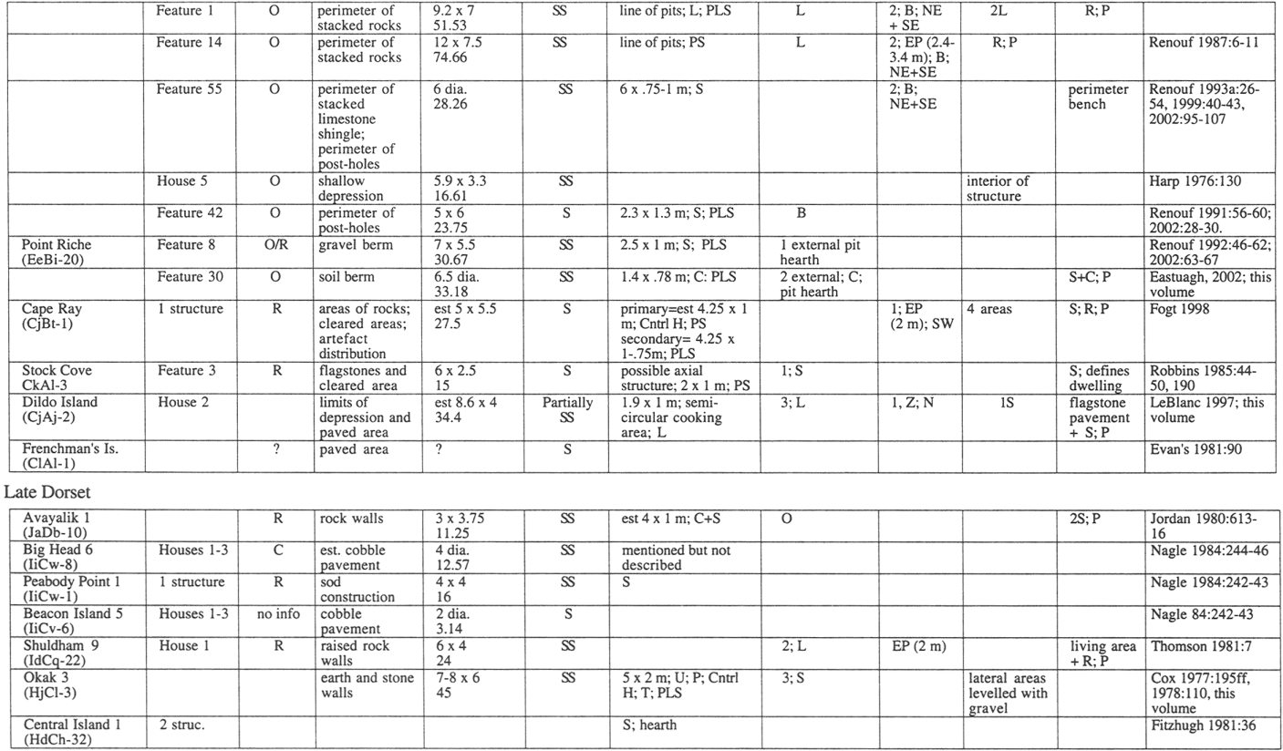
Middle Dorset
Middle Dorset sites are well-represented in the province, extending from northernmost to southern Labrador (Stopp 1997) and found throughout almost the entire coastal area of Newfoundland. Dwelling structures are found on sites in Avayalik (Jordan 1980), Saglek Bay (Thomson 1981; Tuck 1975), Okak (Cox, this volume), Nain (Fitzhugh 1976; Nagle 1984), Sandwich Bay (Wolff 2003), and in Newfoundland on the Northern Peninsula (Eastaugh 2002, this volume; Harp 1964, 1976; Hartery and Rast 2001, this volume; Renouf 1986, 1987, 1991, 1992, 1993a, 1993b; 2002), southwest coast (Fogt 1998), and Trinity Bay (Evans 1981; LeBlanc 1997, 1998, this volume; Robbins 1985).
Avayalik and Saglek
In northernmost Labrador, Middle Dorset structures are reported from two sites on Avayalik Island, Avayalik 2 (JaDb-1) and Avayalik 7 (JaDb-18). In Saglek Bay a Middle Dorset dwelling structure is described from Band 1, Rose Island, Site Q (IdCr-6) and at Shuldham 9 (IaCq-22).
Avayalik 2 and 7: The Avayalik sites lie on a narrow point forming a sheltered cove on Avayalik Island. At Avayalik 2 a bipod photograph clearly showed a sub-rectangular or bilobate boulder outline around a cobble and slab axial feature; Jordan (1980: 611) noted the absence of any internal divisions or box hearths. At Avayalik 7 Jordan described a circular to sub-rectangular boulder outline which he interpreted as a deflated dwelling structure. He described a 3-4 m entrance passage and a possible axial feature (Jordan 1980: 609); unfortunately there were no maps or photographs. Both sites were attributed to Middle Dorset on the basis of artefacts and radiocarbon dates. Avayalik 2 was dated to between 2240 ± 80 B.P. (SI 3889) and 1345 ± 70 B.P. (SI 3888) and a single date, 1395 ± 70 B.P. (SI 3890) came from Avayalik 7 (CAA Radiocarbon Database 2001).
Band 1, Rose Island, Site Q: Rose Island, Site Q is situated on a small west-facing 17.5 m terrace on Rose Island in Saglek Bay. The band was identified as Middle Dorset on the basis of characteristic artefacts and a date of 1780 ± 90 B.P. (I 5533). Tuck (1975: 64) described a number of small rocks and boulders in an otherwise sandy matrix and although he thought them unpatterned, an axial feature with slabs and apparent upright rocks can be seen in the site plan (Tuck 1975: 207).
Shuldham 9: Shuldham 9 is near the southwest corner of Shuldham Island in Saglek Bay. The site is located on a 4 m terrace, and there is evidence of Middle Dorset, Late Dorset and Thule occupation, the last possibly having disturbed the earlier occupations. One Middle Dorset dwelling, House 2, was described as roughly circular, with a slab-paved axial feature bordered on each site by a row of blocks (Thomson 1981: 10-11). Four dates pertain to this dwelling, ranging from 1200 ± 80 B.P. (SI 3354) to 470 ± 120 B.P. (Beta 9437) (CAA Radiocarbon Database 2001). Thomson described two platforms to the side of the axial feature, although he didn't specify if they were cleared or paved areas. He described each as having a cooking area, although he did not specify their construction. The structure was attributed to Middle Dorset based on artefacts, although some Late Dorset items were also found. There were no maps or photographs.
Okak
A Middle Dorset dwelling structure is reported from a single site in Okak, Iglusuaktalialuk 4 West (HhCj-5).
Iglusuaktalialuk 4 West: Iglusuaktalialuk 4 West is on the east side of Iglusuaktalialuk Island. Cox (1977, this volume) described a semi-subterranean rectangular dwelling with a 3 m entrance passage pointing away from shore. Two dates from this structure were 1860 ± 90 B.P. (SI 2508) and 1685 ± 70 B.P. (SI 2157) (CAA Radiocarbon Database 2001). There was a slab-paved axial feature bounded on one side by a row of upright slabs. Centrally placed within the axial feature was a box hearth with a slab bottom, and a paved area was to the rear of the axial feature. Cleared areas at each side of the axial feature were interpreted as sitting/sleeping areas. The dwelling walls were clearly defined on the basis of a soil change (Cox 1977: 137-138, this volume).
Nain
In Nain, Middle Dorset structures are found at Koliktalik 1 (HdCg-2), St. John Island 3, L-3 (HeCf-1) and Black Island 1A (HeCi-16).
Koliktalik 1: Koliktalik 1 is located on the 23 m terrace on Koliktalik Island and was defined as Middle Dorset on the basis of artefacts and two dates, 1720 ± 80 B.P. (SI 2150) and 1335 ± 90 B.P. (SI 2152) (Fitzhugh 1976: 130). According to the description and site plan, the main structure, House 1, was rectangular, semi-subterranean, with an entrance passage and a rear alcove. Fitzhugh (1976: 130) described a series of buried floors that consisted of peat lenses and fill that indicated as many as 15 re-floorings. A linear area of flat slabs in the central part of the dwelling suggested an axial feature. A second structure, House 2, was briefly described as similar to but smaller than House 1, but there were no details or site map.
St. John Island 3, L-4: This site is on a small rocky outer island not far from Koliktalik 1. Nagle (1984: 228) described an oval surface structure defined by a perimeter of stones and bisected by a linear pavement of flat slabs. There were two cleared lateral areas. He identified the structure as Middle Dorset based on a date from the axial feature of 1555 ± 90 B.P. (SI 2980). A date of 1910 ± 100 B.P. (Beta 1327) came from an adjacent exterior midden (Nagle 1984: 228).
Black Island 1A: This site is on the northern tip of Black Island (Nagle 1984: 230). One structure was described as an irregular ring of small boulders with slabs scattered in the interior. It was identified as Middle Dorset, based on characteristic artefacts (Nagle 1984: 231).
Sandwich Bay
A single site with a Middle Dorset dwelling structure was reported from this region, Snack Cove West 1 (FkBe-5).
Snack Cove West 1: This site is on a small 8 m cobble beach on a small island at the mouth of Sandwich Bay (Wolff 2003). A single dwelling structure was identified as Palaeoeskimo on the basis of fine-grained cherts and was thought likely to be Middle Dorset. The dwelling was defined by distinct cobble walls 50-100 cm high and in places 1 m wide. There was a 2 m entrance passage. Flat stones lay across the middle of the structure's interior, suggesting a disturbed axial feature, and some slabs within it suggested a collapsed box hearth. One side of the bisected interior was paved with cobbles, forming a platform. An excellent map was provided.
Northern Peninsula of Newfoundland
On the Northern Peninsula of Newfoundland, Middle Dorset structures are found at three sites, Peat Garden North (EgBf-18), Phillip's Garden (EeBi-1) and Point Riche (EeBi-20).
Peat Garden North: Peat Garden North is in a sheltered area in Bird Cove. The site was identified as Middle Dorset on the basis of a characteristic tool assemblage (Hartery and Rast 2001) and one radiocarbon date of 1570 ± 60 B.P. (Beta 113160); three other dates were anomalously recent, between 1030 ± 290 B.P. (TO 9555) and 677 ± 45 B.P. (BGS 2321) (Hartery and Rast, this volume). Two structures were found, one of which was fully excavated. This dwelling was described as oval, defined by a perimeter of beach cobbles stacked directly on the beach surface, raising the perimeter above the interior where beach cobbles had been removed by the original builders. A central area of raised cobbles was interpreted as an axial feature. This dwelling structure was shown in plan maps (Hartery and Rast, this volume) and its interior definition was mirrored in artefact distribution.
Phillip's Garden: Phillip's Garden is located on the Point Riche Peninsula, Port au Choix. It is the largest and best known Middle Dorset site in Newfoundland, with more than 60 dwelling depressions visible on two 6-11 m terraces. The site was defined as Middle Dorset based on artefacts and 28 radiocarbon dates ranging between 2140 ± 100 B.P. (Beta 23976) and 1370 ± 90 B.P. (Beta 66436). Harp excavated seven dwelling structures fully and tested another 13 (Harp 1964, 1976); Renouf fully excavated four structures (Renouf 1986, 1987, 1991, 1993a, 2002). Site substrate is limestone shingle over sand. For most dwelling structures at the site the shingle was removed from what was to become the central area, which was then dug 20-30 cm to form a depression. The depression was surrounded by two side platforms and/or a rear platform which were often raised and levelled, either by flat stones, cobbles or the removal of stones, and which often had pits in them. In one case there was a perimeter platform or bench. In most structures a line of pits served as the axial feature and there was at least one example of a slab axial feature. Where entrances could be inferred, most faced northeast towards the sea and were paired with a second entrance to the southeast (Figure 4). In one case there was an entrance passage. In at least some of the dwellings there were short pieces of cut whale rib, which may have served as structural elements.
Of the many dwelling structures at Phillip's Garden, House 2 (Harp 1976; Renouf and Murray 1999), Feature 1 (Renouf 1986; Renouf and Murray 1999), Feature 14 (Renouf 1987, 1991, 2002), Feature 55 (Renouf 1993a, 1999, 2002), House 5 (Harp 1976) and Feature 42 (Renouf 1991, 2002) were reported in greatest detail. In Table 3, the dwelling area (m2) was taken as the structure's footprint since it is difficult to assess whether the 1-2 m wide perimeter of stacked shingle was a wall or a platform.
House 2 and its associated midden was dated to between 1736 ± 48 B.P. (P 692) (Harp 1976) and 1640 ± 70 B.P. (Beta 160975) (Hodgetts 2002). Harp's map (1976: 133) showed the structure as a square depression with a raised platform attached at the rear. He described raised side walls constructed of limestone shingle and evidence of banked sod (Harp 1976: 132). The axial feature was a row of deep stone-lined pits that ran centrally through the dwelling and in the platform there were two pits, both in line with the axial feature (Harp 1976; Renouf and Murray 1999).
Feature 1 was dated to 1850 ± 100 B.P. (Beta 15379) (Renouf 1986; Renouf and Murray 1999). It was a smaller and less formalized structure than House 2, roughly oval in shape with an axial feature consisting of two stone-lined and bone-filled pits and two upright rocks interpreted as lamp supports. There were two lateral areas cleared of rock, interpreted as platforms, and there was a raised rear area paved with fist-sized cobbles, also interpreted as a platform. The perimeter was defined by a 1 m wide area of stacked limestone shingle (Renouf and Murray 1999: 123-124). A break in the northeast and southeast of this perimeter was interpreted as a primary and secondary entrance, respectively (Figure 4).
Figure 4
Plan of Features 1 and 14, Phillip's Garden, drafted by Edward Eastaugh. The top view shows Feature 1 (left) and Feature 14 (right) at the basal cultural level, with interpretive lines showing walls, platforms, and entrances. The bottom view is a contour map at 10, 15, and 30 cm intervals which supports the original interpretive lines and shows breaks in the shingle perimeter which are interpreted as entrances.

Feature 14 was adjacent to and slightly overlapped with Feature 1. It dated to 1970 ± 60 B.P. (Beta 23977) (Renouf 1987). It was an oval depression defined by a 1 m wide perimeter of raised limestone shingle. A narrow linear depression indicated a 3 m entrance passage facing southeast, away from the shore, and a slight break in the wall to the northeast suggested a secondary entrance. A cleared rear area was raised slightly above the main depression and was interpreted as a rear platform. Two stone-lined and bone-filled pits bisected the central depression (Renouf 1987).
Feature 55 dated between 1480 ± 40 B.P. (Beta 160976) (Hodgetts 2002: 35) and 1370 ± 90 B.P. (Beta 66436) (Renouf 1993a: 55, 2002: 116). This was a circular structure defined by a perimeter of limestone shingle and bisected by a limestone slab axial feature. There were two entrances, defined by breaks in the perimeter. The primary entrance was to the northeast and a secondary entrance was to the southeast. This was the only structure at Phillip's Garden where excavators removed the basal layers of rocks, to reveal a series of 12 large, deep, stone-lined post-holes in the sand substrate. These post-holes discontinuously ringed the outer rim of the shingle perimeter, indicating that this was a bench, not a wall. The post-holes were either straight or slanted inwards, suggesting that whale ribs were used in a frame that converged towards the centre (Renouf 1993a: 53, 1999: 40-42, 2002: 99). Based on the position and slant of the post-holes a reconstruction was made which suggested that the whale ribs formed the lower frame which was closed over with driftwood, forming a yurt-like structure (Renouf 1999: 43). In addition to the ring of post-holes were three sets of two smaller post-holes set at right angles to the ring, at 12 o'clock, 3 o'clock and 6 o'clock, suggesting small porches.
While semi-subterranean structures characterized Phillip's Garden, two shallow or surface structures were investigated. House 5 was dated to 1502 ± 49 B.P. (P 676) and was described by Harp as an oval shallow depression cleared of rocks. There was no built-up perimeter of shingle, no interior features and few artefacts (Harp 1976: 130-131). On this basis Harp suggested that this was a summer dwelling.
Feature 42, although undated, was attributed to Middle Dorset on the basis of associated artefacts. This was a well-defined axial structure surrounded by three small post-holes that were identified in the field, and 12 pits or small depressions that were identified in post-field analysis and interpreted as additional post-holes (Figure 5). The axial feature was composed of two large limestone slabs levelled on a bed of pea gravel; the slabs faced each other and a third large slab lay to the south, as if displaced. Between the two central slabs was a 75 cm wide space levelled with pea gravel around which was a number of small slabs which, set upright, could have formed a box hearth or lamp support (Renouf 1991: 57, 2002: 28-30). It was originally thought that the axial feature had been sheltered by a wind-break outlined by the three post-holes observed in the field (Renouf 1991: 58). However, if the interpretation of the pits and small depressions noted in post-field analysis are correct, the axial feature lay within an oval dwelling; I am indebted to Edward Eastaugh for these observations. Few artefacts were associated with Feature 42 and this, along with the nature of the structure itself, suggested that it was a warm-weather or short-term structure (Renouf 2002: 30).
Figure 5
Plan of Feature 42, Phillip's Garden (drafted by Edward Eastaugh)

Point Riche: The Point Riche site is 4 km southwest of Phillip's Garden, on the Point Riche headland. There were several dwelling depressions visible on the surface of the ground, 10-15 of which were confirmed as dwelling structures by site testing (Renouf 1987) and geophysical survey (Eastaugh 2001, 2002). Three of these were excavated (Renouf 1986, 1992; Eastaugh 2002, this volume), although one of them (Feature 1) was reinterpreted by Eastaugh (2002: 88ff) as a midden deposit rather than a dwelling structure. The site was identified as Middle Dorset based on artefacts and eight radiocarbon dates ranging between 1830 ± 90 B.P. (Beta 50024) and 1546 ± 80 B.P. (Beta 15377).
The two excavated dwelling structures were Features 8 and 30. Three dates from Feature 8 ranged between 1830 ± 90 B.P. (Beta 50024) and 1750 ± 90 B.P. (Beta 15382) (Renouf 1992: 102, 2002: 63-67). Feature 8 was a natural depression in the gravel substrate, about two-thirds of which was ringed by a built-up 1-2 m wide gravel berm. There was no berm on the side of the dwelling that faced the ocean but rather a broad level area; since there were concentrations of artefacts and debitage found, it was interpreted as a working area. There were no internal features but outside the structure was a linear concentration of slabs which was interpreted as an exterior axial feature. There was also a pit hearth to the rear of the structure. A piece of whale rib, 1.2 m x 20 cm, was found in the central area of the dwelling and might have been part of the structure's frame.
A single date from Feature 30 was 1546 ± 80 B.P. (Beta 15377) (Eastaugh 2002: 73, this volume). Feature 30 was constructed similarly to Feature 8, except that the central area was dug into the substrate and the built-up perimeter was of earth rather than gravel. In one area within the structure there was a concentration of cobbles and flat rocks that suggested a platform. There was a linear concentration of cobbles in the centre of the dwelling, suggesting an axial feature, and two external hearths.
Southwest Coast
There is one Middle Dorset dwelling in this region, from the Cape Ray site (CjBt-1).
Cape Ray: On the southwest coast of Newfoundland a structure is reported from the Cape Ray site (Fogt 1998). This is a large site located on an exposed point of land where bog is interrupted by dry knolls. It is defined as Middle Dorset based on artefact assemblage and four dates ranging from 2370 ± 85 B.P. (GX 1199) and 1380 ± 95 B.P. (GX 1907) (CAA Radiocarbon Database 2001). Although Linnamae (1975) did not identify dwelling structures at this site, a return visit by Fogt (1998) identified at least one. Fogt (1998: 63ff) described this dwelling as situated between two large bedrock boulders on a small knoll. An adjacent midden deposit occurred in the lower boggy area. The dwelling was defined on the basis of large rocks and slabs in conjunction with cleared areas. A series of detailed maps showed a rectangular area of rocks enclosing a relatively cleared area, except for two axial features that consisted of slabs and high concentrations of schist, soapstone, and burned stone. The axial features were at right angles to each other, intersecting in the centre of the dwelling, and they were interpreted as contemporaneous, one primary and the other secondary (Fogt 1998: 24). The central area of the primary axial feature was interpreted as the main hearth area based on a concentration of soapstone shatter, flakes, charcoal and burned rock. A second concentration of soapstone and burned rock occurred at one end of the primary axial feature, suggesting a second hearth area. The intersection of the two axial features divided the interior space into four roughly equal cleared quadrants. All but one were level, and the quadrant at the very edge of the knoll was on a slope. Fogt (1998: 25) interpreted this as an entrance that slanted upwards into the dwelling and possibly functioning as a cold trap passage. To the rear of the structure was a concentration of flat rocks forming a level area, which had been achieved by digging beneath the slabs (Fogt 1998: 27). Fogt interpreted this as a rear platform used in conjunction with the cleared level areas.
Trinity Bay
In Trinity Bay, structures are reported from three Middle Dorset sites, Stock Cove (CkAl-3), Dildo Island (CjAj-2) and Frenchman's Island (ClAl-1).
Stock Cove: Stock Cove is at the head of Trinity Bay, on the eastern shore of the Isthmus of Avalon. It is a multi-component site, and Middle Dorset occupation was identified on the basis of artefacts and three radiocarbon dates ranging between 1560 ± 60 B.P. (Beta 4064) and 1280 ± 60 B.P. (Beta 4062). An oblong flagstone pavement was identified as a possible dwelling (Robbins 1985: 190). There were two cleared areas on either side of what might be interpreted as an axial feature, and a hearth was located near the edge of the pavement. A midden abutted the seaward side of the structure and a single re-fit between the hearth and midden suggested contemporaneity (Robbins 1985: 49).
Dildo Island: Dildo Island is at the head of Trinity Bay. In sheltered Barry's Cove the remains of two Middle Dorset dwellings were excavated (LeBlanc 1997, 1998, this volume). These were identified as Dorset on the basis of artefacts and a series of 17 radiocarbon dates ranging from 1975 ± 40 B.P. (BSG 2235) to 1410 ± 70 B.P. (BETA 116906) (LeBlanc, this volume). House 1 was a surface feature which was not fully excavated and which was described as having an axial feature with three hearths (LeBlanc 1997: 11). LeBlanc excavated a large area of House 2 and described it in detail (LeBlanc 1998, this volume). It was a partially semi-subterranean structure defined by a long narrow carefully-fitted flagstone pavement, at each end of which was a fat-encrusted rock, or lamp support. To one side of the pavement was a semi-circular structure comprised of slanted slabs and horizontal basal slabs. This structure was filled with small fat-encrusted pebbles on which was a flat slab, or lamp support, with the blubber-stained outline of a rectangular soapstone vessel. LeBlanc called this a cooking area, or it could be considered a variety of axial feature. On the other side of the cooking area axial feature were flat slabs and rocks which LeBlanc interpreted as a platform. At the one end of the pavement was a large midden.
Frenchman's Island: Frenchman's Island lies at the head of Trinity Bay and has a Recent Indian and Middle Dorset component, each identified on the basis of artefacts and radiocarbon dates; the single Middle Dorset date is anomalously young, at 805 ± 70 B.P. (CAA Radiocarbon Database 2001; no lab number available). Evans (1981: 90) excavated a small area within which there was a linear pattern of flat stones associated with Middle Dorset artefacts. While this is likely to be some kind of structure, possibly a dwelling, not enough was excavated to speculate further.
Summary
Nine Middle Dorset structures in Labrador are reported in detail (Table 3). They are similar in size to the previous Groswater and Labrador Early Dorset structures, and range from 9.62 to 33 m2 with a mean of 20.26 m2. Four structures are rectangular or rectangular/oval and four are oval. Five structures are surface and three semi-subterranean. Five structures are defined by perimeter boulders, one by a soil change, and one by well-defined walls. Axial features are described for seven of the dwellings. Most are of slab construction, in two cases they include upright slabs, and in one case the axial feature is a line of pits. The entrance passages appear (N=4).
Thirteen Middle Dorset structures from Newfoundland are described in detail. Some of these are considerably larger than Labrador Middle Dorset structures and the size range is 15-74.66 m2 with a mean of 34.61 m2. Structures are oval (N=8) or rectangular (N=3) and most are semi-subterranean (N=8), rather than surface (N=5). Newfoundland Middle Dorset dwellings are characterized by their variability in construction. Walls are defined by stacked beach rock or shingle (N=5), a gravel or soil berm (N=2), and perimeter post-holes (N=1). In other cases the structure is defined less by wall areas than by paved (N=2) or cleared (N=2) interior areas. Axial features (N=11) are also variable, defined by cobble and slab pavement (N=7), a semi-circular cooking area (N=1) and a line of pits (N=3). In Cape Ray, two slab axial features were at right angles to each other and at Point Riche, one slab axial feature was external to the dwelling. Axial features lack vertical elements, there are rear or side platforms of slab and cobble construction (N=6) and at Phillip's Garden there is one example of a perimeter platform. Lamp supports where present are variable, consisting of paired upright rocks (N=2) or a fat-stained rock (N=1). At Phillip's Garden entrances are discernable as breaks in the wall area and there are paired primary and secondary entrances (N=3). At Phillip's Garden and Cape Ray there are examples of entrance passages (N=2).
Late Dorset
Northern Labrador
Late Dorset sites with dwelling structures are known in Avayalik (Jordan 1980), Seven Islands Bay (Nagle 1984), Saglek (Thomson 1981), Okak (Cox 1977, this volume) and Nain (Fitzhugh 1981).
Avayalik
In this region there is one Late Dorset site with a dwelling structure, Avayalik 1 (JaDb-10).
Avayalik 1: At this site a small, semi-subterranean, rectangular structure was found within which was a cobble and slab axial structure without hearth or lamp supports. A bipod photograph showed this axial feature clearly (Jordan 1980: 614). Gravel and rock areas occurred to each side and were interpreted as sleeping platforms. Jordan described the walls as composed of layers of rocks and sod and noted a superstructure of driftwood covered with sod and/or hides; the evidence for this was unclear. The structure was attributed to Late Dorset based on artefacts and a radiocarbon date of 670 ± 60 B.P. (SI 3864). The dwelling appeared to have been built into an earlier Middle Dorset midden and mid-passage structure (Jordan 1980: 616).
Seven Islands Bay
There are three sites with Late Dorset structures reported from Seven Islands Bay, Peabody Point (IiCw-1), Big Head 6 (IiCw-8) and Beacon Island 5 (IiCv-6).
Peabody Point 1: Peabody Point 1 is near the mouth of of Komaktorvik fjord (Nagle 1984: 242). One sub-rectangular, semi-subterranean dwelling was described, of sod construction and with an interior axial pavement. It was identified as Late Dorset based on characteristic artefacts, although two dates from the dwelling interior were somewhat early: 1315 ± 95 B.P. (SI 3372) and 1335 ± 70 B.P. (SI 3869); a third date was modern (Nagle 1984: 243).
Big Head 6: Big Head 6, not far from Peabody Point 1, contained three semi-circular, semi-subterranean structures which were described by Nagle (1984: 244-45) as axial hearth structures. These structures were dug into Early Dorset and Middle Dorset contexts and were identified as Late Dorset on the basis of artefacts types and a date from the interior of House 1, 1225 ± 65 B.P. (SI 3894).
Beacon Island 5: Beacon Island 5 is on a small island in the centre of Seven Islands Bay (Nagle 1984: 246). Nagle described three cobble pavements which he attributed to Late Dorset on the basis of material culture and a date on seal fat of 1160 ± 60 B.P. (SI 3373) which he modified to 730 ± 60 B.P., using Arundale's (1981: 225) correction factor for marine-based radiocarbon dates.
Saglek Bay
Shuldham 9 (IdCq-22) is the only site known from this region with a Late Dorset dwelling structure.
Shuldham 9: At Shuldham 9 Thomson (1981) found a Late Dorset structure (House 1) in addition to the Middle Dorset structure (House 2) described above. House 1 was a deep, sub-rectangular depression with a raised and partially paved rear area, interpreted as a platform. Six dates ranged from 640 ± 50 B.P. (Beta 3816) to 130 ± 60 B.P. (Beta 2408) (CAA Radiocarbon Database 2001). The living floor was paved with small slabs and there was a 2 m entrance passage. Within the structure on either side of the entrance was a grease-stained notched rock, interpreted as a lamp support (Thomson 1981: 7). Strips of baleen were found on the floor and in the entrance passage. Identification of this dwelling as Late Dorset was based on associated artefacts. Two excellent photographs are provided but no plan maps.
Okak
Okak 3 (HjCl-3) is the only site in this region with a Late Dorset dwelling structure.
Okak 3: At Okak 3 a Late Dorset dwelling (Cox 1977: 195ff, 1978: 110, this volume) was described as a semi-subterranean rectangular structure with earth-and-stone walls. The well-defined axial feature consisted of two parallel rows of upright boundary rocks, between which and outside of which were flat paving stones. Beyond that were two areas of pea gravel with levelled lateral platforms. Three hearths occurred within the axial structure, two in the central area and a third at one end. Lamp supports were associated with the three hearths, consisting of an upright notched slab and a burned and fat encrusted basal slab. The dwelling was identified as Late Dorset on the basis of two radiocarbon dates, 1005 ± 95 B.P. (SI 2154) and 895 ± 85 B.P. (SI 2506) (Cox, this volume).
Nain
Central Island 1 (HdCh-32) is the single site from this region with Late Dorset structures.
Central Island 1: Fitzhugh (1981) briefly described two Late Dorset axial pavements on Central Island 1 which he identified as Late Dorset on the basis of characteristic tools (Fitzhugh 1981: 36) and a date of 685 ± 60 B.P. (SI 4828). He noted that each axial feature had a single slab hearth feature.
Summary
There are eight Late Dorset dwellings described in detail in the literature, all from Labrador. These are large (11-45 m2), rectangular, semi-subterranean structures, with rock or earth and stone walls (N=3). Five structures have slab and/or cobble axial features and one of these includes vertical elements. Two dwellings have interior platforms and a third has cleared lateral areas levelled with pea gravel. There is one example of an entrance passage.
Discussion
A number of general patterns can be drawn from Tables 1-3. In Labrador, small, oval surface structures defined by perimeter rocks persist through all cultural periods, and in Early Dorset times rectangular semi-subterranean structures appear. Axial features are common through all periods, and include both a well-defined version with vertical elements and a less well-defined slab and cobble version with horizontal elements only. Interior pavements are in use from Groswater times onward. Box hearths and lamp supports are found in Pre-Dorset and Groswater contexts, after which box hearths disappear, as if supplanted by soapstone lamps and cooking vessels. Dwelling size increases from Early Dorset onward.
Newfoundland has an abbreviated Palaeoeskimo cultural sequence, with Groswater and Middle Dorset sites only. During both periods oval surface structures defined by perimeter cobbles are common as are rectangular semi-subterranean structures. Axial features occur in both Groswater and Middle Dorset contexts but are poorly delineated. Box hearths are uncommon and lamp supports occur in some Middle Dorset dwellings. Interior pavements and raised platforms are found only in Middle Dorset contexts. Wall construction is highly variable during both periods, and there is a marked increase in dwelling size during Middle Dorset.
Dwelling size, shape and ground preparation (e.g., surface excavation) are fundamental to other construction attributes. McQuire and Schiffer (1983), Diehl (1997), Binford (1990) and Smith (2003) connect shape and ground preparation to hunter-gatherer mobility, premised on an inverse relationship between the costs of initial construction and subsequent maintenance. They argue that the assessment of where to invest labour and materials depends on a structure's anticipated longevity since maintenance costs are an issue only when a dwelling is used over the long term. In turn, anticipated longevity relates to mobility, with less mobile hunter-gatherers using a dwelling longer or on a more regular basis. According to this reasoning, one would expect more highly mobile groups to construct low cost dwellings and less mobile groups to invest in more substantial structures.
As part of their analysis, McQuire and Schiffer (1983: 284-285) contrast the costs and benefits of domes and rectangular dwellings. Domes are a quick and low cost way to construct a dwelling since they are easy to put up and require less surface material per volume. However, construction materials must be flexible to accommodate the curves, which means that they are perishable and require more maintenance over the long term. Although the shape is wind resistant and the interior space easy to heat, the shape has size limitations and the interior space at the sides is not easily useable because of low headroom.
In contrast, a rectangular structure takes longer to build, uses more material per surface volume, is less resistant to wind and is harder to heat. However, there is no size restriction during or after construction, the corners are useful for storage, and the layout is conducive to interior partitioning. McGuire and Schiffer conclude that circular/oval dwellings are more appropriate for more highly mobile hunter-gatherers, while rectangular structures make more sense for less mobile groups. While Inuit multi-partitioned communal snow houses defy this comparison, being domed, expandable and internally partitioned (Dawson 2002), outside the use of this extremely plastic material, these generalizations about domed and rectangular dwellings seem logical.
They are empirically born out in Binford's (1990) examination of hunter-gatherer architectural design world-wide. Binford found that more highly mobile hunter-gatherers favoured semi-circular dwellings in contrast to semi-sedentary and sedentary hunter-gatherers who favoured rectangular dwellings. He also noted that less mobile groups tended to invest more time in ground preparation, constructing semi-subterranean dwellings, in contrast to the more mobile groups who used surface structures.
These construction details are relevant to Palaeoeskimo dwellings in Newfoundland and Labrador, indicating differences in residential mobility. Figure 6 shows the numbers of oval and rectangular dwellings and Figure 7 shows the numbers of surface and semi-subterranean dwellings. Both figures show the same trend of an increase over time in architectural attributes that indicate decreased mobility. Figure 6 shows that oval dwellings were in common use through all cultural periods in Newfoundland and Labrador and that rectangular dwellings were most common during Dorset times. Similarly, Figure 7 shows that surface structures were in common use through all cultural periods and that semi-subterranean structures were most common in Dorset contexts. This suggests that in both areas Dorset Palaeoeskimos were less mobile than earlier populations.
This is further substantiated by dwelling size which increases over time. Figure 8 shows Newfoundland and Labrador Palaeoeskimo dwelling size in m2. The boxes represent the central trend in the data expressed as the middle two quartiles and the lines represent the outer two quartiles. In both regions, Dorset dwelling size is larger than in earlier periods, particularly in Newfoundland where the increase is substantial. Presuming that dwelling size reflects the number of occupants, this indicates an increase in household size during the Dorset period. Increased group size is linked to decreased mobility since a larger group is disadvantageous under highly mobile conditions, particularly in northern areas where residential moves tend to be over long distances (Binford 1980; Kelly 1995). The decreased mobility of Dorset populations in Newfoundland and Labrador, reflected in these dwelling details, is consistent with more general observations made about Dorset throughout the eastern Arctic (Fitzhugh 2002; McGhee 1996; Maxwell 1984).
Figure 6
Relative frequencies of oval and rectangular dwellings

Figure 7
Relative frequencies of surface and semi-subterranean dwellings

Figure 8
Relative dwelling sizes in m2

Table 1
Summary of Pre-Dorset dwelling structure attributes

1. Shape: B=bilobate; O=oval/circular; R=rectangular/sub-rectangular
2. Size: dia=diameter; est=estimated from plan map
3. Surface characteristics: S=surface; SS=semi-subterranean
4. Axial feature: U=upright slabs; S=flat slabs; C=cobbles; T=terminal rocks; P=associated paving; Ctrl H=central hearth; TH=terminal heart towards or at the end of axial feature; L=lamp support; W=wings; PS=perpendicular to shoreline; PLS=parallel to shoreline; OS=oblique to shore
5. Hearth: #=number; C=cobble; S=slab; B=box hearth; L=lamp support; Z=other
6. Entrance: #=number; B=break in perimeter; EP=entrance passage; Z=other; N,S,E,W, etc=cardinal directions
7. Cleared areas: 1S=one side; 2S=two sides; P=possible platform
8. Paved areas: C=cobble; S=slab; 1S=one side; 2S=two side; R=rear; P=possible platform
Table 2
Summary of Groswater Palaeoeskimo dwelling structure attributes

(See Table 1 for footnotes)
Table 3
Summary of Dorset dwelling structure attributes
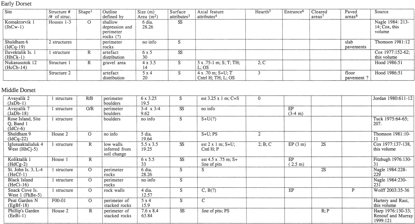
Table 3 (suite)
(See Table 1 for footnotes)
Parties annexes
Acknowledgements
I would like to thank the following funders who have supported my research: SSHRC, Parks Canada, Memorial University of Newfoundland, the Provincial Archaeology Office, and the Canada Research Chairs Program. Edward Eastaugh digitized dwelling plans and contour maps shown from Phillip's Garden and contributed to the interpretations of Phillip's Garden and Point Riche dwelling structures. Patty Wells helped with figures and data, and David Mercer drafted the site location map. Thanks to Steve Cox, Bill Fitzhugh and Elaine Anton for generously providing me with unpublished information. Thanks also to Steve Hull of the Provincial Archaeology Office for providing me with information from the PAO site database. I appreciate the helpful comments of two anonymous reviewers. Finally, a special thanks to Sylvie LeBlanc and Murielle Nagy for inviting me to St-Pierre to participate in an exciting workshop.
Note
-
[1]
Unless otherwise stated, all radiocarbon dates in this paper are charcoal-based and are expressed in radiocarbon years before present (B.P.).
References
- ANTON, Elaine, 2003 St. John's Harbour 5 (HeCi-30) and an Examination of Groswater and Early Dorset Relationships in Labrador, M.A. thesis, St. John's, Memorial University of Newfoundland, Department of Anthropology.
- ARUNDALE, Wendy H., 1981 Radiocarbon dating in eastern arctic prehistory: A flexible approach, American Antiquity, 46(2): 244-271.
- AUGER, Reginald, 1984 Factory Cove: Recognition and Definition of the Early Palaeo-eskimo Period in Newfoundland, M.A. thesis, St. John's, Memorial University of Newfoundland, Department of Anthropology.
- BINFORD, Lewis, R., 1980 Willow smoke and dogs' tails, American Antiquity, 45(1): 4-20.
- BINFORD, Lewis, R., 1990 Mobility, housing and environment: A comparative study, Journal of Anthropological Research, 46(2): 119-152.
- CAA RADIOCARBON DATABASE, 2001 Compiled by Richard Morlan, Hull, Canadian Museum of Civilization, http://www.canadianarchaeology.com localc14.
- COX, Stephen L., 1977 Prehistoric Settlement and Culture Change at Okak, Labrador, unpublished Ph.D. dissertation, Cambridge, Massachusetts, Harvard University, Department of Anthropology.
- COX, Stephen L., 1978 Palaeo-eskimo occupations of the north Labrador coast, Arctic Anthropology, 15(2): 96-118.
- COX, Stephen L., 1988 Pre-Dorset occupations of Okak Bay, Labrador, The Northern Raven, 7(3): 1-3.
- DAWSON, Peter, 2002 Space syntax analysis of Central Inuit snow houses, Journal of Anthropological Archaeology, 21: 464-480.
- DIEHL, Michael W., 1997 Changes in Architecture and Land Use Strategies in the American Southwest, Journal of Field Archaeology, 24: 179-194.
- EASTAUGH, Edward, 2001 Report on the 2001 Field Season at Point Riche, Port au Choix National Historic Site, unpublished report on file, Halifax, Parks Canada, Atlantic Region, Archaeology.
- EASTAUGH, Edward, 2002 Intra-site Variability at the Dorset site of Point Riche, Port au Choix, M.A. thesis, St. John's, Memorial University of Newfoundland, Department of Anthropology.
- EVANS, Clifford, 1981 1980 Field report of Frenchman's Island Project, in Jane Sproull Thomson and Bernard Ransom (eds), Archaeology in Newfoundland and Labrador 1980, Annual Report, 1: 88-94.
- FITZHUGH, William W., 1972 Environmental archaeology and cultural systems in Hamilton Inlet, Labrador, Washington, Smithsonian Institution, Smithsonian Contributions to Anthropology, 16.
- FITZHUGH, William W., 1976 Preliminary culture history of Nain, Labrador: Smithsonian fieldwork 1975, Journal of Field Archaeology, 3: 123-142.
- FITZHUGH, William W., 1980 Preliminary Report on the Torngat Archaeological Project, Arctic, 33(3): 585-606.
- FITZHUGH, William W., 1981 Smithsonian archaeological surveys, central and northern Labrador, 1980, in J. Sproull Thomson and Bernard Ransom (eds), Archaeology in Newfoundland and Labrador 1980, Annual Report, 1: 26-47.
- FITZHUGH, William W., 2002 Nukasusutok 2 and the Paleoeskimo transition in Labrador, in William Fitzhugh, Stephen Loring and Daniel Odess (eds), Honoring our Elders: a history of eastern Arctic archaeology, Washington, Arctic Studies Center: 133-162.
- FOGT, Lisa M., 1998 The excavation and analysis of a Dorset Palaeoeskimo dwelling at Cape Ray, M.A. thesis, St. John's. Memorial University of Newfoundland, Department of Anthropology.
- GRØN, Ole, Ericka ENGLESTAD and Inge LINDBLOM (eds), 1991 Social Space: human spatial behaviour in dwellings and settlements, Odense, Denmark, Odense University Press.
- GRØNNOW, Bjarne and Jens Fog JENSEN, 2003 The Northernmost Ruins of the Globe: Eigil Knuth's Archaeological Investigations in Peary Land and Adjacent Areas of High Arctic Greenland, Meddelelser om Grønland, Man and Society, 29.
- HARP, Elmer, 1964 The Cultural Affinities of the Newfoundland Dorset Eskimo, Ottawa, National Museum of Canada Bulletin, 200.
- HARP, Elmer, 1976 Dorset settlement patterns in Newfoundland and southeastern Hudson Bay, in Moreau S. Maxwell (ed.), Eastern arctic prehistory: Palaeoeskimo problems, Washington, Memoirs of the Society for American Archaeology, 31: 119-138.
- HARTERY, Latonia and Timothy RAST, 2001 Bird Cove Archaeology Project 2000 field season: Final report, unpublished report on file, St. John's, Government of Newfoundland and Labrador, Department of Tourism, Culture, and Recreation, Provincial Archaeology Office.
- HODGETTS, Lisa M., 2002 Report of the 2001 excavations at Phillip's Garden, Port au Choix National Historic Site, unpublished report on file, Halifax, Parks Canada, Atlantic Region, Archaeology.
- HOOD, Bryan, 1986 Nukasusutok-12: Early/Middle Dorset Axial Structures from the Nain Region, Labrador, Palaeo-Eskimo Cultures in Newfoundland, Labrador and Ungava, St. John's, Memorial University of Newfoundland, Reports in Archaeology, 1: 49-64.
- JENSEN, Jens Fog, 1993 Intrasite analysis of Palaeo-eskimo campsites, M.A. thesis, Copenhagen, University of Copenhagen, Department of Archaeology.
- JORDAN, Richard, 1980 Preliminary results from archaeological invetigations on Avayalik Island, extreme northern Labrador, Arctic, 33(3): 607-627.
- KELLY, Robert L., 1995 The foraging spectrum, Washington and London, Smithsonian Institution Press
- KENT, Susan (ed.), 1990 Domestic architectures and the use of space, Cambridge, Cambridge University Press.
- KNUTH, Eigil, 1966-67 The ruins of musk-ox way, Folk, 8-9: 191-219.
- LeBLANC, Sylvie, 1997 Dildo Island archaeological project: The Dorset occupation of Dildo Island preliminary field report, 1996, unpublished report on file, St. John's, Government of Newfoundland and Labrador, Department of Tourism, Culture, and Recreation, Provincial Archaeology Office.
- LeBLANC, Sylvie, 1998 Dildo Island 1997 field season interim report, unpublished report on file, St. John's, Government of Newfoundland and Labrador, Department of Tourism, Culture, and Recreation, Provincial Archaeology Office.
- LINNAMAE, Urve, 1975 The Dorset culture: a comparative study in Newfoundland and the Arctic, St. John's, Newfoundland Museum, Technical Papers of the Newfoundland Museum, 1.
- LORING, Stephen, 1983 An archaeological survey of the inner bay region between Nain and Davis Inlet, Labrador: A report of 1992 field work, in Jane Sproull Thomson and Callum Thomson (eds), Archaeology in Newfoundland and Labrador 1982, St. John's, Government of Newfoundland and Labrador, Department of Tourism, Culture, and Recreation, Historic Resources Division, Annual Report, 3: 32-56.
- LORING, Stephen and Steven COX, 1986 The Postville Pentecostal Groswater Site, Kaipokok Bay, Labrador, in Palaeo-Eskimo Cultures in Newfoundland, Labrador and Ungava, St. John's, Memorial University of Newfoundland, Reports in Archaeology, 1: 65-94.
- MAUSS, Marcel and Henri BEUCHAT, 1979 Seasonal variations of the Eskimo: A study in social morphology, London, Routledge and Kegan Paul. (Originally published in 1906 as Essai sur les variations saisonnières des sociétés eskimos, L'Année sociologique, 9ième année, 1904-05: 39-132.)
- MAXWELL, Moreau, S., 1985 Eastern Arctic Prehistory, New York, Academic Press.
- McGHEE, Robert J., 1996 Ancient people of the Arctic, Vancouver, UBC Press.
- MCGUIRE, Randall H. and Michael B. SCHIFFER, 1983 A theory of architectural design, Journal of Anthropological Archaeology, 2: 227-303.
- NAGLE, Christopher L., 1984 Lithic raw material procurement and exchange in Dorset culture along the Labrador Coast, Ph.D. dissertation, Waltham, Brandeis University, Department of Anthropology.
- ODGAARD, Ulla, 2001 Palaeo-eskimoic shamanism, North Atlantic Studies, 4(1-2): 25-30.
- PARK, Robert, 1988 "Winter houses" and qarmat in Thule and historic Inuit settlement patterns: some implications for Thule studies, Canadian Journal of Archaeology, (12): 163-176.
- READER, David, 1997 Archaeological excavations at Parke's Beach, Bay of Islands, 1996: Groswater and Dorset Palaeoeskimo and Beothuk components, unpublished report on file, St. John's, Government of Newfoundland and Labrador, Department of Tourism, Culture, and Recreation, Provincial Archaeology Office.
- READER, David, 1998 Archaeological excavations at Parke's Beach (DgBm-1), 1997: Groswater Palaeoeskimo House 1 and Beothuk House 1, unpublished report on file, St. John's, Government of Newfoundland and Labrador, Department of Tourism, Culture, and Recreation, Provincial Archaeology Office.
- RENOUF, M.A. Priscilla, 1986 Report of 1985 excavations at the Point Riche and Phillip's Garden sites, Port au Choix National Historic Park, unpublished report on file, Halifax, Parks Canada, Atlantic Region, Archaeology.
- RENOUF, M.A. Priscilla, 1987 Archaeological excavations at the Port au Choix National Historic Park: report of 1986 field activities, unpublished report on file, Halifax, Parks Canada, Atlantic Region, Archaeology.
- RENOUF, M.A. Priscilla, 1991 Archaeological investigations at the Port au Choix National Historic Park: report of the 1990 field season, unpublished report on file, Halifax, Parks Canada, Atlantic Region, Archaeology.
- RENOUF, M.A. Priscilla, 1992 The 1991 archaeological field season at the Port au Choix National Historic Park, unpublished report on file, Halifax, Parks Canada, Atlantic Region, Archaeology.
- RENOUF, M.A. Priscilla, 1993a The 1992 archaeological field season, Port au Choix National Historic Park: report of archaeological excavations, unpublished report on file, Halifax, Parks Canada, Atlantic Region, Archaeology.
- RENOUF, M.A. Priscilla, 1993b Palaeoeskimo seal hunters at Port au Choix, northwestern Newfoundland, Newfoundland Studies, 9(2): 185-212.
- RENOUF, M.A. Priscilla, 1994 Two transitional sites at Port au Choix, northwestern Newfoundland, in David Morrison and Jean-Luc Pilon (eds), Threads of Arctic Prehistory: papers in honour of William E. Taylor, Jr., Hull, Canadian Museum of Civilization, Archaeological Survey of Canada, Mercury Series, 149: 165-196.
- RENOUF, M.A. Priscilla, 1999 Ancient cultures, bountiful seas: The story of Port au Choix, St. John's, Historic Sites Association of Newfoundland and Labrador.
- RENOUF, M.A. Priscilla, 2002 Archaeology at Port au Choix: 1990-1992 excavations, St. John's, Copetown Press, Occasional Papers in Northeastern Archaeology, 12.
- RENOUF, M.A. Priscilla and Maribeth S. MURRAY, 1999 Two winter dwellings at Phillip's Garden, a Dorset site in northwestern Newfoundland, Arctic Anthropology, 36(1-2): 118-132.
- ROBBINS, Douglas R., 1985 Stock Cove Trinity Bay: the Dorset Eskimo occupation of Newfoundland from a southeastern perspective, M.A. thesis, St. John's, Memorial University of Newfoundland, Department of Anthropology.
- SMITH, Craig, S., 2003 Hunter-gatherer mobility, storage, and houses in a marginal environment: an example from the mid-Holocene of Wyoming, Journal of Anthropological Archaeology, 22(2): 162-189.
- STOPP, Marianne P., 1997 Long-term coastal occupancy between Cape Charles and Trunmore Bay, Labrador, Arctic, 50(2): 119-137.
- TANNER, Adrian, 1979 Bringing home animals: Religious ideology and mode of production among Misstassini Cree hunters, St. John's, Memorial University of Newfoundland, Institute of Social and Economic Research, Social and Economic Studies, 23.
- TANNER, Adrian, 1991 Spatial organization in social formation and symbolic action: Fijian and Canadian examples, in Ole Grøn, Ericka Engelstad and Inge Lindblom (eds), Social space: human spatial behaviour in dwellings and settlements, Odense, Odense University Press: 21-39.
- THOMSON, Callum, 1981 Preliminary archaeological findings from Shuldham Island, Labrador, 1980, in Jane Sproull Thomson and Bernard Ransom (eds), Archaeology in Newfoundland and Labrador 1980, St. John's, Government of Newfoundland and Labrador, Department of Tourism, Culture, and Recreation, Historic Resources Division, Annual Report, 1: 5-25.
- TUCK, James A., 1975 Prehistory of Saglek Bay, Labrador: Archaic and Palaeo-Eskimo ocupations, Ottawa, National Museum of Man, Archaeological Survey of Canada, Mercury Series, 32.
- TUCK, James A., 1978 Excavations at Cow Head, Newfoundland: An interim report, Études/Inuit/Studies, 2(1): 138-141.
- WOLFF, Christopher B., 2003 Middle Dorset in Southern Labrador: an examination of three small sites in the Porcupine Strand region, M.A. thesis, St. John's, Memorial University of Newfoundland, Department of Anthropology.
- YATES, Timothy, 1989 Habitus and social space: some suggestions about meaning in the Saami (Lapp) tent ca. 1700-1900, in Ian Hodder (ed.), The meaning of things, London, Unwin Hyman: 249-262.
Liste des figures
Figure 1
Location of sites mentioned in the text
Figure 2
Plan of Pre-Dorset structure at Sipukat Bay (redrawn from Cox 1977: 231)
Figure 3
Plan of Structure 1, Postville Pentecostal site (redrawn from Loring and Cox 1986: 84)
Figure 4
Plan of Features 1 and 14, Phillip's Garden, drafted by Edward Eastaugh. The top view shows Feature 1 (left) and Feature 14 (right) at the basal cultural level, with interpretive lines showing walls, platforms, and entrances. The bottom view is a contour map at 10, 15, and 30 cm intervals which supports the original interpretive lines and shows breaks in the shingle perimeter which are interpreted as entrances.
Figure 5
Plan of Feature 42, Phillip's Garden (drafted by Edward Eastaugh)
Figure 6
Relative frequencies of oval and rectangular dwellings
Figure 7
Relative frequencies of surface and semi-subterranean dwellings
Figure 8
Relative dwelling sizes in m2
Liste des tableaux
Table 1
Summary of Pre-Dorset dwelling structure attributes
1. Shape: B=bilobate; O=oval/circular; R=rectangular/sub-rectangular
2. Size: dia=diameter; est=estimated from plan map
3. Surface characteristics: S=surface; SS=semi-subterranean
4. Axial feature: U=upright slabs; S=flat slabs; C=cobbles; T=terminal rocks; P=associated paving; Ctrl H=central hearth; TH=terminal heart towards or at the end of axial feature; L=lamp support; W=wings; PS=perpendicular to shoreline; PLS=parallel to shoreline; OS=oblique to shore
5. Hearth: #=number; C=cobble; S=slab; B=box hearth; L=lamp support; Z=other
6. Entrance: #=number; B=break in perimeter; EP=entrance passage; Z=other; N,S,E,W, etc=cardinal directions
7. Cleared areas: 1S=one side; 2S=two sides; P=possible platform
8. Paved areas: C=cobble; S=slab; 1S=one side; 2S=two side; R=rear; P=possible platform
Table 2
Summary of Groswater Palaeoeskimo dwelling structure attributes
(See Table 1 for footnotes)
Table 3
Summary of Dorset dwelling structure attributes
Table 3 (suite)
(See Table 1 for footnotes)