Résumés
Abstract
Ugiuvak, or King Island, off the coast of the Seward Peninsula in the Bering Strait, is among the few Arctic villages with stilt houses in an environment where wood is essentially lacking. In 1899, Edward W. Nelson, describing the island’s architecture, noted that wood was abundant. Today, the contrast is striking between the bareness and steepness of the coast and the extensive use of wood in the village. This article presents information about wood procurement and use as building material on Ugiuvak in the last 300 years based on literature review, on-site observations, and discussions with members of the King Island community. It briefly reviews the origin, circulation, and deposition of driftwood in the Bering Strait region. It then explores the possibility of a relationship in the 19th century between an increase in driftwood availability and the development of stilt architecture on the island, taking into account other wood sources that became available at the time. The last 150 years of occupation of the village were marked by a transition from a solely driftwood-based economy to one where driftwood was first supplemented and then largely replaced by lumber.
Résumé
Ugiuvak, ou île de King, au large du littoral de la péninsule Seward dans le détroit de Béring, fait partie des quelques rares villages arctiques à avoir des maisons sur pilotis dans un environnement où le bois est essentiellement absent. En 1899, Edward W. Nelson, dans sa description de l’architecture de l’île, observe que le bois y est abondant. Aujourd’hui, le contraste est frappant entre l’aspect dénudé des côtes abruptes et l’utilisation abondante du bois dans le village. Cet article présente des informations sur l’acquisition et l’utilisation du bois comme matériau de construction à Ugiuvak au cours des 300 dernières années sur la base de ce qui existe dans la littérature, d’observations faites sur l’île et de discussions avec des membres de la communauté de l’île de King. Il comprend un bref exposé sur l’origine, la circulation et le dépôt des bois flottés dans le détroit de Béring. Il explore ensuite la possibilité d’un lien entre une plus grande disponibilité du bois flotté au XIXe siècle et le développement de l’architecture sur pilotis dans l’île, tout en tenant compte des autres sources de bois qui deviennent disponibles à cette époque. Les derniers 150 ans d’occupation du village sont marqués par le passage d’une économie essentiellement fondée sur le bois flotté à une économie où le bois flotté a d’abord été complété par des bois commerciaux avant que ces derniers ne deviennent la première source d’approvisionnement.
Corps de l’article
Introduction
Like many coastal communities of Arctic North America, the inhabitants of King Island, or Ugiuvangmiut, were great wood users. Locally called Ugiuvak (‘place for winter’), King Island is a small and steep rocky island in the Bering Strait some 60 km west of Cape Woolley (Singigak) on the Seward Peninsula (Figure 1). In the now-deserted village, wood was used to build houses and to make many utensils, weapons, and boats. This multiplicity of wood uses contrasts greatly with the island’s apparent bareness, its absence of trees, and its paucity of driftwood. By documenting how King Islanders used wood, where they found it, and how far away they went to collect it, we can better understand the historical development of their settlements. Elder Ted Mayac, who was born and raised on the island, stated: “Wood was, for us, one of the most sought out creations of nature” (March 2006, Annual Meeting of the Alaska Anthropological Association). For the Ugiuvangmiut, their subsistence depended on procuring wood and transforming it into usable structures and implements.
The National Science Foundation-funded project “Documenting the Cultural Geography, Biogeography, and Traditional Ecological Knowledge of King Island, Alaska” led by Deanna Kingston and the King Island community provided an opportunity to address questions about wood use, provenance, and procurement, and how these aspects had changed over time. The 2005 field season included efforts to record information about driftwood occurrence, deposition, and use on King Island and in the vicinity of Cape Woolley (Figure 1). Described as “the point on the mainland on which the skin boats from King Island always make their first landfall” (Bogojavlensky 1969: 11), Cape Woolley has been a long-time hunting and fishing camp for King Islanders and was the project base camp.[1] The fieldwork also provided an opportunity to look at recent coastal depositions of driftwood just outside Norton Sound, as well as the impact of recent storms on previously deposited driftwood (see Mason 2006).
Historically, King Islanders collected some of their annual wood supply directly from the mainland. By 1967, almost everyone had relocated to Nome following the decision by the Bureau of Indian Affairs to close the school, which had been built in 1929. Consequently the village was deserted and only used by some individuals during the walrus-hunting season. In 2005, a few house structures were still standing while most had collapsed and a number of objects, mostly made of wood, could still be found underneath the house ruins or stored inside standing ones. As a part of the King Islanders’ cultural heritage, these historical remains contain a wealth of information about past wood use and the transition from a primarily driftwood-dependent economy to a lumber-dependent one. This article is about the availability of driftwood and lumber on the island, and their use as building materials. A greater abundance of driftwood in the Bering Strait in the 19th century, along with other timber sources, may have encouraged development of the stilt houses that would become icons of Bering Strait architecture.
Figure 1
Map of the Bering Strait region, Alaska, with locations mentioned in the text

Ugiuvak – King Island
The information related here is from observations recorded during a short field season from July 9 to 22, 2005: five full days on King Island and the remaining time at Cape Woolley. In both places, while participating in project research and training, I recorded the presence of driftwood on the lagoon, following a methodology established previously (Alix 2004, 2005). No systematic sampling was undertaken. Technical and cultural knowledge was also recorded through casual discussions and work sessions with members of the King Island community, mainly Ted Mayac, Francis Alvanna, Sylvester Ayek, Alex and Gabriel Muktoyuk, Celia and Edward Muktoyuk, and Lucy Koyuk. Furthermore, much of the short time spent on the island was used to record and measure some of the structures still standing or lying in ruins.
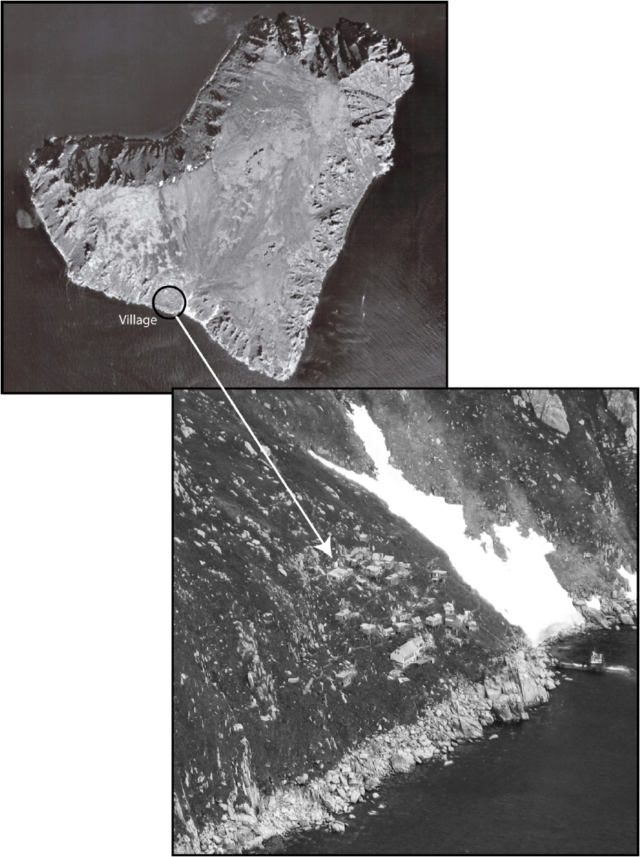
King Island is a fascinating place for anthropologists and archaeologists, and has been so for travellers and explorers ever since they first described it, i.e., at least since the early 18th century (Kingston 2000, 2009). We still do not fully know when a group of people decided to first settle this challenging place. The Ugiuvangmiut are indeed among the few Inuit groups known to have lived on such an abrupt land surface (Figure 2). Other Bering Strait communities lived on sloping ground but none as steep as that of Ugiuvak. For example, Little and Big Diomede islands are topographically similar, but both have at least one area of shoal waters and patches of rocky shore that are wide enough for establishment of a village. The village of Little Diomede was established on a 5 degree slope at most, whereas King Island’s inhabitants literally lived on a 45 to 30˚ slope (Jenness 1929: 82; Giddings 1941: 45; Hopkins and Chapman 1966: 7; Renner 1979: 96). According to many reports and to the King Islanders themselves, the abundance of game (especially walruses) and thus the prospect of never going hungry compensated for the hardship of living on the island (e.g., Hawkes 1914a). The ecology of the Bering Strait is such that the Inupiat of the Diomedes, King Island, the village of Wales on the Alaska mainland, and the Siberian Yupiit of St. Lawrence Island were similar in relying on the plentiful sea mammals, such as walrus and whales (Ellanna 1983). The defensive location of the steep slope was probably a further incentive to settlement (Jenness 1929; Mason 2009). Indeed, there is a saying among King Islanders that the island shielded itself from the view of outsiders.
Two other villages are said to have existed on the slopes around King Island, and a “cave with old ivories” has been reported (Bogojavlensky 1969: 31; Ellanna 1983: 181; Seeganna 1988: 26; Muñoz 2007: 20, 107). According to the memories of elders in the 1960s and 1970s, the island supported more than one village at some point in the past until the smallpox epidemic of 1836-1839[2] (Bogojavlensky 1969: 31; Ellanna 1983: 181-183). While this denser occupation remains to be documented and dated, Muñoz (2007:107) reports finding a blue bead at one of the old villages, an indication of post-contact occupation. Unlike Little Diomede Island, where anthropologist Diamond Jenness (1929) found the presence of early first millennium AD Old Bering Sea occupations (Morrison 1991), no such artifacts have been found on King Island. During the 2005 and 2006 archaeological survey of the present project, however, Matt Ganley and Ted Mayac located an early occupation near the summit of the island, which is dated to nearly a thousand years ago, ca. 1040-1260 (Ganley 2006; Mason 2009: 95; O’Leary 2007: 132). The site appears to be four distinct stone features with no discernible entranceways. A 50-cm test pit has yielded fragments of pottery, charcoals, and burnt blubber but no diagnostic artifacts (Ganley 2006). Unlike the deserted village, this early occupation is located on the flat summit of the island, which is exposed to intense winds (Hopkins and Chapman 1966). By comparison, the slope is more sheltered and better suited for settlement. One must also keep in mind that winter land-fast ice extended the base of the slope by creating a horizontal surface that was completely gone in the summer, thus making the slope less appealing for human habitation from July to September (Senungetuk and Tiulana 1987: 14).
Figure 2
Aerial photo of King Island (courtesy of U.S. Geological Survey) and view of the village from the helicopter in June 2005
King Island is rich in food resources but poor in wood. The island is covered with tundra vegetation that includes small vascular plants (lichens, flowering plants, and herbs), a few rare and small woody plants such as cloudberry bushes (Rubus chamaemorus) and “at least ten different edible species” (Bogojavlensky 1969: 10). The steep slopes prevent large amounts of driftwood from being washed up on the island’s shores. It is possible that more wood was available when King Islanders first settled the Island. On the other hand, the motivation to occupy the island was probably so great that access to wood was not a priority.
Driftwood availability on King Island
The driftwood found in Norton Sound, on the Bering Strait islands, and north along the shores of the Seward Peninsula comes mainly from the Yukon River drainage basin, which is Alaska’s largest wood-producing basin (Giddings 1941). Although major sources also include some minor rivers like the Koyuk, which directly empties into Norton Sound and is bordered by spruce trees all the way to the coast (Giddings 1947), the volume of driftwood these smaller rivers carry is hardly comparable to that of the Yukon, which is broad and fast-flowing. Drift logs collected on King Island in 1939 apparently originated along the Yukon River in the Yukon Flats as well as near the tree line, most probably on the lower Yukon (Giddings 1941: Table 2).
Today, the island’s topography prevents most driftwood from being stranded on its shores. In the lifetime of present-day King Islanders, driftwood has never been really abundant around the island. According to Gabriel Muktoyuk, the occasional driftwood logs and stumps seen in July 2005 entrapped in the rocks were typical of what he had ever remembered finding: a few pieces randomly distributed among rocks with no specific stranding places. Indeed, most shores around the island drop steeply into the sea. Part of the northwest shore, however, is slightly less steep with rocks coming down more smoothly, and this location is precisely where we found driftwood. Elders in 2005 mentioned the former presence of a beach on the northwest side of the island, before their time (see also Mason 2006: 54). It may have been a driftwood catchment area in the past.
Sylvester Ayek recalled that driftwood came to King Island once in a great while, when the wind was blowing from the mainland. During interview sessions at Cape Woolley, several elders mentioned a time when driftwood came in great quantity to the island’s shores: “There was a time […]. Great-grandparents’ time or great-great-grandparents’ time, when people could walk on top of the driftwood in front of the village […] they could walk two miles out to get the good ones […] they walked on it like at a lumberyard.”
Walking on driftwood is an image often used by subarctic or Arctic residents to describe an unusual abundance of driftwood due, for example, on the Yukon or the Mackenzie, to an exceptional spring ice breakup (Alix 2005: 93; Kindle 1921: 53). While probably an overstatement, the above saying suggests that exceptional arrivals of driftwood occurred in the past, perhaps during specific time periods, and that varying amounts could reach the island. In the late 19th century, Edward W. Nelson visited King Island and observed that “Driftwood was abundant there but the principal material for covering the house was broken granite” (Nelson 1899: 255). Nelson did not specify whether driftwood was abundant as house-building material or as material lying on the island’s rocky shores. He seemed to imply, however, that driftwood was not plentiful enough for use as material to cover house structures, as he had described for villages like St. Michael, Cape Nome, or even Wales, all on the Alaska mainland (Nelson 1899: 241-258).
There is most likely a correlation between colder temperatures, more frequent flooding, increased storminess, and increased driftwood delivery (Mason 1998). When high winter precipitation and cold spring temperatures in the interior of Alaska are followed by rapid warming, the sudden breakup of ice creates ice jams and flooding and large numbers of logs will be carried downriver and into the ocean (Alix 2005). For example, the 2009 winter and spring conditions on the Yukon River—heavy winter snowfall, above-normal ice thickness, cold April temperatures, and sudden and rapid rise of temperature starting April 25—resulted in a once-in-a-century flood on the upper and mid-Yukon that tremendously increased the amount of wood transported downriver (Alix 2009; Corral 2009). At the other end, sea circulation and coastal delivery of driftwood is determined by several factors, including summer and fall storms (Mason 1998, 2006). In fact, as pointed out by VanStone (1977: 82, note 5), A.F. Kashevarov, who travelled along the northwest coast of Alaska in 1838, was among the first explorers to appreciate the importance of driftwood to Arctic populations and the role of summer (and fall) storms in its coastal delivery.
Nineteenth-century reports about the Bering and Chukchi seas describe cold temperatures, thick sea ice, and frequent storms during the later part of the century, with some storms being more intense than present-day ones (Hooper 1884 in Mason 2006; Kindle 1909: 182; VanStone 1977: 34, 46). These storms were frequent and intense, as indicated by the number of surge channels both on the Seward Peninsula and around Icy Cape (Owen Mason, pers. comm. 2012). Fall storms were also more frequently recorded from 1898 to 1914 in the Norton Sound area (Mason et al. 1996), this being perhaps the tail end of a period of increased storm intensity during the 19th century or at least the late 19th century. Tree-ring data from the Seward Peninsula region indicate cooler summer temperatures (May-Aug) during the 19th century (D’Arrigo et al. 2004), and Mason correlates this cooler weather with increased storminess. In the interior of Alaska, which ultimately controls the amount of driftwood transported downriver, the tree-ring record shows warmer summer temperatures during the 19th century, especially between 1834 and 1879 (Barber et al. 2003). At the same time, Mason and Beget (1991) suggest that lower mean annual temperatures and higher summer rainfall have resulted in more frequent flooding over the last 400 years. Incidentally, Nelson (1899: 248) reported that high water destroyed the winter village of Paimut (60 km upstream from the Russian Mission on the Yukon River) in the summer of 1879, thus forcing the inhabitants to spend the winter in their summer camp.
The above data suggest that conditions for driftwood “production,” transport, and coastal delivery were at a maximum during the 19th century, with extreme events on the Yukon River potentially providing surges of wood into the Arctic. It is worth noting that reports from that time present driftwood as seemingly more common in the region (Kindle 1909; Nelson 1899; VanStone 1977). When elders recollect an unusual presence of driftwood around the island, are they recalling one or more events? Were such events regular because overall climatic conditions were different, or are elders referring to one specific extreme event? Did increased storminess in the 19th century indeed lead to more driftwood being delivered into the Bering Strait and around King Island?
Wood procurement
The importance of wood (qiruk) to King Islanders is reflected in the rich terminology of wood types and expressions that they use in their Inupiaq dialect to talk about woodworking. Table 1 lists words recorded during conversations about wooden objects and wood-related activities with several project participants: David and Francis Alvanna, Gabriel and Edward Muktoyuk, and Ted Mayac. The list was further completed and checked for proper spelling with linguist Lawrence Kaplan, who is compiling a King Island Inupiaq dictionary and was a project participant as well. Some of the words confirmed information recorded about wood procurement or reflected external influences such as tusrkhaq (‘plank, board’), originally a Russian word. Others refer to wood types and parts, such as unaqsiwik, unaqsiq, mumiġnaq or ikkiq, that have distinct characteristics, the words being used for specific objects or components of objects and structures (bowls, umiaq, kayak, etc.). These driftwood types are mostly coniferous from the genus Picea (spruce). Similar wood categories are known in other Eskimo-Aleut languages, which show the same basic understanding of wood properties, similar selection procedures, and a common and profound knowledge of wood as a raw material (Alix 2007; Lemus-Lauzon et al. this issue; Walls this issue).
Table 1
King Island Inupiaq wood terminology recorded during conversations with David and Francis Alvanna, Gabriel and Edward Muktoyuk, and Ted Mayac. Completed and checked for spelling by Lawrence Kaplan (Alaska Native Language Center)

While lumber and planks, as the word tusrkhaq suggests, were probably traded by early Russian explorers and 19th-century whalers stopping at King Island on their way north, wooden tools, rather than the raw material itself, are more often reported as prime items when lists of trade goods are provided (Bockstoce 1986, 2009). In the first two decades of the 20th century, commercial lumber was brought to the island more systematically, and the period following 1940 “marked the beginning of large imports of lumber” (Bogojavlensky 1969: 39). Before the introduction of commercial wood, King Islanders had access only to driftwood and timber from the Alaska mainland and logs drifting by the island.
When based on the island, the Ugiuvangmiut literally caught the logs out at sea, directly from the water. This practice is felt to be too risky by the Yupiit of the Yukon-Kuskokwim delta, but it is described in East Greenland (Gessain 1984) and remembered in northern Alaska as well (Alix 2004). For the Bering Strait islands, Hawkes (1914b in Lee and Reinhardt 2003: 102) reports: “[…] the islanders are constantly on the lookout for the drifting timber, and put out to sea in the stormiest weather for a distant piece, be it large or small. They also patrol the coast after a high tide for stray bits of wood.” Similarly, Giddings (1941: 46) states that King Islanders watched for driftwood while watching for seals and waterfowl and took advantage of the high elevation of the island. King Islanders “ […] are able to estimate the value of logs farther out at sea than would be possible from a settlement at the water’s edge and tow them to shore behind their boats.” In 2005, Ted Mayac confirmed these previous observations:
Driftwood was so precious to our people that they’d go out with large skin boats to get wood that would pass by the island. It was a common occurrence […] in fact they had a way of telling the village […] if they’d seen something going by they would holler niaqunaaq! which refers to the root of the tree sticking out. This way they’d know wood was drifting by and that they better launch their boat to get it. You understood niaqunaaq meant wood passing by […].
Going after the logs was usually a collective activity. Ted Mayac recalled that the one who had seen and hollered niaqunaaq! would get the log, but the villagers were obliged to help him retrieve it from the water. Most of the time, the job was done with an umiaq, being often too much for one person alone to handle from a kayak.
Spruce driftwood and timber (Picea sp.) and shrub-like wood (alder [Alnus sp.] or willow [Salix spp.]) were collected during the summer months spent in Norton Sound and brought back by boat. Golovin Bay and nearby Rocky Point seem to have been areas where King Islanders acquired wood. They usually travelled there in the fall (Koutsky 1981; Ray 1975: 75; VanStone 1973: 80). Koutsky (1981: 43) mentions Suŋuraqtalik, a place where “[…] a landslide […] killed a number of King Islanders camped at the site.” King Islanders also collected wood at Cape Nome, in particular “willow” trees called nunaŋik that were used to make snowshoes. Ted Mayac recalled that “willows” were picked green and brought to the island with their bark on, and that women used the bark to dye sealskins. These “willows” may thus have been alders, especially Alnus sinuata, which are known for this property (Anderson 1939: 715; Nelson 1899: 117; see also Table 1). Brush is commonly referred to as “willows” even when the trees are alders or from another genus.
Bringing wood and logs back to the island became easier once King Islanders began to return in the fall by ship and not simply by umiaq. At first, they relied on the vessels of the U.S. Revenue Cutter Service, such as the Bear or the Corwin. After 1935, the ship North Star of the Bureau of Indian Affairs annually brought people back to their island for the winter with their umiaq and supplies (Renner 1979). Sometimes the ship would tow rafts of logs, an operation never done by umiaq. Rafting logs to King Island was considered too dangerous and the wood had to be placed inside the boat. If the weather was fair and the sea calm, it would take a whole night and a whole day to paddle across the 90 miles separating King Island from Nome[3] (Renner 1979: 75).
Carrying wood inside the skin boat limited the number of logs transported, or else multiplied the number of trips to and from the mainland. Thus, log size and weight were probably limited as well. As a result, it would take more than one year to collect enough material to build an umiaq (Bogojavlensky 1969: 64; Seeganna 1988: 19). Much of the wood must have therefore been brought to the island directly from the sea, from the shore, or from waters close to the island. Indeed, according to Bogojavlensky (1969: 70) “a man, with sufficient patience and luck, [could] accumulate enough of the right kinds of driftwood from the immediate vicinity of the island to construct a boat frame.” Although driftwood today rarely appears on or off the island’s shores, keeping a constant lookout and travelling to the mainland were sufficient to meet needs.
House building, wood selection, and the origin of stilts
In 2005, the village still had two main forms of structure with three types of function: stilt houses and underground buildings, including qagrit[4] (“club houses” or community houses) and caches. The last two types had since caved in. Some of the caches may have once been underground houses, this use having been completely discontinued around 1940 (Bogojavlensky 1969: 103). Most of the stilt houses had either completely collapsed or were in the process of collapsing, although a few were still standing and safe to enter. It was thus possible to record some technical characteristics of the island’s architecture.
The qagrit or “club houses”
These community houses were large underground structures that people entered through a tunnel. Men used them as workshops and the community as a place for social activities and dances (Seeganna 1988: 12-13). Together with umiaq crew teams, they were at the centre of the village’s social and political organisation, with community members belonging to different “club houses.” Men also used the qagrit for occasional sweat baths. Considering the scarcity of wood, providing enough firewood for that activity was a sign of wealth (Bogojavlensky 1969: 117).
The caved-in remains of three qagrit could still be seen in 2005. King Islanders remember them well and call them respectively Qaluitat, Aguliit, and Nutaat (Figure 3). All three are built to the same model with large cross-beams and upright planking of the walls. They are about 7 m wide with cross-beam logs regularly 30 cm in diameter, made of what looked like coniferous wood, most probably spruce (Figure 4). Because the cross-beams were large and, thus, heavy, they were likely collected directly from the sea near the island or towed by a ship in the fall, rather than transported in an umiaq. Unfortunately, given their already advanced stage of decay and precarious location, they could not be sampled for tree-ring analysis. All three qagrit had frames that incorporated bones (scapula, ribs, and other long bones) from large whales. In most cases, the bones were placed in the entrance area and at the corners of the structures.
Figure 3
Map of the village with locations of qagrit (names in italics) sketched from a photo by Matt Ganley (Vice President of Land and Resources at the Bering Straits Native Corporation and Co-Principal Investigator for the project). The houses were randomly numbered for structural assessment by Matt Ganley and the King Island Community. Bold italics indicate qagrit last in use

The Nutaatqagri appeared to be the most recent of the three structures. Its frame had the fewest drift logs and was the only one that had square lumber as beams. It had been completely renovated in 1943 and “blessed by Lafortune on the morning of 12 November and inaugurated with a banquet and dances that evening” (Renner 1979: 123). These three “club houses” had been used in the early 20th century, and two were still in use after 1950. Other qagrit existed either previously or at the same time as these three ones. Bogojavlenslky (1963: 31) reports the existence of at least six qagrit prior to the 1890 famine that reportedly killed two thirds of the population (see also Ellanna 1983: 181). In 2005, Ted Mayac provided information about three of these former qagrit as well as their locations in the village (Figure 3):
Near the avalanche area (underneath collapsed house 53), an old qagri was used by the Kuuηmiut (‘people of the Creek’). People stopped using it probably because it was too close to the avalanche area.
Slightly above and beyond the westernmost standing house of the village (above collapsed house 52) is where makkiuġviηmiut, the old shaman men’s house, was located. It ceased to be used before the missionaries’ time.
Underneath house 21, there used to be a small qagri called Qagriuraamiut that three families used. It was dismantled when the school was built because it stood in the way. Its “talisman” was a crab claw hung at the door.
Figure 4
Caved-in qagri with large beam supports (~30 cm in diameter) in 2005. Photo by Claire Alix
A
Aguliit

B
Qaluitat

Origin of the stilt houses
Stilt houses were first used in the summer and have been described many times (Hawkes 1914b; Lee and Reinhardt 2003; Nelson 1899; Seeganna 1988: 9-10). Nelson (1899: 255) vividly portrays the original stilt house with walrus-skin walls (Figure 5) and explains the general principle of house stabilisation.
The summer houses were remarkable structures; they were square inclosures, made wholly of tanned walrus hide, with a slightly arched roof of walrus skins drawn snugly over the wooden framework and lashed firmly in place. The houses were elevated and held in place by a framework, which consisted of two main poles standing upright with their bases fastened among the rocks and connected by a wooden crossbar lashed to them 10 or 20 feet [3 to 6 m] from the ground. From this crossbar other bars extended on a level back to the slope of the hill, where they were made fast. The floor was of roughly hewed planks, and at the back rested against the face of the hill.
Nelson 1899: 255
When reported in the late 19th century, these summer houses seem to have been relatively new and used mainly in the warmer months. According to Father Louis Renner (1979: 71), the stilt houses appeared “sometime during the second half of the 19th century.” When Ivan Kobelev visited King Island in June 1791, about a century before E.W. Nelson, he made no mention of them. Instead, he compared King Island dwellings to those of Big Diomede Island: semi-subterranean, made with a wooden frame, covered with sod and stone, and entered through an underground tunnel (Ray 1975: 54). The stilt houses required two raw materials: wood and walrus skins, procurement of which was limited by availability (driftwood) and access to wealth (walrus skins). Greater wood availability in the 19th century, as suggested above, may have favoured building of stilt houses, which were considered more comfortable and less damp in the warmer months than underground houses (Bogojavlensky 1969: 103; Lee and Reinhardt 2003: 88). These structures required many long wooden poles, probably more so than for semi-subterranean houses. They were photographed in the late 19th century, and these photographs show at least a dozen poles for a single structure, with a good number reaching 6-10 m (20-30 feet) in length (Figure 5). Stilt structures, mostly storehouses, were reported in the late 19th century in several villages of Norton Sound, but not all of them had walrus-skin walls (Nelson 1899: 243-244). Nelson described similar walrus-skin-wall stilt structures on Big Diomede Island but specified they were used as storehouses (ibid.: 256). According to Muir (1917), who visited Bering Strait in 1881, they were used as summer dwellings on Little Diomede Island. However, other researchers report that they were simply storage huts, like those on Big Diomede Island (Carol Jolles, pers. comm. 2006).
Another source of wood, long telegraph poles, became available in Norton Sound and hence Bering Strait after 1867, and they might have played a role in supporting the structure of the stilt houses. Bogojavlensky (1969: 24) reports that elders in 1969 “still had stories about the “telegraph men” and the wire and poles they left behind.” As they recalled, “the long poles were taken to King Island and used for framing the cliff-hanging dwellings” (ibid.). The Western Union Telegraph Company Expedition was a failed three-year endeavour in Alaska and Siberia (1865-1867) to lay the groundwork and start building an overland telegraph line that would have connected North America to Europe via Alaska, the Bering Strait and the Amur River (Bancroft 1890: 576; Dall 1897: 356-359). By the time the project was halted and all expedition members recalled, 80 km (50 miles) of telegraph lines had been installed in the Norton Sound region and about 45 km (30 miles) in the Port Clarence area. Posts and lines were thus “left […] to the mercy of the elements and the good will of the Indians” (Ennis 1954: 166 citing the Evening Bulletin of Oct. 1867). King Islanders traditionally visited both areas during their summer months on the mainland. The permafrost made it difficult for the Western Union Telegraph Expedition members to drive the posts into the ground and “by the fall of 1867 not a single pole stood erect” (Dall 1897: 358). The local inhabitants must have found it easy to recover and use them (see also Ennis 1954: 166).
Figure 5
Historical photo of King Island in 1888. Note the number of poles in each house, their straightness, and their uniformity. Courtesy of Alaska State Library, Mrs. Allen (Agnes Swineford) Shattuck Photograph Collection, P27-110

Interestingly, however, when Giddings (1941: Table 2) cross-dated the tree rings of 14 logs retrieved from King Island in the late 1930s, only one of them had a last year of growth corresponding to the time (1865-1867) when trees would have been cut down for use as telegraph poles. Because the logs he collected were 10 to 50 years older than that time period, the poles of the stilt houses probably had to be replaced regularly. Between the documented greater supply of driftwood during the 19th century and the telegraph poles of 1867, it is fair to say that the stilt houses originated during a period when wood resources were indeed more abundant or more easily accessible. This reality helps explain the context of E.W. Nelson’s observation.
Later stilt houses
Today, the remaining house structures show the transition from an economy based on driftwood to one based on lumber supplemented with driftwood. In fact, because of its geographical isolation and the King Islanders’ relocation to Nome some 50 years ago, the old village offers a unique look into this major but poorly documented transition. According to Father Renner (1979), 13 years after Father Lafortune’s first visit in 1916, King Islanders started to build a second type of square stilt house using commercial lumber and planks. These plank-wall stilt houses soon replaced the summer skin-wall houses and became lived-in year-round. Consequently, they replaced the winter underground houses, which for the most part became storage spaces and caches. This gradual shift took place between 1916 and 1929, the year when Lafortune visited the island for the second time (ibid.). However, historical photographs, such as those taken during the voyages of the U.S. Cutter Thetis in 1888 and 1889 (Wilson 2003: 42-45), already show the presence of plank-wall structures and indicate that King Islanders had started to build them occasionally before the end of the 19th century.
The shift to plank-wall stilt houses was strongly related to increased access to lumber from the mainland and to the possibility of regularly bringing wood cargo aboard ships, although we noticed in 2005 that a large number of driftwood stilts were still part of several house frames. Driftwood thus continued to be a major source of wood until the village was abandoned. We also noticed that the stilts were regular in their dimensions both on the old historical pictures and in the present-day ruins of the village. Among the standing and collapsed structures, stilt diameter ranged from 11 to 19 cm but was generally close to 15 cm. The dimensions were similar for the lumber and square posts used to build some of the later houses (or to replace old driftwood posts). Stilts were also repaired or strengthened by splices (Figure 6B) that look very similar to splices on traditional harpoon and arrow shafts and on other smaller pieces of equipment.
Some natural features of the wood, such as the stump or the forking off of branches, were reserved for specific uses. For example, right-angle curved stumps were used as bracers to support the front deck of the stilt house (Figure 6A). Similar bracers made of driftwood stumps have been reported along the Kuskokwim River in southwestern Alaska (Alix and Brewster 2004). Houses had wooden floors, which are amply described in the literature (Hawkes 1914a, 1914b; Nelson 1899), and these floors were preserved in some of the standing structures. Cut marks, indicating the use of metal tools, could still be seen on planks made from large coniferous logs—most probably spruce drift logs.
Figure 6
Stilts and specific use of wood in 2005. Photo by Claire Alix
A
Bracer

B
Splice
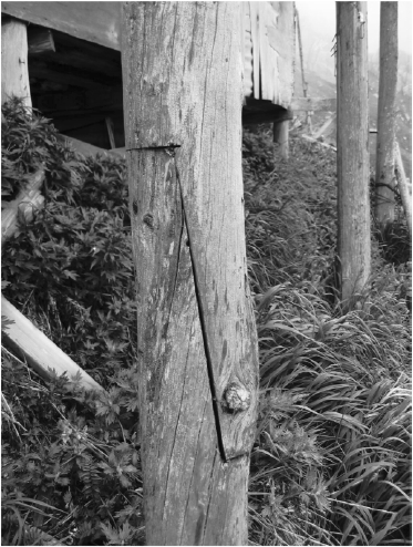
Figure 7
Entrance to main and side rooms of houses in 2005. Photo by Claire Alix
A
square entrance from the main entry room
B
Modified entry opening to side room

Originally, the rooms of a house were entered from an open vestibule and through small square openings in the wall (Figure 7A) “that people crawled through to enter the room” (Seeganna 1988: 9). The door was kept small to reduce heat leakage and wind infiltration. Over time, and probably under Western influence, these entrances were made taller to look more like doors (Figure 7B). A few houses retained the more traditional square openings, which prevented cold air from entering.
Conclusion
The history and origin of settlement on King Island is yet to be fully understood, but the project “Documenting the Cultural Geography, Biogeography and Traditional Ecological Knowledge of King Island, Alaska” has provided a great opportunity to advance this line of research. Historical documents and early accounts indicate that stilt architecture was a late development in what is now known to be at least a thousand years of occupation (Kingston 2009; Mason 2009). Oral history and climate data support the idea that stilt houses became widespread in response to an increase in driftwood logs appearing off the island during the 19th century, together with indirect wood sources created by early attempts at economic development in Alaska. While more research is certainly needed, it is clear that these stilt and walrus-skin-wall houses and later plank-wall houses were restricted to the Bering Strait region (Lee and Reinhardt 2003) and seem to have lasted no more than one to two centuries.
Early photographs show the stilt houses and skin-drying racks with their numerous poles, giving the impression that these structures hung from the cliff (Figure 4). This unique image, epitomised by King Island but shared by several Bering Strait communities, has been memorable ever since the first outsiders had set eyes on the island and met its inhabitants (e.g., Hawkes 1914a; Nelson 1899: 255). The various attributes of these stilts (size, age, origin of the poles, etc.) and what they can tell us about past technological traditions and developments are key to reconstructing past human occupation of the island. Through precise recording of such data, together with systematic tree-ring analysis, researchers may amass a large body of data that will help clarify some of the questions raised in this article. By understanding how wood was procured and used as part of a complex and informed technological system, we may better understand settlement and subsistence strategies as well as environmental and cultural change over time. Systematic analysis should be pursued.
Parties annexes
Acknowledgments
This article would have been impossible without the dedication and determination of Deanna Paniataaq Kingston and the many members of the King Island community who conceived and conducted the project “Documenting the Cultural Geography, Biogeography, and Traditional Ecological Knowledge of King Island, Alaska” funded by the National Science Foundation. My immense thanks go to all the members of the King Island community I met in 2005 when participating in the project. They patiently answered my questions and introduced me to their island and culture. I want to acknowledge specifically Teddy and Agnes Mayac, Gabriel and Frances Muktoyuk, Edward and Cecilia Multoyuk, Earl and Leonna Mayac, Francis Alvanna, Helen Pushruk, Marie Saclamana, Lucy Koyuk, Agatha Kukuluk, Agatha Ford, Becky Amarok, Bertha Herzner, Olga Kingston, Mary Dillard, Gertrude Analoak, Alex Muktoyuk, Lillian Tiulana, Vince Pikonganna, David Alvanna, Charlene Saclamana, Gregory Saclamana, James Pushruk, Susie Toliver, Caroline Brown, Ricky Seeganna, Walter Analoak, Sylvester Ayek, Martha Binford Wells, Sean Seeganna, Chad Pushruk, Pat Sagoonick, and many others who came to visit or stayed at Cape Woolley. My sincere thanks also go to Owen Mason (GeoArch Alaska) who got me involved in the project and without whom I would not have come to Alaska and would not have learned half of what I know today. I am also grateful to Lawrence Kaplan for his sense of collaboration and his comments and help with Inupiaq terminology and spelling. Matt Ganley was instrumental in carrying out the project and its logistics. Along with him, I would also like to thank Kim Nelson, Jon Butzke, TT Tahbone, Jeremiah and Cathleen Osborne-Gowey, Kai Henifin, and Jesse Ford. Finally, I am grateful to the constructive comments and advice from two anonymous reviewers that greatly improved the paper. All factual and interpretative errors are my own.
Notes
-
[1]
The project base camp was actually several km north of Cape Woolley, across the lagoon from the King Islanders’ fishing camp.
-
[2]
There is no direct evidence that the smallpox epidemic of the mid-1830s reached King Island. According to Ray (1975: 126-127) “[…] obviously the vaccination successfully halted the northward spread and there is no evidence that it went beyond Koyuk and Golovin” (see also Fortuine 1989: 230-236). However, King Islanders had close connections with the people of Golovin (Ray 1975: 75), and the disease may have been contracted by some during a visit there.
-
[3]
Nowadays, with an outboard engine, the trip still takes 13 hours with a full load (Alex Muktoyuk, pers. comm. July 2005).
-
[4]
Singular qagri.
References
- ALIX, Claire, 2004 Bois flotté et archéologie de l'Arctique: contribution à la préhistoire récente du détroit de Béring, Études/Inuit/Studies, 28(1): 109-131.
- ALIX, Claire, 2005 Deciphering the impact of change on the driftwood cycle: Contribution to the study of human use of wood in the Arctic, Global and Planetary Change, 47(2-4): 83-98.
- ALIX, Claire, 2007 Ethnoarchéologie de la production des objets en bois dans l’Arctique nord-américain, in Sylvie Beyries and Virginie Vaté (eds), Les civilisations du renne d’hier et d’aujourd’hui. Approches ethnohistoriques, archéologiques et anthropologiques, XXVIIe Rencontres Internationales d’Histoire et d’Archéologie d’Antibes, Antibes, Éditions APDCA: 377-391.
- ALIX, Claire, 2009 Wood at Cape Espenberg: Understanding Thule management of an unpredictable resource and the implications of exceptional wood "arrival" events for prehistoric analysis, paper presented at the 17th Annual Arctic Conference, November 13-14, Boulder (abstract online at: http://instaar.colorado.edu/ArcticConference/).
- ALIX, Claire and Karen BREWSTER, 2004 Not all Driftwood is Created Equal: Wood Use and Value along the Yukon and Kuskokwim Rivers, Alaska, Alaska Journal of Anthropology, 2(1): 48-65.
- ANDERSON, J.P., 1939 Plants Used by the Eskimo of the Northern Bering Sea and Arctic Regions of Alaska, American Journal of Botany, 26(9): 714-716.
- BANCROFT, Hubert H., 1890 History of Alaska, San Francisco, The History Company.
- BARBER, Valery A., JUDAY, Glenn P., FINNEY, Bruce P. and Martin WILMKING, 2003 Reconstruction of summer temperatures in Interior Alaska from tree-ring proxies: Evidence for changing synoptic climate regimes, Climatic Change, 63(1-2): 91-120.
- BOCKSTOCE, John R., 1986 Whales, ice, and men: the history of whaling in the western Arctic, Seattle, University of Washington Press, New Bedford, New Bedford Whaling Museum.
- BOCKSTOCE, John R., 2009 Furs and Frontiers in the Far North: The Contest among Native and Foreign Nations for the Bering Strait Fur Trade, New Haven, Yale University Press.
- BOGOJAVLENSKY, Sergei, 1969 Imaangmiut Eskimo careers: skinboats in Bering Strait, Ph.D. dissertation, Department of Social Relations, Harvard University, Cambridge.
- CORRAL Roy, 2009 Breakup conditions poised to make history, The Tundra Drums, May 07, 2009.
- DALL, William H., 1897 Alaska and its Resources, Boston, Lee and Shepard Publishers.
- D'ARRIGO, Rosanne, Erica MASHIG, David FRANK, Gordon JACOBY and Rob WILSON, 2004 Reconstructed warm season temperature for Nome, Seward Peninsula, Alaska. Geophysical Research Letters, 31 (online at: http://www.geos.ed.ac.uk/homes/rwilson6/Publications/DArrigoetal2004.pdf).
- ELLANNA, Linda J., 1983 Bering Strait insular Eskimo: a diachronic study of economy [i.e. ecology] and population structure, Juneau, Alaska Department of Fish and Game, Division of Subsistence, Technical paper, 77.
- ENNIS, William H., 1954 Journal of William H. Ennis, member, Russian-American Telegraph Exploring Expedition, San Francisco, California Historical Society Quarterly, 33(1-2).
- FORTUINE, Robert, 1989 Chills and Fever - Health and Disease in the Early History of Alaska, Fairbanks, University of Alaska Press.
- GANLEY, Matthew, 2006 A preliminary archaeological survey of King Island, paper presented at the 33rd Annual Meeting of the Alaska Anthropological Association, Kodiak (abstract available at http://www.alaskaanthropology.org/).
- GESSAIN, Robert, 1984 Dance masks of Ammassalik (East Coast of Greenland), Arctic Anthropology, 21(2): 81-107.
- GIDDINGS, James Louis, 1941 Dendrochronology of Northern Alaska, Tucson, University of Arizona, Laboratory of Tree-Ring Research, Laboratory of Tree-Ring Research Bulletin, 1.
- GIDDINGS, James Louis, 1947 The Forest Edge at Norton Bay, Alaska, Tree-Ring Bulletin, 13: 26-29.
- HAWKES, Edward W., 1914a The cliff dwellers of King Island, Wide World Magazine, 33(6): 81-91.
- HAWKES, Edward W., 1914b The dance festivals of the Alaskan Eskimo, University of Pennsylvania Anthropological Publications, 6(2): 3-41.
- HOOPER, Calvin L., 1884 Report of the cruise of the U. S. revenue steamer Thomas Corwin, in the Arctic Ocean, 1881, Washington, Government Printing Office.
- HOPKINS, David and R.M. CHAPMAN, 1966 Engineering geological problems on King Island, Alaska, Menlo Park, U.S. Geological Survey, Menlo Park, Technical Letter King Island, 1.
- JENNESS, Diamond, 1929 Little Diomede Island, Bering Strait, Geographical Reviews, 19(1): 78-86.
- KINDLE, Edward M., 1909 Notes on the Point Hope Spit, Alaska, The Journal of Geology, 17(2): 178-189.
- KINDLE, Edward M., 1921 Mackenzie River Driftwood, Geographical Review, 11: 50-53.
- KINGSTON, Deanna P., 2000 Siberian Songs and Siberian Kin: Indirect Assertions of King Islander Dominance in the Bering Strait Region, Arctic Anthropology, 37(2): 38-51.
- KINGSTON, Deanna P., 2009 "Almost Every Place, Every Rock had a Name": A consideration of place-name density on King Island, Alaska, AlterNative; An International Journal of Indigenous scholarship, 5(1): 7-25.
- KOUTSKY, Kathryn, 1981 Early days on Norton Sound and Bering Strait. An overview of Historic sites in the BSNC Region, Volume 4,The Nome, Fish River, and Golovin areas, Fairbanks, University of Alaska Fairbanks, Anthropology and Historic Preservation, Cooperative Park Studies Unit.
- LEE, Molly and Gregory A. REINHARDT, 2003 Eskimo architecture: dwelling and structure in the early historic period, Fairbanks, University of Alaska Press and University of Alaska Museum.
- MASON, Owen K., 1998 The Contest between the Ipiutak, Old Bering Sea, and Birnirk Polities and the Origin of Whaling during the First Millennium A.D. along Bering Strait, Journal of Anthropological Archaeology, 17(3): 240-325.
- MASON, Owen K., 2006 Landscape history of Woolley Lagoon and vicinity, Alaska: Implications for King Islanders living with a barrier island, final report to Oregon State University, in completion of year one of Geoarchaeology component, Anchorage.
- MASON, Owen K., 2009 Flight from the Bering Strait: Did Siberian Punuk/Thule Military Cadres Conquer Northwest Alaska? in H. Maschner, O.K. Mason and Robert McGhee (eds), The Northern Words, AD 900-1400, Salt Lake City, The University of Utah Press: 76-128.
- MASON, Owen. K. and James E. BEGET, 1991 Late Holocene Flood History of the Tanana River, Alaska, USA, Arctic and Alpine Research, 23(4): 392-403.
- MASON, Owen K., David K. SALMON and Stephanie L. LUDWIG, 1996 The periodicity of storm surges in the Bering Sea from 1898 to 1993, based on newspaper accounts, Climatic Change, 34(1): 109-123.
- MORRISON, David A., 1991 The Diamond Jenness Collections from Bering Strait, Hull, Canadian Museum of Civilization, Archaeological Survey of Canada, Mercury Series, Archaeological Survey of Canada, 144.
- MUIR, John, 1917 The Cruise of the Corwin. Journal of the Arctic Expedition of 1881 in search of De Long and the Jeannette, Boston and New York, Houghton Mifflin Co.
- MUÑOZ, Juan, 2007 The King Island Journal: The 1951-1952 journal of Juan and Rie Muñoz, teachers on a Bering Sea Island, Juneau, Rie Muñoz Ltd.
- NELSON, Edward W., 1899 The Eskimo about Bering Strait, Washington, Eighteenth annual report of the Bureau of American Ethnology, 1896-97, Part 1: 3-518.
- O'LEARY, Matt, 2007 A Roster of NIA ANCSA Radiocarbon Dates, Alaska Journal of Anthropology, 5(1): 123-145.
- RAY, Dorothy J., 1975 The Eskimos of Bering Strait, 1650-1898, Seattle, University of Washington Press.
- RENNER, Louis L. (in collaboration with Dorothy Jean Ray), 1979 Pioneer missionary to the Bering Strait Eskimos: Bellarmine Lafortune, S.J., Portland, Binford and Mort for the Alaska Historical Commission.
- SEEGANNA, Margaret, 1988 Traditional Life on King Island, in Lawrence Kaplan (ed.), Ugiuvangmiut Quliapyuit King Island Tales - Eskimo History and Legends from Bering Strait, Fairbanks, Alaska Native Language Center and University of Alaska Press: 9-29.
- SENUNGETUK, Vivian and Paul TIULANA, 1987 A place for winter: Paul Tiulana's story, Anchorage, CIRI Foundation.
- VANSTONE, James W. (ed.), 1973 V.S. Kromchenko's coastal explorations in Southwestern Alaska, 1822, Chicago, Museum of Natural History, Fieldiana Anthropology, 64.
- VANSTONE, James W. (ed.), 1977 A.F. Kashevarov's Coastal explorations in Northwest Alaska, 1838, Chicago, Museum of Natural History, Fieldiana Anthropology, 69.
- WILSON, Graham (ed.), 2003 Where the ice never melts. The 1888 and 1889 Voyages of the U.S. Cutter Thetis, Whitehorse, Wolf Creek Books.
 10.7202/012642ar
Liste des figures
Figure 1
Map of the Bering Strait region, Alaska, with locations mentioned in the text
Figure 2
Aerial photo of King Island (courtesy of U.S. Geological Survey) and view of the village from the helicopter in June 2005
Figure 3
Map of the village with locations of qagrit (names in italics) sketched from a photo by Matt Ganley (Vice President of Land and Resources at the Bering Straits Native Corporation and Co-Principal Investigator for the project). The houses were randomly numbered for structural assessment by Matt Ganley and the King Island Community. Bold italics indicate qagrit last in use
A
Aguliit
B
Qaluitat
Figure 5
Historical photo of King Island in 1888. Note the number of poles in each house, their straightness, and their uniformity. Courtesy of Alaska State Library, Mrs. Allen (Agnes Swineford) Shattuck Photograph Collection, P27-110
Liste des tableaux
Table 1
King Island Inupiaq wood terminology recorded during conversations with David and Francis Alvanna, Gabriel and Edward Muktoyuk, and Ted Mayac. Completed and checked for spelling by Lawrence Kaplan (Alaska Native Language Center)