Résumés
Abstract
Hamilton, Ontario, wanted a modernist makeover for its downtown during the 1960s. Politicians and businessmen aggressively sought federal and provincial urban renewal funds to rebuild the city’s core. This research note focuses on Hamilton’s King Street West, between James and Bay, which ran through the centre of the downtown urban renewal area. The photographs show all that was lost, and the original plan helps us to understand why the people of Hamilton initially accepted the destruction. The resulting traffic corridor was a victory for modernist planners who wanted to remove the pedestrian from the street so that the car could dominate.
Résumé
Durant les années 1960, la Ville de Hamilton en Ontario a poursuivi un programme de modernisation du centre-ville. Les politiciens et les hommes d’affaires ont intensément eu recours aux fonds fédéraux et provinciaux de rénovation urbaine afin de reconstruire le centre-ville. Cette note de recherche se concentre sur la rue King West, entre les rues Bay et James, qui passe au centre du secteur touché par la rénovation urbaine. Les photos montrent ce qui a été perdu, tandis que les plans originaux exposent ce qui était souhaité. Ce qui résulte du programme, à savoir un couloir de circulation, constitue en quelque sorte une victoire pour les planificateurs de la ville moderne qui voulaient écarter le piéton de la rue afin que l’automobile puisse dominer.
Corps de l’article
Something big was promised for the downtown of Hamilton, Ontario, in the late 1960s. Located on a large natural harbour on the western end of Lake Ontario, this industrial city had nurtured grand ambitions since its incorporation in 1847 and had watched as nearby Toronto, its one-time rival, grew into a powerful metropolis. Anxious to shake off its inferiority complex, the “ambitious city” was ready to proceed with “the biggest face-lifting job in its history.”[1] A “delicate scalpel” would give Hamilton a “new look” and the Victorian streetscape would give way “to the world of steel walls and concrete.”[2] Hamilton’s civic and business leaders had spent years lobbying federal officials for urban renewal funding to revive the central core and they welcomed the modernist transformation.
Modernism embodied the spirit of progress and technological advancement inherited from the Enlightenment and was reflected in a variety of late-nineteenth-century and twentieth-century cultural movements. Modernist architecture developed in Europe after the First World War, as part of an effort to build affordable housing, and grew into an international style, championed by the Congrès international d’architecture moderne. Rejecting nineteenth-century historicism, modernist architects favoured clean, straight lines and used concrete and steel to create buildings without ornamentation, often believing that their buildings could bring about positive change. Modernist planners aspired to create functional cities where efficient transportation corridors could move traffic quickly between distinct zones. Hamilton’s politicians and downtown businessmen felt their city was being held back by its old buildings and looked forward to a complete modernist makeover for their downtown.
Previous facelifts to the stores, hotels, and banks along Hamilton’s King Street West had usually involved a fresh coat of paint or new cladding for the existing buildings but this one would involve removing the bones as well as the skin. Demolition experts would clear forty-three acres of the downtown core to create a large Civic Square with King Street West—one of Hamilton’s two main arteries—running right through the middle of it. The scalpel—in reality a wrecking ball—began to tear the buildings down in January 1969. Bricks, stone walls, cornices, and Victorian dormers began to fall before the city had finalized its plans for the transformation and before it had even secured the necessary financing to complete the original scheme.
Photographs show how King Street West looked prior to the urban renewal razing (figures 1 through 9). Annette Kuhn and Kirsten Emiko McAllister, in their introduction to Locating Memory: Photographic Arts, remind us that “the photograph embodies an unbridgeable juncture between ‘now’ and the earlier moment when the photo was taken” and “highlight the unstable, tenuous nature of the postmodern present.”[3] Indeed, the before and after urban renewal photographs of Hamilton’s downtown show a transformed streetscape, but the photographs do not explain why Hamiltonians were prepared to destroy all the buildings on King Street West between James and Bay Streets, in addition to a number of small streets, and replace them with modernist super-blocks of concrete and steel.
Figure 1
King Street West at James, 25 May 1960. Traffic along King Street became one-way eastbound in 1956. Despite the one-way traffic, people still enjoyed shopping along King Street West. Notice the diversity of storefronts and the number of shoppers. King and James was said to be one of the busiest intersections in Canada.
Figure 2
South side of King Street West at MacNab Street and the west side of MacNab, June 1968. The buildings at 47 to 51 King Street West were bought by the city in 1965. Notice the variety of storefronts on MacNab Street as well as on King Street West. This whole block was levelled to create a super block dominated by tall, windowless concrete walls.
Figure 3
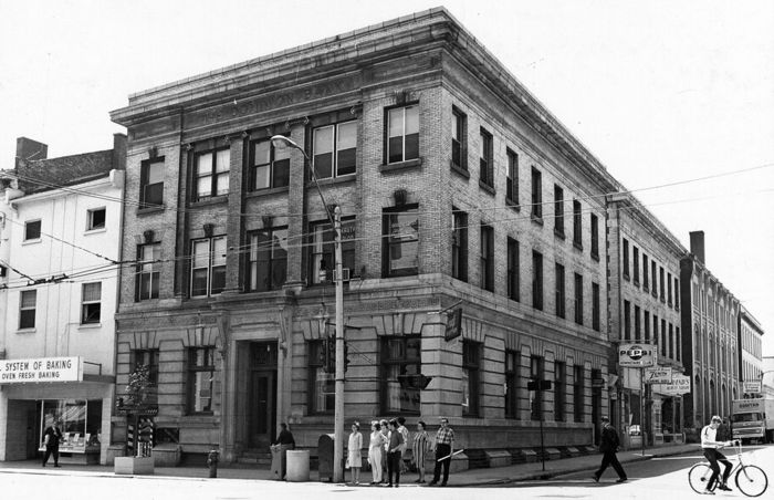
The Dominion Bank on the southeast corner of King Street West and MacNab, in the late 1960s. The Dominion Bank occupied the entire lower floor and there were apartments in the upper two floors. When it was built in 1908, the Hamilton Herald described it as “a fine three-story brick and stone edifice.” Fine edifice, or not, it would also fall to the wrecker’s ball, as did all the other buildings along MacNab.
Figure 4
Northeast corner of King Street West and MacNab Street North, 1968. This corner and this section of MacNab Street would totally disappear to create a giant super-block. The Victorian dormers and cornices along King Street West would be replaced by the steel and glass of the Stelco Tower and the Jackson Square commercial mall.
Figure 5
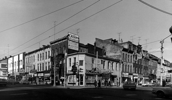
Northwest corner of King Street West and MacNab Street. This section of MacNab Street would disappear under the super-block. Notice the expropriation sale notices in the windows. In 1965 the Urban Renewal Committee reported that, while a survey of downtown buildings found 31 per cent to be in good condition, it “did not take into account such other factors as the small size of most buildings and lots and the frictional blight through the juxtaposition of incompatible uses through much of the area.” The diversity of this older section of Hamilton was seen as a blighting influence to the entire downtown.
Figure 6
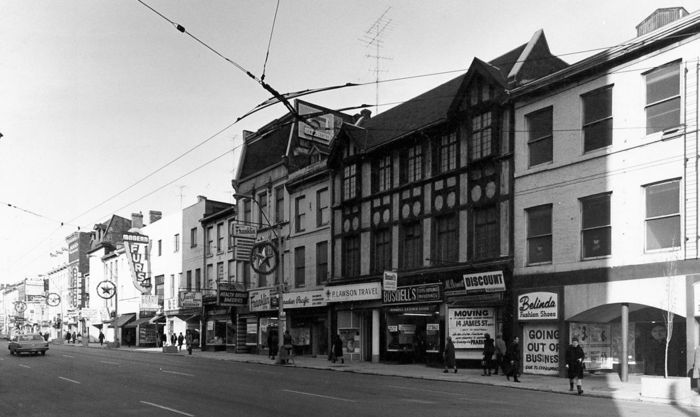
North side of King Street West, between James and MacNab Streets, 1968. The “Going Out of Business” and “Moving” signs are in the window. This part of the street was slated for demolition in early 1969. The downtown mall, called Jackson Square, would replace these buildings.
Figure 7
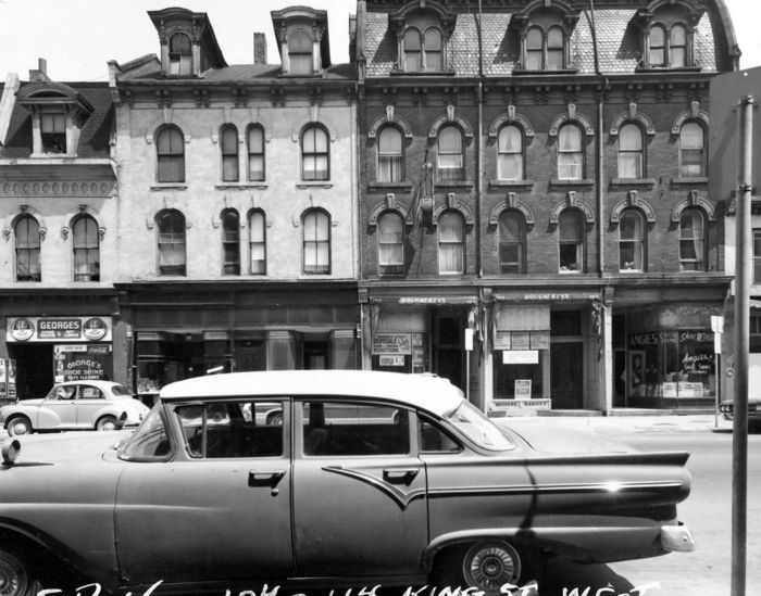
104 to 114 King St. West, north side, between Bay and Park Streets, circa 1965. The elaborate brickwork, the dormers, the mansard roof, and the cornice mouldings were not considered worth preserving during the urban renewal destruction. The buildings were deemed old and at risk of blight and they all came down to be replaced by the commercial mall. Some merchants were able to briefly relocate to a make-shift mall on Park Street during the construction. Park Street would eventually disappear entirely to be replaced by the super block.
Figure 8
Iroquois Hotel, on the northeast corner of King Street West and Park, late 1960s. This hotel was originally called the Franklin House and was built in the mid-nineteenth century. It was one of many hotels that were destroyed in the urban renewal area to be replaced by one modern hotel attached to the commercial mall.
Figure 9
South side of King Street West between James and MacNab, 1960s. The Royal Bank of Canada at 21 King Street West, with its ionic columns, was remodelled in 1903 and at that time the bank’s quarters were said to be “considerably improved and modernized.” In October 1956, the Hamilton Spectator reported that the Thomas Lee Jewelry store, to the left of the bank, at 17 King Street West, had installed “a modern street level front with modernized display windows.” This section of King Street would be the last to be demolished and was initially not part of the original Civic Square scheme.
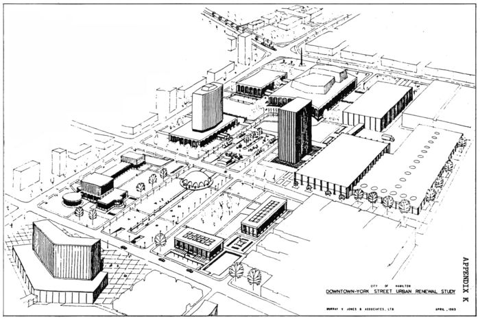
Other images, however, do help to explain the community’s enthusiasm for the urban renewal destruction—these images are not photographs but instead present the plan for the future Civic Square, published in the Hamilton Spectator in 1965. The plan (figure 10) and the accompanying artist’s sketch (figure 11), show King Street West cutting through a large open space framed by civic buildings. Long pools of water and public gardens cross two super-blocks to link the modernist City Hall to the grand auditorium. This was the plan that was supposed to “leapfrog Hamilton into the 21st century,”[4] and it is very different from the diminished sidewalks and walls of concrete that now line this section of King Street West, where the automobile reigns supreme. Hamilton’s modernist architect Anthony Butler described the original 1965 plan for the “grand axial mall” as “distressingly beaux arts in conception” but he was forced to admit that “it caught the public fancy.”[5] Modernist architecture’s simple lines and forms were a reaction against the more ornate and grandiose beaux arts style which emphasized symmetry and grand vistas and was popular from the late nineteenth century to the early twentieth century. Judging from the protest that erupted when the plans for the gardens and pools were threatened, the citizens of Hamilton cared a great deal for the greening of their downtown, whether modernist or beaux arts in style.
Figure 10
The 1965 plan for the Civic Square. This plan featured a planetarium, a sculpture court, and an auditorium, surrounded by gardens and roads that cross King Street West. The plan shows lots of public space between the buildings.
Figure 11
An artist’s sketch of the Murray Jones Downtown Urban Renewal Plan, 1965. In this sketch the gardens and long pools look inviting. The civic buildings are surrounded by open space. The downtown looks green and clean.
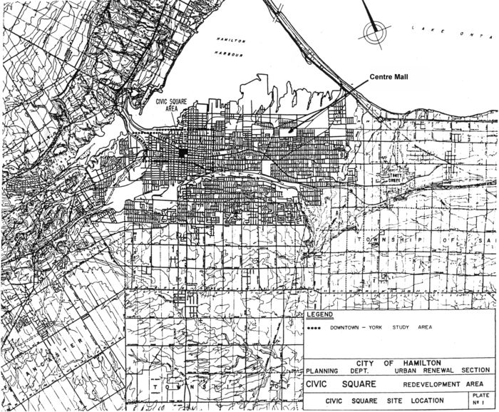
The gardens and pools would replace the downtown blight that the old buildings had come to represent. Hamilton businessmen had prospered in these old buildings as the city grew, but in 1955 when the Greater Hamilton Shopping Centre opened to the east on the old Jockey Club race track, now known as Centre Mall (figure 12), the dual threat of suburban growth and the suburban mall made the nineteenth-century downtown storefronts look out of date. In 1957, the Hamilton Downtown Association began to lobby for an urban renewal study to be carried out by the federal government. However, when this study was completed in 1958, planner Mark David could not recommend redevelopment for the downtown because the federal-provincial cost-sharing program was initially designed to improve housing conditions and the downtown was a commercial district. Federal and provincial urban renewal money began to flow into Hamilton in 1958 to allow the city to expropriate and tear down Lake Ontario cottages for its first urban renewal project on Van Wagner’s and Crescent Beaches. Hamilton’s next government-funded urban renewal project focused on the residential North End, again a project fully supported by the downtown businessmen who continued to lobby politicians to expand the urban renewal program to allow for downtown redevelopment. Finally, in 1964, the National Housing Act was amended to allow for federally assisted civic improvement, and Hamilton immediately requested government funding to begin an urban renewal study of the 1,150 acres of central Hamilton (figure 13).
Figure 12
Map of Hamilton, south of Hamilton Harbour. Urban Renewal map showing Hamilton’s Civic Square and the city’s first shopping mall, now known as Centre Mall, which opened in 1955.
Figure 13
Map of the Civic Square Urban Renewal Scheme. This 1965 map positions the Civic Square in the middle of the Central Hamilton Urban Renewal Scheme. The York Street plan was connected to the Civic Square plan because York Street was seen as the grand boulevard that would lead up to the newly developed downtown core.
In April 1965, planner Murray Jones presented his plan for the Civic Square. Under this plan King Street West would travel one way west between Bay and James, cutting across new streets that flowed around the axial pools, and through open space in front of a department store and an office building to the north, and a library and parking garage to the south (figures 10 and 11). The familiar older buildings would be torn down, and the open spaces left behind were said to be vital to the project because they would allow fresh air to circulate in the core.[6] The downtown core was perceived as ramshackle and slum-like[7] and in need of a good airing out.
In June 1968, the King Street merchants and tenants were told they had six months to vacate the buildings. Although the 1965 urban renewal plan was well known, the timing for the destruction had changed so often that the occupants were surprised that they had to leave at such short notice.[8] “The stores and residents will go, but so will the filthy back lanes, the grubby roof tops and the decrepit faces of the second and third floors,” reported the Spectator, “and like a phoenix rising from the ashes will grow a concrete skyscraper—the temple of the twentieth-century living.”[9] Concrete would replace the stone facades, and Hamilton would be able to stand proud as it approached the 125th anniversary of its incorporation as a city, knowing that it would finally look “modern”—a term used by politicians and commentators to signify the new, up-to-date style.
Since the late 1950s, Hamilton politicians and business people had linked downtown redevelopment to the goal of becoming modern and up-to-date, of being able to compete with Toronto to the east and Buffalo to the south. The “ambitious city” was determined to update its look to reflect its potential and its important position within Canada as an industrial powerhouse. The modernist look it sought eschewed historical connections. The solid old buildings, some built of stone hewn by Hamilton’s earliest citizens, were no longer valued. Smooth edges of steel and glass represented the new machine look. History and ornamentation had little value, so very few mourned the old buildings’ destruction[10] (see cover image). The new look needed to supersede the old and the buildings started to come down before the plan to replace the buildings was confirmed. In addition to the notion that something had to be done quickly was the pride that Hamiltonians felt in accomplishing something really big. The Civic Square Urban Renewal Scheme was said to be the largest downtown urban renewal land assembly project in Canada.[11] The city believed that it was doing something that would “have a profound effect on downtown urban renewal throughout the country” and therefore the city and the developer would have to work well together “with dedication to the sincere objectives of the program.”[12] Unfortunately, Hamilton chose a developer with an inferior physical plan but who also promised higher economic returns to the city.[13] In the end, the hometown favourite was unable to deliver the project. With the downtown blocks flattened, the city would engage in anxious deliberations for more funding and search for a new developer to take over the project. As money grew tighter, the public’s enthusiasm for gardens and pools in the Civic Square was disregarded in order for the city to recoup its costs. In July 1968, the plan for the Civic Square was redrawn to increase the commercial components of the scheme by 50 per cent.
King Street West would no longer cross a square of gardens and pools and the street was no longer part of a grand vision for the Square; instead it became a transportation corridor where the flow of traffic cut through the two super-blocks (figure 14) as cars moved through the city. The stores to the north turned away from King Street and into an enclosed mall (figure 15). The civic buildings now confined to the south side were to have walls of high concrete. King Street West was to become divorced from pedestrian life. As the public part of the Square shrank and the commercial interests increased, the automobile was the only winner. With roots in European industrial architecture and social housing, straight modernist lines were easy and cheap to replicate in steel and concrete. The city would rely on the modernist machine aesthetic of efficient straight lines and monotonous concrete construction to transform King Street West from a street where people had window-shopped to a street where traffic flowed.
Figure 14
Revised Civic Square Plan, May 1969. The new plan had no room for gardens or long pools. The commercial space now dominates the scheme and a sky walk now crosses King Street West. The buildings are much more crowded together than in the original plan and King Street West is like a canyon running between the two blocks.
Figure 15
Map showing position of the two super-blocks on either side of King Street West within the Urban Renewal Area. These super-blocks would turn King Street West into a thoroughfare for cars ensuring that traffic would move efficiently, unhindered by the intersections for the small streets. Park, Charles, and Market Streets would disappear under the super blocks, as would parts of MacNab and York Streets.
Two super-blocks would be created on either side of King Street West (figure 16). MacNab Street would stop at King, its north section lost to the large steel and glass Stelco Tower. Park and Charles Streets would disappear entirely to create the super-blocks. This allowed architects to design their buildings unhindered by roads as well as allowing traffic to flow one way along King without the interruption of stop signs and intersections. The super-blocks also decreased the opportunity for human encounters on the street. As Marshall Berman has written, our culture once celebrated the street: it “was experienced as the medium in which the totality of modern material and spiritual forces could meet, clash and work out their ultimate meanings and fates.”[14] When the automobile was permitted to dominate the agenda, Berman’s “family of eyes” get poked out, the democratizing force of different people and classes on the street was driven away. Urban renewal critic Jane Jacobs also criticized the creation of the super-block and recognized a downtown’s short city blocks as “valuable because of the fabric of intricate cross-use that they permit among the users of a city neighbourhood.”[15] By allowing for many different ways of travelling through the downtown, more connections are created, but when a major road becomes a one-way traffic corridor, with limited access, the intricate connections become lost.
Figure 16
The intersection of King Street West and James Street, summer 1971. The new super-block, created for the Jackson Square Mall, has transformed the north side of King Street West beyond recognition at this important city intersection. The diverse storefronts were lost to the large commercial mall. The crane stands beside the Stelco Tower that is under construction.
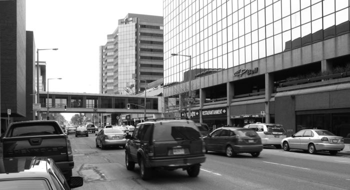
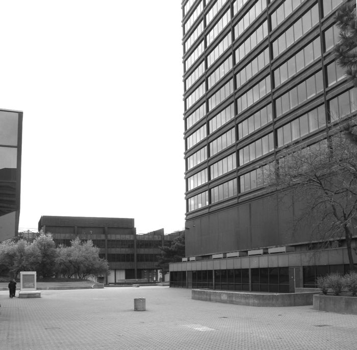
The modernist planners wanted to separate the car from the pedestrian. When the plans were redrawn to replace the Civic Square’s pools and gardens with more commercial properties, the planners decided to elevate the pedestrians above the street level. Architect Arthur C. F. Lau described it this way: “Pedestrian movement routes are grade-separated from vehicular circulation throughout the project area with bridges at plaza level and roadways depressed below the existing grade.”[16] Others would describe it as a “Plus 15” skywalk system, similar to what exists in Calgary, Alberta. In a recent interview, retired Hamilton planner Vladimir Matus described the street level as the basement, with the green space fifteen feet or more above the street. Stores were supposed to line the pedestrian plaza above the street, but they were never built. “The vision was massive,” says Matus, “the Plus 15 system was supposed to be part of a larger system. There were to be bridges to City Hall and beyond but they were never built.”[17] Today only one pedestrian skywalk crosses King Street West (figure 17) and the supposed green space on the roof of the enclosed shopping mall, now called Jackson Square, is paved and eerily empty. The elevated paved plaza is accessible from King Street West by rarely used stairs (figure 18) and most people prefer to walk along the windswept diminished sidewalks of the old street instead of the empty urban rooftop where one feels very alone (figure 19). “In order for the system to work you need a critical mass,” says Matus. And that critical mass never materialized. Urban renewal promoters wanted to extend the demolitions to achieve a totally renewed city without any material connections to the past.
Figure 17
King Street West, 2008. The Sky Walk linking the two super-blocks together crosses above the cars along King Street West. Pedestrians are discouraged from walking leisurely along this busy, car-dominated street because there are no longer shop windows to gaze into, the sidewalks are narrow, the wind whips along the corridor, and the cars move very quickly.
Figure 18
Staircase on north side of King Street West, 2008. This staircase climbs up to the roof of the mall, although it is rarely used. The sidewalk is narrow and not very interesting to walk along. There are few windows to look into. In order to enter a shop, the shopper needs to use the mall entrance. Here along King Street West the shops have turned inward away from the street.
Figure 19
“Plus 15” pedestrian plaza, 2008. The plaza, above the street, on the roof of the mall, is mainly empty and rather eerie. It was supposed to replace the gardens and pools that people were anxious to keep but very few people leave the street to walk up the stairs to this raised plaza.
When the demolitions began on King Street West, the planners and urban renewal authorities complained of restrictions to their vision. Representatives of the Hamilton Downtown Association demanded that urban renewal be seen as a system, and not as a plan. They didn’t want to be constrained by the approved plan but wanted the freedom to continue to destroy and to rebuild their modern city. They saw the urban renewal system stretching out beyond the distinct urban renewal area boundary to encompass the entire downtown.[18] To this day, Matus blames “hippy anti-intellectualism” for stopping planners from continuing with urban renewal development. He saw urban renewal critic Jane Jacobs as an amateur who discredited the expert planner. “People knew better,” he says with derision, and for that reason urban renewal and the Plus 15 walkway did not spread throughout the downtown core.[19]
What the people knew is that they were not getting what the initial urban renewal plans and sketches had promised. As the buildings were falling, the public began to understand that they were not going to get their central green space. Sheila Zack, the wife of a well-known downtown businessman, organized a protest committee called SOS, Save Our Square, to recover the original vision for the Civic Square. Her committee didn’t want to stop urban renewal. They just wanted to retrieve the original plans for lots of open public space. The committee took their complaints to the Ontario Municipal Board but it ruled in favour of the 1968 plan. The federal government’s report by Paul Hellyer’s Federal Task Force on Housing and Urban Development would eventually end the federal subsidies for wholesale downtown destruction but it would be too late for Hamilton’s King Street West between James and Bay Streets.
The “facelift” that brought down the buildings and erased three cross streets was hastily completed, and the city’s politicians grasped at inexpensive modernist solutions to replace the void that was left behind once the enthusiastic destruction was complete. This section of King Street West lost its material diversity and its connection to the past. The aesthetic was transferred from the beauty contained in an individual building’s facade to the beauty of efficient movement where a machine’s speed was adopted to represent the city’s status and its future, and the slow pedestrian was discouraged away from the street. The aesthetic embraced a system, imposed from above by government money and the urban planners’ grandiose vision. The section of King Street West between James and Bay was transformed from a destination where pedestrians strolled and shopped to a wide thoroughfare where the automobile had priority.
The before and after photographs demonstrate what Kahn and McAllister meant by the phrase “unstable, tenuous nature of the postmodern present.”[20] In this industrial city’s once beloved downtown, solid stone buildings were carted away as rubble, but the photographs do very little to help us understand the motivation behind all the destruction. The plan and sketches for the original Civic Square, showcasing its gardens and elegantly placed civic buildings, do a better job of explaining why urban renewal caught Hamiltonians’ imagination. After years of hearing how the downtown was replete with slum-like derelict buildings, urban renewal funds offered Hamiltonians a chance to dream of greening the core with beautiful pools and gardens, making the downtown reflect the pride they felt for their city. Unfortunately the dream had no room for the legacy of the past, and the clean sweep of the redevelopment area left no reminders of the pedestrian-friendly street. Hamiltonians wanted to beautify their city, and the initial scheme responded to their aspirations, but these plans, like many urban renewal schemes, looked better on paper and needed more funds than the ambitious city could raise. Hamilton had latched onto a misconceived solution to its perceived problem and then compounded the outcome by poorly executing the renewal. Once the buildings were down, the politicians were forced to disregard the original plans that included the gardens and pools. If the people of Hamilton had known urban renewal would turn a revered street into an aggressive traffic corridor where the pedestrian was unwelcome, it is unlikely they would have let politicians, business leaders, and planners give King Street West its modernist makeover.
Parties annexes
Acknowledgement
Photographs courtesy of Phil Aggus, Roger Chapman, John Morris, and the Hamilton Spectator, with thanks to Gerald B. Aggus, Anna Morris, Roger Chapman, Howard Elliot and the Hamilton Public Library Archives. Special thanks to Professor Richard Harris.
Contributor/Collaboratrice
Margaret Rockwell is a PhD candidate in history at McMaster University, Hamilton, Ontario. She is interested in the aesthetic behind the urban renewal projects of the 1950s, 1960s, and 1970s. Her thesis examines the urban renewal projects of Buffalo and Hamilton.
Margaret Rockwell est doctorante en histoire à McMaster University, Hamilton, Ontario. Elle s’intéresse à l’esthétique de la rénovation urbaine des années 1950, 1960, et 1970. Sa thèse examine l’esthétique des projets de rénovation urbaine à Buffalo et à Hamilton.
Notes
-
[1]
“Plans Five Days Away,” Hamilton Spectator (hereafter HS), 6 September 1967.
-
[2]
David Proulx, Pardon My Lunch Bucket (Hamilton: Corporation of the City of Hamilton, 1972).
-
[3]
Annette Kuhn and Kirsten Meiko McAllister, “An Introduction,” in Locating Memory: Photographic Arts, ed. Annette Kuhn and Kirsten Meiko McAllister (New York: Berghahn Books, 2006), 14.
-
[4]
“Bold Downtown Plan Unveiled,” HS, 9 April 1965.
-
[5]
Anthony Butler, “Perspective,” Canadian Architect 14, no. 6 (1969): 7.
-
[6]
“Bold Downtown Plan Unveiled,” HS, 9 April 1965.
-
[7]
“We’ve Got to Densify: City Centre a Slum,” HS, 14 December 1967.
-
[8]
Robert Harry Riddet, “Urban Renewal as a Catalyst of Change in the Retail Business: The Case of the Civic Square, Hamilton, Ontario” (master’s thesis, University of Western Ontario, 1969), 42.
-
[9]
“Time Gentlemen Please,” HS, 1 February 1969.
-
[10]
No reports of organized were opposition found in the newspapers of the day, This was confirmed by Herman Terpstra, interview, 2 June 2004, Hamilton.
-
[11]
“Merchants Appeal Closing,” HS, 16 December 1967.
-
[12]
Joint Review Committee on the Commercial Development Proposals, “Hamilton Civic Square,” 1967, 52, 307.30416 HAM, Hamilton Public Library Archive.
-
[13]
Ibid., 51.
-
[14]
Marshall Berman, All That Is Solid Melts into Air: The Experience of Modernity (New York: Simon and Schuster, 1982), 316.
-
[15]
Jane Jacobs, The Death and Life of Great American Cities (New York: Random House, 1961), 186.
-
[16]
Arthur C. F. Lau, “Hamilton Civic Square,” Canadian Architect 16 (March 1971): 45–47.
-
[17]
Vladimir Matus, interview, 31 May 2008, Toronto.
-
[18]
“It’s Time for More Downtown Renewal,” HS, 28 January 1969.
-
[19]
Matus, interview.
-
[20]
Kuhn and McAllister, “An Introduction,” 14.
Liste des figures
Figure 1
King Street West at James, 25 May 1960. Traffic along King Street became one-way eastbound in 1956. Despite the one-way traffic, people still enjoyed shopping along King Street West. Notice the diversity of storefronts and the number of shoppers. King and James was said to be one of the busiest intersections in Canada.
Figure 2
South side of King Street West at MacNab Street and the west side of MacNab, June 1968. The buildings at 47 to 51 King Street West were bought by the city in 1965. Notice the variety of storefronts on MacNab Street as well as on King Street West. This whole block was levelled to create a super block dominated by tall, windowless concrete walls.
Figure 3
The Dominion Bank on the southeast corner of King Street West and MacNab, in the late 1960s. The Dominion Bank occupied the entire lower floor and there were apartments in the upper two floors. When it was built in 1908, the Hamilton Herald described it as “a fine three-story brick and stone edifice.” Fine edifice, or not, it would also fall to the wrecker’s ball, as did all the other buildings along MacNab.
Figure 4
Northeast corner of King Street West and MacNab Street North, 1968. This corner and this section of MacNab Street would totally disappear to create a giant super-block. The Victorian dormers and cornices along King Street West would be replaced by the steel and glass of the Stelco Tower and the Jackson Square commercial mall.
Figure 5
Northwest corner of King Street West and MacNab Street. This section of MacNab Street would disappear under the super-block. Notice the expropriation sale notices in the windows. In 1965 the Urban Renewal Committee reported that, while a survey of downtown buildings found 31 per cent to be in good condition, it “did not take into account such other factors as the small size of most buildings and lots and the frictional blight through the juxtaposition of incompatible uses through much of the area.” The diversity of this older section of Hamilton was seen as a blighting influence to the entire downtown.
Figure 6
Figure 7
104 to 114 King St. West, north side, between Bay and Park Streets, circa 1965. The elaborate brickwork, the dormers, the mansard roof, and the cornice mouldings were not considered worth preserving during the urban renewal destruction. The buildings were deemed old and at risk of blight and they all came down to be replaced by the commercial mall. Some merchants were able to briefly relocate to a make-shift mall on Park Street during the construction. Park Street would eventually disappear entirely to be replaced by the super block.
Figure 8
Iroquois Hotel, on the northeast corner of King Street West and Park, late 1960s. This hotel was originally called the Franklin House and was built in the mid-nineteenth century. It was one of many hotels that were destroyed in the urban renewal area to be replaced by one modern hotel attached to the commercial mall.
Figure 9
South side of King Street West between James and MacNab, 1960s. The Royal Bank of Canada at 21 King Street West, with its ionic columns, was remodelled in 1903 and at that time the bank’s quarters were said to be “considerably improved and modernized.” In October 1956, the Hamilton Spectator reported that the Thomas Lee Jewelry store, to the left of the bank, at 17 King Street West, had installed “a modern street level front with modernized display windows.” This section of King Street would be the last to be demolished and was initially not part of the original Civic Square scheme.
Figure 10
Figure 11
Figure 12
Figure 13
Map of the Civic Square Urban Renewal Scheme. This 1965 map positions the Civic Square in the middle of the Central Hamilton Urban Renewal Scheme. The York Street plan was connected to the Civic Square plan because York Street was seen as the grand boulevard that would lead up to the newly developed downtown core.
Figure 14
Revised Civic Square Plan, May 1969. The new plan had no room for gardens or long pools. The commercial space now dominates the scheme and a sky walk now crosses King Street West. The buildings are much more crowded together than in the original plan and King Street West is like a canyon running between the two blocks.
Figure 15
Map showing position of the two super-blocks on either side of King Street West within the Urban Renewal Area. These super-blocks would turn King Street West into a thoroughfare for cars ensuring that traffic would move efficiently, unhindered by the intersections for the small streets. Park, Charles, and Market Streets would disappear under the super blocks, as would parts of MacNab and York Streets.
Figure 16
The intersection of King Street West and James Street, summer 1971. The new super-block, created for the Jackson Square Mall, has transformed the north side of King Street West beyond recognition at this important city intersection. The diverse storefronts were lost to the large commercial mall. The crane stands beside the Stelco Tower that is under construction.
Figure 17
King Street West, 2008. The Sky Walk linking the two super-blocks together crosses above the cars along King Street West. Pedestrians are discouraged from walking leisurely along this busy, car-dominated street because there are no longer shop windows to gaze into, the sidewalks are narrow, the wind whips along the corridor, and the cars move very quickly.
Figure 18
Staircase on north side of King Street West, 2008. This staircase climbs up to the roof of the mall, although it is rarely used. The sidewalk is narrow and not very interesting to walk along. There are few windows to look into. In order to enter a shop, the shopper needs to use the mall entrance. Here along King Street West the shops have turned inward away from the street.
Figure 19
“Plus 15” pedestrian plaza, 2008. The plaza, above the street, on the roof of the mall, is mainly empty and rather eerie. It was supposed to replace the gardens and pools that people were anxious to keep but very few people leave the street to walk up the stairs to this raised plaza.


