
Résumés
Abstract
How was subsistence livestock linked to architecture and the urban development in the settlement of 17th and 18th century Montreal?
This article argues that landscapes and buildings interact with and accommodate the transformation of livestock products and by-products along various stages; and, that these animal parts contribute to defining urban landscapes. The paper presents a novel analytical framework to study foodscapes, and more particularly meatscapes by way of identifying spaces through which animal parts transited, and by spatially mapping them. It does so via a mixed methodological approach, including researching legal documents, travelers’ notes, databases, historical maps and plans dating back to the French period. Examining processes and spaces involving subsistence livestock, their products and by-products as well as individuals related to their transformation provides a new perspective on how ordinary activities shaped the lives and the spaces in a settlement.
Résumé
Quels étaient les liens entre le bétail de subsistance, l’architecture et le développement urbain à Montréal au 17e et au 18e siècles? Cet article examine l’interaction entre les processus de transformation des produits et sous-produits d’origine animale, les paysages, et les bâtiments. Les produits d’origine animale contribuaient effectivement à l’évolution des paysages urbains. Favorisant une approche novatrice, qui consiste à établir des liens entre les produits alimentaires et les bâtiments dans lesquels ceux-ci étaient produits, l’auteure invite le lecteur à concevoir les échanges alimentaires sous un nouveau jour. Cette « cartographie » se sert d’une approche méthodologique mixte pour analyser divers documents, entre autres : des documents de nature juridique, des notes de voyageurs, des données issues de banques de données, des cartes historiques, et des plans qui datent de la période française. En examinant les processus et les espaces dans lesquels étaient transformés les produits d’origine animale, les produits et les sous-produits résultant de cette transformation, ainsi que le rôle des acteurs dans ce contexte, l’auteure propose une nouvelle manière de concevoir et de comprendre les activités quotidiennes à l’époque du peuplement canadien.
Corps de l’article
Introduction
This study explores the processes and spaces associated with meat and investigates their respective interactions within a settlement and their influence on the landscape of Montreal in 17th and 18th century New France.[1] It does so, by introducing the notion of meatscapes, by surveying and mapping them. Meatscapes are defined by this research as spaces associated to different phases in the journey of subsistence livestock from field to waste, and encompass raising, keeping, slaughtering, preserving, preparing and trading livestock in whole or in part for consumption as well as for other purposes like garment. Tools, objects, rooms, outbuildings, yards, parcels, fields, infrastructure and waterways also interact with these stages in the production, transformation, commerce and disposal of subsistence livestock parts and by-products, contributing to a broader picture of meat processes and spaces.
The case examined involves 17th and 18th century Montreal. According to Gilles Havard and Cécile Vidal, circa the end of the French regime in the mid-18th century, the urban population living along the Saint Lawrence River had accounted for 20-25 percent of the total population of New France. At that time, Montreal was the second most populated town after Quebec City with 5,000 inhabitants.[2] The planning, development and architectural history of the island and its town have been approached by a number of researchers.[3] However, little research has been conducted in depth on links between foods and spaces. During the French regime, Montreal grew and developed albeit not without obstacles. Its climate was harsh, but milder in comparison to other Canadian settlements, and it enabled life-sustaining agricultural activities; in prosperous times, it even produced surpluses.[4]
Methodology
To illustrate the interconnections between spaces and foods, this study utilizes a flow chart diagram as well as urban and architectural representation techniques to investigate locations and plots in the town of Montreal. It combines the information found to represent them visually and at different scales through the use of maps, plans, axonometric views and schematic sections, in order to enable readers to project themselves in a context that can no longer be seen or physically experienced.
But how to pursue, identify and reconstruct these linkages in a data-scarce period like 17th and 18th century New France? Architectural drawings related to the surveyed timeframe are scant, not only because little physical evidence remains to this day, but also because depictions were usually authored by engineers and mainly portrayed infrastructure works; the few exceptions showing wealthy homes and religious institutions were researched through the Canada-France Archive database and the Archives nationales d'outre-mer. To fill the gap, this research sought records from travellers’ notes[5] and legal documents compiled by Edouard Z. Massicotte.[6] These include regulations and rules that together help identify common practices affecting cultivated lands and the development of a town and portray measures authorities took to manage them. In addition, this study consulted the Adhémar database,[7] a particularly valuable asset. Its interactive interface assists researchers in reconnecting people to their respective profession at a given time and in locating parcels of land they owned, leased or occupied thereby enabling the reconstruction of a clearer spatial picture of Montreal at that time. This database can be searched through different variables including the production of food in which butchers are recorded. Following this initial step, one can survey in greater detail the parcels associated with these inhabitants, including plot sizes, built areas and, in some cases, material used. This information ultimately permits the quantification of spaces occupied by these artisans. Further, transcribed notarial deeds related to butchers were also consulted through records archived at the Société généalogique canadienne-française. Moreover, a number of historical museums like the Château Ramezay, the Maison Saint-Gabriel, Pointe-à-Callière, the Montréal Museum of Archaeology and History, the Saint Sulpice Seminary in Montréal, the Sisters of Charity of Montreal, and the Musée des Hospitalières de l’Hôtel-Dieu de Montréal were also visited. Finally, the paper also relies on secondary sources, like archeological reports, historical thesis and biographies.
The resulting rich data collected is then used to apply the proposed framework for the study of the nexus between foods and spaces. In this paper, this framework focuses on meat, its products or by-products, architecture and landscape and includes (i) identifying the processes they underwent (Figure 1) and (ii) exploring how they affected domestic, private and public spaces. The result is animating representations of urban environments hitherto frozen in time into more dynamic networks of artisans, private and public spaces - through which livestock was present in whole or in part in a variety of forms - contributing to meatscapes.
Processes Associated to Meatscapes
Livestock States and Processes
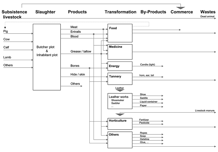
Figure 1 offers a schematic representation of the phases through which livestock made its way to food and other products.[8] Animal slaughter usually took place in the homestead, either indoors (or in an extension of the house), or outdoors. The butcher, or, the inhabitant, divided the slaughtered animal into different parts, including meat, entrails, blood, grease or tallow, bones and hides. Due to its properties, blood was collected in wood, or, leather containers, and grease and tallow were most probably stored in wood barrels crafted by a cooper, hence extending the network of artisans contributing to livestock-related processes. Non-edible livestock products were further transformed into several by-products like medicine,[9] energy, leather works,[10] horticultural fertilizer and pesticide, as well as other common household goods, like glue, soap and candle which illuminated spaces at night. Live, dead, edible parts of livestock, hides, tallow, etc. all contributed to meatscapes in different ways. For example, they helped fortify the population and mark festive occasions with the abundance of meat-based dishes on tables (its absence during meagre days was associated to the religious calendar); they were also considered towards healing practices for the sick (when used as a remedy), but also adversely affected inhabitants’ health (when rotten meat was consumed); moreover they helped dress inhabitants and illuminate rooms at night; but also overcrowded streets and polluted waterways.
Figure 1
Livestock products and by-products diagram
Spaces Associated to Meatscapes
Keeping Livestock
Prior to the establishment of European colonists in Canada, there were no cows, sheep, or hens and meatscapes were associated to hunting. The French imported subsistence livestock and draught animals from the Old World[11] up to the mid 1670’s.[12] After that date, such imports began to drop, following a letter addressed to the King of France by Jean Talon, the intendant of New France. In it, he mentioned that there were sufficient cattle to sustain the settlement.[13] Raising and keeping subsistence livestock was essential, as meat was the second most common element of colonists’ diets;[14] and the Island of Montreal was one of the most important livestock centres in New France.[15]
Hardy estimated that between 1740 and 1755, in the town of Montreal, 71% of the artisans surveyed kept domestic animals.[16] This included pigs, horses and poultry, and their value roughly accounted for 4.8% of their total belongings. Buteau complemented Hardy’s study and estimated that on average, one third of Montreal households kept two oxen and two to three milk cows, a dozen hens and a rooster.[17] Habitants either owned, or, leased animals including cows, oxen, bulls, horses and other livestock;[18] they were considered valuable and were also included in post mortem inventories.
In terms of location, subsistence livestock was found in houses, in barns usually built of wood,[19] on plots, in streets, on pastures and commons,[20] and on fields. To bring some order to the settlement authorities regulated their keeping out of houses (especially in the case of pigs raised in the town and they imposed a fine on those who carried on with this practice),[21] within fenced plots and concessions to protect cultivated lands (particularly between sowing and harvest periods),[22] and away from the public domain (not to encumber streets or harm pedestrians). Following the harvest, livestock was released and left lawfully wandering in the vicinity of the town of Ville Marie to fatten before the winter months ahead.[23] Overall, keeping livestock had effects on the colony. Meatscapes shared and negotiated spaces with other activities which required the intervention of authorities to spatially separate livestock from cultivated crops intended for human consumption.
Spaces associated to butchers
Rules and ordinances also limited the number of butchers in Ville-Marie and aimed to set the price of the meat. For example, in 1710, Guyon dit Després, Paul Bouchard, Jean Brunet dit Lasablonnière and Nicholas Lecours were granted the privilege to practice their profession as butchers for three years (their plots are represented for the year 1725 in Figure 2).[24] While individuals were not allowed to sell meat without an authorisation, a number of religious institutions were exempted from this regulation.[25]
According to the Adhémar database consulted for each year between 1642-1704, about a dozen butchers were identified practicing for longer or shorter periods during this timeframe. While the majority were male, Catherine Lucos was one of the rare female butchers, practicing between 1700 and 1702. Another was Louise Leblanc, both a tavernkeeper and a butcher. Following the death of her butcher husband Michel Lecours, she most probably continued his business, and eventually married another butcher, Paul Bouchard.[26] In some instances, butchers also partnered with each other. For example, in 1692, Jean Brunet (whose property is identified Figure 2 for the year 1725) and Claude Robillard listed in a record 14 animal purchases combined as well as the income from meat and cow hides they sold.[27]
1725 is an informative year because the Adhémar database and a map drawn at that time by a French engineer Chaussegros de Léry enable the piecing together of a snapshot of butchers’ properties and buildings. Table 1 lists their properties and buildings and Figure 2 shows their location.
Table 1
Butchers’ properties in 1725

The Adhémar database indicates that for that year, the settlement was subdivided into 442 plots with 337 buildings. Constructions were mainly composed of two materials: stone and wood. For that specific year, the database identifies five butchers living within the limits of the town, all of them landlords. An example is Jean Brunet, the Montreal-born father of eleven, who had been in the butcher business from a young age.[28] Records indicate he was a successful one – with steers and fattened cattle and eventually a stake in the skin and tanning trade, which allowed him to own two parcels of land. Bouchard, Lecours and Serre only had one parcel, but Guyon, who also provisioned the King’s warehouse,[29] owned five, including two unbuilt ones.
Figure 2
Multi-scale identification in plan of butchers’ parcels in 1725
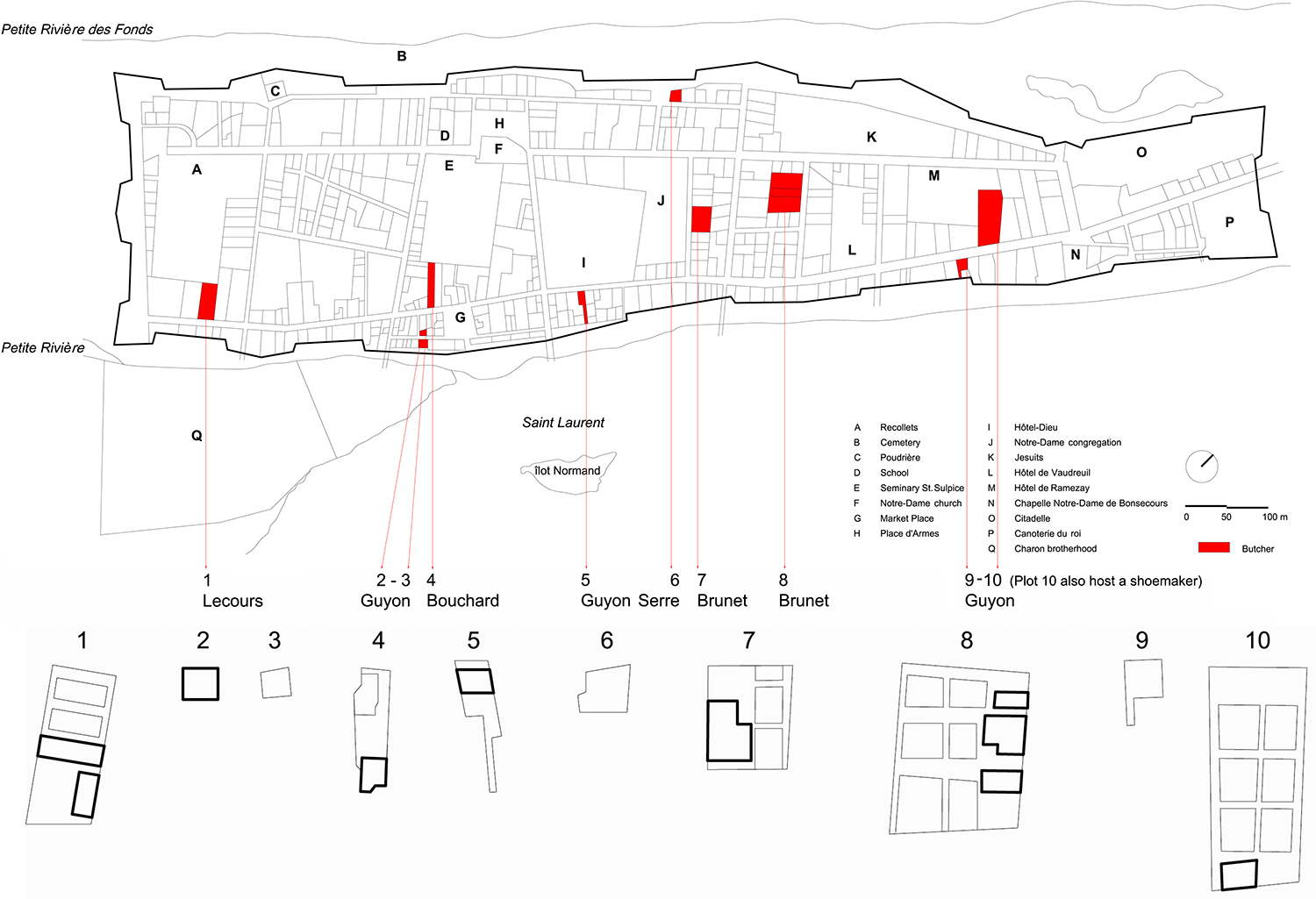
On the bottom, the thick outline delimits buildings and the lighter one represents the parcel or the garden subdivisions.
Parcel size varied considerably and ranged roughly from 59 to 1,919 m². In five cases, there was just one building on the plot, and in three cases there were two or more. Their function is specified and includes a house, a bakery and a barn/cowshed.[30] Surprisingly, ice houses are not mentioned, which might suggest that if the plot contained one, either it was integrated to the building and was probably in the cellar, or, that it was a self-built outbuilding that did not require a mason’s intervention, or a record. To cross-reference the above quantitative data that provided links between artisans, parcels, buildings and areas, this study also sought evidence from iconographical sources. Their combination informs a more comprehensive, physical understanding of meatscapes’ phases. The top part of Figure 2 was reconstructed based on a 1725 map (available on the Adhémar database), and the bottom part shows buildings and the layout of plots based on another by Chaussegros de Léry. The composite map of Figure 2 locates butchers’ parcels and underlines the heterogeneity of this category of food-artisans, both in the size of parcels and buildings, as well as in their locations. When gardens are depicted, they are situated in the backyard. Smaller parcels are found close to the market. Two of the five butchers identified had one or two plots close to the market place - most likely to facilitate the commerce on market days. Nevertheless, also evident from this combined data is the twin observation that a good number of butchers’ properties are positioned along, or just off, Saint Paul Street, whereas none of them are on Notre-Dame Street. The reason for this is probably because Saint Paul was the main commercial street. Another important aspect of their location is the proximity to gates which would enable them to discharge their wastes in a waterway.[31] In New France, waterways in general – and the Saint Lawrence River, in particular – were the main dumpsites. Butchers were specifically requested to throw blood and carcasses in rivers; and a 1754 ordinance explicitly mentions that they were to be discharged into the Saint Lawrence.[32]
Following the slaughter, relatively large quantities of meat and other parts became available. With respect to other products, one example was animal skins. Butchers were not allowed to tan skins, hence they sold cow, oxen, lamb and calf hides to tanners.[33] In the mid-18th century, smaller rivers or streams, such as the Petite Rivière (Figure 2, bottom left) and Petite Rivière des Fonds (Figure 2, top), were considered open sewers.[34] Livestock carcasses, animal wastes and tanning processes polluted waterways; as a result, meatscapes were also associated to contamination.
According to Perrier, butchers and tanners regularly partnered, usually for a twelve-month contract during which butchers supplied tanners with their hides.[35] According to Peter N. Moogk, Brunet partnered with a number of tanners between 1709 and 1736. They included Gérard Barsalou and his son Jean-Baptiste Barsalou, Charles Delaunay (who in 1700 partnered with Barsalou in the tanning business for a period of 6 years); Pierre Robreau, dit Leroux-Duplessis among others.[36] Moogk also researched Jean-Louis Plessy, another tanner. His findings indicate that he was originally from a family of tanners based in Metz, France. While he also worked in this industry in Canada, he did not have sufficient funds to establish a tannery. Hence, he partnered with Joseph Guyon Després (a butcher whose properties are identified in Figure 2) who helped finance a tannery. In 1714, Plessy proceeded to build his own tannery as well as a tanning mill.[37] From 1720 until his death in 1743, he owned a plot in the town of Montreal (the plot is identified in green in Figure 7) and according to the Adhémar database, he was the only tanner to have a plot in the town in 1725.[38]
With respect to the meat and edible parts of livestock, food needed to be cooked, or, preserved, as raw flesh was not culturally consumed by the French.[39]
Spaces Associated to the Transformation of the Raw
Preservation: decelerating the rotting process
Slowing down rotting enabled inhabitants to postpone the consumption of meat products and allowed its long-term preservation, especially for the extended periods of the Canadian winter. Freezing meat was possible, generally, after the November-December slaughter, or, as soon as the weather was cold enough. Meat was stored in the attic, but the main challenge with this practice was the danger of the temperature rising above zero and the meats defrosting, with a result of great loss for the household.
Another issue was the protection of the meat from animal predators. A 1727 plan of the plot of the Château Ramezay by Dugué identifies an ice house as an outbuilding (the plan is redrawn in Figure 3, the ice house is represented through a circle on the bottom right and the plot is identified with the letter M in Figure 2).[40]
Figure 3
Plan of the house, garden and orchard of Madame de Ramezay, 1727

Ice-house on the bottom right of the plan.
Further evidence is provided in Angers and Decouagne's 1726 plan of the Hôtel de Vaudreuil,[41] which also indicates the existence of an ice house (Figure 4, top-right identified within the black hatched area; the plot is marked with the letter L in Figure 2).
Figure 4
Plan of the Hôtel de Vaudreuil in Montreal, 1726

In the two above examples, the structure was placed at the extremity of the lot, possibly to distance it from the heat produced by the main building. In addition, mentions of ice houses are also found in the cases of religious communities, such as the Frères Charon. Their parcel (indicated with the letter Q in Figure 2) was located just outside the town’s limits, and they owned an ice house close to the community’s wing.[42] There are other mentions of ice houses in disparate documents, which make it hard to identify the number of households that were equipped with one; additional Montreal cases in point include innkeepers Pierre Lamotte[43] and Nafréchoux.[44] According to Dechêne, it was a luxury that could be afforded by the wealthy, and this type of outbuilding did not appear in the countryside before the mid-18th century.[45] What ice houses had in common is that they were generally built below grade, where large pieces of ice were stored. For the ice not to melt rapidly, this space was sealed as hermetically as possible, and prevented the sun’s rays from accelerating the melting process.
Freezing was not the only way of keeping meat. Most of Montreal’s inhabitants relied on salt to preserve lard,[46] and residents typically used salt boxes, or, barrels– as reported in Jeanne Mance’s death deed.[47] Salted meat to provision soldiers was among trading goods, military equipment and food stored in the King’s warehouses. Salt was costly and its supply depended on ships’ successes in reaching the New World and on the quantity of this commodity they carried. To counterbalance irregularities and shortages, inconclusive attempts were undertaken to extract it locally.[48]
A prime example of Montreal architecture of this time is the above mentioned building of the Frères Charon,[49] constructed between 1693 and 1694. Part of it is still standing and offers interesting clues about another method of meat preservation: smoking. To this day, it maintains a smoking chimney adjacent to the main fireplace. This technique enabled inhabitants to preserve and store meat in sheltered areas, such as the cellar.
In the Saint-Sulpice Seminary is an excellent example of a functional cellar designed following the well-understood principal that such a place helped preservation because it remained cool and the temperature stayed relatively constant. A meat cellar was located in the second underground level, measuring approximately 6.7 m by 4.0 m in area, and 2.44 m in height (the plot is indicated with the letter E in Figure 2).[50] The vaulted arch prevented humidity from forming stagnant patches on the ceilings.[51] In addition, hooks were placed onto the ceiling to suspend the meat cuts.
Overall, as this section illustrates, slowing down the rotting process of meat required adequate space, either within, or, next to the homes, and with specific temperatures and humidity characteristics.[52] Hence, structures like the ice houses and cellars built by the wealthier required excavation works to integrate such constructions. Also while not reserved for livestock products attics and storehouses shared the storage space with other goods and items.
Preparing meat for consumption: accelerating the transformation process
As shown in Figure 5, boiling, frying, baking, grilling and roasting were known transformation processes to cook flesh. In New France, every household with a chimney contained a trammel on which a caldron was hooked. This receptacle varied in sizes and remained one of the most popular utensils for cooking. Boiling and frying were possible through immersion techniques, and therefore required a container to hold the fluid.
Figure 5
Diagram presenting the processes to preserve or cook meat

In Canada, roasting was usually practiced by the affluent.[54] Following a devastating fire that occurred in 1754, the Château Ramezay (Figure 2, plot M) was rebuilt and extended by its new landlord, the Compagnie des Indes. In the kitchen space of the latest construction, a niche seems to have been integrated into the vault to incorporate a curious contraption that powered a roasting-jack: a dog wheel.[55] This mechanism was fitted into the building’s masonry, and the dog’s movement regulated a mechanical device that rotated a spit to cook the meat evenly. This type of appliance – specific to roasting – was uncommon and available only to the elite. Besides boiling and roasting, frying and baking were also ways of speeding up the transformation processes of flesh for consumption or preservation. Evidence of this comes to us from death deeds and their mention of related utensils, like frying pans and baking containers for meat pies, which indicates that the intervention of other artisans was required.[56]
Figure 6
Relationship diagram between interior spaces related to meat and their characteristics

Figure 6 represents the derived relations between space functions associated with the edible parts of livestock and space characteristics in terms of specific heat and moisture conditions. Adjusting the temperature, the degree of humidity, the intensity of light and the ventilation were all critical to preserve or cook meat, which in turn required the construction of specific or multi-usage spaces inside and around the house.[57] Naturally, not all houses were equipped with the spaces illustrated in Figure 6, as building a smoke chimney, a meat cellar or an ice house were costly. Nonetheless such spaces existed and more affluent households (as well as religious institutions) were likely better equipped. Following the slaughter, subsistence livestock underwent a number of transformation processes for consumption and preservation. Meatscapes also spilled over into other areas of daily life, including tanning, shoe-making, candle-making, etc. thereby altering landscapes in a variety of ways, like public health and lighting.
Conclusion
The focus of this study has been the states and processes that food undergoes, and their association to spaces of production (raising and keeping livestock for meat) and transformation (slaughter, preservation, preparation, use of by-products) in the case of 17th and 18th century Montreal.
As perishable as livestock products and meat may appear, they nonetheless left inedible physical traces and had a structural effect on the colony’s layout. Domesticated animals, meat and by-products were found in a variety of spaces, both public and private (as shown in Figure 7). To resist food’s perishable characteristic, edible items were stored in different spaces that helped slow down the rotting process; these were located underground and above ground (as illustrated in Figure 6), indoors or outdoors, in cool or frozen areas, in relatively dark or dry spaces. Some were specifically built for food, like the ice house, while others shared space with different functions, like the attic. To prolong its lifespan, meat also required and underwent a number of transformation processes (boiling, roasting, and smoking) which also necessitated specific spatial configurations, structures and human resources. Derivatives were also important, as parts of the attire of inhabitants, their cleaning routines, and lighting practices. Overall, these phases were usually associated to spatial properties and interacted with a variety of scales, ranging from the landscape, to architectural and artefacts details. Together, these transient and ephemeral phases of livestock and meat trajectories ultimately produced more permanent effects, which impacted the making of pre-industrial Montreal.
Beyond mapping and investigating them, this paper’s goal has also been to illustrate that meat production, processing and preservation were quite complex involving an array of linked participants. As such, they extended well beyond the circle of the artisans’ barns and workshops and of the inhabitants’ tables, spilling over into other areas of daily life, including the production of medicine, leather and even light, thereby involving and highlighting different states, uses, producers-users, spaces and transformation processes that subsistence livestock underwent. In other words, meat affected many more parts of the settlement than conventionally thought (eg. butcher’s plots and markets), and it is for these reasons that this study has termed these livestock-related spaces and phases ‘meatscapes.’
Moreover, this work has also sought to demonstrate the utility of the research methods and resulting framework employed. Methodologically, this study has provided a novel framework through which settlements (towns and cities) and their foods can be investigated across time and space. Building on historical research on the provisioning of cities, it aimed to understand how a settlement was sustained by adding a spatial layer to the analysis. While Montreal has been known as an important outpost, this work identified spaces associated also to the production, transformation, commerce and disposal of livestock products in its settlement, and revealed some interesting socio-economic links. The end-result is a more comprehensive, composite picture of livestock transformation processes and the spatial aspects associated with them in 17th and 18th century Montreal, that can be composed and replicated across different cases and periods. In essence, the analytical framework presented here, also illustrates an approach through which future researchers can study the interconnected ways in which food practices affect architecture and landscapes. This would add more depth and new layers to urban analysis, by way of distinguishing, investigating and re-aggregating food producers, related artisans, industries and commerce, and the spaces their activities used, as well as multiple links between them.
Figure 7
Plots associated to livestock processes, streets and the marketplace

One final conclusion from the study involves the inclusion of the food dimension towards understanding the development and functioning of settlements and towns. Besides form, function, defense, security and symbolism, the case of pre-industrial Montreal also indicates that food, and more specifically subsistence livestock, has been a neglected variable. It is one that affects its development, reveals additional important layers of life, and contributes to a composite, more nuanced and ultimately richer picture of the co-evolution of sustenance and architecture.
Parties annexes
Acknowledgements
This article is partially based on my doctoral research on "Food Paths, Architecture and Urban Form. A Case Study.” The research was funded by a McGill University Dean’s Doctoral Student Recruitment Award and a Collection Research Grant at the Canadian Centre for Architecture.
Earlier versions of this paper were presented at the 2009 BUELL Dissertation Colloquium at Columbia University and at the 2009 Vernacular Architecture Forum Conference, Butte, Montana for which I received travel grants from Columbia University's Buell Center for the Study of American Architecture, a Vernacular Architecture Forum, student grant, and an Alma Mater, McGill University grant. I would like to thank Vikram Bhatt, the late Jeanne Wolfe, Nik Luka, as well as Annmarie Adams and Timothy Hyde for their comments on previous drafts.
Finally, I also wish to thank Renée Desjardins and Nathalie Cooke, the current and former Editors-in-Chief of CuiZine: the Journal of Canadian Food Cultures, as well as the anonymous reviewers for their valuable feedback.
Biographical note
Leila Marie Farah is an Associate Professor at Ryerson University’s Department of Architectural Science. She holds a professional degree in Architecture from l’Ecole Nationale Supérieure d’Architecture Paris-Malaquais, a M.Arch and a PhD from McGill University. Her research focuses on ecological design, food and architecture. Her work has been recognized through a McGill Engineering Doctoral Award, a Jonathan King Medal, a Sauvé Fellowship and a Canadian Centre for Architecture Collection Research Grant and has been widely exhibited and published in a number of venues like Open House International, Urban Agriculture & Regional Food Systems, and Landscapes I Paysages Magazine. Furthermore, in 2015, she received an honorable mention for the Vivarium project she led in an international idea competition.
Notes
-
[1]
Other works that focus on aspects of food and cities include Carolyn Steel’s Hungry City and Meredith TenHoor’s "Architecture and Biopolitics at Les Halles" -- the former broadly addresses the provisioning of cities, spaces and practices associated to food, while the latter focuses on socio-spatial transformations related to the Parisian market. Carolyn Steel, Hungry City. How food shapes our lives (London: Vintage Books, 2009). Meredith TenHoor, "Architecture and Biopolitics at Les Halles." French Politics, Culture & Society 25, 2, (2007): 73-92. Accessed May 7, 2015. doi: http://dx.doi.org/10.3167/fpcs.2007.250206
In addition, in 2009, Marco Frascari investigated the connection between cuisine and architecture. Marco Frascari, “Canadian Cosmopoiesis: Meditations on Cuisine and Architecture,” Cuizine: The Journal of Canadian Food Cultures / Cuizine: revue des cultures culinaires au Canada, 1, 2 (2009). Accessed May 5, 2015. doi: 10.7202/037852ar.
In general, historical works on the provisioning of cities focus either on a particular food item and track it from field to table, or break down the supply into a number of food chains.
For a detailed study of cereal in Paris see: Steven L. Kaplan, Provisioning Paris: merchants and millers in the grain and flour trade during the eighteenth century (Ithaca: Cornell University Press, 1984). Steven L. Kaplan, Bread, politics and political economy in the reign of Louis XV (The Hague: Martinus Nijhoff, 1976). Steven L. Kaplan, The bakers of Paris and the bread question, 1700-1775 (Durham: Duke University Press, 1996).
Other significant works include George Dodd, The food of London: a sketch of the chief varieties, sources of supply, probable quantities, modes of arrival, processes of manufacture, suspected adulteration, and machinery of distribution, of the food for a community of two millions and a half (London: Longman, Brown, Green, and Longmans, 1856); Roger Scola, Feeding the Victorian city: the food supply of Manchester, 1770-1870 (Manchester: Manchester University Press, 1992); and Reynald Abad, Le grand marché: l'approvisionnement alimentaire de Paris sous l'ancien régime (Paris: Fayard, 2002).
-
[2]
Gilles Havard and Cécile Vidal, Histoire de l'Amérique française (Paris: Flammarion, 2006), 388.
Dechêne accounts for town dwellers’ various statuses, as Montreal’s social fabric was mixed.
Louise Dechêne, Habitants and merchants in seventeenth-century Montreal, Studies on the history of Quebec, 1183-4382 (Montreal: McGill-Queen's University Press, 1992). According to Hardy, between 1740 and 1755, artisans’ houses sheltered an average of 4.5 individuals. This number included family members as well as other occupants like apprentices, soldiers and slaves. Jean-Pierre Hardy, “Quelques aspects du niveau de richesse et de la vie matérielle des artisans de Québec et de Montréal, 1740-1755.” Revue d'histoire de l'Amérique française 40, 3 (1987): 339-72. Massicotte confirms this mix in his survey on Montreal denizens for the period that spanned between 1731 and 1741. He points out that cohabitation constituted a specific feature in the historiography of 18th century urban dwellings. Daniel Massicotte, “Stratification sociale et différenciation spatiale en milieu urbain pré-industriel: le cas des locataires montréalais, 1731-1741.” Revue d’histoire de l’Amérique française 44, 1 (1990): 61-83.
-
[3]
Mario Lalancette and Alan M. Stewart, “De la ville comptoir à la ville fortifiée: évolution de la forme urbaine de Montréal au XVIIe siècle,” in Vingt ans après, Habitants et marchands, lectures de l'histoire des XVIIe et XVIIIe siècles canadiens, Sylvie Dépatie, Catherine MacLeod Desbarats, Danielle Gauvreau, Mario Lalancette and Thomas Wien (eds) (Montreal: McGill-Queen's University Press 1998), 254-294. Monique C. Poirier, "The fortifications of Montreal 1717-1744: the development and implementation of the plan." M.A thesis (Montreal: Concordia University, 1991). Phyllis Lambert and Alan M. Stewart, Opening the gates of eighteenth-century Montréal (Montréal: Canadian Centre for Architecture = Centre canadien d'architecture, 1992) and Jean Claude Marsan, Montreal in evolution: historical analysis of the development of Montreal's architecture and urban environment (Montreal: McGill-Queen's University Press, 1981).
With regard to the interior subdivisions of buildings, see Pierre-Edouard Latouche, "Les marchés de construction notariés et les transformations de la sphère privée et de la sphère publique à Montréal entre 1700 et 1755." PhD dissertation (Quebec: Laval University, 2005). And Marie-Claude Poliquin, "Les aubergistes et les cabaretiers montréalais entre 1700 et 1755." M.A thesis (Montreal: McGill University, 1996).
-
[4]
Dechêne, Habitants and merchants in seventeenth-century Montreal.
-
[5]
Louis Franquet, Voyages et mémoires sur le Canada. Edited by Institut canadien de Québec (Montréal: Éditions Élysée, 1974 [1752-1753]) and Pehr Kalm. Voyage de Pehr Kalm au Canada en 1749. Traduction annotée du journal de route par Jacques Rousseau et Guy Béthune (Montréal: CLF, 1977 [1749]).
-
[6]
Edouard Zotique Massicotte, Montréal sous le Régime Français: répertoire des arrêts, édits, mandements, ordonnances et règlements conservés dans les archives du Palais de justice de Montréal 1640-1760 (Montréal: G. Ducharme, 1919).
-
[7]
Adhémar, “Bases de données du Groupe de recherche sur Montréal Propriété, bâti et population à Montréal, 1642-1805.” Montreal: Groupe de recherche sur Montréal, Centre Canadien d'Architecture 1996. Accessed March 10, 2015. Electronic database. http://www.remparts.info/adhemar_php/
-
[8]
Although milk is part of the livestock cycle, it is not included in this study because dairy products are part of a short food chain cycle which should be surveyed separately.
-
[9]
Some medicine were based on animal products. Occasionally, religious institutions dedicated a room to the production and storage of remedies. According to Lahaise, in the Hôtel-Dieu, there was an apothecary – later transformed into the latrine of the poor. There was mention of another apothecary in the building of the congregation de Notre-Dame. Robert Lahaise, Les édifices conventuels du Vieux Montréal: aspects ethno-historiques. LaSalle (Québec: Hurtubise HMH, 1980), 120-21.
-
[10]
Joseph Noël Fauteux, Essai sur l'industrie au Canada sous le régime français (Québec: Imprimé par Ls-A. Proulx, 1927), 419.
-
[11]
Based on the context in which they lived and their cultural tradition, Aboriginal populations relied on game, fishing, gathering, or a combination of them, and the consumption of wild species also contributed to colonists’ diets. According to L’Anglais, wild fauna debris uncovered by archaeologists in town dwellers’ latrines attest to the fact that they also consumed game.
Paul-Gaston L’Anglais, “Hygiène urbaine à Québec au temps de la Nouvelle-France,” in L’eau, l’hygiène publique et les infrastructures, Louise Pothier (ed) (Montréal: Groupe PGV, 1996), 11. For game consumption, see also Yvon Desloges and Marc Lafrance, “La consummation du gibier en Nouvelle France.” Mémoires vives 6-7 (1994): 37–61.
-
[12]
Valérie d'Amour and Évelyne Cossette, “Le bétail et l’activité économique en Nouvelle-France. La vente et la location.” Revue d'histoire de l'Amérique française 56, 2 (2002): 217-233.
-
[13]
In times of scarcity, local authorities attempted to encourage the consumption of horse meat. As testified by Montcalm in his correspondence, despite the 1757 famine, this effort was ultimately rejected by the residents (but it was not met with such resistance by soldiers). Hélène-Andrée Bizier, Robert-Lionel Séguin, and Normand Laprise, Le menu quotidien en Nouvelle-France, Art et gastronomie (Montréal: Art global, 2004): 21-22.
Descriptions of livestock can be found in death deeds, animal leases and travelers’ notes. For animal leases (especially oxen, horses, cows and heifers), see d'Amour and Cossette. “Le bétail et l’activité économique en Nouvelle-France. La vente et la location,” 224. For traveler’s notes, Kalm observes that milk cows were less productive in New France than in France proper, and remarks on the rarity of goats in Canada. Kalm, Voyage de Pehr Kalm au Canada en 1749, 483 (footnote 20).
-
[14]
François Rousseau, L’oeuvre de chère en Nouvelle-France: le régime des malades à l’Hôtel-Dieu de Québec, Cahiers d’histoire de l’Université Laval (Québec: Presses de l’Université Laval, 1983). Louise Dechêne, Le partage des subsistances au Canada sous le régime français (Montréal: Boréal, 1994). And Jean-Pierre Hardy, Chercher fortune en Nouvelle-France (Montréal: Libre expression, 2007).
-
[15]
Richard C. Harris, The seigneurial system in early Canada; a geographical study (Madison: University of Wisconsin Press, 1966).
-
[16]
Hardy, “Quelques aspects du niveau de richesse et de la vie matérielle des artisans de Québec et de Montréal, 1740-1755.”
-
[17]
In some cases, they also kept ducks, geese, and turkeys, which supplemented their diets.
Hélène Buteau, and inc Archéotec. Évolution d'un espace urbain: synthèse des recherches archéologiques du site de la place Jacques-Cartier (BjFj-44), 1996-1998, Vieux-Montréal, Collection Patrimoine archéologique de Montréal, numéro 1 (Montréal: Ville de Montréal; Ministère de la culture et des communications du Québec, 2002), 50.
-
[18]
d'Amour and Cossette. “Le bétail et l’activité économique en Nouvelle-France. La vente et la location,” 221.
-
[19]
The Adhémar database lists 7 cowsheds and there are 43 mentions of outbuildings in 1725.
-
[20]
Based on the plans of Ville-Marie published as part of the Adhémar database, between 1655 and 1675, a common in the form of a strip was found between the Saint-Lawrence River and the settlement of Montreal and covered an area of 13.6 hectare. According to Lalancette and Stewart’s study, its division into parcels, which were conceded, resulted in the relocation of the common, North of the Chapel of Notre-Dame-de-Bonsecours.
Mario Lalancette and Alan M. Stewart. “De la ville comptoir à la ville fortifiée: évolution de la forme urbaine de Montréal au XVIIe siècle,” 258; 262; 264.
-
[21]
Ordinances referring to pig keeping were issued in April 28, 1702; August 9, 1702; June 22, 1706; November 11, 1737; April 7, 1742; January 21, 1747; March 22, 1749; May 24, 1755; October 9, 1757; April 25, 1758.
Massicotte, Montréal sous le Régime Français: répertoire des arrêts, édits, mandements, ordonnances et règlements conservés dans les archives du Palais de justice de Montréal 1640-1760.
-
[22]
Ordinances typically issued in late April or early May, stated that livestock had to be kept confined because they damaged cultivated agricultural fields. Ordinances referring to livestock keeping [to protect planted fields] were issued in May 25, 1670; May 14, 1672; April 28, 1674; May 13, 1679; May 10, 1686; May 19, 1686; May 19, 1687; April 24, 1693; May 4, 1697; May 8, 1699; 29, April 1721; May 5, 1724; August 13, 1725; May 8, 1738; September 23, 1740; May 8, 1745; May 6, 1747; May 11, 1748; May 3, 1749; May 2, 1750; May 15, 1751; May 20, 1752; May 26, 1752; May 5, 1753; May 4, 1754; May 10, 1755; May 8, 1756; May 8, 1757; May 5, 1759.
Ibid.
-
[23]
With regard to releasing livestock, following the harvest, to enable them to fatten before the winter period, ordinances referring to it were issued on October 5th 1686; September 28, 1697; October 4, 1720 and October 5, 1725.
Ibid.
-
[24]
All four are listed in Table 1, however, in the spelling of their names varied. Ibid, 74. (Ordinance of July 2nd 1710).
-
[25]
Ibid, 56. (Ordinance of August 13, 1701).
According to Albertine Ferland-Angers, in order to generate some revenue, in 1755, Mme d’Youville rented the ice house on the plot of the Sisters of Charity of Montreal (initially the Charon Brotherhood identified with the letter Q on the plan Figure 2). She also accepted to keep livestock for grazing on the parcel “de la Baronnie” and sold livestock as well as animal by-products, like tallow and hides. Albertine Ferland-Angers, Mère d’Youville, vénérable Marie-Marguerite du Frost de Lajemmerais, veuve d’Youville, 1701-1771, fondatrice des soeurs de la charité de l’hôpital-général de Montréal, dites soeurs grises (Montréal: Librairie Beauchemin, 1945): 143.
-
[26]
Based on this union, Bouchard became the owner of Lecours’ property on Saint Paul Street in 1699. Adhémar, “Bases de données du Groupe de recherche sur Montréal Propriété, bâti et population à Montréal, 1642-1805.”
-
[27]
Basset dit Deslauriers, Bénigne. January 2, 1692, Dossier 17701. Société Généalogique Canadienne-Francaise.
For more information on Claude Robillard, a butcher who practiced in Montreal in the later 17th century, see Jean-Denis Robillard, Claude Robillard. Maître boucher de Ville-Marie (Brossard: Les Editions JDR: 2009).
-
[28]
Peter N. Moogk, “Brunet, La Sablonnière, Jean,” in Dictionary of Canadian Biography, vol. 3, University of Toronto/Université Laval, 2003–, accessed October 18, 2015, http://www.biographi.ca/en/bio/brunet_jean_3E.html.
-
[29]
Dechêne, Le partage des subsistances au Canada sous le régime français, 125.
-
[30]
Lecours and Bouchard’s bakeries (which are mentioned in the database) were constructed as wooden outbuildings, but do not appear on the map. To further investigate butchers’ properties layouts, this study also consulted the plates and articles related to butchers from the Denis Diderot, Jean Le Rond d’Alembert, Pierre Mouchon, and Albert Soboul. Encyclopédie, ou, Dictionnaire raisonné des sciences, des arts et des métiers (Paris: Éditions sociales, 1962 [1751-1777]).
Other relevant works on meat in Paris include Sydney Watts, “Le sain et le malsain. Boucherie et hygiène à Paris au XVIIIe siècle.” Revue d'histoire moderne et contemporaine 51, 3 (2004): 79-103 as well as Meat matters: butchers, politics, and market culture in eighteenth-century Paris, Changing perspectives on early modern Europe (Rochester: University of Rochester Press, 2006).
-
[31]
While the "tout-à-la rue," which literally means “everything into the street” was common practice in New France, authorities tried to regulate it because streets became impracticable.
-
[32]
Massicotte, Montréal sous le Régime Français: répertoire des arrêts, édits, mandements, ordonnances et Règlements: conservés dans les archives du Palais de justice de Montréal 1640-1760, 128-29.
-
[33]
Figure 7 shows the property of one merchant tanner who had a wooden house and likely used it for commerce. While butchers resided in the town of Ville-Marie, the majority of tanners were located beyond its limits along waterways, according to Perrier’s research. This was due not only to the pollution tanning generated, but also to the reliance on hydraulic energy to power tanning mills. Jocelyne Perrier, “Les techniques et le commerce de la tannerie à Montréal au XVIIIe siècle.” Scientia Canadensis: Canadian Journal of the History of Science, Technology and Medicine 24 (2000): 51-72. Also, Jocelyne Perrier, "Tanneurs et tanneries dans le gouvernement de Montréal au XVIIIe siècle." M.A thesis (Montreal: University of Montréal, 2002).
-
[34]
Louise Pothier, "Réseaux d’eaux potable et d’eaux usées: l’hygiène publique dans la société Montréalaise (1642-1910)," in L’eau, l’hygiène publique et les infrastructures, Louise Pothier (ed),29.
-
[35]
Perrier, “Les techniques et le commerce de la tannerie à Montréal au XVIIIe siècle,” 62.
Perrier identified a Montreal-based example, wherein, six times, Jean Brunet dit La Sablonnière asked the tanner to return to him the horns, ears and tails of hides he had sold to him.
Perrier, "Tanneurs et tanneries dans le gouvernement de Montréal au XVIIIe siècle," 64.
While butchers could not tan skins, they were however allowed to make their own shoes with lower quality hides. Otherwise they had to bring their skins to the marketplace unless a contract occurred between a butcher and a tanner which usually specified how hides were to be collected.
Perrier, “Les techniques et le commerce de la tannerie à Montréal au XVIIIe siècle.” 51-72.
-
[36]
Peter N. Moogk, “Brunet, La Sablonnière, Jean,” Op. Cit.
-
[37]
Peter N. Moogk, “Plessy, Bélair, Jean-Louis,” in Dictionary of Canadian Biography, vol. 3, University of Toronto/Université Laval, 2003–, accessed September 17, 2015, http://www.biographi.ca/en/bio/plessy_jean_louis_3E.html.
-
[38]
On the topic of tanners, they also provided shoemakers and cobblers with leather, thereby extending the meatscape (via the selling of processed animal skin) further. Figure 7 identifies the location of shoemakers and cobblers in 1725 based on the Adhémar database. One of them was Edme Moreau whose biography is included in the Dictionary of Canadian Biography. Peter N. Moogk, “Moreau, Edme,” in Dictionary of Canadian Biography, vol. 3, University of Toronto/Université Laval, 2003–, accessed October 18, 2015, http://www.biographi.ca/en/bio/moreau_edme_3E.html.
-
[39]
According to Dechêne, in times of conflict, especially between 1722 and 1744, soldiers’ daily rations consisted of 112.25 grams of lard per day. Dechêne, Le partage des subsistances au Canada sous le régime français, 17. The daily average consumption of meat (including game) at the Quebec Hôtel-Dieu was about 220 grams per day, but varied depending on the month; Rousseau’s initial estimation includes turkey and poultry with a total of 248.9g. Rousseau, L’oeuvre de chère en Nouvelle-France: le régime des malades à l’Hôtel-Dieu de Québec, 272.
-
[40]
Ramezay came to Canada in 1685. In 1704, he became the Governor of Montreal and the same year, he embarked on an ambitious project to build a residence worthy of his status. The building was completed in 1706.
-
[41]
De Vaudreuil was the predecessor of Ramezay as Governor of Montreal and later as the Governor of the whole of New France. In 1721, he purchased the plot of land he had been renting for twenty years on Saint-Paul Street, and two years later he commissioned a stone residence to be built on the site.
-
[42]
Lahaise, Les édifices conventuels du Vieux Montréal: aspects ethno-historiques, 419.
-
[43]
Yves Briand, "Auberges et cabarets de Montréal (1680-1759): lieux de sociabilité," M.A thesis (Quebec: Laval University, 1999): 54.
-
[44]
Ice houses were also built indoors, inside the cellar. Kalm describes such an occasion, when he was living in the region of Quebec in 1749. Kalm, Voyage de Pehr Kalm au Canada en 1749, 404.
-
[45]
Dechêne, Habitants et marchands de Montréal au XVIIe siècle, 323.
-
[46]
Similar techniques were used in Virginia. Megan E. Edwards, “Virginia ham: the local and global of colonial foodways.” Food and Foodways: explorations in the History and culture of Human Nourishment, 19, 1-2, (2011): 65-66.
-
[47]
Bernard Audet, Se nourrir au quotidien en Nouvelle-France (Sainte Foy: Les éditions GID, 2001): 137.
-
[48]
Fauteux, Essai sur l'industrie au Canada sous le régime français, 401-4. Kalm, Voyage de Pehr Kalm au Canada en 1749, 464.
-
[49]
Between 1747 and 1872, it hosted the Soeurs de la Charité (also known as Grey Nuns).
-
[50]
Lahaise, Les édifices conventuels du Vieux Montréal: aspects ethno-historiques, 245.
-
[51]
Marsan, Montreal in evolution: historical analysis of the development of Montreal's architecture and urban environment.
-
[52]
Aboriginal people regularly preserved meat by way of drying it. In urban areas, there is no evidence that colonists adopted this technique.
-
[53]
Claude Lévi-Strauss, “The Culinary Triangle,” in Food and culture: a reader, Carole Counihan and Penny Van Esterik (eds) (New York: Routledge, 1997 [1966]).
-
[54]
Hardy, “Quelques aspects du niveau de richesse et de la vie matérielle des artisans de Québec et de Montréal, 1740-1755,” 361.
-
[55]
André Delisle, Director of the Château Ramezay, e-mail message to author, February 12, 2010.
-
[56]
Hardy, “Quelques aspects du niveau de richesse et de la vie matérielle des artisans de Québec et de Montréal, 1740-1755,” 361.
-
[57]
According to Latouche, artisans’ houses often also included a workshop. Latouche, "Les marchés de construction notariés et les transformations de la sphère privée et de la sphère publique à Montréal entre 1700 et 1755."
Parties annexes
Note biographique
Leila Marie Farah est professeure associée à l’Université Ryerson au sein du département d’architecture. Elle détient un diplôme professionnel de l’École Nationale Supérieure d’Architecture Paris-Malaquais; une maîtrise en architecture et un doctorat de l’Université McGill. Sa recherche porte sur le design écologique, le domaine alimentaire, et l’architecture. Elle est lauréate d’une bourse doctorale en ingénierie de l’Université McGill, de la médaille Jonathan King, d’une bourse de recherche Sauvé, et d’une subvention de recherche du Centre Canadien d’Architecture. Son travail a été diffusé et présenté dans le cadre d’expositions, entre autres : Open House International, Urban Agriculture & Regional Food Systems, Landscapes | Paysages Magazine. En 2015, elle a reçu une mention honorable pour son projet Vivarium soumis dans le cadre d’un concours à l’échelle mondiale.
Liste des figures
Figure 1
Livestock products and by-products diagram
Figure 2
Multi-scale identification in plan of butchers’ parcels in 1725
On the bottom, the thick outline delimits buildings and the lighter one represents the parcel or the garden subdivisions.
Figure 3
Plan of the house, garden and orchard of Madame de Ramezay, 1727
Ice-house on the bottom right of the plan.
Figure 4
Plan of the Hôtel de Vaudreuil in Montreal, 1726
Figure 5
Diagram presenting the processes to preserve or cook meat
Figure 6
Relationship diagram between interior spaces related to meat and their characteristics
Figure 7
Plots associated to livestock processes, streets and the marketplace
Liste des tableaux
Table 1
Butchers’ properties in 1725