Résumés
Abstract
Palaeoeskimo dwellings on the Island of Newfoundland are comparable to Arctic and Sub-Arctic Palaeoeskimo structures insofar as they contain shared architectural features such as mid passages, stone pavements, box hearths, and sleeping platforms. On the Island, however, dwelling structures are often described as amorphous, poorly defined, and are often confused by multiple re-occupations. The present situation for Groswater Palaeoeskimo on the Island is perhaps even less well understood owing to the paucity of known sites with architectural remains. The description and analysis of Cow Cove 1 (EaBa-14) provides additional evidence for understanding Early Palaeoeskimo architecture, resource use and seasonality on the Island of Newfoundland.
Résumé
Les habitations paléoesquimaudes de l'île de Terre-Neuve sont comparables aux structures paléoesquimaudes de l'Arctique et du sub-Arctique dans la mesure où elles comportent des traits architecturaux tels que des aménagements axiaux, des dallages de pierres, des foyers en forme de boîte et des plateformes de couchage. Néanmoins à Terre-Neuve, les structures d'habitation sont souvent décrites comme n'ayant pas de forme définie et des ré-occupations multiples rendent leur interprétation confuse. De plus, le Groswatérien y reste encore moins bien compris du fait de la rareté de sites comportant des vestiges architecturaux. La description et l'analyse du site Cow Cove 1 (EaBa-14) apporte des éléments additionnels pour comprendre l'architecture du paléoesquimau ancien, l'utilisation des ressources et les saisons d'occupation sur l'île de Terre-Neuve.
Corps de l’article
Introduction
Palaeoeskimo dwellings on the Island of Newfoundland have been addressed by a number of researchers, including: Elmer Harp Jr. (1964, 1976) and M.A.P. Renouf (1985, 1986, 1987, 1991, 1992, 1993) from their work at the Phillip's Garden sites in Port au Choix; Helen Devereux (1966), Urve Linnamae (1975), and Lisa Fogt (1998) from the Cape Ray Light site near Port aux Basque; Clifford Evans (1981) at Frenchman's Island, Douglas Robbins (1985) at Stock Cove, and Sylvie LeBlanc (1997) at Dildo Island in Trinity Bay. Of these, however, few investigations were undertaken with the explicit aim of defining architectural remains.
Historically, Harp's generalizations regarding house plans from Port au Choix (1976: 129-135) have long served as a model for comparison. While Harp noted several variations in house plans, he argued the existence of a dichotomy between summer and winter dwellings along the lines of structural permanence, the presence/absence of features and the richness of the artifact assemblage (Harp 1976: 130). In contrast to Harp's seasonal dichotomy, Renouf (1986: 15-17, 1987: 16, 1993: 59) and others (e.g., Kennett 1990, Murray 1992, Jensen 1993, Erwin 1995) suggested that the houses at Phillip's Garden appeared to display a substantial variation in design which blurred the lines between warm and cold weather occupations. More recently, Fogt's work at Cape Ray Light further expanded the range of variability in Palaeoeskimo architecture, noting that "Cape Ray has very little in common with any of the Dorset dwellings at Phillip's Garden or Pointe Riche" (Fogt 1998: 71). Theoretically, variability in dwelling design might be explained in that similar forms can have a variety of functions, and different forms can have similar functions. In fact, it can be argued that variables such as site location, season of use, settlement patterning, and temporal position are overriding factors that crosscut architectural variability (Hunter-Anderson 1977: 207-324). In this regard, an understanding of Palaeoeskimo house function can only be gained in concert with a diachronic examination of these kinds of variables (Erwin 1995: 76).
Background
From 1997 to 2000, the Fleur de Lys Archaeological Project focused on the use of the soapstone quarry in Fleur de Lys and the Palaeoeskimo occupation of the White Bay region in northeastern Newfoundland (Erwin 2001). With regard to the latter, we undertook an intensive survey program on the northern portion of the Baie Verte Peninsula, that has to date resulted in the discovery of eight additional Palaeoeskimo sites within a 25 kilometre radius of the soapstone quarry in Fleur de Lys. Through test pitting in 1999, we discovered Cow Cove 1 (EaBa-14), a Groswater Palaeoeskimo site located in the town of Coachman's Cove (Erwin 1999). The partial excavation of Cow Cove 1 was initially undertaken as a means to determine if Groswater Palaeoeskimos had utilised the soapstone deposits at the quarry in Fleur de Lys (EaBa-1). Moreover, since Cow Cove 1 is the only confirmed Groswater site within 10 km of the quarry, it seemed plausible that some Fleur de Lys soapstone might be found which could link Groswater to the use of the quarry (Erwin 2000). Excavations, however, did not produce any soapstone from Fleur de Lys quarry or otherwise. Although no direct connection could be made with the quarry, the site of Cow Cove 1 provided valuable information on the Early Palaeoeskimo habitation of a previously poorly known area.
Time period
Reported date ranges for the Groswater Palaeoeskimo occupation of Newfoundland conservatively span the period between 2800 to 1900 BP, and have largely been defined from the west coast sites along the Great Northern Peninsula. At present, there are no absolute dates for the Groswater occupation of the northeastern coast of the Island. Although charcoal samples were collected from Cow Cove 1, they have yet to be tested.
Physical setting
The site of Cow Cove 1 is one of five known Palaeoeskimo sites located at the end of a kilometre long narrow peninsula and adjacent island that extend easterly along the southern side of Coachman's Cove Harbour (Figure 1). Three of these sites are situated in a small partially sheltered cove on the southern side of this peninsula, which contains a sandy mussel shell-covered beach and shallow and relatively warm waters. The Cow Cove 1 site is located at the centre of this cove in a wooded area about 40 m northwest of the shoreline at an elevation of approximately five metres above sea level. The site is on level ground and is flanked on two sides by rock outcrops measuring two to three metres in height which provide a natural shelter from the wind. Ground cover is minimal, consisting of small tufts of grass and forest litter. Notwithstanding recent tree cutting and brush removal, the site is intact and largely undisturbed. Natural disturbances of the site are limited to root activity, tree fall and frost. Archaeological work at Cow Cove 1 included systematic test pitting in 1999, and the excavation of 16 one metre square units during the 2000 field season.
Stratigraphy
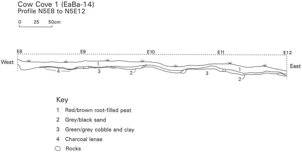
The stratigraphy of Cow Cove 1 consists of four basic layers (Figure 2). The ground surface is comprised of a 5 to 20 cm layer of forest litter and red/brown peat which overlays a two to three centimetre thick cultural layer consisting of a grey/black sandy matrix. Large water worn greenish-grey cobbles held in a similarly coloured clay stratum underlay the cultural layer and represent the original beach surface on which the occupation was situated. Below the cobble beach is sterile compacted reddish-brown sandy-gravel subsoil. The soil profile of the site illustrates that the cultural layer is very thin and undisturbed, suggesting that this site was likely not reoccupied over time, nor was reoccupied by later cultures, prehistoric or otherwise.
Figure 1
Location plan
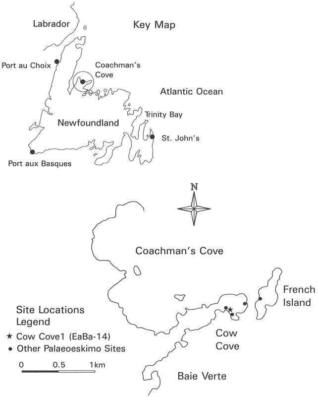
Figure 2
Cow Cove 1: Soil profile
Site features
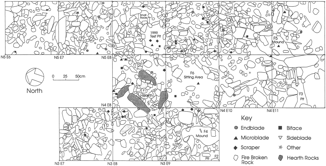
As illustrated in the plan view of the main excavation area (Figure 3), the ancient cobble beach of Cow Cove has been altered through the construction and use of a hearth that is located in unit N4E8. This feature measures approximately 50 cm by 75 cm in size and is comprised of four partially upright stone slabs. These stones are embedded into the greenish-grey clay and enclose fire-cracked rock and sparsely scattered charcoal remains. The alignment of the hearth, at an angle of approximately 45 degrees to the shoreline, and the lack of accompanying architectural features, such as paving stones, walls, or hold down stones, suggest that the Cow Cove 1 hearth is an isolated structure. In form, the hearth is similar to the isolated box hearths found at the Postville Pentecostal site (GfBw-4) in Labrador. In comparison to the more substantial flagstone paved house structures at the Postville site, it was postulated that these kinds of isolated hearth features might be representative of a different seasonal occupation (Loring and Cox 1986: 69). In view of the similarities between the box hearths from Postville and Cow Cove, it is proposed that the Cow Cove 1 feature may have been part of a warm season structure, or simply, an outdoor hearth.
However, due to the limited nature of the Cow Cove excavation area, the hearth could be part of a larger and more complex habitation sequence that has yet to be uncovered. This seems a reasonable possibility, owing to the fact that the site of Cow Cove 1 is also relatively rich in lithics, as compared to other short term Early Palaeoeskimo occupations in Labrador and the High Arctic. Alternatively, the artifact and flake distributions derived from the 1999 testing of the site indicate significantly lower frequencies outside the main excavation area. These results indicate that the hearth was the focal point of site activity, and that the surrounding areas are unlikely to contain similar architectural features. Further excavations are ultimately required to determine if there are additional habitation features at Cow Cove 1.
The concentration of large numbers of flakes and artifacts immediately adjacent the hearth, and the virtual absence of this material within the feature, suggest that there was little post depositional disturbance or long term re-use of this feature. In addition to the hearth, five less formal features were identified within the excavated area. Two of these features are 10 to 15 cm deep pits that are located in units N3E9 and N4E11 (Figure 3). Each of these features contained a mix of charcoal, black organic material, burned fat, a few waste flakes, and a single scraper (Erwin 2000: 9). Two other features located in units N3E9 and N5E11 consist of mounds of greenish-grey subsurface material. Their composition and close proximity to the aforementioned features suggests that the mounds were comprised of materials that originated from these pits. While the pit features might be identified as refuse areas relative to some processing task, the existing evidence precludes further identification of their function at this time.
The fifth feature, located adjacent the hearth in unit N4E9, is a small level compacted area of greenish-grey subsoil that has been cleared of the beach cobbles. This area is slightly elevated and is approximately 1 m by 0.5 m in size. The surface of this feature is practically void of any cultural material and is interpreted as a sitting and/or sleeping area that may have been covered with boughs and animal hides that kept debris from accumulating. Evidence for a comparable area on the opposite side of the hearth cannot be confirmed due to the presence of a mature tree in unit N4E7.
Figure 3
Cow Cove 1: Plan view
Artifacts
As summarized in Table 1, a total of 77 artifacts were recovered from the Cow Cove 1 excavations. A representative sample of these artifacts is illustrated in Figure 4. The artifact assemblage is comprised of approximately an equal number of endblades, microblades, scrapers and bifaces, suggesting that this site was probably not a special purpose camp, but rather a place where a variety of activities took place. Further, the concentration of these artifacts around the hearth (Figure 3) is an indication of an activity area that was not significantly affected by reoccupation or post-depositional disturbances.
The spatial distribution of artifacts by type also supports the presence of functional areas within the site. In particular, processing activities may be represented by the greater number of scrapers on the south side of the hearth in units N3E7 and N3E8, and the number of microblades northeast of the hearth. Upon examination of the other two major categories of artifacts, endblades and bifaces, there does not appear to be a comparable discreetness in their patterning. It is noted, however, that the recognition of patterning is partially related to the amount of excavated area. As such, additional patterns may emerge with further excavation of the site.
Table 1
Cow Cove 1 artifact summary

Flakes
As indicated in Table 2, a total of 4,671 flakes were recovered from the 2000 excavation of Cow Cove 1. Of this total, 2,684 (58%) are chert; 895 (19%) chalcedony; 719 (15%) siltstone; 305 (7%) rhyolite; and 68 (1%) other types of raw materials. More specifically, the chert flake assemblage is predominantly comprised of fine-grained materials in a variety of colours. The chalcedony flakes are largely fine-grained and translucent grey in colour. The siltstone flakes are a purple-banded fine-grained material, and the rhyolite flakes, a coarse purplish-grey speckled material. In general, this lithic assemblage is comprised of high quality multi-coloured materials that are representative of Groswater raw material use, and more particularly, consistent with sites on the east coast of Newfoundland, where siltstone and rhyolite are locally available (Erwin 2000:18).
Figure 4
Cow Cove 1: Artifacts
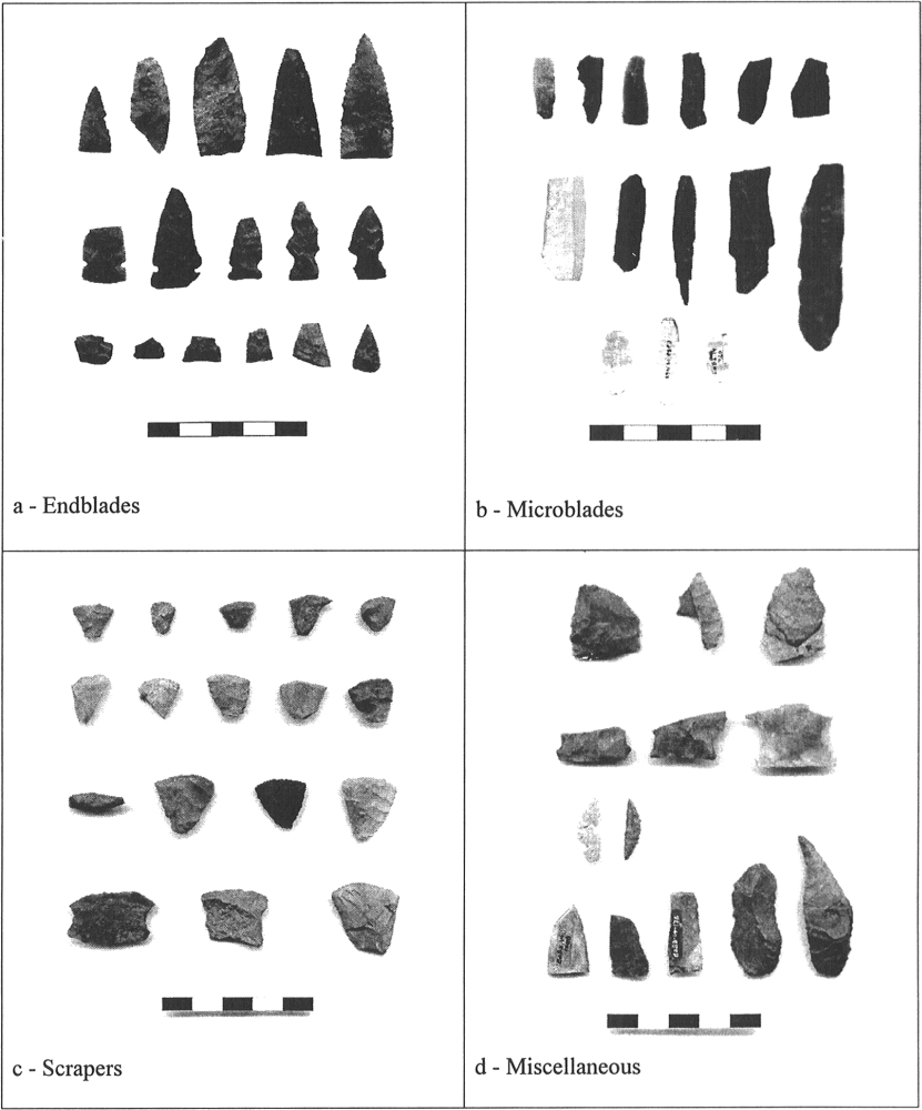
Table 2
Flakes by material type summary

* Total is based upon 2000 excavation, and does not include 1999 testing.
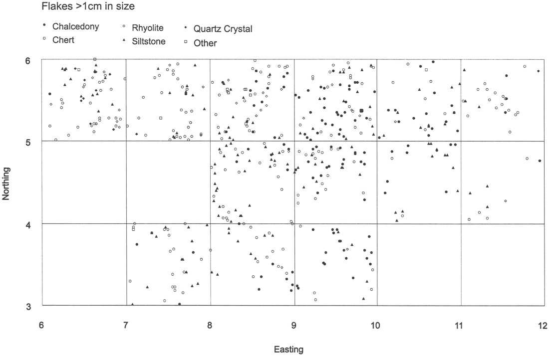
The spatial distribution of flakes, as illustrated in Figure 5, indicates that the vast majority of lithic reduction activities took place northeast of the hearth. From a comparison of flakes by material type, there appears to be some patterning which may also serve to identify lithic reduction areas. For example, 98% of the 137 waste chalcedony flakes that are greater than 1 cm in size are located east of the hearth. Of the 305 purple rhyolite flakes recovered, 60% (N=183) were recovered from a test area located outside the main excavation in the far northwest portion of the site. Although the chert and banded siltstone are generally more evenly dispersed across the main excavation area, the patterning of flakes by material type is indicative of single events during a short-term occupation, in which debris was not re-disturbed by a later use of the site.
Seasonality and resource use
The lack of any preserved faunal remains from Cow Cove 1 makes an assessment of seasonality and resource use speculative at best. As such, models for site location, resource availability and architecture may be employed as indicators for determining these aspects of the occupation. While existing resources can be used as a gross indicator for the range of possible resources, the recent recovery of faunal remains from the adjacent Dorset Palaeoeskimo site of Cow Cove 3 (Erwin 2003) may provide a more accurate indicator of resource availability. A cursory identification of the faunal assemblage (N=210) indicates the presence of significant amounts of fish and bird bone (Cogswell 2002). While it is obvious that seasonality cannot be directly inferred for the Groswater occupation of Cow Cove from the Dorset use of this locality, the faunal assemblage does serve to indicate the availability and use of these types of resources at this location prior to 1200 B.P.
Figure 5
Cow Cove 1: Flake distribution
Despite the limitations of estimating seasonality from architectural remains (e.g., Park 1988; Nagy 1994), seasonal indicators have often included elements of house design, complexity, permanence, and the quantity and types of artifacts found in association with habitation structures. In view of the excellent preservation of the features and the discreet nature of the distribution of the artifact assemblage, it would appear that Cow Cove was a warm weather Groswater occupation on the basis of: 1) the presence of an isolated hearth feature; 2) the location of the site relative to the types of known available warm weather resources, and 3) the protected nature and orientation of the site. While the migrating harp seals in White Bay would occasionally be accessible from Cow Cove, there are more exposed locations in the region that would have provided considerably better access to this resource. The views and access from Cow Cove 1 are limited by the southern orientation of the site towards the bottom of Baie Verte, and the location of the site between two rock outcrops. Conversely, these rock outcrops could have been used as blinds for bird hunting. Considering the great number of birds that seasonally inhabit this peninsula and the nearby islands, and the presence of bird bones from the adjacent Dorset occupation, Cow Cove 1 appears well suited as a warm weather habitation site.
Conclusions
The archaeological assemblage of Cow Cove 1 suggests a short-term single component warm weather Groswater occupation that is consistent with the highly mobile seasonal round that Groswater hunter-gatherers have been accorded. The discreetness of the spatial distribution of lithic debitage and artifacts relative to the limited architectural remains provides evidence that the site is relatively uncomplicated by post-depositional disturbances or re-use. The presence of a box hearth and the lack of additional permanent architectural features suggest that Cow Cove 1 contained a relatively informal and lightly constructed warm weather structure. The sheltered nature of the site, and its orientation away from open sea, further suggest a warm weather occupation of the site.
Finally, this examination of the architectural features of Cow Cove 1 has benefited from perspectives which incorporate elements of site location, season of use and site orientation. By considering these elements in concert with the architectural features, a greater understanding of site function was achieved. These findings advance Cow Cove 1 as a model that may be used for the identification, comparison and interpretation of other warm season Groswater sites.
Parties annexes
Acknowledgements
Research for this paper was supported by the Institute of Social and Economic Research, Memorial University; the Social Science and Humanities Research Council of Canada; the Dorset Soapstone Carving Committee of the Town of Fleur de Lys; the Provincial Archaeology Office of the Government of Newfoundland and Labrador; the Department of Archaeology of the University of Calgary; the University of Calgary Office of Research; and the Newfoundland Archaeological Heritage Outreach Program. Thank you to Sylvie LeBlanc and Murielle Nagy for the invitation to participate in the "Palaeoeskimo Architecture: State of Knowledge" symposium of September 2002 for which this paper was originally written. Finally, I would like to thank the two anonymous reviewers for their comments and helpful suggestions.
References
- COGSWELL, Ainslie, 2002 A Faunal Analysis of a Middle Dorset Site at Cow Cove 3, unpublished paper prepared for Anthropology 3585/86, St. John's, Memorial University of Newfoundland, Archaeological Field School.
- DEVEREUX, Helen E., 1966 The Cape Ray Light Sit, unpublished report on file, Gatineau, Canadian Museum of Civilization, Archaeological Survey of Canada.
- ERWIN, John C., 1995 An Intrasite Analysis of Phillip's Garden: A Middle Dorset Palaeo-Eskimo Site at Port au Choix, Newfoundland, M.A. thesis, St. John's, Memorial University of Newfoundland, Department of Anthropology.
- ERWIN, John C., 1999 Final Report for the 1999 Field Season: Fleur de Lys Archaeological Project, unpublished report on file, St. John's, Government of Newfoundland and Labrador, Department of Tourism, Culture and Recreation, Culture and Heritage Division.
- ERWIN, John C., 2000 Final Report for the 2000 Field Season, Fleur de Lys Archaeological Project, unpublished report on file, St. John's, Government of Newfoundland and Labrador, Provincial Archaeology Office.
- ERWIN, John C., 2001 A Prehistoric Soapstone Quarry in Fleur de Lys, Newfoundland, Ph.D. dissertation, Calgary, University of Calgary.
- ERWIN, John C., 2003 Interim Report for the 2002 Field School, The Cow Cove Excavations, unpublished report on file, St. John's, Government of Newfoundland and Labrador, Provincial Archaeology Office.
- EVANS, Clifford O., 1981 1980 Field Report of Frenchman's Island Project, Archaeology in Newfoundland and Labrador 1980, Annual Report 1, in J.S. Thomson and B. Ransom (eds), St. John's, Government of Newfoundland and Labrador, Department of Culture, Recreation and Youth, Historic Resources Division: 88-94.
- FOGT, Lisa M., 1998 The Excavation and Analysis of a Dorset Palaeoeskimo Dwelling at Cape Ray, Newfoundland, M.A. thesis, St. John's, Memorial University of Newfoundland, Department of Anthropology.
- HARP, Elmer Jr., 1964 The Cultural Affinities of the Newfoundland Dorset Eskimo, Ottawa, National Museum of Canada Bulletin, 200.
- HARP, Elmer Jr., 1976 Dorset Settlement Patterns in Newfoundland and Southeastern Hudson Bay, in M.S. Maxwell (ed.), Eastern Arctic Prehistory: Palaeoeskimo Problems, Washington, Memoirs of the Society for American Archaeology, 31: 119-138.
- HUNTER-ANDERSON, Rosalind L., 1977 A Theoretical Approach to the Study of House Form, in L.R. Binford (ed.), For Theory Building in Archaeology, New York, Academic Press: 287-315.
- JENSEN, Jens F., 1993 Intrasite Analysis of Palaeo-Eskimo Campsites, M.A. thesis, Copenhagen, University of Copenhagen, Institut for Forhistorisk og Klassisk Arkaeologi.
- KENNETT, Brenda L., 1990 Phillip's Garden East: A New Perspective on Groswater Palaeoeskimo, M.A. Thesis, St. John's, Memorial University of Newfoundland, Department of Anthropology.
- LeBLANC, Sylvie, 1997 Dildo Island Archaeological Project: The Dorset Occupation of Dildo Island Preliminary Field Report — 1996, St. John's, Government of Newfoundland and Labrador, Department of Tourism, Culture and Recreation, Historic Resources Division.
- LINNAMAE, Urve, 1975 The Dorset Culture: A Comparative Study in Newfoundlandand the Arctic, St. John's, Technical Papers of the Newfoundland Museum, 1.
- LORING, Stephen and Steven COX, 1986 The Postville Pentecoastal Jroswater Site, Kaipokok Bay, Labrador, in Palaeo-Eskimo Cultures in Newfoundland, Labrador and Ungava, St. John's, Memorial University of Newfoundland, Reports in Archaeology, 1.
- MURRAY, Maribeth S., 1992 Beyond the Laundry List: The Analysis of FaunalRemains from a Dorset Dwelling at Phillip's Garden(EeBi-1), Port au Choix, M.A. thesis, St. John's, Memorial University of Newfoundland, Department of Anthropology.
- NAGY, Murielle I., 1994 Interpretation in Arctic Archaeology: Lessons From Inuvialuit Oral History, Bridges Across Time: The NOGAP Archaeology Project, Canadian Archaeological Association, Occasional Paper, 2: 29-38.
- PARK, Robert W., 1988 "Winter Houses" and Qarmat in Thule and Historic Inuit Settlement Patterns: Some Implications for Thule Studies, Canadian Journal of Archaeology, 12: 163-175.
- RENOUF, M.A. Priscilla, 1985 Archaeology of the Port au Choix National Historic Park: Report of 1984 Field Activities, unpublished report on file, Halifax, Parks Canada, Atlantic Region, Historic Resources Research.
- RENOUF, M.A. Priscilla, 1986 Archaeological Investigations at Phillip's Garden and Point Riche, Port au Choix National Historic Park: Report of 1985 Field Activities, unpublished report on file, Halifax, Parks Canada, Atlantic Region, Historic Resources Branch
- RENOUF, M.A. Priscilla, 1987 Archaeological Investigations at the Port au Choix National Historic Park: Report of 1986 Field Activities, unpublished report on file, Halifax, Parks Canada, Atlantic Region, Historic Resources Branch.
- RENOUF, M.A. Priscilla, 1991 Archaeological Investigations at the Port au Choix National Historic Park; Report of the 1990 Field Season, unpublished report on file, Halifax, Canadian Parks Service, Atlantic Region, Archaeology.
- RENOUF, M.A. Priscilla, 1992 The 1991 Field Season, Port au Choix National Historic Park: Report of Archaeological Excavations, unpublished report on file, Parks Canada, Atlantic Region, Archaeology.
- RENOUF, M.A. Priscilla, 1993 The 1992 Field Season, Port au Choix National Historic Park: Report of Archaeological Excavations, unpublished report on file, Halifax, Atlantic Region Parks Canada, Archaeology.
- ROBBINS, Douglas T., 1985 Stock Cove, Trinity Bay: the Dorset Eskimo Occupation of Newfoundland from a Southeastern Perspective, M.A. thesis, St. John's, Memorial University of Newfoundland, Department of Anthropology.
Liste des figures
Figure 1
Location plan
Figure 2
Cow Cove 1: Soil profile
Figure 3
Cow Cove 1: Plan view
Figure 4
Cow Cove 1: Artifacts
Figure 5
Cow Cove 1: Flake distribution
Liste des tableaux
Table 1
Cow Cove 1 artifact summary
Table 2
Flakes by material type summary
* Total is based upon 2000 excavation, and does not include 1999 testing.