
Résumés
Abstract
In this essay, we discuss housing policy in Nuuk (Greenland), which is characterised by disparity, undemocratic decision-making, and lack of open, frank discussion. Greenland has a culture of conflict avoidance and reluctance to accept criticism, due to its small population and its cultural traditions. Moreover, the city council’s housing policy has to take both the affluent and the less well-off into consideration. The latter, however, find it harder to influence policy-making. At the Ilinniarfissuaq (Institute for Learning) in Nuuk, we want our future teachers to take part in the development of society and in public debates over social issues. They should in turn be able to teach their students to get involved and to take a stand in debates. But how can we help these future teachers develop a critical view of housing policy without feeling oppressed and powerless? We tried to solve this problem through a technical solution—a GIS program. This program forced our teacher trainees to take a position and express their opinions.
Résumé
Dans cet essai, nous discutons de la politique du logement à Nuuk (Groenland), qui se caractérise par une grande disparité, des prises de décisions non démocratiques et une absence de discussions franches et ouvertes. Il existe au Groenland une culture de l’évitement des conflits et de la réticence à accepter les critiques, qui tient à sa petite population et à ses traditions culturelles. En outre, la politique du logement du conseil municipal doit prendre en considération autant les gens aisés que les plus pauvres. Ces derniers, cependant, trouvent qu’il leur est difficile d’avoir une influence sur les décisions politiques. À l’Institut d’apprentissage Ilinniarfissuaq de Nuuk où nous formons des enseignants, nous voulons que ces derniers prennent part à l’avenir au développement de la société et aux débats publics sur les questions sociales. Ils devraient à leur tour être capables d’inculquer à leurs étudiants la façon de s’impliquer et de prendre parti dans un débat. Mais comment aider ces futurs enseignants à se forger leur propre opinion au sujet de la politique du logement sans qu’ils se sentent opprimés et impuissants? Nous avons tenté de résoudre ce problème au moyen d’une solution technique — un programme SIG. Ce programme a obligé nos futurs enseignants à prendre parti et à exprimer leur opinion.
Corps de l’article
Introduction
In a small community such as Greenland, with ca. 56,000 inhabitants, it can be difficult to respect and validate everyone’s democratic rights. This is particularly so for housing policy in Nuuk, which is characterised by disparity and lack of democracy. The poor have only limited power to influence urban planning. In addition, citizens are reluctant to criticise the Greenland government because it owns most of the housing and is also the major employer. Criticism of the government is not taken lightly and can result in the loss of one’s job and home, since many people are given housing as an employment benefit (Sermitsiaq 2012). In addition, other family members might be affected as well.
In principle, land is held in common in Greenland and as such has no market value (Samuelson and Nordhaus 1992: 737). It cannot be owned, and anyone can ask the communal authorities for the right to use a piece of land, a so-called land allotment. In reality, the situation is different in the capital Nuuk, which is experiencing substantial population growth and is officially home to 15,000 residents. Because many people fail to register upon arrival, the authorities do not know the actual total (Kommuneqarfik Sermersooq 2013). There is fierce competition for building lots, which differ greatly in desirability. Some have good locations and, more importantly, good views. It is a myth, though, that building lots are scarce in Nuuk (Anonymous 1998).
A great deal of housing is slated for construction near the city. There is normally high demand in Nuuk for lots on which private homes can be built. Land is assigned for such uses by random draw. This method has been much criticised among people in general, many of whom know some wealthy politician who ended up with a very attractive lot (Lester 2001). Whenever the nicer building lots are assigned, there have been insinuations of cheating and use of front men (Kristensen 2011: 19).
The public building authority (i.e. the Self-Government of Greenland) and Sermersooq Municipality (the former Nuuk Municipality) are responsible for most of the rental construction. Such construction is awarded through tenders to private contractors. Once a house has been built, it can then be owned, and no one else has the option of using that land. Thus, a piece of land that was formerly owned as a common public good becomes a private good to be bought or sold. There has been much speculation in the Nuuk housing market, and profits have been and remain very high. Among the most discussed major building projects of recent years is the renovation and razing of the apartment buildings in Tuapannguit, in the city centre, and the construction of apartment towers in the new urban quarter of Qinnqorput.
At the Ilinniarfissuaq (Institute for Learning)[1] in Nuuk, we want our future teachers to take part in the development of society and in public debates. They should in turn be able to teach their students to participate and take a stand in society. In this paper we will discuss some aspects of Nuuk housing policy, and how we got our teacher trainees to discuss and think them over. To encourage their participation in debates on housing policy, we asked them to work with a GIS program. That way they would feel they were working to solve a technical problem, while actually considering the social aspects of housing policy.
Home Rule and Self-Government in Greenland
Greenland’s colonial status was changed in 1935 when it became a county (administrative district) with a special status. The period 1953-1979 saw very strong growth in the public sector, but nothing comparable in the private sector. Even today, State-owned corporations account for a very large part of Greenland’s trade and industry (Jakobsen 2008: 136). In 1979, Greenland was given Home Rule and became part of the Kingdom of Denmark, a federation of Denmark, Greenland, and the Faeroe Islands. Home Rule empowered the Greenlandic parliament to take over fields of jurisdiction that the Danish state had formerly administered and paid for on its own, and this new set-up would now be paid for by block grants from the Danish state (Harhof 1983: 112, 116). This funding would be administered solely by Greenland (Paldam 1994: 16). It would increase whenever the Home Rule government took responsibility for a new field (so-called “home taking”), initially the school system, church affairs, taxation, and so on. In 1987, the Home Rule government took over the housing industry (Skjelbo 1995: 74).
In 2008 a referendum on self-government was held in Greenland, and a majority voted in favour. Self-government was adopted the following year. The Self-Government Act included several key points: the Greenlandic people’s right to opt out of the Kingdom of Denmark; Greenland’s rights to its own resources; and a halt to increases in block grants. Housing policy was not central to discussion of self-government, having already been transferred to the Greenlandic government and incorporated into the former Home Rule regime. That policy area thus saw no changes (Nanoq n.d.).
Public debates in Greenland
Citizens can participate in a democracy to the extent that they may participate and express themselves in public debates. In his “discourse ethics” the philosopher Habermas lists five prerequisites to be met if participants in a discussion are to obtain validity and truth. Flyvbjerg summarises them below:
(1) no party affected by what is being discussed should be excluded from the discourse (the requirement of generality); (2) all participants should have equal possibility to present and criticize validity claims in the process of discourse (autonomy); (3) participants must be willing and able to empathize with each other’s validity claims (ideal role taking); (4) existing power differences between participants must be neutralized such that these differences have no effect on the creation of consensus (power-neutrality); and (5) participants must openly explain their goals and intentions, and in this connection desist from strategic action (transparence).
Flyvbjerg 1998: 213
As specified by Habermas, special interests must be reconcilable to ensure that participants are open to whatever arguments are presented to them. With debate over housing, the interests are hardly irreconcilable, but one can certainly question the veracity of some statements by the Home Rule and Self-Government authorities (Kristensen 2009a: 19).
All participants should also be financially independent and have a certain level of education, thereby ensuring that discussion is free of domination, i.e. discourse in which no one party can dominate another, and where each participant can freely defend his or her position (Sørensen and Hyltoft: 2012). This requirement is hard to meet in Greenland. Many participants may be vulnerable because the government decides where they shall live, what job opportunities they have, and so on. In Greenland, criticism is not generally accepted because of the country’s small population and cultural traditions (Gedionsen et al. 2006: 146). And, as we have pointed out, it is not without some danger if done in public. In a small society such as Greenland’s, citizens have limited access to local information through the media. There is a national government-funded television channel. There are also two newspapers, Sermitsiaq and AG (Atuagalliutit/Grønlandsposten), which come out respectively once and twice a week. In addition, in Nuuk a free weekly is owned by one of the above newspapers. The press is independent in principle but in practice not always so. It is difficult for citizens to bring a subject up and to keep the debate going in the press. Hence, only a limited number of individuals get their opinions printed in the newspapers.
In the media, the urbanisation of Greenland is often framed as a dichotomy, i.e. the settlements versus Nuuk. Media discussion also pits Greenland against Denmark in the sense that real Greenlanders are equated with those who had lived in the settlements that the Danish government destroyed. Urban development is thus difficult to discuss (Balstrøm et al. 2006: 561).
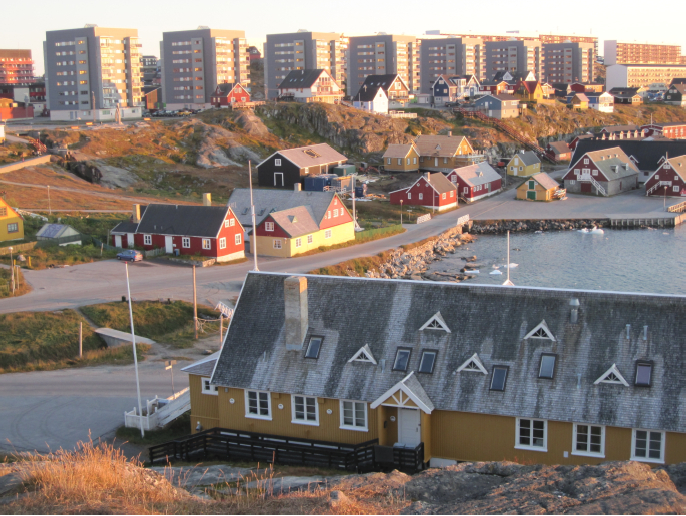
Early construction in Tuapannguit
Tuapannguit is very centrally located with four large apartment complexes built in 1966-1967, i.e. buildings Q, R, S, and T (Madsen 2000: 21). The apartments were very rundown due to lack of maintenance, although the property was very valuable because of the great view over the fjord (Figure 1). After renovating building T, the Home Rule authorities decided to raze the remaining three buildings. Buildings R and S were torn down, and the rubble dumped into the fjord off the Admiralty Islands in Malene Bay just outside Nuuk, a total of 1,000 m3 of waste with high PCB content, which will remain a serious source of pollution until it is removed. As the trade magazine Engineer pointed out, those old apartment buildings are, in a sense, making their way onto dinner tables in Nuuk. When the last building was demolished, the rubble was thus shipped to Denmark for recycling (Brogaard 2009).
Figure 1
The former apartment buildings in Tuapannguit, Nuuk.

Neighbourhoods cannot be precisely defined in terms of average income because income tax records are not compiled by neighbourhood or street address (Taxation authorities, pers. comm. 2011), but the original Tuapannguit tenants were probably of middle to low income. Building T was renovated, while buildings Q, R, and S were replaced with seven new apartment towers, three of which were sold as cooperative apartment buildings (Figures 2 and 3). Out of the original 184 rental apartments in the old apartment complex, 29 were converted into cooperative apartments, which the original tenants could not afford to purchase, even though the buildings were touted as “an apartment complex where an SIK family (a family with two low-wage incomes) could afford to buy a cooperative apartment” (Kristensen 2009a: 19).
The new tower blocks in Tuapannguit have ample parking space but rather limited play areas behind the gabions. The apartments in the previous complex all faced Godthåb Fjord. Half of them now face the hills. The cooperative apartments were immediately turned into condos and sold at a large profit. Three towers were reserved for Self-Government employees.
Figure 2
A retouched panoramic view of the housing plan for Tuapannguit.

Note the distance between the towers. This was how the buildings were presented to the politicians.
Figure 3
Tuapannguit’ s new apartments, Nuuk, 2011.
The last of the three towers was not marketed as a cooperative apartment complex. The Home Rule authorities also imposed very stringent requirements on prospective tenants with respect to their ability to pay rent. A tenant must not have been in arrears to the INI, the government housing corporation, during the previous three years. A first-time renter must also pay a six-month deposit that cannot be paid in instalments, in contrast to the practice of other rental apartments, which require only a three-month deposit to be paid over 12 months if one so wishes. A petition against this requirement gathered 1,317 signatures. According to Jens B. Frederiksen, the Home Rule Minister of Housing, Infrastructure, and Traffic, this requirement was established because “the renters wanted to guarantee nice surroundings, and peace and quiet in the neighbourhood” (Kristensen 2009b: 19, our translation).
Many of the previous tenants were thus unable to move into the new housing. The rental requirements refer implicitly to a certain value system. Can we expect better behaviour from tenants with higher incomes than from those with lower incomes? In addition, what does this say about a population with a particularly skewed income distribution? Greenland has a Gini coefficient of 0.33, in contrast to 0.23 for Denmark, and therefore has Scandinavia’s most skewed income distribution (Nanoq n.d.).
The new Pinngorsuaq towers in Qinnqorput
In February 2010, the city council adopted a local plan for construction of 10 tower blocks, each with 30 apartments in the new urban district of Pinngorsuaq in Qinnqorput. This large construction project was part of a plan by the Home Rule authorities to tear down several large apartment complexes in the central city, beginning with Block P, built in 1965 (Madsen 2000: 21) and encompassing 135 apartments (Figure 4). The authorities do not know precisely how many people lived in Block P which is now cleared of its tenants (Sermitsiaq 2010b). The tenants were primarily of middle to low income (Iglebaek 2011). Block P is often cited as an example of the failure of Danish housing policy in the 1960s and the arrogant exercise of colonial power over the subject population (Boisen and Nielsen 1996: 77). The razing of Block P has markedly changed the microclimate on the south side of the city. Positioned as it was across the direction of the prevailing winds, it significantly sheltered the other buildings from the cold northerlies. Today Block P is history, and children play where it once stood (Figure 5). But the social problems it represented still exist.
In 2011, this subject aroused the interest of two students at the Design School of the Royal Danish Art Academy in Copenhagen, Matylda Rasmussen and Sarah Bodil Hansen. For their M.A. thesis, they gathered stories by residents from the soon-to-be-demolished Block P (Imagined Space n.d.). These decrepit downtown apartments should not be romanticised, but the tenants still deserve respect. There was life in Block P for better or for worse, and the lives and concerns of its residents will not disappear once the buildings have been razed, although their stories may easily be forgotten (ibid.).
Figure 4
Block P, when it was being cleared of residents, Nuuk, 2011.

Figure 5
Original location of Block P, Nuuk, 2013.

Block P exemplified the modernist architectural style that prevailed at the time, which sought to isolate urban activities from each other while emphasising individual building structures. Using the apartment complexes in Nuuk as an example, urban planning researcher Jan Gehl describes modernism in this way:
Modernists rejected the city and the city space, shifting their focus to individual buildings. This ideology had become dominant by 1960, and its principles continue to affect the planning of many new urban areas. If a team of planners was asked to radically reduce the scope of life between buildings, they could not find a more effective method than using modernistic planning principles (Gehl 2010: 4).
Another key planning principle for modernists was equal access to housing. People have universal needs, and therefore housing must meet those needs without discrimination. Unfortunately, housing has thus become very uniform. In an apartment complex, either everyone has a balcony or nobody has one, and just because an apartment is on the ground floor does not mean that it should have access to a veranda, as that would be unfair to the other tenants (Bech-Danielsen 2004: 76-77). This principle has been followed consistently throughout the apartment complexes in Nuuk.
As a guideline for more modern urban planning, Gehl (2010: 6-7) established four requirements:
A lively city, where the residents can congregate in the city spaces.
A safe city. A city seems safer when many people frequent and congregate in the city spaces. A city that is inviting to walk in must also have a coherent structure that provides short walking distances, attractive spatial experiences, and a suitable variation of urban structures.
A sustainable city. The sustainable city is strengthened if a large part of the transport system can occur as “green mobility,” that is travel by foot, bike, or public transport.
A healthy city. It should be easy for residents to move about in the city, and the environment should be attractive as a destination for walks, etc.
A city also has democratic requirements. It must allow people to meet each other and see each other, even those who do not live on the same street (ibid.: 157). As an example of cities that fail to meet these requirements, one can look at South African cities under apartheid. By dividing cities up by race and placing blacks out in townships, the authorities ensured that whites did not have to see them. Physical planning was thus integral to the apartheid mentality (Diercke 1992: 132).
The 10 new apartment complexes in Qinnqorput are in two rows that run parallel to the Great Malene Range, the two mountains that overlook Nuuk (Figure 6). The site will probably remain on the city’s outskirts for some time. Because the apartments face northwest and are in the shadow of the mountains for part of the winter, the area is noticeably colder than other areas closer to the bay. Will the colder climate result in higher energy consumption? In answer to a question put to the city council, the architectural firm responsible for the buildings replied that the complexes were positioned for optimum solar gain (Kommuneqarfik Sermersooq 2010b: 71), but this statement probably does not apply to the lowest apartments. The teacher trainees discussed this issue in light of Gehl’s (2010) ideas about a sustainable city.
Figure 6
The new Qinqorput, Nuuk, 2013.

The apartment complexes have differently coloured trimmings and are divided into three areas, although the basic structures are all grey. There are some minor variations between the complexes, with some having bay windows and others not.
The entryways of the Qinnqorput buildings are at ground-floor level and face southwest. They are recessed about two metres from the front side to give protection from the weather. They are in the lee of winds from the southeast and south, and of course from the northerlies. The entryways face a bright, sunlit square that looks inviting and encourages the residents to spend time there and talk with neighbours. This is something that Kommuneqarfik Sermersooq has also prioritised in its own housing projects in Akunnerit and Pisissia.
Kommuneqarfik Sermersooq 2010b: 72, our translation
The teacher trainees determined whether or not the buildings’ entryways (Figure 7) meet this requirement, with reference to a basic principle of urban planning: “Quite simply, good cities for staying have rough facades and good support points. In contrast, cities without edges or with smooth building facades devoid of detail have little to offer in terms of ‘staying psychology.’ People needing to stay for any length of time in city space find it tiring to stand, and will look about for somewhere to sit” (Gehl 2010: 139-140).
Figure 7
The entryways of the Qinnqorput buildings, Nuuk, 2013.

According to the Sermersooq Municipality, the outdoor space may be planned as follows:
As the area had previously been a quarry, the original vegetation had been destroyed, except for two protected knolls. The area looks like a desert. One suggestion, based on Japanese landscape gardening, is to create an exciting and varied outdoor space. This can be done by creating areas with rock gardens, using stones of different sizes and shapes, and erecting windbreaks with gabions that can provide a bed for vegetation and give shelter from the wind when one is outdoors.
Kommuneqarfik Sermersooq 2010a: 6, our translation
Gabions are low walls made by filling galvanised mesh cages with small stones. They can be seen between the Tuapannguit and Qinnqorput buildings. The Qinnqorput site is surrounded by stony desert because explosives were used to level the hills when construction began. The area is quite cold and will probably be difficult to re-vegetate by natural means. If plant cover is added, this task will require much effort and use of suitable landscaping.
But the surroundings are not only physical in nature. This point is exemplified by another project planned for the city centre (Kommuneqarfik Sermersooq 2012). Interestingly, but also depressingly, the lessons of the past have been ignored. This housing project lacks the amenities a housing project needs. The same problem existed when block housing started in Greenland, and it is still with us (Steenfos and Taagholt 2012: 330).
Objections to the Qinnqorput towers
Two architects have criticised the Qinnqorput towers. As one of them, Thomas Riis, put it:
[…] There are no places to sit in private, sit together in shelter from the wind, or to play; in this dystopia of a Soviet coal-mining town from the 50s, there is literally no ‘place’ at all. […] The planned building design, erected in the shadow of Ukusissat, will mean that half of the almost 1,000 residents will be denied sunshine and warmth during the winter months. From the perspective of energy and the environment, it’s crazy, and it represents a warped view of people that is far from the city council’s expressions of humanity, respect, and care.
Kommuneqarfik Sermersooq 2010b: 72, our translation
The architect Peter Barfoed voiced the following objections, based in particular on energy concerns: “Residential quality, city spaces, and architectural quality seem to have evaporated in the municipal demands on the design of new residential areas […]. A basic rule with regard to building in an Arctic climate is to site the building with some regard to sun and wind, as well as ensuring a view” (Kommuneqarfik Sermersooq 2010b: 71, our translation). Barfoed pointed to the low energy efficiency due to the building being located in a shadow. The objections were not taken seriously, however, and the board chair, Olafur P. Nielsen, who is the Greenland government representative for large building plans, said that the architects were dissatisfied because they had not been awarded the contract. “Sour grapes” was his answer (Sermitsiaq 2010a). Criticism is therefore no longer possible, as the government is Greenland’s largest entrepreneur. You do not dare bite the hand that feeds you.
Using GIS and orthophotos for teaching
The use of new computer programs is not a teaching goal in itself. Technology can, however, be used to gain new knowledge or new perspectives on specific subjects. Our senses are dulled by everyday life, but new technologies can give us new perspectives. When teaching about housing issues, we want students to be aware of their surrounding urban landscape, which is usually taken as a given and not as something that can be discussed. GIS[2] is a series of computer programs that may be used to analyse and evaluate maps and data (Balstrøm et al. 2006: 13). The programs themselves contain no new data, but their power to integrate digitised data provides new potential for both research and education. As an example, we can look at the extensive ongoing research on the melting ice caps and icebergs in the Arctic and Antarctic, which to a great degree is based on satellite surveillance. This information is converted into digital maps that can reveal the melt patterns in the ice, which would otherwise be difficult to discern simply because of the size of the areas under study. GIS offers new potential in other areas, i.e. cataloguing of buildings, archaeological sites, and other observations of natural occurrences. We wanted to use GIS with our teacher trainees to facilitate debate about housing issues.
Western school systems have shown increasing interest in GIS-based science instruction. For example, such instruction is compulsory in the Danish high school curriculum for geography. In Greenland, we have access to Nuna GIS, which is a government-controlled GIS database (Nuna GIS n.d.), and to the Inspire network, which is a European-Union-funded database with the objective of making GIS-based information available transnationally (Inspire n.d.). Today, several GIS programs are also available, including some designed for teaching. In our case, we chose to use the shareware program Quantum GIS (QGIS n.d.).
An orthophoto is an aerial photo that has been geometrically corrected to make the scale uniform and to depict ground features in their exact ground positions, with removal of all distortion caused by camera and flight characteristics and relief displacement. The orthophoto is then positioned in a coordinate system. Using a GIS program, buildings, roads, sewer systems, and so on can be drawn on the photo. In Figure 8 you can barely see the “seams” that show that the photo is a composite made from many photos taken during numerous flights. Our students were already familiar with orthophotos of the Nuuk area from Google Earth, which uses Asiaq’s orthophotos.
Applying the Quantum GIS program to housing issues in Nuuk
We asked a group of 13 students in the second level of teacher training to look at the urban development of Nuuk by using the Quantum GIS program. The program enabled them to try alternative positioning of the 20 x 20 metre buildings that make up the proposed apartment complexes in Qinnqorput. These positions were then compared with the ones that had already been chosen. For example, these buildings could be placed on lots reserved for government employees in Tuapannguit. The students had the power to play with reality and not just accept what they see on a daily basis.
The students were also able to position the tower blocks in groups and in different places along the bay front using Quantum GIS and Asiaq’s orthophotos of Nuuk. They then answered these questions:
Should the tower blocks be located in groups of seven or 10?
Measure the open areas between the blocks in the new Tuapannguit and Qinnqorput developments and compare the results with the open areas in other apartment complexes in the city. What should be included in open areas?
How can you ensure that the buildings meet the tenants’ needs for outdoor recreation?
If we assume that the 300 apartments have four residents per apartment, how much open space will there be between the blocks per resident?
What open spaces will different age groups and lifestyle groups require?
Figure 8
Orthophoto of Nuuk with roads and place names added.

The outcome
The students were studying “culture and social knowledge” as part of their curriculum. In the Greenlandic curriculum, “culture” matters more than “history.” The word “culture” describes the present and the past in all of the subjects taught, with social knowledge being seen as part of cultural knowledge. In Greenland there is a tendency to interpret this approach as something that distinguishes Greenland from Denmark (Langgård 2003: 229) and to look upon Greenlanders as being permanently victimised by the Danes (Kleemann 2013).
Afterwards the students had to answer a questionnaire about what they had learned and about their thoughts on urban development in Nuuk. We asked them to list the advantages and disadvantages of the building projects. We were given answers such as “it is nice to be able to take a walk around the buildings in an area that offers security and comfort” and “it creates more security and all the residents get more privacy.” Generally the students were impressed by the nice buildings. Most of them mentioned the problem that low-income families cannot afford the rent in Tuapannguit. But they saw those families as belonging to “the other half of the population” to which they do not belong. Indeed, most of the students looked upon themselves as future teachers and thus as affluent citizens. They wanted security and tranquillity above all for themselves.
So did the GIS exercise on Nuuk housing work? We can only answer with a partial yes. The students did not want to talk about the city’s social problems. The postcolonial context is omnipresent in Nuuk and nearly all discussions ended in the Greenlandic-Danish dichotomy, as did our attempt at involving students in rethinking of urban development.
Conclusion
In this paper we discussed housing issues in Nuuk and how citizens need to have a voice in public debate about such an important subject. Our intention was also to encourage our students at the Ilinniarfissuaq Teacher Training College to be curious and critical of urban development in Greenlandic society. With questions in mind that we could ask our students, we described the former buildings of the Tuapannguit area and Pinngorsuaq—the new Nuuk district in Qinngorput that will house many low-income families in the future. These housing projects have attractive locations in the city centre, which is now being modernised with a view to social “upgrading” of its inhabitants. We wanted to show that the proposal to transfer part of the low-income population to the city’s outskirts was not an inevitable solution.
We then provided our students at the Teacher Training College with tools to understand and discuss housing issues. Inspired by Gehl’s arguments for an urban quarter, we described how we wanted to teach our students to use the spatial dimensions of the Quantum GIS program to gather data about the new apartments in Nuuk and discuss the social implications. Use of this GIS program would thus create a platform for discussion by framing housing issues as being technological in origin, since the students did not readily think in terms of social problems. Although the students should have been able to take personal stands on social issues, they did not wish to do so. We still think that future teachers should be trained to focus on and analyse social problems, since they will be tomorrow’s makers of public opinion.
Parties annexes
Notes
-
[1]
Ilinniarfissuaq, formerly known as the Greenland Teacher Training College, was founded in 1845 and is one of Greenland’s oldest institutions (Ilinniarfissuaq n.d.). In 2008, it became the Institute for Learning at Ilisimatusarfik (University of Greenland). The main building was a landmark in the earlier Nuuk municipality. It was there that the country’s elite was educated, as were almost all of Greenland’s politicians who took part in the introduction of Home Rule.
-
[2]
GIS stands for “Geographic Information System.”
Parties annexes
Acknowledgments
We would like to thank the following for their help. The tools used in this study were first developed for fieldwork near Solheimajökull, Iceland, under the leadership of Birgit Strømsholm (Norsk Romsenter, Oslo). Karl Brix Zinglersen (Asiaq) supplied orthophotos of Greenland’s capital Nuuk and other maps. He also helped explain the workings of the free GIS-based program, Quantum GIS (QGIS). Viggo Liebmann Hansen (Ilisimatusarfik) delivered fast user support for those computer problems that inevitably occur.
References
- ANONYMOUS, 1998 Borgmesteren traekker lod om 40 byggegrunde i Nuuk (‘The mayor draws the winning numbers for 40 allotments in Nuuk’), Atuagalliutit/ Grønlandsposten, December 22: 5.
- ASIAQ (Greenland’s Geophysical Survey), n.d. Asiaq’s web site (http://www.asiaq.gl).
- BALSTRØM, Thomas, Ole JACOBI and Lars BODUM, 2006 Bogen om GIS og geodata (‘The Book about GIS and Geodata’), Copenhagen, Forlaget.
- BECH-DANIELSEN, Claus, 2004 Moderne arkitektur – hva’er meningen? (‘Modern Architecture – What’s the Meaning?’), Århus, Systime.
- BOISEN, Pia and Svend Erik NIELSEN, 1996 Grønland – kontrasternes land (‘Greenland – the Land of Contrasts’), Copenhagen, Gyldendal undervisning.
- BROGAARD, Marie, 2009 Grønland smed 1000 kubikmeter PCB-affald direkte i havet (‘Greenland threw 1,000 cubic metres of PCB-contaminated waste into the sea’), Ingeniøren, July 10 (online at: http://ing.dk/artikel/100045-groenland-smed-1000-kubikmeter-knust-pcb-affald-direkte-i-havet).
- DIERCKE, Bergundet Von C., 1992 Diercke Weltatlas (‘World Atlas’), Braunschweig, Westermann Verlag.
- FLYVBJERG, Bent, 1998 Habermas and Foucault: Thinkers for Civil Society, British Journal of Sociology, 49(2): 208-233.
- GEDIONSEN, Anders, Else SØNDERGAARD and Jane Buus SØRENSEN, 2006 Store forventninger (‘Great expectations’), in Jan Sjøberg and Sven-Erik Hansén (eds), Framtidens lärare, Vasa, Rapport från Pedagogsike fakulteten vid Åbo Akademi, 17: 139-149.
- GEHL, Jan, 2010 Cities for People, Washington, Island Press.
- HARHOF, Frederik, 1983 Rigsfaellesskabet (‘The Kingdom of Denmark’), Aarhus, Klim.
- IGLEBAeK, Odd, 2011 The dilemma of Block P, Journal of Norderio, 2 (online at: http://www.nordregio.se/en/Metameny/About-Nordregio/Journal-of-Nordregio/Journal-of-Nordregio-no-2-2011/The-dilemma-of-Blok-P/).
- ILINNIARFISSUAQ, n.d. Ilinniarfissuaq’s web site (www.ilinniarfissuaq.gl).
- IMAGINED SPACE, n.d. Blog of Imagined Space (http://www.imaginedblog.com).
- INSPIRE, n.d. Inspire’s web site (http://www.inspire-geoportal.eu).
- JAKOBSEN, Mads Leth Felsager, 2008 Et blindt focus på Danmark? En analyse af den grønlandske forvaltnings ideimport (‘A blind focus on Denmark? An analysis of the importing of ideas by the Greenlandic administration’), Politica, 40(2): 134-154.
- KLEEMANN, Louise M., 2013 Jeg har ikke nogen voldsdom (‘I don’t have a sentence for violence’), Atuagalliutit/Grønlandsposten, March, 27: 3.
- KOMMUNEQARFIK SERMERSOOQ, 2007 Lokalplan 1A17-1 (Tuapannguit) (online at: http://www.sermersooq.gl/da/borger/byplanlaegning/lokalplaner_og_kommuneplantillaeg/lokalplaner_og_kommuneplantillaeg_for_nuuk).
- KOMMUNEQARFIK SERMERSOOQ, 2007 2010a Lokalplan 4a5 (Pinngorsuaq, Qinnqorput) (online at: http://www.sermersooq.gl/da/borger/byplanlaegning/lokalplaner_og_kommuneplantillaeg/lokalplaner_og_kommuneplantillaeg_for_nuu).
- KOMMUNEQARFIK SERMERSOOQ, 2007 2010b Kommuneqarfik Sermersooq meeting, February 23, 2010 (online at: http://www.sermersooq.gl/media(3a663fc5-6ab9-4a6e-a)).
- KOMMUNEQARFIK SERMERSOOQ, 2012 Kommuneplantillaeg C30-1 (online at: www.sermersooq.glsermersooq.gl/da/borger/byplanlaegning/kommuneplantillaeg/lokalplaner_og_kommuneplantillaeg_for_nuuk).
- KOMMUNEQARFIK SERMERSOOQ, 2013 Kommuneqarfik Sermersooq’s home page on web site (http://www.sermersooq.gl/da/om_kommune/byer_og_bygder/nuuk).
- KRISTENSEN, Kurt, 2009a Landskassen forgylder bolighajerne i Nuuk (‘Landskassen makes golden days for the property sharks in Nuuk’),Nuuk Ugeavis, 31: 19.
- KRISTENSEN, Kurt, 2009b 1317 underskrifter gjort til grin (‘1,317 signatories made a laughing stock’), Nuuk Ugeavis, 46: 19.
- KRISTENSEN, Kurt, 2011 Lodtraekning åbner en ladeport for boligspekulanterne (‘Drawing lots opens the floodgates for property sharks’), Nuuk Ugeavis, 11: 19.
- LANGGÅRD, Karen, 2003 Magt og demokrati –og sprog (‘Power and democracy – and language’) in Gorm Winther, Demokarti og Magt i Grønland (‘Democracy and Power in Greenland’), Aarhus, Aarhus Universitetsforlag: 215-235.
- LESTER, Poul, 2001 Grønlands største bingo! (‘The biggest bingo in Greenland!’), Kamikposten, December 14 (online at: http://www.kamikposten.dk/global/maskinrum/rutine/leksikon.aspx?udvalgt=2001121404&folder=hvadermeningen&sprog=da&tag=alleartikler).
- MADSEN, Jens Kr., 2000 Nuuk/Godthaab, Nuuk and Godthaab, Atuagkat.
- NANOQ, n.d. The Government of Greenland’s web site (http://www.nanoq.gl).
- NUNA GIS, n.d. NunaGis’ web site (http://www.nunagis.gl).
- PALDAM, Martin, 1994 Grønlands økonomiske udvikling (‘The Economic Development of Greenland’), Aarhus, Aarhus Universitetsforlag.
- QGIS, n.d. QGIS’ web site: http://www.qgis.org.
- SAMUELSON, Paul A. and William D. NORDHAUS, 1992 Economics, New York, McGraw-Hill.
- SERMITSIAQ, 2010a Giftigheder i spil om stort byggeri (‘Heavy use of venom on the construction issue’), Sermisiaq, January 21 (online at: http://sermitsiaq.ag/node/72517).
- SERMITSIAQ, 2010b Blok P-beboere genhuses I Qinngorput, (‘Block P inhabitants rehoused in Qinngorput’) Sermisiaq, February 4 (online at: http://sermitsiaq.ag/node/72501).
- SERMITSIAQ, 2012 Peter Schultz stopper som departementschef (‘Peter Schultz quits as Permanent Secretary’), Sermisiaq, November 19 (online at: http://sermitsiaq.ag/node/140828q).
- SKJELBO, Per F., 1995 Så vender vi kajakken? (‘Now we turn the kayak?’), Aalborg, Aalborg Universitetsforlag.
- SØRENSEN, Bent Højgaard and Vibeke HYLTOFT, 2012 Kinesisk invasion truer Grønland, (‘Chinese invasion threatens Greenland’),Business Magasin, October 18 (online at: http://www.business.dk/global/kinesisk-invasion-truer-groenland).
- STEENFOS, Hans P. and Jørgen TAAGHOLT, 2012 Grønlands Teknologihistorie (‘The history of Greenlandic technology’), Copenhagen, Gyldendal.
Liste des figures
Figure 1
The former apartment buildings in Tuapannguit, Nuuk.
Figure 2
A retouched panoramic view of the housing plan for Tuapannguit.
Note the distance between the towers. This was how the buildings were presented to the politicians.
Figure 3
Tuapannguit’ s new apartments, Nuuk, 2011.
Figure 4
Block P, when it was being cleared of residents, Nuuk, 2011.
Figure 5
Original location of Block P, Nuuk, 2013.
Figure 6
The new Qinqorput, Nuuk, 2013.
Figure 7
The entryways of the Qinnqorput buildings, Nuuk, 2013.
Figure 8
Orthophoto of Nuuk with roads and place names added.