Résumés
Abstract
Based on ethnographic and oral history research, this article investigates community experiences of historical and contemporary mineral development in the Arctic through an analysis of the cultural landscape of Rankin Inlet, Nunavut. The town was established in the 1950s around the North Rankin Nickel Mine—Arctic Canada’s first industrial mining operation. The mine’s rapid closure in 1962 dealt a devastating blow to the local economy, with about half the community staying in Rankin Inlet and struggling to make a living. In spite of the long period since closure, the mine’s influence is still present in the town’s built environment and cultural landscapes. Our research seeks to reveal the symbolic attachments both Inuit and long-term Qallunaat residents have formed with the post-industrial landscape. We argue that Rankin Inlet, as a community, is coming to terms with and (re)staking its claims to its industrial past, as part of contemporary efforts to manage the costs and benefits of new mineral development in the region.
Résumé
À partir d’une recherche ethnographique et en histoire orale, cet article examine les expériences communautaires historiques et contemporaines du développement minier dans l’Arctique, au moyen d’une analyse du paysage culturel de Rankin Inlet au Nunavut. Ce village fut fondé dans les années 1950 à proximité de la première opération minière d’envergure industrielle au Canada, la North Rankin Nickel Mine. La fin brutale de ses activités, en 1962, porta un coup terrible à l’économie locale; le nombre des résidents de la communauté diminua de moitié, ceux qui restaient devant lutter pour survivre. Malgré la longue période qui s’est écoulée depuis la fermeture de la mine, l’influence de celle-ci se fait encore sentir dans l’environnement bâti du village et les paysages culturels. Notre recherche s’efforce de révéler les attachements symboliques que les habitants, tant Inuit que résidents qallunaat de longue date, ont noués avec le paysage postindustriel. Nous avons pour postulat que Rankin Inlet, en tant que communauté, reconnaît son passé industriel et recommence à le revendiquer, dans le contexte des efforts qu’elle fait actuellement pour gérer les coûts et les bénéfices d’un nouveau développement minier de la région.
Corps de l’article
Introduction
Mineral development can radically transform the environment and introduce new structures and symbols into the landscape. The residual landscapes and remnants that remain post-mining represent the inherent instability and finite life of mineral developments. Yet, even long after mining activity has ceased, these landscapes are not quite “dead,” often going through processes of both environmental reclamation and emotional regeneration as industrial heritage (Edensor 2005b; Stephenson and Wray 2005). Rather than a space of degradation and demise, over time the ruins of deindustrialisation may become incorporated into the multiple narratives and identities of the community. Cultural geographers have called for deeper engagement with the many subjective meanings that communities form with industrial ruins (Bridge 2004; Robertson 2006).
Through an analysis of the former North Rankin Nickel Mine in Rankin Inlet, Nunavut, we investigate how present-day community members interact with and experience the historical mining landscape. In exploring the personalised meanings that landscapes take on for various actors, including Inuit and non-Inuit, miners, families, and government officials, we describe industrial ruins as resources for identity making, and not as “dead history.” By engaging with the materiality of mined landscapes, the objects and images remaining, we seek to move beyond an account of the “impacts” of mine development and closure on northern communities (Boutet in press; Gibson and Klinck 2008). We instead move through the ruins, turning our attention to how community members are remembering and engaging mined landscapes in the performance of their place identities.
Rankin Inlet (Kangiqiniq, meaning ‘deep inlet’ in Inuktitut) is the only settlement in Nunavut founded by a mine.[1] The North Rankin Nickel Mine (NRNM), operated for only five years from 1957 to 1962, but, despite the mine’s short life and the long period since closure, the encounter with mining retains a powerful presence within the community. The NRNM was the first mine in Canada to employ Inuit workers, and it brought many Inuit families off the land and into the new settlement (Dailey and Dailey 1961; Williamson 1974). Over the life of the mine, Inuit comprised 70% of the total workforce, holding both surface and underground positions. Thus, the closure of the mine proved economically devastating to Rankin Inlet, prompting out-migration of southern workers and some Inuit, and fears of mass destitution (Boulter 2011; Williamson 1974). About half the community stayed post-closure, and various development projects were attempted to provide the remaining residents with alternative incomes, including ceramics and sewing projects, and various ultimately unsuccessful manufacturing endeavours (Jansen 1979). These projects, and the growth of Rankin Inlet as a regional administrative centre beginning in the 1970s, made the town the “hub” of the Kivalliq Region and a community with long-term Inuit and non-Inuit residents. Today, Rankin Inlet is the second-largest settlement in Nunavut, with over 2,300 inhabitants, 80% of whom are Inuit.
Fifty years after the closure of the NRNM, mining has returned to the Kivalliq Region. Agnico Eagle Mines (AEM) Ltd’s Meliadine gold project, located 25 km from Rankin Inlet, will soon follow the company’s Meadowbank gold mine, located near Baker Lake, which began operations in 2009 (Figure 1). The Meliadine project is predicted to be twice as big as Meadowbank, with twice the quality of gold reserves (Bell 2011). The mine is currently undergoing exploration and feasibility studies and is expected to start full operation in 2017, with a projected 10-15 year lifespan. Across Nunavut, mining has become a significant source of investment and employment, with exploration and appraisal expenditures in Nunavut reaching more than $535 million in 2011 (Natural Resources Canada 2013), and up to 10 new mines forecast to open in the next decade. This expansion of mineral development presents complex opportunities and challenges for the territory’s Inuit population in particular (Bernauer 2011; Government of Nunavut 2009).
The resurgence of mineral exploration and development in the Kivalliq Region has spurred reflection and debate around historical experiences with industry in the territory (Cameron 2011). As one long-term Qallunaaq[2] resident of Rankin Inlet asserted, “The […] thing is with the new mine impending activity, then it just causes those stories [of the NRNM] to surface again.” Drawing on a qualitative, cultural-geographical analysis of this re-emerging mining community in the Canadian North, this article examines how historical encounters with industrial mining economies shaped and continue to mark the physical and cultural landscapes of Rankin Inlet. We see the long-past closure of the NRNM as not a distinct marker in time and space, but as continually folded into present practices and identities in Rankin Inlet (Halvaksz 2008). In this paper, we explore how both Inuit and Qallunaat community members are engaging with the mining past and how encountering industrial ruins stimulates forms of remembering. These encounters are complex, however, and include not only positive memories associated with the mining past, but also ongoing concerns about the mine’s environmental legacies. We then ask how social memory is communicated and inscribed in space, naturalising hegemonic images of the NRNM. In concluding, we suggest how these memories and associations in turn influence perceptions of contemporary mineral development. As one long-term Inuk community member asserted, when asked whether mineral development is an important part of Rankin Inlet’s future, “of course […] [mining is] an important part of the future, because that’s where our future came from.”
Figure 1
Locations of Baker Lake, Rankin Inlet, and associated mine sites

Map by Quinn Dekking.
Methods
Our research employed ethnographic methods, including participant observation and semi-structured interviews with key informants, as well as oral history interviews with former Inuit miners from the NRNM. Working closely with a community research assistant in Rankin Inlet in the summer of 2012, Cater used participant observation, semi-structured interviews, and landscape analysis, to engage with government officials, community members, and past and present miners on questions about historical and contemporary mining in the region. Ethnographic data used in this article consists of 21 research interviews, as well as field notes and observations. Seven interviewees were government officials (both Inuit and Qallunaat) working for the Kivalliq Inuit Association (KIA), Nunavut Tunngavik Inc. (NTI), the Government of Nunavut (GN), and the Hamlet of Rankin Inlet, most of them being long-term community residents. Twelve were community members: five Qallunaat and seven Inuit. Two were former NRNM miners, both interviews being simultaneously translated. One interviewee was a present-day miner. All of the miners interviewed were Inuit. This paper also draws on oral history interviews with former NRNM miners, conducted in 2011 by Keeling, with simultaneous translation assistance. All interviewees are kept anonymous.
Mining, landscape, and memory
Cultural geographers, anthropologists, and archaeologists have explored the various ways that the ongoing legacies of industrial development persist in both the physical environment and the social terrain of mining communities. Mining produces and leaves behind distinctive landscape markers, such as the mine headframe, abandoned mine equipment, or tailings, thus drastically changing the physical appearance of the land (Francaviglia 1991; Goin and Raymond 2004). Although these landscapes are often seen as evidence of environmental degradation and economic decline post-mining, Robertson (2006: 3) asserts that, “mining communities often outlast their industrial usefulness […] [and] many persist in the midst of their decay.” In spite of the political-economic processes that have rendered such places “broken landscapes,” they often remain alive with memories, associations, and encounters (Edensor 2005b).
Landscapes both express culture and help to (re)produce and maintain ways of life (Mitchell 2004; Winchester et al. 2003). Traditional geographical approaches to landscape have centred on reading the landscape as a text and engaging with the visual aspects of place (Schein 1997). Cresswell (2003) argues for a (re)focus on notions of “practice” in making sense of landscapes and moving beyond the detached visual gaze into the realm of embodied experiences of everyday life. This focus on the phenomenological experience of landscape resonates with notions of place as being always in a process of becoming, through “embodied practices that shape identities” (Blaser et. al 2004: 29). These embodied practices are always grounded in specific everyday encounters with landscapes and environments (Escobar 2001). Thus, landscapes are not only material, being spaces we can visually see and experience or “walk through,” but also embedded with meanings, which are derived from daily encounters between people and landscape, and which circulate through visual and other representations, thus giving places symbolic and emotional significance. As Harner (2001) and Mitchell (1992) point out, however, these landscapes are also sites of (contested) relations of power, shaping and constraining place identities within hegemonic ideas of industrial heritage. Landscapes are thus material resources for the daily performance and construction of identities, and contested sites of meaning-making: “a palimpsest—a stratigraphy of practices and texts” (Cresswell 2003: 278).
This approach resonates with anthropological studies of Inuit landscape practices, which emphasise the experiential, place-based engagements at the heart of Inuit identities (Collignon 2006; Nuttall 1992). As recent studies demonstrate, these identities—revealed through Inuit stories, place names and practices—have persisted amidst the dramatic changes brought by colonial processes, such as resettlement (Dahl 2000; Dorais 1997). As Searles (2008), Graburn (2006), and others have pointed out, however, the focus on “traditional” landscape knowledge and practices risks promoting “a discourse built on the idea that culture, whether Inuit or Western, is a fixed body of knowledge and values formed in the past” (Searles 2008: 247) Thus, it has the potential to overlook contemporary expressions of identity found in urban places or in non-traditional practices—such as industrial wage labour (Graburn 2006; Searles 2010). Nevertheless, we follow Nuttall (2001: 62) in understanding “memories of landscape, of human action in the landscape and movement through it […] [as] essentially memories of local society and markers of local identity.”
This paper is not preoccupied with “Inuit” identity exclusively. Rather, it focuses on Rankin Inlet as a contact zone (Pratt 1992), a power-laden landscape of intercultural encounter that has shaped the experiences and (relational) identities of Inuit and long-term Qallunaat residents alike, in part through daily engagements with the mining landscape. After a brief overview of Rankin Inlet’s mining history, we explore how, many years after the mine’s closure, the material remnants of mineral extraction link past events and present activities through ongoing and everyday encounters, as people come into contact with material objects. By every day passing through and making sense of mined landscapes (and representations of the mining past), we argue that Rankin Inlet residents construct and reproduce narratives, catalysed from mining remains, that shape their individual and collective identities as those who have remained after the economic “value” of the site has been exhausted (Marsh 1987). In this sense, we see the remnants of the NRNM as not merely material objects or ruins, but as spaces of dwelling, and icons of home.
Mining and landscape at Rankin Inlet
Rankin Inlet originated with the development of the NRNM in the 1950s. The area was known for its mineral potential, with exploration beginning in the late 1920s. However, it was not until nickel prices rose during the Korean War that it became economically feasible to establish Canada’s first Arctic mine, the North Rankin Nickel Mine. Inuit workers were recruited from across the Kivalliq Region, travelling by dogsled, airplane, and Peterhead boats with their families to work at the NRNM. Hailed as an experiment in northern development, the NRNM was held up as a case study of how Inuit workers could be trained quickly and cost-effectively, and integrated into the wage economy (Boulter 2011).
Early photographs and a company promotional film held in the Nunavut Archives[3] document the rapid transformation of the landscape around Kangiqiniq into an extraction site tethered to the economic demands and technologies of the industrial South. On the low tundra hills, a small collection of buildings took shape around the central figure of the mine headframe. Near the site, bunkhouses and Inuit tents emerged where no previous permanent settlement had been. The film and photographs show Rankin Inlet in the mid-1950s as a seasonal hive of activity, as Inuit workers, alongside southerners, unloaded a steamship loaded with supplies, assembled buildings, and constructed the new settlement’s dock and airstrip.
The Rankin Inlet mine drew Inuit into new networks of labour and capital accumulation, where the land could be not only used for subsistence, but also dug up to produce an economic commodity. The emerging settlement landscape reflected the community’s racial segregation and organisation around extraction. Southern workers, government officials, and mine officials occupied wooden bunkhouses or small frame houses near the mine. Inuit who moved to the community lived apart from Qallunaat, many in a tent settlement near tidal flats across from the mine. Later, the company and the federal government built small wooden “matchbox” homes for some Inuit workers. A satellite settlement, Itivia, was created by the Department of Northern Affairs and Natural Resources to house inland Inuit relocated after the starvation episodes of 1957-58; eventually the settlements merged in the area south of the mine (Dailey and Dailey 1961; Tester and Kulchyski 1994). Both during operations and after closure, the mine headframe and concentrator building dominated the landscape of the town, much as they did in many similar small mining settlements across northern Canada (Figure 2).
In 1962, after five years of operation, the NRNM closed, due to the declining price of nickel and depletion of the ore body. A long-term Inuk resident called the rapid closure a “huge blow,” with families’ sole source of income disappearing, leaving behind “people who thought their lives were done living as traditional Inuit, no longer had dogs and no longer taught their children how to live a traditional life.” Some former miners interviewed in 2011 did keep dogs, but nevertheless recalled the challenges of returning to hunting life: “I was actually about the only one with a team of dogs along with [another] man. When we would go out caribou hunting for example, there were a few caribou around at that time, when we would catch caribou we would distribute the meat among the other people.” Some experienced miners left to find work at other mines across the North, but most eventually returned to Rankin Inlet (Williamson and Foster 1975). While the community fell into a period of welfare dependency and haphazard government assistance, the landscape of Rankin Inlet remained scarred by the ruins and waste associated with rapid deindustrialisation.
Figure 2
North Rankin Nickel Mine under construction, ca. 1957

Photo: Kenneth Whatmough.
Although the NRNM operated for only five years, the remnants of production still surround Rankin Inlet residents, who shared their diverse memories and associations in interviews. These physical features include original mine buildings, some of which have been converted into homes or storage. One of the larger remaining buildings is the “con shed” (short for “concentrate shed”), which sits high above the inlet, dominating the town’s skyline (Figure 3). The con shed was built to store nickel concentrate (the product of ore crushing and separation processes) over the winter, before loading onto ships for export during the short summer shipping season. On a hilltop beside the con shed, a spotlight (only the shell of which remains) provided a memorable beacon for Rankin Inlet residents. As one long-term Qallunaaq resident recalled, “On a good night you could see the reflection in the sky, to Chesterfield Inlet and back. It was amazing how far you would see with that.” Industrial infrastructure such as the con shed and spotlight (when operational) served as important landmarks for community members hunting or fishing out on the land or Hudson Bay, safely guiding them back into town. Post-closure, the con shed continued to function as a storage centre, for the ceramics “make work” projects and for storage of artwork to be exported throughout Canada. Today, it is used to store furniture and equipment for the Hamlet government. These installations remain a prominent community landmark, a destination for walkers and sightseers.
Figure 3
The “con shed” remains a key feature of Rankin Inlet, 2012
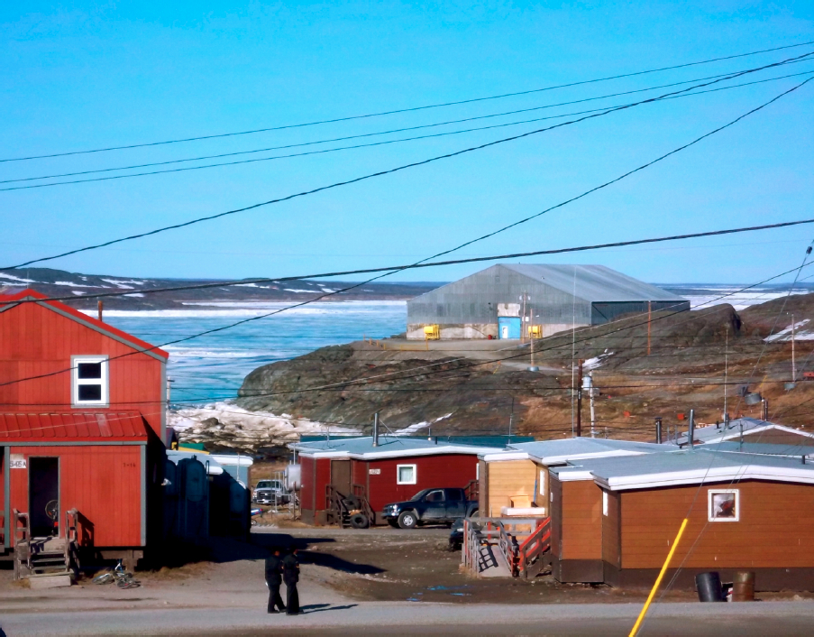
Photo: Tara Cater.
The headframe of the former mine, which burnt down in the late 1970s, was emotively discussed in terms of both its presence and absence in the landscape. It was described as both a landmark for navigation as well as a strong visual symbol of the community’s industrial history. One long-term Qallunaaq resident noted it was “one of the residual things from the [NRNM] that was kind of appreciated.” As harvesters came back from travelling to Marble Island, about 40 km southeast of Rankin Inlet, they would see the headframe “like a telephone pole sticking up from out of the water […] it was a weird-looking thing to see, but a real landmark” (long-term Qallunaaq resident). Many stories were told about the mine headframe as a landmark as well as a symbol of “mineral exploration, development, and opportunities for jobs, and business” (government official). At the same time, for some in the immediate aftermath of mine closure, the industrial ruin provided an unhappy reminder of poverty and struggle. “It was lonely when we came back here to Rankin Inlet,” noted one NRNM miner who returned in the late 1960s after working in Yellowknife. “Seeing the mine closed, it was very lonely because that was the only place where we were making money.” Like other mining remnants, the headframe took on another life post-closure, even as it became an abandoned “no place” divorced from its official meanings. Stories were told of youth playing around or climbing the headframe to look out over the town. The headframe thus came to be a space of recreation and play (Edensor 2005a).
The burning of the headframe in 1970s is associated with a sense of loss. In an interview, one Inuk former miner vividly recalled the event, noting, “When it burned down it looked as though we had nothing left, because you could see that headframe from all the way from the other side of Marble Island, which is 25-30 miles away, and you would see this great big thing and say, that is Rankin Inlet.” Other community members shared similar emotional stories of watching the mineshaft burn: “I had a very nice view of the mineshaft […] we sat up and watched it until two in the morning. Spectacular fire, but not a happy occurrence” (long-term Qallunaaq resident). After the headframe burned, the former mine site remained derelict and, along with the adjacent tailings area, became a sort of industrial junkyard. At some point thereafter, the mineshaft itself was capped, and the site was further cleaned up in the early 1990s concurrently with the removal of scrap metal and the reclamation of the tailings area (Erikson 1995; WESA 2010).
With the headframe gone, the ore crusher and other old machinery remain the most prominent mining artefacts at the site today. Referred to by some in the community as the “elephants,” these massive ruins remain the most significant landmark for visitors and community members to explore (Figure 4). Graffiti, with markings such as “666” and “We all got left behind,” mark the milling equipment, which is surrounded by rusty wires sticking up from the uneven cement slabs that cap the former mineshaft. One Inuk resident referred to their symbolism as “a mirror to who we are right now, strong and standing but broken, vandalised and covered in anger.” In spite of the appearance of neglect, the “elephants” are a prominent visual feature for the community, and interactions with the site are complex.
Many people shared their connection with these ruins, weaving stories of being children and playing on or climbing inside them. One long-term Inuk resident told a story of spiritual creatures that were said to stay around the site and come out if they heard someone crying. Some people simply stated that the “elephants” were part of their everyday geographies, including their daily walks to work, or the view from their windows. One long-term Inuk resident claimed, “I really like the mine site. It makes me feel like I’m home. This is something solid, this was something that was here before anything else. I mean the land was here, but it was one of the first things built in this town. In my eyes it’s like it could have been here forever.” Ultimately, these remains have served as a site of remembrance, rooting the experiences and memories of those who have lived, played, and worked every day around the mined landscape, marking the site as not simply an artefact of the past, but also an ongoing symbol of Rankin Inlet’s identity. One long-term Inuk resident asserted, “I see the [elephants] every day. I tell my stories to kids and grandkids, it’s important [for them] to know.” Since many of today’s residents were not present during this first phase of mining, these stories and associations have become the primary mediums through which industrial remains link past and present lives. Younger generations continue to create new narratives through their own interactions with these industrial remains, and are often seen playing or hanging out at the site.
Figure 4
Remains of the milling equipment from the North Rankin Nickel Mine, Rankin Inlet, 2011

Photo: Arn Keeling.
There was a strong urge expressed by some in the community, especially people working for the Government of Nunavut and Nunavut Tourism, to clean up the site and commemorate the NRNM. For instance, some community members discussed the possibility of rebuilding the headframe as a symbol of Rankin Inlet. A Qallunaaq territorial government official stated, “I have visited the mine site many, many, many times. It’s an attraction for the community, absolutely it is.” Another long-term Inuk resident added, “I was there when the mineshaft was in flames. It was like the history of Rankin burning. I wonder will we ever build a replica? That’s the history.” One long-term Qallunaaq resident suggested that building a replica headframe or placing signage to inform visitors about the industrial ruins would provide “a site, something to see or do” in the town, and make the space a more visible and attractive commemoration of Rankin Inlet’s first experience with mining. By re-constructing the ruins as an attraction, the goal for community members is to become protagonists in shaping their own history and communicating the significance of the NRNM to visitors. As one long-term Inuk resident argued, “Thousands of people travel here even if they are just passing through and their flight is delayed until five. That’s a place people know to go. That place and the inukshuk.[4] People don’t realise how many eyes have seen [the mine site] and where this image has gone to, and who it has affected.” This respondent understood the power of these circulating images of industrial heritage and assumed that, for an outsider, the ruins may look merely like a space of degradation.
In the absence of formal commemorative activities, these landscapes nevertheless function as “personalized industrial heritage” (Summerby-Murray 2007), exhibiting the personal connections Rankin Inlet residents form with physical objects. These industrial ruins provide resources for place identity and community memories. In this sense, they resemble the Inuit “memoryscapes” explored by Nuttall (1992: 57), who highlights the role of memory in “articulating the relationship between community and landscape, or between landscape and an individual”—although in a context very different from that of an industrial settlement. In the embodied experience of industrial ruins, memories of the Rankin Inlet mine are continually re-created and re-circulated through everyday practices, both by those who have personal experience with the NRNM and by those residents who construct their own narratives, 50 years later.
Residual landscapes
Mined landscapes are not just industrial spaces; rather, they represent a “nexus of history, politics, culture, and the focal point of a contested moral landscape” (Bridge 2004: 242). As shown, Rankin Inlet community members mobilise industrial remnants in performing their personal and community identities, making sense out of what remains from the NRNM. Yet the cultural meanings of mined landscapes are complicated by the ongoing presence of industrial hazards, which threaten human and environmental health. For Rankin Inlet residents, this “tangled legacy” (Morin 2009: 1-2) of the abandoned mine represents a conflicted desire both to honour an industrial past and to undertake processes of remediation for a safe present and future. Residents also draw on the experience of this hazard landscape to articulate concerns about the potential adverse environmental impacts of future mining in the region.
The negative environmental impacts of the NRNM have created ongoing challenges for the community. Although the mine ceased operations in 1962, it took until 1995 for final closure and reclamation to be completed (WESA 2010). The NRNM produced 297,000 tonnes of tailings, which were deposited both above and below the high tide mark. Initial clean-up of the NRNM was haphazard, as the company “ran out of money before clean-up was done” (ibid.: 3). A government official stated, “[…] back then, it seemed like there was no consciousness for mines after they left it, they did a pretty mediocre job […].” A long-term Qallunaaq resident agreed, arguing, “[…] the rules back then were really loose, and we ended up with a lot of dangerous tailings in Rankin. And it took a long time for that to get addressed, because we really didn’t have much in the way of government back then.” The tailings began to erode, with the potential to generate acid runoff and leaching of metals into the bay (Kochany et al. 1996). Of great concern to community members was the “red dust” found on sea ice, which was assumed to originate from wind transport of fine tailings. This red dust created scares over the safety of harvesting local food sources.
In 1989, when an industrial subdivision was proposed for the tailings area, contaminated soil was discovered, prompting further environmental studies (Erickson 1995). Eventually, tailings less than one metre thick were extracted and moved to another area, where they were treated to remove the heavy metals, and 100,000 cubic metres of contaminated water was treated on site (AANDC 2012; WESA 2010). Tailings remediation was completed in 1995; however, in 2009, Aboriginal Affairs and Northern Development Canada (AANDC) discovered that a small amount of the tailings area may not have been entirely covered, and in 2011, 15,000 cubic metres of additional clean fill were added (AANDC 2012) (Figure 5). For now, AANDC is monitoring the site to make sure that the freeze-back of tailings in permafrost will be effective and that the area will be safe for community members and the environment.
Figure 5
Ongoing reclamation of the North Rankin Nickel Mine tailings area, Rankin Inlet, 2011

Photo: Arn Keeling.
There seemed to be a consensus among respondents that the tailings have been remediated and, at the moment, are a benign presence in the landscape. But a lingering question remained: what will happen to the tailings as time goes by, and what does this mean for the safety of the site? Although both the federal and territorial governments have held public meetings about the environmental monitoring systems in place, some community members expressed their concerns about the ongoing negative legacy of the NRNM. One long-term Inuk resident stated, “We lost a lot of elders due to health, the toxins left out here. People don’t talk about that. It’s a mystery. People weren’t educated […] it took years to clean up [the] area.” Post-reclamation, Rankin Inlet is still learning about living with the legacies of an abandoned mine. A territorial government official noted, “There’s still a lot of effects that still stem from the [NRNM] […] an example, it’s officially unsafe to eat shellfish, [from areas that were] associated with the old mine.” Nevertheless, part of the former tailings area is now a baseball diamond with artificial turf, serving as a space of recreation, as it cannot be developed for residential or commercial use (Erickson 1995).
As a reclamation project and ongoing environmental hazard, the tailings area is at once haunted by questions of human and environmental health, while providing historical lessons for the community. Several interviewees linked the environmental legacy effects of industrial mining projects in the Canadian North to a need for more information about both the positive and negative aspects of contemporary mining. One long-term Qallunaaq resident, citing the examples of the Nanisivik mine near Arctic Bay and the Giant Mine in Yellowknife, exclaimed, “[there was] orange dust on top of snow [in Rankin Inlet]! […] No one has seemed to reclaim an Arctic mine successfully yet. Will it be [Agnico Eagle]?” This interviewee asserted that since mining projects bring great transformation to the community, they need to be responsible, “ethically and morally, [for their] permanent presence for years to come.” Comments such as these highlighted a critical awareness of the environmental and social legacies of mining boom and bust cycles. As one long-term Inuk resident noted, reflecting on the NRNM experience, “It’s like when Inuit were first forced or moved into communities […] and everyone fell for it, and that’s kind of like opening up the mine here too. I mean there might be some new developments and who knows what will happen […].” In these respects, encounters with post-industrial landscapes also provide frequent reminders of the environmental and economic risks associated with mining.
Images and iconography
The NRNM has remained alive in the community, over 50 years post-closure, finding new life in encounters with landscapes and stories of development, closure, and reclamation. One government official described Rankin Inlet as built over the mine’s hidden former shafts and tunnels—a potent image of the town as both physically and symbolically rooted in this historical mining operation. While many present-day residents were not alive or did not live in the community during the life of the mine, they do draw upon a vast array of images and stories about this first encounter. Just as encounters with the industrial remains of the NRNM reflect practices of social remembering, thus reinforcing community and place identity, mine iconography and images create landscape narratives that can be interpreted so that one may better understand the economic and cultural transformations that mining generates within a community (Wyckoff 1995).
Different from the experience of industrial ruins, where encounters are unruly and reflect personalised industrial heritages and experiences, these landscape narratives tell a hegemonic, largely celebratory story of the industrial past (Harner 2001). Hegemony, in this instance, refers to the power to construct a place identity of Rankin Inlet, through everyday landscapes and images, thus naturalising one particular story of the industrial past. While there are always multiple contested meanings of place, hegemonic landscape images create the perception that all residents share the same understanding of the NRNM and experience that heritage in the same ways. Such landscapes have the power to “codify” industrial heritage, and it is this singular story that circulates through the official images of place identity. Nevertheless, these official stories of development and deindustrialisation are always complicated by personal industrialised heritages, which represent alternative ways of relating to the ongoing legacy of the old mine.
The official (and semi-official) commemorations and images of the NRNM take many forms, including the creation of iconic symbols invoking the industrial past. For instance, the Hamlet of Rankin Inlet and the co-ed softball league have both adopted the NRNM mineshaft as a central symbol in their logos. The hamlet logo highlights the mineshaft alongside an inukshuk, with a mine pickaxe crossed in the centre with a kakivak (a traditional, trident-shaped fishing spear), thereby representing the two forces constructing the identity of the community, the mine and the traditional economy (Hamlet of Rankin Inlet 2013). Similarly, images of the NRNM have also been incorporated into the built landscape, making memory tangible. For example, many of the buildings down the settlement’s main road feature the stylised architecture of the mine headframe. One long-term Inuk resident suggested that this, too, is a mirror of sorts, reflecting that the mine is still very much alive within the community, saying, “the [NRNM is] shut down, but it’s still very much a part of our identity.” The presence of the headframe in the material structure of these buildings reproduces images of industrial heritage and reaffirms place identity (Palmer Peterson 2008). The built landscape thus becomes a grounded narrative, where official stories of how the community developed are encountered, shaping public and personal acts of remembering industrial history.
Significantly, the hegemonic image of Rankin Inlet’s mining past is prominently exhibited in icons and displays in the community’s two adult learning centres. The Nunavut Trades Training Centre, which opened its doors in the fall of 2010 to Nunavut Arctic College trades students, has an NRNM display in its main foyer that features a soapstone carving of a man in traditional Inuit clothing, working together with a miner wearing a hard hat with “NRNM” carved into it, the two men lifting the final rock into place on top of an inukshuk (Figure 6). Much like the Hamlet logo, this sculpture illustrates the two forces of mining and traditional economy that create and maintain the community. Placed next to this sculpture are nickel and copper ore samples from the mine. These chunks of ore are presented without reference to the socio-economic networks that transformed the landscape, the rapid closure of the mine, or the waste left as tailings in the community. Rather, the public display of industrial artefacts reinforces the role of the trades college in training students for the new mining economy. More critically, they represent and value the incorporation of Inuit workers into the mining economy. While the college trains students from all over the territory in a variety of trades, it also has a relationship with the Kivalliq Mine Training Society. Created by Inuit organisations, government, industry, and education partnerships, the Kivalliq Mine Training Society fosters “training to employment plans” for Nunavut Land Claims Beneficiaries who wish to gain employment in the mining sector (long-term Qallunaaq resident). The display in the trades college promotes the idea of a mixed economy where Inuit workers continue culturally significant harvesting activities, while engaging in wage labour. The symbols suggest Inuit today can build on the legacy of old miners working in the NRNM, their capacity to quickly learn skills needed to work above and below ground, and the opportunities that minerals brought to the area. Thus while the sculpture signifies co-existence and collaboration, it also normalises notions of work, industrial time, and wage labour (Stern 2003).
Similarly, the Adult Learning Centre has displays commemorating the NRNM. The foyer of the centre is built around a miniature headframe. On a nearby wall is a large mosaic of old pictures from the NRNM, reflecting the story of development and closure, the participation of Inuit miners, and coexistence with southern workers. The display is open to the public to see and share stories of Rankin Inlet taking physical form within the images. One long-term Qallunaaq resident declared, “The learning centre has a photographic display of mining, and people can go and look at [the board]. And I think people do [go]!” The pictures displayed—black and white archival photographs, as well as colour photographs (most likely still images taken from People of the Rock, a 1962 documentary by the National Film Board of Canada about Rankin Inlet)—prominently feature Inuit workers (some of whose names are labelled) and their positions within the mine. Other images depict the landscape, such as aerial photographs of the area and the burning headframe, showing how the community used to look during the life of the NRNM. As with the NRNM display at the trades centre, the placement of these images and iconography at the Adult Learning Centre not only suggests a persistent sense of connection to Rankin’s mining past but also transmits an underlying normative value of improvement through education and mine labour for today’s residents (cf. Bell 2010).
These icons, images, and built reproductions of the NRNM allow industrial heritage to become “fixed” in time and space, and promote specific ways of experiencing the past. By isolating images, symbols, and industrial artefacts from their wider contexts and displaying them in new spaces, a process of what Edensor (2005a: 134) calls “organized remembering” is created and maintained. By focusing on stories of Inuit workers being incorporated into mining, industrial heritage becomes compartmentalised and ordered for community members, naturalising particular stories of the industrial past. What is not (often) acknowledged in these official industrial heritages is the ongoing remediation of the tailings and concerns about environmental health, or the histories of colonial relations and segregation of Inuit during the life of the mine. The narratives woven into the built landscape of Rankin Inlet constitute what Emilie Cameron (2011) calls a “material ordering practice” shaping particular imaginative geographies of mineral development in the past, present, and future. Nevertheless, it is important to recognise that such hegemonic meanings are not uncontested by either Inuit or Qallunaat, as the critical comments about the negative legacies of mining revealed.
Figure 6
Soapstone sculpture displayed in the foyer of the Nunavut Trades Training Centre, showing the two forces building the community: mining and traditional economy, Rankin Inlet, 2012
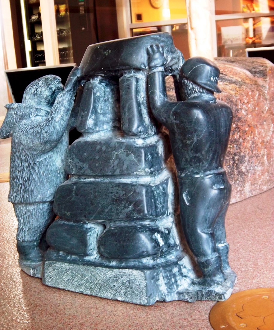
Photo: Tara Cater.
Conclusion
Rankin Inlet residents live within residual landscapes, where mining has transformed their environment, often with destructive consequences for human and environmental health. Decades after the mine’s sudden closure, post-mining spaces in Rankin Inlet still remain lively with processes of embodied and social remembering. In this article, we explored how community members are engaging with their industrial past, and how moving through industrial ruins stimulates forms of remembering. We analysed how residents of Rankin Inlet fold memories and associations with the NRNM into their individual and community heritages, or ways of belonging to place. We then further investigated how processes of social remembering of the NRNM are inscribed in the local landscape, exploring the communication through hegemonic images of a “consensual history” of mineral development (Harner 2001; Mitchell 1992). We suggested how these “official” narratives of mining history embed normative messages around the values of wage labour and industrial development.
The tangled legacy of the NRNM (re)circulates through encounters with industrial ruins, mine iconography, and the associations that many present-day residents have with Inuit miners who worked in the NRNM, whether they are relatives and/or community leaders who continue to tell stories about mineral development. While mine iconography and images project an official community memory of the NRNM, an engagement with industrial ruins shows us personalised industrial heritages in all their ambiguity and disorder. The ambivalence we found in Rankin Inlet towards post-mining landscapes—places imbued with positive memories, even nostalgia, yet also embodying negative social and environmental legacies—echoes findings from other Indigenous communities adjacent to abandoned mines in the North (see Boutet in press; Lim 2013; Sandlos and Keeling 2012). More than a set of symbols of the industrial past impressed into community landscapes, the legacy of the NRNM is open for multiple interpretations and ongoing re-evaluation. By exploring the symbolic attachments of Rankin Inlet residents to the mined landscape, we find that the mine’s remains are folded into present-day landscapes, ways of being, and, as we discovered, debates over future mineral development in the region.
The growth of mineral development in Nunavut, and the Kivalliq Region in particular, is causing stories of the NRNM to re-circulate anew (long-term Qallunaaq resident). Mineral development has become the greatest economic driver within the territory, and strategies by various government bodies have encouraged training and employment opportunities in the industry for Nunavut Land Claims Beneficiaries (Impact Economics 2010; Government of Nunavut 2009). Facing the increase in mineral activity, one long-term Qallunaaq resident suggested, “all has to come together, [we] have to go back and find out where [we] come from.” Contemporary mineral activity is stimulating a desire among a subset of the community to revisit and commemorate past experiences with mining, restaking their claims to Rankin Inlet’s industrial past. This is evident in the desire expressed by some to clean up the mine site and potentially to rebuild a replica of the NRNM mineshaft. In this sense, the mined landscape is a site of both reclamation of the past, and a reference point for the community as it moves forward into negotiations with Agnico Eagle. A long-term Inuk community member stated that it is important for residents to know and not forget their history, in order not to be reactive in the face of the Meliadine project. Rankin Inlet residents repeatedly asserted that more foresight was needed about the risks and opportunities of contemporary projects, lessons which could be drawn from previous experiences and their long-term legacies. One long-term Inuk resident reflected on the ongoing process of remediating the NRNM tailings and related health concerns, saying, “[We need] just more awareness and preparation […] knowledge of the expected outcomes […] of mining.” With the prospect of a major new mine adjacent to the community, Rankin Inlet is drawing on experiences of the social and environmental legacies of the NRNM to come to terms with the risks and opportunities as mining comes back to town.
Parties annexes
Acknowledgments
Research for this article was funded by ArcticNet, the Social Sciences and Humanities Research Council (SSHRC), and the Northern Scientific Training Program. The authors gratefully acknowledge the co-operation of the Hamlet of Rankin Inlet and the research assistance of Pallulaaq Friesen, Piita Irniq, and Patricia Boulter. Access to the photos of the Kenneth Whatmough Fonds was generously provided by Edward Atkinson, Nunavut territorial archivist.
Notes
-
[1]
Nanisivik, near Arctic Bay (Ikpiarjuk) on northern Baffin Island, was founded around the Nanisivik mine in 1976, but the community was completely abandoned after closure in 2002.
-
[2]
In Inuktitut, Qallunaaq (plural, Qallunaat) is the word used for white people or Europeans.
-
[3]
The photographs and film are part of the Kenneth Whatmough Fonds, at the Nunavut Archives. Whatmough was the mine’s first engineer and general manager (1953-1957). The film, entitled Rankin Inlet Mines Limited Part I: History of Development, documents the shipping of materials and construction of the mine, probably around 1956.
-
[4]
That inukshuk (‘cairn’ in Inuktitut) was built in 1991 by Joe Nattar and stands on a hill, overlooking Williamson Lake in the centre of the community.
References
- AANDC (ABORIGINAL AFFAIRS AND NORTHERN DEVELOPMENT CANADA), 2012 The Big Picture: Contaminated Sites in Nunavut, Ottawa, Aboriginal Affairs and Northern Development Canada.
- BELL, Jim, 2011 A New Mine? This Nunavut Town Says it’s Ready, Nunatsiaq News, 12 April.
- BELL, Lindsay, 2010 Economic Insecurity as Opportunity: Job Training and the Canadian Diamond Industry, in M. Daveluy, F. Lévesque and J. Ferguson (eds), Humanizing Security in the Arctic, Edmonton, Canadian Circumpolar Institute Press: 293-304.
- BERNAUER, Warren, 2011 Mining and the Social Economy in Baker Lake, Nunavut, Saskatoon, University of Saskatchewan, Centre for the study of Co-operatives.
- BLASER, Mario, Harvey A. FEIT and Glenn McRAE, 2004 In The Way of Development: Indigenous Peoples, Life Projects, and Globalization, London, Zed Books, and Ottawa, International Development Research Centre.
- BOULTER, Patricia Jean, 2011 The Survival of an Arctic Boom Town: Socio-Economic and Cultural Diversity in Rankin Inlet, 1956-63, M.A. thesis, Memorial University, St. John’s.
- BOUTET, Jean-Sébastien, in press Opening Ungava to Industry: A Decentering Approach to Indigenous History in Subarctic Québec, 1937-54, Cultural Geographies, 21(1): 79-97.
- BRIDGE, Gavin, 2004 Contested Terrain: Mining and the Environment, Annual Review of Environment and Resources 29: 205-259.
- CAMERON, Emilie, 2011 Copper Stories: Imaginative Geographies and Material Orderings of the Canadian Arctic, in Andrew Baldwin, Laura Cameron and Audrey Kobayashi (eds), Rethinking the Great White North: Race, Nature and the Historical Geographies of Whiteness in Canada, Vancouver, University of British Columbia Press: 169-192.
- CRESSWELL, Tim, 2003 Landscape and the Obliteration of Practice, in Kay Anderson, Mona Domosh, Steve Pile and Nigel Thrift (eds), The Handbook of Cultural Geography, London, Sage: 269-281.
- COLLIGNON, Béatrice, 2006 Knowing Places: The Innuinait, Landscape, and the Environment, Edmonton, CCI Press.
- DAILEY, Robert C. and Lois A. DAILEY, 1961 The Eskimo of Rankin Inlet: A Preliminary Report, Ottawa, Department of Northern Affairs and Natural Resources.
- DAHL, Jens, 2000 Saqqaq: An Inuit Hunting Community in the Modern World, Toronto, University of Toronto Press.
- DORAIS, Louis-Jacques, 1997 Quaqtaq: Modernity and Identity in an Inuit Community, Toronto, University of Toronto Press.
- EDENSOR, Tim, 2005a Industrial Ruins: Spaces, Aesthetics, and Materiality, Oxford, Berg.
- EDENSOR, Tim, 2005b The Ghosts of Industrial Ruins: Ordering and Disordering Memory in Excessive Space, Environment and Planning D: Society and Space, 23(6): 829-849.
- ERICKSON, Paul, 1995 Reclamation of the North Rankin Nickel Mine Tailings: Final Report, Yellowknife, Government of the Northwest Territories.
- ESCOBAR, Arturo, 2001 Culture Sits in Places: Reflections on Globalism and Subaltern Strategies of Localization, Political Geography, 20(2): 139-174.
- FRANCAVIGLIA, Richard V., 1991 Hard Places Reading the Landscape of America’s Historic Mining Districts, Iowa City, University of Iowa Press.
- GIBSON, Ginger and Jason KLINCK, 2008 Canada’s Resilient North: The Impact of Mining on Aboriginal Communities, Pimatisiwin: A Journal of Aboriginal and Indigenous Community Health, 3(1): 116-139.
- GOIN, Peter and Elizabeth RAYMOND, 2004 Changing Mines in America, Chicago, University of Chicago Press.
- GOVERNMENT OF NUNAVUT, 2009 Parnautit: A Foundation for the Future. Mineral Exploration and Mining Strategy, Iqaluit, Department of Economic Development and Transportation.
- GRABURN, Nelson, 2006 Culture as Narrative, in Pamela Stern and Lisa Stevenson (eds), Critical Inuit Studies: An Anthology of Contemporary Arctic Ethnography, Lincoln, University of Nebraska Press: 139-154.
- HALVAKSZ, Jamon Alex, 2008 Whose Closure? Appearances, Temporality, and Mineral Extraction in Papua New Guinea, Journal of the Royal Anthropological Institute, 14(1): 21-37.
- HAMLET OF RANKIN INLET, 2013 The Hamlet Symbol (online at: http://www.rankininlet.ca/rankin_symbol.html).
- HARNER, John, 2001 Place Identity and Copper Mining in Sonora, Mexico, Annals of the Association of American Geographers, 91(4): 660-680.
- IMPACT ECONOMICS, 2010 Nunavut Economic Outlook: Nunavut’s Second Chance, Iqaluit, Nunavut Economic Forum.
- JANSEN, William H., 1979 Eskimo Economics: An Aspect of Culture Change at Rankin Inlet, Ottawa, National Museum of Canada.
- KOCHANY, J., A. LUGOWSKI, V. MENKAL and P.L.M. ERICKSON, 1996 Tailing Pond Remediation in the Canadian Arctic, Environmental Technology, 17(10): 1113-1121.
- LIM, Tee Wern, 2013 Inuit Encounters with Colonial Capital: Nanisivik - Canada’s First High Arctic Mine, M.A. thesis, University of British Columbia, Vancouver.
- MARSH, Ben, 1987 Continuity and Decline in the Anthracite Towns of Pennsylvania, Annals of the Association of American Geographers, 77(3): 337-352.
- MITCHELL, Don, 1992 Heritage, Landscape, and the Production of Community: Consensus History and its Alternatives in Johnstown, Pennsylvania, Pennsylvania History, 59(3): 198-226.
- MITCHELL, Don, 2004 Landscape, in David Sibley, David Atkinson, Peter Jackson and Neil Washbourne (eds), Cultural Geography: A Critical Dictionary of Key Ideas, London, Taurus: 48-56.
- MORIN, Bode J., 2009 Reflection, Refraction, and Rejection: Copper Smelting Heritage and the Execution of Environmental Policy, Ph.D. dissertation, Michigan Technological University, Houghton.
- NATURAL RESOURCES CANADA, 2013 Exploration Plus Deposit Appraisal Expenditures, by Province and Territory, 2008-2013, Mines and Minerals Sector (online at: http://sead.nrcan.gc.ca/expl-expl/18-eng.aspx).
- NUTTALL, Mark, 1992 Arctic Homeland: Kinship, Community and Development in Northwest Greenland, Toronto, University of Toronto Press.
- NUTTALL, Mark, 2001 Locality, identity and memory in south Greenland, Ḗtudes/Inuit/Studies, 25(1-2): 53-72.
- PALMER PETERSON, Helen, 2008 Landscapes of Capital: Culture in an Industrial Western Company Town, Clarkdale, Arizona, 1914-1929, Ph.D. dissertation, Northern Arizona University, Flagstaff.
- PRATT, Mary-Louise, 1992 Imperial Eyes: Travel Writing and Transculturation, London, Routledge.
- ROBERTSON, David, 2006 Hard as the Rock Itself: Place And Identity in the American Mining Town, Boulder, University Press of Colorado.
- SANDLOS, John and Arn KEELING, 2012 Claiming the New North: Development and Colonialism at the Pine Point Mine, Northwest Territories, Canada, Environment and History, 18(1): 5-34.
- SCHEIN, Richard H., 1997 The Place of Landscape: A Conceptual Framework for Interpreting an American Scene, Annals of the Association of American Geographers, 87(4): 660-680.
- SEARLES, Edmund, 2008 Inuit Identity in the Canadian Arctic, Ethnology, 47(4): 239-255.
- SEARLES, Edmund, 2010 Placing Identity: Town, Land, and Authenticity in Nunavut, Canada, Acta Borealia, 27(2): 151-166.
- STEPHENSON, Carol and David WRAY, 2005 Emotional Regeneration Through Community Action in Post-Industrial Mining Communities: The New Herrington Miners’ Banner Partnership, Capital and Class, 29(3): 175-199.
- STERN, Pamela, 2003 Upside-Down and Backwards: Time Discipline in a Canadian Inuit town, Anthropologica, 45(1): 147-161.
- SUMMERBY-MURRAY, Robert, 2007 Interpreting Personalized Industrial Heritage in the Mining Towns of Cumberland County, Nova Scotia: Landscape Examples from Springhill and River Hebert, Urban History Review, 35(2): 51-59.
- TESTER, Frank and Peter KULCHYSKI, 1994 Tammarniit (Mistakes): Inuit Relocation in the Eastern Arctic, 1939-63, Vancouver, University of British Columbia Press.
- WESA, 2010 The North Rankin Nickel Mine Site Records Review Report, Kingston, WESA.
- WILLIAMSON, Robert G., 1974 Eskimo Underground: Socio-Cultural Change in the Canadian Central Arctic, Uppsala, University of Uppsala, Institute for General and Comparative Ethnography.
- WILLIAMSON, Robert G. and Terence W. FOSTER, 1975 Eskimo Relocation in Canada, Ottawa, Department of Indian and Northern Affairs.
- WINCHESTER, Hilary P.M., Lily KONG and Kevin C. DUNN, 2003 Landscapes: Ways of Imagining the World, Harlow, Pearson and Prentice Hall.
- WYCKOFF, William, 1995 Postindustrial Butte, Geographical Review, 85(4): 478-496.
 10.7202/1015921ar
Liste des figures
Figure 1
Locations of Baker Lake, Rankin Inlet, and associated mine sites
Map by Quinn Dekking.
Figure 2
North Rankin Nickel Mine under construction, ca. 1957
Photo: Kenneth Whatmough.
Figure 3
The “con shed” remains a key feature of Rankin Inlet, 2012
Photo: Tara Cater.
Figure 4
Remains of the milling equipment from the North Rankin Nickel Mine, Rankin Inlet, 2011
Photo: Arn Keeling.
Figure 5
Ongoing reclamation of the North Rankin Nickel Mine tailings area, Rankin Inlet, 2011
Photo: Arn Keeling.
Figure 6
Soapstone sculpture displayed in the foyer of the Nunavut Trades Training Centre, showing the two forces building the community: mining and traditional economy, Rankin Inlet, 2012
Photo: Tara Cater.