Résumés
Abstract
Eleven paleogeographic maps and a summary ice retreat map outline the history of advance, retreat, and readvances of the Laurentide Ice Sheet along with associated changes in proglacial drainage and relative sea level oscillations for Late Wisconsinan and Holocene times. The text outlines pertinent chronological control and discusses the paleoglaciology of the ice sheet, with attention to location and migration of ice divides, their attendant domes and saddles, and to ice streams, ice shelves, and mechanisms of déglaciation. At 18 ka the ice sheet consisted of 3 sectors with an interlocked system of ice divides joined at intersector saddles. A throughgoing superdivide is recognized and named the Trans Laurentide Ice Divide. The ice sheet retreated slowly from 18 to 13 ka, mainly along the west and south margins, but still held a near maximum configuration at 13 ka. A regional change in flow pattern over the Prairies just before 14 ka is thought to represent a large reduction in ice volume, but not in extent, and likely was triggered by a switch from nondeforming to deforming bed conditions. Retreat between 13 and 8 ka was vastly more rapid in the west than in the east, which resulted in eastward migration of the divide system of Keewatin Ice but relatively static divides of Labrador and Foxe Ice. By 10 ka the Trans Laurentide Ice Divide had been fragmented as Hudson Ice became increasingly autonomous. By 8 ka Hudson Ice had disappeared, little ice was left in Keewatin, but Foxe Ice still held its near maximum configuration and Labrador Ice was still larger than Foxe Ice. Repeated surging along aquatic margins and calving back of margins thinned by surging probably was the most important mechanism of deglaciation of Keewatin and Hudson Ice. The core of Foxe Ice disintegrated at 7 ka but retreat and readvance of Foxe Ice remnants continued throughout the Holocene.
Résumé
Onze cartes paléogéographiques et une carte sommaire du retrait glaciaire retracent l'évolution de la calotte glaciaire ainsi que les changements relatifs au drainage proglaciaire et aux fluctuations du niveau de la mer pendant le Wisconsinien supérieur et l'Holocène. Le texte fait ressortir les données chronologiques appropriés et étudie la paléoglaciologie de l'inlandsis, en mettant l'accent sur la localisation et le déplacement de la ligne de partage des glaces, des dômes et des cols satellites, ainsi que des langues glaciaires, des plates-formes de glace flottante et des mécanismes de la déglaciation. À 18 ka, l'inlandsis est composé de trois secteurs avec un système emboîté de lignes de partage des glaces. Une grande ligne de partage, « la ligne de partage des glaces translaurentidiennes », traverse le système. L'inlandsis se retire lentement de 18 à 13 ka, surtout le long les marges ouest et sud, mais à 13 ka sa configuration reste à peu près inchangée. On croit qu'une modification du régime de l'écoulement glaciaire survenue dans la Prairie un peu avant 14 ka est à l'origine d'une réduction sensible du volume de glace, mais pas de l'étendue. Entre 13 et 8 ka, le retrait glaciaire, beaucoup plus rapide à l'ouest qu'à l'est, se manifeste par le déplacement vers l'est du système de partage des glaces au Keewatin et par la relative stabilité de la ligne de partage entre les glaciers du Labrador et de Foxe. À 10 ka, la ligne de partage translaurentidienne est morcelée et le glacier d'Hudson gagne son autonomie. Vers 8 ka, le glacier d'Hudson est disparu, il ne reste à peu près plus de glace au Keewatin, mais le glacier de Foxe conserve sa configuration et le glacier du Labrador est encore plus étendu que le glacier de Foxe. Les crues glaciaires répétées le long des marges marines et le vêlage des marges ont probablement constitué les processus de déglaciation les plus importants au Keewatin et en Hudsonie. Le coeur du glacier de Foxe est dissous à 7 ka, mais retraits et récurrences des vestiges du glacier de Foxe se poursuivent tout au long de l'Holocène.
Zusammenfassung
EIf paleogeographische Karten und eine zusammenfassende Karte des Eisrückzugs skizzieren die Geschichte des Vorsto00DFes, Rückzugs und Rückvorsto00DFes der laurentischen Eisdecke zusammen mit den damit verbundenen Veränderungen in der proglazialen Entwässerung und den Schwankungen des relativen Meeresspiegels für die Zeit des späteren glazialen Wisconsin und des Holozän. Der Text gibt einen Überblick über einschlägige chronologische Kontrolle und behandelt die paleoglaziale Geschichte der Eisdecke, insbesondere in Bezug auf Vorkommen und Verschiebung der Eistrennlinien, der sie begleitenden Dome und Sättel und der Eisströme, Eisbänke und der Enteisungs-Mechanismen. Um 18 ka bestand die Eisdecke aus drei Sektoren mit einem ineinandergreifenden System von Eistrennlinien, die an den Kreuzungssätteln verbunden sind. Eine durchgehende gro00DFe Trennlinie ist deutlich sichtbar und wird die translaurentische Eistrennlinie genannt. Die Eisdecke zog sich zwischen 18 und 13 ka langsam zurück, vorwiegend entlang der West- und Südränder, hatte aber immer noch die fast maximale Ausdehnung um 13 ka. Zwischen 13 und 8 ka war der Rückzug im Westen deutlich schneller als im Osten, was zu einer Ostwärts-Bewegung der Trennlinien des Keewatin-Eises führte, jedoch zu reltiv statischen Trennlinien des Labrador- und Fox-Eises. Um 10 ka hatte sich die translaurentische Eistrennlinie zerstückelt während das Hudson-Eis zunehmend selbständig wurde. Um 8 ka war das Hudson-Eis verschwunden, nur wenig Eis war im Keewatin übriggeblieben während das Fox-Eis immer noch seine fast maximale Ausdehnung hatte und das Labrador-Eis immer noch ausgedehnter war als das Fox-Eis. Wiederholtes Anschwellen entlang der Küsten und Rück-kalben der ausgedünnten Eisränder war wohl der wichtigste Enteisungsvorgang des Keewatin- und Hudson-Eises. Der Kern des Fox-Eises zersetzte sich um 7 ka, aber Rückzug und Vorsto00DF der Fox-Eisreste setzte sich durch das Holozän fort.
Corps de l’article
Introduction
Since publication of the summary reports and maps on the glacial geology of Canada (PREST, 1957, 1969, 1970; PREST et al., 1968), which dealt in part with the Late Wisconsinan and Holocene history of the Laurentide Ice Sheet, three major problems have dominated research and discussion: (i) location of the Late Wisconsinan glacial limit, (ii) surface geometry of the ice sheet, and (iii) synchrony or asynchrony of marginal fluctuations in the north versus the south. This Introduction briefly summarizes recent development of ideas on these topics, and the body of the paper presents a series of paleogeographic reconstructions spanning the interval 18-5 ka (Map 1703A) and a revised ice retreat map (Map 1702A)[1].
The Glacial Limit
Initially the limit of PREST (1969) was questioned only in the northeast, between northern Labrador and northern Baffin Island. Prest had placed the limit, for the most part, well out on the Continental Shelf, showing Late Wisconsinan ice free areas on only four low forelands of eastern Baffin Island, where LØKEN (1966) had identified surface marine deposits that predate the Late Wisconsinan. Later work on Baffin Island demonstrated that such "old" surface marine deposits were widespread beyond the Cockburn Moraines (Baffinland Drift) and that drift and rock beyond these moraines was subdivisible into two or more "weathering zones" representing different durations of subaerial weathering following glaciation. Hence, a series of papers (see ANDREWS and IVES, 1972; MILLER and DYKE, 1974; IVES, 1978) argued that the Late Wisconsinan Laurentide limit lay well back on land on Baffin Island, probably at the Cockburn Moraines, and at moraines marking the limit of the youngest weathering zone in northern Labrador. These ideas of "restricted" Late Wisconsinan ice in Arctic Canada were at first received with caution and skepticism or as a self-evident contradiction; "arctic" implied "cold" and complete glaciation. As the ideas became more acceptable with growth of the chronological data base and publication of results, workers around much of the periphery of the ice sheet, as well as those studying peripheral ice masses, proposed Late Wisconsinan limits well behind those of PREST (1969). In the Atlantic Provinces, research methods were directly comparable to those that had been applied farther north (GRANT, 1977; BROOKES, 1977) although "old" marine deposits were not found to substantiate conclusions based on weathering zonation. In the southwest, drift previously thought to have been of Late Wisconsinan age was subdivided on the basis of extent of morphological degradation, the fresher drift delimiting the last ice cover (STALKER, 1977). Radiocarbon dates from lake cores in the older drift apparently support that interpretation (JACKSON, 1979; SCHWEGER, in press). In the northwest VINCENT (1982; in press a) suggested that the Late Wisconsinan limit of PREST (1969) dated from early in the last glaciation (Early Wisconsinan or Sangamonian time) and that the Late Wisconsinan limit lay well to the east, mostly on Victoria Island. Vincent's interpretation was based on subdivision of the regional till cover into lithologically different surface till sheets and correlation of these surface tills with tills exposed in stratigraphie sections in known relation to interglacial beds.
By the early 1980s then, various researchers had argued for retraction of the inferred Late Wisconsinan glacial limit, placing it well behind the Early Wisconsinan (or Sangamonian?) limit almost everywhere except in the American West, Midwest, and New England. These interpretations, however, have met with anything but universal acceptance. Useful and detailed critical appraisals and counter arguments can be found in DENTON and HUGHES (1981). Most workers on the American Plains (MICKELSON et al., 1983; CLAYTON and MORAN, 1982; FULLERTON and COLTON, 1986) do not accept Stalker's glacial limit in Alberta but place the Late Wisconsinan Laurentide margin far south in Montana. New England workers (see MICKELSON et al., 1983) favour much more extensive Laurentide ice in the Appalachians and Gulf of Maine than does GRANT (1977) or RAMPTON et al. (1984). Because of these disagreements, PREST (1984) was unable to portray a single Late Wisconsinan limit that met with any concensus; instead he showed two (a minimum and maximum portrayal), the outer similar to his 1969 reconstruction.
Recent work on the northwestern Laurentide Ice Sheet has also countered the trend of drawing "restricted" Late Wisconsinan glacial limits. HUGHES et al. (1981) conclude that the Laurentide Ice Sheet reached its all-time limit in the northeastern Yukon during the Late Wisconsinan, reversing the earlier conclusion (HUGHES, 1972) that the limit was of Early Wisconsinan age. DYKE (in press) argues that the Early Wisconsinan (or Sangamonian) limit of VINCENT (1983) on Banks Island is to Late Wisconsinan age, reverting to the age assignment of PREST (1969). SHARPE (1984) questions the Late Wisconsinan limit of Vincent on southwestern Victoria Island and concludes that ice was more extensive. The reconnaissance nature of most arctic studies ensures that these major questions will remain open.
Ice Sheet Geometry
Discussions of the surface geometry of the ice sheet resumed during the late 1970s, following a long period when the concepts of FLINT (1943, 1947, 1971) held sway. Flint has proposed that the ice sheet had the relatively simple form of a dome centred over Hudson Bay. IVES and ANDREWS (1963) had proposed a separate centre of dispersal for the northeastern part of the ice sheet, over Foxe Basin, as a spur projecting northward from the main centre over Hudson Bay. Reconstructions of isostatically delevelled shorelines appeared to support this view of the ice sheet as a whole (ANDREWS, 1970, 1973). PREST (1970), however, continued to describe the ice sheet as a system of three interacting "sectors". Recently there has been a return to the more complex interpretation of the ice sheet configuration, although there is continuing debate about the position of ice divides, domes, major saddles, ice streams, ice shelves and the ice sheet margin itself (SHILTS et al., 1979; SHILTS, 1980; ANDREWS and MILLER, 1979; DYKE et al., 1982; DYKE, 1984; PREST, 1984; FISHER et al., 1985).
Synchrony of Marginal Fluctuations
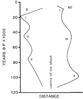
Thinking on this problem has gone through four phases since 1970 and is intimately linked with the problem of defining the Late Wisconsinan limit. During the first phase (Fig. 1A), represented by PREST (1969), Wisconsinan ice was thought to have reached its maximum extent during Late Wisconsinan time around most of the ice sheet perimeter. Some asynchrony of retreat was recognized, for the northwest and northeast margins apparently remained at their limits until 14 and 15 ka, respectively, while the south margin had started to retreat about 18 ka in most places (excepting the Des Moines Lobe, which did not attain its maximum until 14.5 ka). The obvious explanation for this pattern was that colder conditions along Arctic margins delayed onset of retreat there.
The second phase arose from work on Baffin Island during the early 1970s when a tripartite sequence of "Wisconsin" (= last glaciation) advances was recognized, each advance less extensive than the preceding one (Fig. 1B). That pattern contrasted with the presumed record of Early, Middle, and Late Wisconsinan advances along the south margin, each of which seemed more extensive than the preceding one. Furthermore, recognition of the Cockburn Moraines (8-9 ka) as the Late Wisconsinan limit enhanced the apparent asynchrony of onset of retreat between the north and south margins. Again a simple and satisfying climatic theory was called upon to explain this north-south asynchrony. Early advances were extensive on Baffin Island, where glacial inception had occurred early. Development of the main southern mass of the ice sheet blocked storm tracks and reduced accumulation on the northern parts of the ice sheet, which led to sequential reduction in mass and extent of ice. Attainment of the last stadial maximum during the early Holocene resulted from re-establishment of more meridional circulation patterns accompanying substantial recession of the south margins.
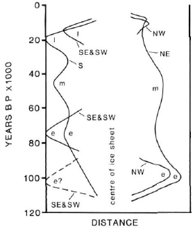
The third phase (Fig. 1C) substantially complicated these ideas and rendered the climatic theory unsatisfactory, because fluctuations of the southeast and southwest margins were brought into phase with those of the northeast margin. In the Atlantic Provinces, GRANT (1977) concluded that the strong southeastward flow of ice across Nova Scotia and out onto the shelf had occurred during the Early Wisconsinan and that by Late Wisconsinan time that monolithic ice mass had been reduced to a multicentred, local (maritime) ice complex. Recent work on the Scotian Shelf and Gulf of Maine supports the concept of progressive diminution of ice mass from Early to Middle to Late Wisconsinan (KING and FADER, 1986; PIPER et al., 1986). Furthermore, the Newfoundland Ice Cap seems to have left a similar record (GRANT, 1977; BROOKES, 1977). In southwest Alberta, STALKER (1977) proposed that the Late Wisconsinan advance had been much less extensive than the Early Wisconsinan one (see also JACKSON, 1979; SCHWEGER, in press); VINCENT (1983) and RAMPTON (1982) reached similar conclusions for the northwestern part of the ice sheet. Hence, the model of Fig. 1B (left hand side) was thought to apply only to the central southern margin (New England to Great Lakes area). The start of substantial retreat was considered to have been delayed until about 14 ka in both the southeast (GRANT, 1977) and southwest (CLAYTON and MORAN, 1982) and until about 10 ka in the northwest (HODGSON and VINCENT, 1984), interpretations that reduced the apparent asynchrony in start of retreat of the various margins. An explanation of similarity of behaviour of widely separated segments of the ice sheet, on the scale of stades and interstades, would have to differ substantially from that applied during the second phase and would likely have to involve changes in hemispheric scale circulation patterns or global sea level fluctuations.
Figure 1
A

B
C
D

Changing time-distance interpretations of the Laurentide Ice Sheet 1970-1986. S, N, etc. refer to the south and north margins, etc. ; e, m, and I refer to Early, Middle and Late Wisconsinan advances.
Modifications (en 4 phases) apportées à l'interprétation des limites spatio-temporelles de la calotte glaciaire laurentidienne (1970-1986). S, N, etc. se rapportent aux marges sud, nord, etc.; e, m et I se rapportent aux récurrences survenues au Wisconsinien inférieur, moyen et supérieur.
During the fourth phase (Fig. 1D), HUGHES et al. (1981) and DYKE (in press) concluded that the northwest margin of the ice sheet reached its maximum extent during Late Wisconsinan time and that retreat began by 16 ka (HUGHES et al., 1981) and possibly by 25 ka (below). VINCENT (in press a), however, holds to a more reduced ice margin. MICKELSON et al. (1983) and FULLERTON and COLTON (1986) argue convincingly that the maximum extent of ice in Montana during the Wisconsinan occurred in Late Wisconsinan time. Hence it seems possible that the northwest, southwest and south margins behaved synchronously but out of step with the southeast and northeast margins.
Paleogeographic Reconstructions
That introductory historical summary should serve to warn the reader that ideas are rapidly changing and that any reconstruction of the Laurentide Ice Sheet must choose among diverse conclusions. In our reconstructions (Maps 1702A, 1703A) we have tried to follow the primary conclusions of (i) the various regional chapters of "Quaternary Geology of Canada and Greenland" (FULTON et al., 1987), (ii) the synthesis of CLAYTON and MORAN (1982) for the western and central USA; (iii) the GSA Special Paper on deglaciation of New England and adjacent Québec (BORNS et al., 1985); (iv) the Surficial Geological Map of Maine (THOMPSON and BORNS, 1985); (v) RAMPTON et al.'s (1984) Quaternary geology of New Brunswick, and (vi) the recent symposium volumes on Lake Agassiz and the Quaternary Great Lakes (TELLER and CLAYTON, 1983; KARROW and CALKIN, 1985). Information on radiocarbon dates, if not specifically referred to, is contained in these major regional reports. Much of the sea level data comes from relative sea level curves in the same reports, from marine limit altitudes on the Glacial Map of Canada (PREST et al., 1968), or from data published in radiocarbon date lists. Much of the sea level data is also summarized on the Paleo-sealevel Map of Canada (PELLETIER, in prep.). In addition colleagues at the Geological Survey of Canada have provided advice and unpublished material particularly D. R. Grant, D. A. Hodgson, and J. J. Veillette.
Late Wisconsinan Buildup
On the southern Interior Plains ice advanced to its Late Wisconsinan limit from a severely retracted Middle Wisconsinan position (DREDGE and THORLEIFSON, 1987). This advance occurred after 27 ka at Watino, Alberta, after 24 ka at Medicine Hat, Alberta and at Zelena, Manitoba, and after 21 ka in the area covered by the Des Moines Lobe (FULTON et al., 1984; CLAYTON and MORAN, 1982). The extent of the Late Wisconsinan advance farther north on the Interior Plains is not known, but in Bonnet Plume basin of the Yukon Territory the ice reached its limit sometime after 37 ka and meltwater was diverted into the basin of proglacial Lake Old Crow by ice near or at its limit sometime after 21 ka. (HUGHES et al., 1981; in press).
The youngest date from below Late Wisconsinan till in southern Ontario is about 23 ka; ice was advancing farther south across Ohio by 22 ka. In Pennsylvania the ice is thought to have reached its limit by 18.5 ka (COTTER et al., 1985). Organic deposits overlain by till in the lower St. Lawrence Valley have been dated as young as 24 ka (BRODEUR and ALLARD, 1985) but subsequent redating of these deposits has shown that they are beyond the range of radiocarbon dating (M. Allard, Dépt. de géographie, Université Laval, personal communication, 1986).
Advance to the northern Late Wisconsinan Laurentide limit has not been dated closely. Organic materials recovered beneath the youngest till are beyond the range of radiocarbon dating and generally indicate conditions at least as warm as present (see DYKE and MATTHEWS, in press).
18 ka Paleogeography (Map 1703A, Sheet 1)
The margin
By 18 ka the Laurentide Ice Sheet stood at or near its Late Wisconsinan limit almost everywhere. The Cordilleran Ice Sheet, in contrast, was still in the stage of reoccupying the intermontane plateau from alpine glacier complexes that had retreated to the Coast Range and Rocky Mountains during the Olympia Nonglacial Interval (RYDER and CLAGUE, in press). We show fully coalescent Laurentide and Cordilleran ice at 18 ka. From west-central Alberta to the 60th parallel the flow pattern in the zone of coalescence indicates abuttment of the two ice masses. The absence of a drumlin or fluting pattern demonstrating coalescent flow indicates either that the coalescence was brief or that the two ice sheets attained their maxima at different times and did not necessarily coalesce. An ice-free corridor between the southwestern Laurentide and Cordilleran ice sheets possibly is indicated by lake sediment cores from the corridor yielding basal dates of 18.4 ka (MOTT and JACKSON, 1982) and 23.6 ka (SCHWEGER, in press). But dates on this type of material from this region may be unreliable (CLAYTON and MORAN, 1982). Consequently we place the 18 ka margin at the Late Wisconsinan limit as proposed by FULLERTON and COLTON (1986) in Montana.
We use CLAYTON and MORAN's (1982) phase D position, dated by them at roughly 20 ka, from Montana to the Lake Michigan Lobe. This position implies a Late Wisconsinan age for Hewitt phase glaciation of Minnesota, assigned to the Middle Wisconsinan or earlier (60-30 ka) by WRIGHT (1972) and WRIGHT et al. (1973). The dates on which this older age is based seen problematic (CLAYTON and MORAN, 1982) and the inferred presence of stagnant ice throughout the interval between the Hewitt phase and the definitely Late Wisconsinan St. Croix phase argues for a Late Wisconsinan age for the Hewitt phase as well. This younger age assignment is also supported by the only slight weathering of Hewitt phase drift and the fresh morphology of the Wadena Drumlin Field (WRIGHT and RUHE, 1965). From the Lake Michigan Lobe to Cape Cod we retain the Late Wisconsinan limit of PREST (1969). KING and FADER (1986) propose that during Late Wisconsinan time the Gulf of Maine, at least the Canadian part of it, was covered by an ice shelf that grounded on Truxton Swell to produce a moraine at about 17 ka. We use that margin as the 18 ka position and suggest that the ice shelf extended into the American sector of the Gulf, floating over deep shelf basins but grounding around their edges. By placing the grounding line just off the present coast we can accommodate a Late Wisconsinan nunatak in the Caledonia Highlands of southern New Brunswick (RAMPTON et al., 1984).
The margin off Nova Scotia is located between the present coastline and the Scotian Shelf Moraines, which were previously thought to mark the Late Wisconsinan limit of grounded ice but now are considered to be Middle Wisconsinan (KING and FADER, 1986). PIPER et al., (1986) mapped a limit of Late Wisconsinan till only 5 km beyond the southern shore of Nova Scotia, till that appears contemporaneous with an unconformity thought to represent the Late Wisconsinan sea level lowering to -120 m (see below). The margin of the Nova Scotia Ice Cap is similar to that portrayed by GRANT (1977) and PREST (1984). This ice covered all of the province except the Cape Breton Highlands. We place the ice margin well out on the Magdelan Shelf to accommodate a proposed Late Wisconsinan centre of outflow on and adjacent to northern Prince Edward Island (PREST, 1971, 1972, 1973; RAMPTON et al., 1984). At 18 ka the Laurentide Ice Sheet had not yet advanced onto Anticosti Island according to GRATTON et al. (1986) but it is believed to have coalesced with the northern tip of the Newfoundland Ice Cap (GRANT, 1977).
IVES (1978), FULTON and HODGSON (1979) and PREST (1984) had speculated that the Laurentide limit lay well back on land on southern Labrador but a key radiocarbon date of ca. 20 ka from a lake core beyond their limit has since proven to be spurious (KING, 1985). Hence we place the ice limit off the south and central Labrador coast but behind the rim of the Torngat Mountains in the north where weathering zones and soil development on moraines argue for existence of Late Wisconsinan nunataks above and beyond the Saglek Moraines (CLARK and JOSENHANS, 1986). JOSENHANS et al. (1986) conclude that Late Wisconsinan Labrador Ice advanced well out on the Continental Shelf and deposited a till. The till is only slightly consolidated and is thought to have been deposited during retreat as the ice became buoyant sometime after about 20 ka. Consequently we show an extensive ice shelf off the Labrador coast at 18 ka. The Nachvak Glaciation of Nachvak Fiord is tentatively dated to the interval 17-23 ka by EVANS and ROGERSON (1986) and correlated with the Saglek Glaciation.
On Baffin Island we place the 18 ka margin just behind the Hall Moraines in the south, behind the Cockburn Moraines[2] flanking the eastern mountain rim, behind KLASSENs (1981) 9.5 ka position around Eclipse Sound, and behind lateral moraine systems flanking the large inlets of northwestern Baffin Island to allow for slight later advances to these moraines.
Extensive and thick drift (Baffin Shelf Drift), which comprises several tills, mantles much of the Continental Shelf off southeastern Baffin Island. Radiocarbon dates on glaciomarine sediment correlated with the youngest till (e.g. 25.1 ka on foraminifera) indicates a late Middle Wisconsinan age (PRAEG et al., 1986).
The mountains of Baffin Island beyond the margin of the Laurentide Ice Sheet harboured thousands of alpine cirque and valley glaciers along with small high ice caps; many if not most of these were no more extensive than they are today (MILLER, 1976; DYKE, 1977; LOCKE, 1980; KLASSEN, 1981), a pattern that indicates little accumulation during the last glacial maximum. The large peninsulas of northwestern Baffin Island supported local ice caps. The one on Brodeur Peninsula probably coalesced with the main ice sheet but some ice free land may have existed on Borden Peninsula where peat deposits are dated as old as 16 ka (SHORT and ANDREWS, submitted). If local snow accumulation was very low, as indicated by the alpine glacier record then it is unlikely that these ice caps grew during the Late Wisconsinan; they probably survived from Early Wisconsinan time or perhaps are remnants of Early Wisconsinan Laurentide ice that survived Middle Wisconsinan ablation.
In Lancaster Sound and the Gulf of Boothia we show an ice shelf, evidence for which is only spotty. First, on the north coast of Bylot Island the youngest Laurentide lateral moraines (younger than Eclipse Moraines, which are beyond the range of radiocarbon dating; KLASSEN, 1981) are only 15 m above present sea level and are nearly horizontal. Lancaster Sound is more than 1000 m deep, so the ice that formed the moraines must have been floating. The moraines have not been dated but they contain detrital shells as young as the youngest shells in the Late Wisconsinan Laurentide till on Somerset Island (KLASSEN, 1981). A second argument is that ice flowed into the Gulf of Boothia from both sides and it is likely that these combined flows would generate either an ice shelf or an ice stream flowing into an ice shelf in Lancaster Sound. The position of the grounding line is speculative but we show the entire area as covered by an ice shelf rather than an ice stream. The argument in support of this is that trimlines around small nunataks separating the Laurentide Ice Sheet from the Somerset Ice Cap are only 300 m above present sea level. If the ice sheet had a normal profile there, its surface must have declined to near present sea level and terminated in open water or at an ice shelf a short distance down ice of the nunataks.
The extent of Late Wisconsinan ice cover in the Queen Elizabeth Islands is not agreed upon (BLAKE, 1970; ENGLAND, 1976; HODGSON et al., in press). We show large ice caps on Devon, Bathurst, and Cornwallis islands abutting the Lancaster Sound ice shelf because: (1) local ice caps are known to have existed on Bathurst and Cornwallis islands during at least the latter part of Late Wisconsinan time and we speculate that they were not much different at 18 ka, and (2) data from the Devon ice core have been interpreted as suggesting that the ice cover on Devon Island had a local ice divide which was only a few hundred metres at most higher that the present ice divide (KOERNER, in press).
West of Bathurst Island, the Laurentide Ice Sheet abutted against Byam Martin and Melville islands, where we place the margin at the Winter Harbour Till limit of HODGSON et al. (1984). Possibly the Late Wisconsinan limit is represented instead by the Bolduc Till limit, the suggested correlative of Jesse Till on Banks Island, but these limits are close together. It is likely that the inter-island channels beyond the proposed north Laurentide margin were occupied by ice shelves at 18 ka, but none have been proposed.
On Banks Island we place the 18 ka margin at the limit of Jesse Till, which VINCENT (1983) considers to be of Early Wisconsinan age but DYKE (in press) argues is of Late Wisconsinan age. Gradients on moraines and till limits along the channels north and south of Banks Island are low (less than 0.5 m/km) and any reasonable isostatic correction would restore them to horizontal at time of formation. That low gradient and elevation of the moraines (VINCENT, 1983) indicates that the straits were occupied by ice shelves. The limit around a large nunatak on the mainland south of Banks Island (Melville Hills) was mapped by KLASSEN (1971); Vincent correlated it with Jesse Till. Vincent also proposed other large nunataks on Victoria Island, correlative with his Jesse Till limit. But a problem with his configuration is that the altitudes of limits around the nunataks are lower than the altitudes at the outer margins of the ice, and if isostatic corrections are applied the gradients become even less reasonable. Consequently, we show all of Victoria Island as ice covered, in agreement with SHARPE (1984) for the southwestern part of the island.
Along the western Mackenzie Valley we use the ice limit in the Bonnet Plume basin as proposed by HUGHES et al. (1981) and farther north place the 18 ka margin just short of the limit of Buckland Drift, which has a minimum age of 22.4 ka (RAMPTON, 1982). Rampton considered Buckland Drift to be of Early Wisconsinan age.
The ice flow pattern
Ice flow patterns in the marginal zone were taken from the Glacial Map of Canada and from similar maps of the United States; ice flow indicators were followed back toward the centre of the ice sheet until features oriented in a different direction were encountered. These differently oriented features were assumed to be younger and the flow lines were continued up ice along the direction of the older flow features in the marginal zone or were curved to avoid intersecting neighbouring flow lines. Except along highly lobate margins, flowlines intercept the margin at right angles.
In the 18 ka and several younger reconstructions we make certain assumptions regarding the flow pattern over Hudson Strait and Hudson Bay. We assume that a major ice stream issued from the central part of the ice sheet along the Strait and that it drew down the ice surface over the northern part of the Bay. ANDREWS et al. (1985) evaluate the hypothesis of an ice stream in Hudson Strait and find no conclusive evidence for it. They feel that ice flowed across rather than along eastern Hudson Strait. But we believe that an ice stream in the Strait helps to explain: (1) flows towards Hudson Bay from both Ungava and Keewatin, which are documented by large drift dispersal patterns, and the (2) tunneling of these flows toward the western part of the Strait, indicated by ice flow features on islands in the northern part of the Bay and western part of the Strait (CLARK, 1985). The narrow zone of intensive glacial scouring along the south coast of Baffin Island (ANDREWS, in press a) and limestone rich till on parts of the south coast of Baffin Island (CLARK, 1985) may have been caused by such an ice stream; the absence of a comparable zone of erosion along the south shore of the Strait possibly indicates that the edge of the ice stream lay offshore. The northeastward flow across the southeastern tip of Baffin Island, attributed to an advance out of Ungava Bay by ANDREWS (in press a) may have been produced by deflection of the terminus of the ice stream by strong northward flow from Ungava Bay.
The south shore of Hudson Bay, unlike the east and west shores, seems to have experienced onshore ice flow during all major glacial events (McDONALD, 1968; SKINNER, 1973; SHILTS, 1985; WYATT and THORLEIFSON, 1986; DREDGE and COWAN, in press). This southwestward flow across northern Manitoba and Ontario requires an ice divide separating it from the generally northward tunneling flow over northern Hudson Bay. The here named Hudson Ice Divide extended east to the highest ice surface altitude within the Labrador Sector of the ice sheet, from which radiated three other primary ice divides: a divide is required over Ungava Peninsula to explain flow toward Hudson Bay on the west but toward Ungava Bay on the east; a divide extending to southeastern Labrador separated flow toward the Gulf of St. Lawrence from flow toward the Atlantic coast; a divide extending southward to New England separated flow toward the St. Lawrence Estuary and Gulf of Maine from flow across the eastern Great Lakes region. The position of this last divide, here named the Mistassini Ice Divide, accounts for regional striation patterns (VEILLETTE, 1986; BOUCHARD and MARTINEAU, 1985) that predate deglacial ice flows shown on the Glacial Map of Canada and that indicate divergent southwestward and southeastward flows. The divide also accounts for stromatolitic dolomite erratics found along the St. Lawrence Estuary, likely derived from the Lac Mistassini area (area of glacial Lake Makawaskin at 8ka; DIONNE, 1986). The divide across southeastern Labrador can explain striations predating the deglacial flows reported by KLASSEN and BOLDUC (1984). Another divide possibly extended from central Québec-Labrador to the area east of Ungava Bay, a feature long recognized (WILSON et al., 1958) and figured on the current Glacial Map of Canada (PREST et al., 1968). The northwestward ice flow from that divide must predate large glacial Lakes Naskaupi and MacLean (IVES, 1960) that occupied the divide area during retreat, so we show it as a feature of the ice sheet at the last glacial maximum. However, there is a problem with this interpretation. The northwestward flow appears to have been the last flow to affect the area southeast of Ungava Bay. A younger eastward flow which was necessary to hold up the glacial lakes has not been recognized and the apparently youngest flow is the reverse of that necessary to account for empoundment of the lakes.
This reconstruction of the southeastern part of the ice sheet differs from that proposed by DYKE et al. (1982), who argued that the long Harricana lnterlobate Moraine, actually a huge esker (ALLARD, 1974), marked a coalescence of ice flowing from Labrador and Hudson centres at the Late Wisconsinan maximum. DYKE et al. reasoned that the great length of the interlobate moraine, hence its dominance of the ice retreat pattern over much of the interval of deglaciation, indicated that the ice sheet configuration at its maximum predisposed it to retreat in that manner. The interlobate system has since been traced even farther south nearly to Lake Ontario. Yet the striation pattern (VEILLETTE, 1986) shows that before déglaciation ice from a centre east of James Bay flowed southwestward over a large area west of the interlobate moraine.
Much discussion of the ice surface configuration over Hudson Bay has centred on the need to explain the dispersal of distinctive erratics from the Belcher Islands vicinity in southeastern Hudson Bay into northern Ontario and northern Manitoba (BELL, 1887; PREST, 1963; SHILTS, 1980; DYKE et al., 1982; PREST and NIELSEN, 1987). SHILTS (1985) in particular has argued against any kind of ice divide over Hudson Bay on the strength of that argument. The ice divide configuration that we propose here for 18 ka is no more capable of explaining the distribution of these erratics than was the previous reconstruction of DYKE et al., for we place the Hudson Ice Divide south of the Belcher Islands. We therefore invoke migration of the ice divide during episodes of shrinkage and regrowth earlier in Late or in Middle Wisconsinan time or entrainment of erratics during the main Early Wisconsinan buildup (when Labrador Ice filled southern Hudson Basin and advanced into Ontario; see PREST and NIELSEN, 1987) before establishment of a divide over Hudson Bay (DYKE et al., in press; DREDGE and COWAN, in press).
The Keewatin Sector had four or five primary ice divides extending from a dome over west-central Keewatin. Two of these divides were connected with the divides of the Labrador and Baffin sectors by broad, high saddles. The ice divide segments which connect with Labrador and Baffin sectors describe a large, rough semicircle over Keewatin west of the late glacial Keewatin Ice Divide. The earlier arcuate divide is here named the Ancestral Keewatin Ice Divide to honour historic usage and not proliferate terms. The southern divide explains departure of flow toward Manitoba and Saskatchewan from that toward Hudson Bay; the northern divide separated flow toward Hudson Bay from flow toward the Gulf of Boothia. The Plains Ice Divide separated flow toward the northwest and southwest margins while the M'Clintock Ice Divide separated flow toward the Gulf of Boothia from flow toward the Beaufort Sea. The term "Plains Ice Divide" replaces the less appropriate term "Caribou Dome" of DYKE et al. (1982), which at 18 ka we place north of the Caribou Hills.
The Baffin Sector of the ice sheet at 18 ka was more radially symmetric than the large Keewatin and Labrador sectors and contained several divides radiating from a dome over Foxe Basin. The main Foxe Ice Divide transected Foxe Basin and separated westward flow across Melville Peninsula from opposing flows across Baffin Island and Southampton Island. The Penny Ice Divide connected the Foxe Dome to the peripheral Penny Ice Cap and created a divergence of flow within the main mass of Foxe Ice toward Home Bay on the north and Cumberland Sound on the south. The Amadjuak Ice Divide separated flow into Cumberland Sound from flow into the Hudson Strait ice stream and the secondary Hall Ice Divide connected the Amadjuak divide to a peripheral local ice cap, much of which survives today, on Hall Peninsula. Finally, the ancestor of extant local ice caps on the southeastern tip of Baffin Island seems to have maintained an autonomous flow regime and ice divide during the last glacial maximum.
The extent of Labrador Ice as opposed to local ice in the northern Appalachian Belt has been the subject of long-standing disagreement. We show Labrador Ice flowing across all of Maine from the Mistassini Ice Divide, but if we accept the GRATTON et al. (1986) Laurentide margin in the northern Gulf of St. Lawrence at 18 ka, we are forced to conclude that the Maritime Provinces were covered primarily by a system of local ice caps, the Appalachian Ice Complex, with flow emanating from divides over the Gaspé Peninsula, New Brunswick, the Magdalen Shelf, and Nova Scotia. However, we do show Labrador Ice crossing the western Gaspé Peninsula and extending to Baie des Chaleurs in confluence with local ice. The centre of outflow on the Magdalen Shelf is named the Escuminac centre by RAMPTON et al. (1984). It generated onshore flow on the Acadian Peninsula of New Brunswick (PREST, 1972) and on the southeast Gaspésie coast (BAIL, 1985) as well as southeastward flow across western Prince Edward Island and southwestward flow into the head of Bay of Fundy. A high part of the divide crossing New Brunswick, named the Gaspereau centre by RAMPTON et al. (1984), accounts for southward flow toward the Bay of Fundy and northeastward flow into Baie des Chaleurs.
Studies of drift dispersal patterns identify several sizable ice streams in addition to that postulated for Hudson Strait. Two fundamentally different types of large dispersal trains have been identified (Fig. 2). One type, typified by the Dubawnt dispersal train of Keewatin (SHILTS et al., 1979), consists of debris spread down ice from a relatively isolated source area; ice flowed across the entire region, including the source area, in the same direction for the same duration. The dispersal train provides information on direction of flow and useful information on distance of transport and rate of mixing with debris from sources down ice, but it does not provide information on relative rate of flow of the ice that formed the dispersal train compared to rate of flow of ice on either side. A second type, typified by two large trains that cross Boothia Peninsula (DYKE, 1984), consists of debris spread down ice from only part or parts of a source region of relatively unrestricted extent; again ice flowed across the entire region in the same direction for the same duration, so it can be concluded that the dispersal train corresponds to a zone of much more rapid flow - to an ice stream. Two such ice streams, comparable in width to Hudson Strait, are recognized on the eastern side of the M'Clintock Ice Divide, three somewhat smaller ones are inferred from dispersal trains recognized by SIM (1960) on Melville Peninsula (western side of Foxe Ice Divide), and two others are on Baffin Island (eastern side of Foxe Ice Divide, DYKE et al., 1982; TIPPET, 1985). These ice streams have sharply defined margins, one or more distinctive axial plumes, and appear to originate in areas of flow convergence some distance from ice divides. They are similar to ice streams of present Antarctic and Greenland ice sheets (HUGHES et al., 1985). They were certainly important dynamic components of northern Keewatin Ice and Foxe Ice and probably will become widely recognized as regional drift composition studies are continued.
One of the largest ice streams must have been set up by the confluence of southwestern Laurentide with Cordilleran ice, a feature that accounts for the long (>1000 km) Foothills Erratics Train (STALKER, 1956). Yet there is no evidence of a corresponding ice stream draining northward along the Laurentide Cordilleran confluence. Other ice streams were set up by confluence of Laurentide and Appalachian ice in the St. Lawrence Estuary and Baie des Chaleurs. Possibly the confluence downstream from the junction of the Hudson and Mistassini divides was stronger than shown.
Another important aspect of ice sheet dynamics is the form of the surface profile because it is a function of the yield stress of either the ice itself or the glacier bed, whichever is weaker. If ice rests on a hard and well drained substrate (e.g. Shield rock) or is frozen to its bed, the ice will be weaker than the bed material and will deform under a shear stress of roughly 100 kPA and it will develop a surface gradient similar to that of the present Greenland and Antarctic ice sheets (FISHER et al., 1985). If the yield stress of the substrate is less than 100 kPA the substrate will deform and prevent the ice sheet from steepening to a "normal" profile. If conditions alternate from nondeformable to deformable beds, as may occur, for example, in a change from cold and dry bed to warm and wet bed conditions, then profile steepening may be followed by bed failure and ice surging may occur.
There is geological evidence that the large ice lobes on the southern Interior Plains (MATHEWS, 1974) and the Mackenzie Valley (BEGET, in press) were low gradient features responding to substrate yield stresses as low as 7 kPA. Numerous occurrences of ice thrust bedrock masses on the Interior Plains indicate substrate deformation (CLAYTON and MORAN, 1974). But most bed deformation may have been confined to a shallow saturated zone at the glacier bed and have resulted in nothing more than a till. The bed conditions in and south of the Great Lake basins suggests that the ice surface may have had a low profile there as well. BOULTON et al. (1985) and FISHER et al. (1985) have run computer experiments to examine the sensitivity of ice sheet configuration to deforming bed conditions; the FISHER et al. deforming bed experiments are similar to the 18 ka and particularly the 14 ka reconstructions here. The calculation of FISHER et al. that included deforming bed conditions in Hudson Bay, however, shifted their Hudson Ice Divide southward, farther into Ontario than we show it.
Figure 2

Two types of large dispersal trains formed by the Late Wisconsinan Laurentide Ice Sheet. The Dubawnt Type formed under normal regional flow, the Boothia Type formed by an ice stream. Areas A and B on figures are different bedrock types, arrow indicate ice flow and dotted areas indicate zone of dispersal of rock type A.
Deux grands types d'épandages de blocs glaciaires (traînes de débris) produits par la calotte glaciaire laurentidienne. Le type Dubawnt mis en place sous un écoulement glaciaire d'origine régionale; le type Boothia mis en place par une langue glaciaire. Les zones A et B représentent deux types de roches en place; la flèche donne la direction de l'écoulement glaciaire; Les parties en pointillé identifient les zones de dispersion du type de roche A.
The coastline
At 18 ka global sea level was near its eustatic minimum. Off the American seaboard and off Atlantic Canada, the shoreline was 115-120 m below present sea level on the outer shelf (EMERY and GARRISON, 1967). Most of the continental shelf off the United States northward to Georges Bank was dry land. Off Atlantic Canada where the shelf was heavily scoured by glaciers during previous glaciations, the sea occupied the deeper basins but the banks, above about 115 m present depth, stood as dry land. So also on the Beaufort Shelf, where HILL et al. (1985) place the 18 ka shoreline at -100 m. In both areas present level of the 18 ka paleoshore probably lies in shallower water closer to the ice margin, because of isostatic recovery since its formation[3].
The similarity of the 18 ka sea level position on both the northwest and southeast sides of the ice sheet suggests that it probably lay in a similar position off other parts of the ice sheet. Consequently we place it at the -100 m bathymétrie contour in those parts of the Queen Elizabeth Islands thought to have been well removed from substantial isostatic depression and along the outer shelf off Baffin Island but rising to nearer present sea level closer to the ice load. This interpretation has the advantage of explaining the absence of raised marine fossils more than 12 ka old along the northeast margin of the ice sheet (ANDREWS, in press a), marine fossils of that age probably being now submerged.
14 ka Paleogeography (Map 1703A, Sheet 1)
The margin
The margin of the Laurentide Ice Sheet changed little between 18 and 14 ka, although regionally important readvances of the lobes in the southern Great Lakes region culminated in moraine construction at 17.2, 16.7 and 15.5 ka (MICKELSON et al., 1983) and the lobes in Montana readvanced at least four times before retreating to the international boundary (FULLERTON and COLTON, 1986). One of the largest ice marginal oscillations occurred during the "Erie Interstade" when the Erie-Ontario Lobe withdrew from a position near the Late Wisconsinan limit and retreated back to the Ontario basin allowing Lake Leverett to form just above the present level of Lake Erie in the Erie basin (MORNER and DREIMANIS, 1973). Ice in the Ontario basin must have receded enough to allow eastward drainage of Lake Leverett. The subsequent readvance of ice carried the margin to the Powell and Union City moraines (Map 1702A) and laid down Port Stanley Till in Ontario and Hiram Till south of Lake Erie. These tills incorporated lacustrine sediments making them texturally distinctive from the underlying Catfish Creek Till (Kent and Navarre tills south of Lake Erie), which represents the main Late Wisconsinan advance. Erie Interstade recession began about 16.5 ka, culminated about 15.6 ka and the ice reached a readvance maximum about 14.8 ka. The ice margin readvanced about 600 m per year (MORNER and DREIMANIS, 1973). Recession from the Powell and Union City moraines started shortly after 14.8 ka; a readvance to the Defiance Moraine occurred about 14.3 ka (CALKIN and FEENSTRA, 1985). The Michigan Lobe readvanced three times between 15 and 14 ka (HANSEL et al., 1985). In contrast, the southern half of the Cordilleran Ice Sheet, and perhaps the northern part as well, expanded to fill the intermontane basin and reach a Late Wisconsinan maximum at about 15-14 ka (RYDER and CLAGUE, in press). The James and Des Moines lobes also reached their maximum Late Wisconsinan extent at about 14 ka, the culmination of a readvance of 800 km (CLAYTON and MORAN, 1982). That advance overrode wood dated at 14.4 ka. The 14 ka position of these lobes however, did not differ much from the 18 ka position.
We show the ice margin at the Lethbridge Moraine and positions correlated with it to the northwest in Alberta by KLASSEN (in press) and only slightly withdrawn from the Wood Mountain nunatak in Saskatchewan in order to link with the 14 ka margin of CLAYTON and MORAN (1982) on the American Plains. A string of small glacial lakes, the largest of which was Lake Kincaid, rimmed the southwest margin and overflowed one into the other or into meltwater spillways and eventually entered the Missouri River. Farther east, Lake Chicago and Lake Maumee, early ancestors of Lake Michigan and Lake Erie, spilled south into the Mississippi. Ice retreat and thinning in the Great Lakes area between 18 and 14 ka had formed a highly lobate margin.
The largest retreat during the interval 18-14 ka was in the southeast: the margin had withdrawn from the Long Island moraines back into the Lake Champlain and Connecticut River valleys and higher areas of the Adirondacks had become ice free. During this general retreat the Hudson Valley Lobe deposited four end moraines, the youngest at about 15 ka (CONNALLY and SIRKIN, 1973). The ice shelf over the Gulf of Maine apparently had disintegrated by 14 ka and the ice margin had withdrawn to very near the present coast because marine shells as old as 13.8 ka have been recovered from southern Maine (SMITH, 1985). Marine water entered Bay of Fundy before 14 ka as indicated by shells and marine algae ranging in age from 13.9 to 14.4 ka.
The ice margin over the Atlantic Provinces and the Gulf coasts of Québec seems to have remained relatively stable between 18 and 14 ka; the main Laurentide margin even advanced slightly, reaching its Late Wisconsinan limit on Anticosti Island about 14.5 ka (GRATTON et al., 1986). Stability and advance of ice adjacent to the Gulf, in contrast to instability and retreat farther west, indicates a healthier mass balance for the eastern ice.
There is no evidence of any major retreat between 18 and 14 ka for the entire margin extending from Nova Scotia counterclockwise to Banks Island. But the large ice shelf off Labrador probably had broken up by 14 ka, for dates within the postglacial silt overlying the offshore upper till occupy this interval (18-14 ka, JOSENHANS et al., 1986). Nevertheless, grounded ice still extended beyond the Labrador coast at 14 ka. The Mackenzie Valley Lobe, however, seems to have retreated to behind the present Arctic coast by 17.9 ka and from its limit in Bonnet Plume basin by 16 ka (HUGHES et al., 1981).
The out-of-phase behavior of southwestern Laurentide and southern Cordilleran ice margins between 20 and 14 ka is striking. The strong early regrowth of ice on the Interior Plains possibly reflects not only a Late Wisconsinan global climatic downturn that shows in the deep sea cores, but also the ease with which moisture could cross the Cordillera. Only after the Cordilleran Ice Sheet reached its maximum configuration at 14 ka did the southweastem Laurentide Ice Sheet undergo substantial and sustained recession likely due to increased aridity.
The ice flow pattern
The change in ice marginal configuration between 18 and 14 ka was insufficient to effect any substantial change in the position of primary ice divides. The Mistassini Ice Divide had become somewhat shortened and the Hudson Ice Divide perhaps had shifted slightly north in response to retreat of the ice margin in the Great Lakes area and presumed stability of the margin at the mouth of Hudson Strait. Minor retreat starting about 14 ka in the St. Lawrence Estuary, where marine shells are dated back to 13.8 ka, likely had triggered headward propagation of the drawdown basin of the St. Lawrence ice stream, which established an ice divide over northern New Brunswick and northern Maine as an extension of the divide over Gaspé Peninsula.
The divide system of the Keewatin Sector also remained nearly stable, but despite this a major change occurred in the flow pattern of ice over the Plains. Flow into the James and Des Moines lobes at 18 ka had been from the northeast, from the Hudson Ice Divide. By 15 ka the flow was from the north and by 14 ka the flow was from the northwest (CLAYTON and MORAN, 1982). This latter flow created a system of bedforms which occurs over much of the southern Prairies and extends from Lake Winnipeg to the western Laurentide limit. In many places it is crossed by younger deglacial flows but that it was formed by a regional ice movement seems indisputable (cf. PREST, 1984). That pattern was the main reason that DYKE et al. (1982) proposed a region of ice dispersal over western Canada, here named the Plains Ice Divide.
CLAYTON and MORAN (1982) call upon a relative increase in the influence of Keewatin Ice over Hudson Ice to account for these changes of flow pattern into the James and Des Moines lobes. Any such change was not likely caused by shifts in centres of outflow (cf. 18 ka map and 14 ka map). More likely it was caused by a widespread change in glacier bed conditions between 18 and 14 ka. The key to this is provided by the experiment of FISHER et al. (1985). We suggest that the advance following the lengthy Middle Wisconsinan Watino Nonglacial Interval that culminated about 18-20 ka occurred across a regionally frozen (permafrost) bed. That bed was not regionally deformable and the ice thus had a normal profile, flowlines extending without deflection across the Shield boundary. Subsequent melting of subglacial permafrost, by geothermal heat or a general climatic amelioration, made the glacier bed deformable. Such a change had a dual effect: (1) the flow pattern became highly sensitive to regional slope (follow contour rather than climb the slope) and flowlines were sharply deflected at the boundary between nondeforming and deforming beds (the Shield edge; FISHER et al., 1985); (2) the previously steep (normal) ice surface profile was no longer supported and major rapid readvances (surges) occurred. The readvance of the James and Des Moines lobes, culminating at 14 ka, was about 800 km, the largest known marginal oscillation of the Laurentide Ice Sheet. The great length and brief duration of the advance indicates that it was a surge (CLAYTON et al., 1985) and the fact that it coincided with a 90° shift in regional ice flow direction argues for a single cause for both the surge and the shift. This explanation carries an important implication: there may have been only a small change in extent of Plains Ice between 18 and 14 ka, but there may have been a large reduction in volume. If Plains Ice at 18 ka had a normal profile regulated by 10OkPa basal yield stress, which by 14ka had "failed" to a new profile regulated by a 20 kPa yield stress (higher than the lowest empirically calculated values), the reduction of ice volume over the Plains would have been proportional to the reduction in yield stress.
The shallow profile of the Mackenzie Lobe indicates that it was regulated by a low basal yield stress for both the 18 and 14 ka configurations. By analogy with the argument used above the low yield stress at 18 ka could indicate a lack of any large areas of subglacial permafrost, and would argue against Middle Wisconsinan déglaciation.
The low profile (thin) ice cover over the Interior Plains has been empirically demonstrated (MATHEWS, 1974, BEGET, in press). Thin ice bears on the pattern of isostatic recovery. Deformation of glacial lake shorelines may reflect the 18 ka ice sheet profile more than the 14 ka profile. It also has implications for the pattern and mechanism of ice retreat after 14 ka; a small change in equilibrium line altitude would bring large areas into the ablation zone. A low profile would also make these margins more sensitive to calving into glacial lakes.
The coastline
The pattern of relative sea level change around the periphery of the Laurentide Ice Sheet between 18 and 14 ka was probably complex but is poorly known. On the Beaufort Shelf off the Mackenzie Delta the shoreline rose from -100 m to -40 m because of subsidence of the self, eustatic rise, and continued glacioisostatic depression (HILL et al., 1985). The altitude of the 14 ka shoreline should climb eastward toward the ice sheet and could be located slightly above sea level on western Banks Island. On the outer Continental Shelf off the southeast flank of the ice sheet, sea level rose between 18 and 14 ka (EMERY and GARRISON, 1967) because of minimal isostatic recovery during an interval of rapid global sea level rise. The 14 ka shoreline lies at -60 m off the southern shore of Nova Scotia (PIPER et al., 1986). In areas near or behind the 18 ka ice margin position, most of the Gulf of Maine and Bay of Fundy area, relative sea level was probably falling at 14 ka because of isostatic recovery. Sea level probably rose between 18 and 14 ka adjacent to areas of ice margin stability or readvance such as the Magdalen Shelf, Anticosti Island, and the Newfoundland banks.
For the shelf off Baffin Island we indicate a slight transgression between 18 and 14 ka due to eustatic sea level rise during an interval of stable ice configuration, that also would have caused continued depression of the ice marginal zone.
The longest aquatic ice margins at 14 ka were those near the Atlantic, Gulf of St. Lawrence and Gulf of Maine coasts. Marine based Foxe and Hudson ice were stabilized by their predominantly land based margins or by buttressing land based ice masses, while northern Keewatin Ice, also marine based, was stabilized by fringing ice shelves.
13 ka Paleogeography (Map 1703A. Sheet 1)
The margin
For the ice margin at 13 ka we use the phase 1 margin of MATHEWS (1980) in northeastern British Columbia and northern Alberta, and phase 2 of KLASSEN (in press) for southern Alberta and Saskatchewan, equivalent to phase 3 of CHRISTIANSEN (1979) in Saskatchewan, all of which are poorly dated or undated. The 13 ka margin in the Red River basin of the American Plains was considerably behind the well dated 14 ka position of the James and Des Moines lobes and was exceeded by a readvance of more than 150 km that culminated at 12.0 to 12.3 ka (CLAYTON and MORAN, 1982). The 13 ka margin was probably similar to the position later occupied during their phase L. The ice margin for the Great Lakes area is from KARROW (in press), for Maine from the Maine Surficial Geology Map (THOMPSON and BORNS, 1985), and for the Atlantic Provinces from RAMPTON et al. (1984), DAVID and LEBUIS (1985), and Grant (pers. comm., 1986). The 13 ka margin for the Mackenzie Lobe is from VINCENT (in press a).
The north and northeast margins we assume to have remained stable or offshore between 14 and 13 ka, for no dated ice margins of that age have been recognized. Recession of the south and west margins between 14 and 13 ka were large at the local (basin or lobe) scale, and the Cordilleran and Laurentide ice likely had separated (MATHEWS, 1980); yet the Laurentide Ice Sheet, still held a near maximum configuration.
The west margin was rimmed by a sequence of small ice dammed lakes, the northernmost of which drained to the Beaufort Sea while those in and south of the Peace River drainage basin drained south to the Missouri River. The south ice margin held up Lake Chicago in the Michigan basin and lakes Whittlesey and Saginaw in the Erie and southern Huron basins; lakes Whittlesey and Saginaw drained west into Lake Chicago, which spilled southwest at Chicago into Mississippi drainage. Lake Newberry was dammed by the south margin of the Ontario Lobe and Lake Vermont by a lobe entering the basin of present Lake Champlain. These lakes drained south via the Susquehanna and Hudson rivers (MULLER and PREST, 1985). The margin at 13 ka from the Michigan to the Ontario basin marks the maximum of the Port Huron readvance. Retreat of the Michigan and Huron lobes between 14 and 13.3 ka had allowed Lake Chicago at first to expand northward and then drop to a level below the present level of Lake Michigan as the Straits of Mackinac were opened to allow drainage into the Huron, Erie and Ontario basins and thence via Hudson River to the Atlantic Ocean. The subsequent readvance of the Michigan and Huron lobes was about 400 and 350 km, respectively. The Ontario-Erie Lobe readvanced enough to prevent Lake Whittlesey from draining eastward.
These events, retreat to the Straits of Mackinac and readvance, have been termed the Mackinaw Interstade and the Port Huron Stade (ESCHMAN and KARROW, 1985), which implies that the oscillations were climatically induced. But apart from the apparent synchrony of advance of the three lobes, there is no evidence to support the climatic interpretation. The great distances and short durations of the readvances, about 400 km in 200-300 years (HANSEL et al., 1985), seems to argue for surging. The synchrony of the advances in the three lobes could then be accounted for by the similar positions of the basins with respect to the oversteepened aquatic ice front, which probably had been produced by calving during the preceding retreat. Put another way, a wide segment of the ice front surged and split into four (Superior Lobe included) topographically controlled lobes. Another argument against climatic control of the Port Huron advance is that ice margins both east and west of the Great Lakes were retreating at that time.
Topographically controlled déglaciation in New England between 14 and 13 ka brought the Laurentide margin to near the international boundary while a large Laurentide remnant persisted on the southeast side of the Boundary Mountains. Retreat of the Appalachian Ice Complex in New Brunswick and Nova Scotia and on the Madgalen Shelf and Prince Edward Island caused Escuminac Ice to separate from ice over New Brunswick and Nova Scotia and the Nova Scotia Ice Cap to separate into three remnants. Also during this interval the sea penetrated the St. Lawrence Estuary. This pattern and chronology of ice retreat in the Gulf of Maine and Western Gulf of St. Lawrence region is based on dates on marine molluscs from seventeen sites (Map 1703A).
In contrast to substantial recession on the west side of the Gulf, the Newfoundland Ice Cap and the south margin of Labrador Ice along the Québec north shore seem to have remained fairly stable or at least remained offshore, which suggests a different mass balance for these areas.
The ice flow pattern
Because of only relatively minor retreat of the west and south margins and apparent stability of the north and east margins, ice divide positions remained nearly stable during the interval 14-13 ka and the gross ice flow pattern changed little. The largest changes in ice flow pattern were in response to increased lobation of ice on the southern and western prairies, but the main flow across the prairies continued to issue from the northwest. If the Port Huron readvance was a surge, it should have produced a noticeable drawdown of the ice surface in the source area of the surge and we indicate this by showing a slight convergence of flowlines from the Hudson and Mistassini ice divides.
The coastline
On the Beaufort Shelf the shoreline, which had been transgressing until 14 ka, regressed between 14 and 13 ka, probably because of isostatic rebound brought on by retreat of the Mackenzie Lobe; off the Mackenzie Delta relative sea level fell to -70 m (HILL et al., 1985). Adjacent to the stable east margins of the ice sheet from Baffin Island to Newfoundland, sea level should have continued to rise due to the combined effects of eustatic rise and continued isostatic depression; by this time sea level probably had risen to near present sea level (Map 1703A), although this is a maximum estimate because the present position of the 13 ka shoreline should be lower farther from the ice margin.
Around the Gulf St. Lawrence and Gulf of Maine the sea invaded the depressed crust of Maine and New Brunswick and the Fundy coast of Nova Scotia as the ice retreated, but relative sea level at the time was falling owing to rebound. The shoreline regressed slightly on the inner Shelf because of rebound, but the shoreline on the outer shelf beyond the zone of rebound transgressed because of global sea level rise. According to EMERY and GARRISON (1967), sea level on the outer shelf was still below -100 m, while off the southern shore of Nova Scotia it stood at -53 m (PIPER et al., 1986). On the Madgalen Shelf we show a constant shoreline position implying a balance between rebound and eustatic rise.
As at 14 ka, by far the longest aquatic margin was that of Labrador Ice between the Torngat Mountains of northern Labrador and the St. Lawrence River, which would seem to argue against the stability of that margin in the reconstructions here. But it is possible that before about 13 ka the water at that margin was shallow. The margin we show lies mostly at or landward of the 200 m bathymétrie contour, and before the main Late Wisconsinan eustatic sea level rise the margin would have stood in much shallower water, especially if equilibrium isostatic depression had not been achieved.
The glacial lakes on the Interior Plains were too small to have accelerated retreat by calving at 13 ka. The Mackinac retreat in the Great Lakes area may be the earliest expression of substantial calving-induced retreat and associated marginal instability, although the warm "southern" climate and thin ice lobes may have been as important as water depth.
12 ka Paleogeography (Map 1703A, Sheet 1)
The margin
The 12 ka margin used here is from VINCENT (in press a) for the District of Mackenzie, MATHEWS (1980, phase 5) for northwestern Alberta, and KLASSEN (in press) from central Alberta to southwestern Manitoba. CLAYTON and MORAN (1982) place the margin between 12.3 and 11.8 ka near the Manitoba-US border, where we draw it to link with the 12 ka margin of KARROW (in press) in the Great Lakes region. In eastern Ontario the margin corresponds to phase 5 of MULLER and PREST (1985, Fig. 4); the margin in Québec-Labrador is from VINCENT (in press b). From, the middle Labrador Coast to the extreme north margin we assume a stable marginal configuration.
As with previous reconstructions this margin is not well dated. But we know that southern Melville Island was rebounding by 11.7 ka, western Victoria Island had become ice free and was rebounding by 12.6 ka, and the lower Mackenzie Valley became ice free before 11.5 ka (Map 1703A). The interpretation of dates from southern Saskatchewan and Manitoba is more contentious. CLAYTON and MORAN (1982, p. 22) use the 12 025 ± 205 BP date (S-553) on wood from the Qu'Appelle Spillway as evidence of a retracted ice margin before a readvance into the United States at 11.7 ka, whereas CHRISTIANSEN (1979) associates that date with abandonment of the spillway during retreat. Similarly, KLASSEN (1983, 1984, in press) uses dates on wood fragments from the Assiniboine Delta deposited into Lake Agassiz (11 600 ± 280, GSC-1081) and on peat from a channel cut in the surface of the delta (12 400 ± 420, Y-165 and 12 100 ± 160, GSC-1319; duplicate samples) to establish the presence of Lake Agassiz as early as 12 ka, whereas CLAYTON and MORAN (1982) maintain that the lake did not exist until shortly before 11 ka. They argue that all dates other than those on wood are unreliable because of contamination by old carbon, but we concur with JACKSON's (1983) argument that there is no reason to assume that peat-forming plants metabolize old carbon more than that trees do.
A similar controversy exists in the Ottawa Valley area. Dates on marine shells from the Champlain Sea would place the sea and thus the ice margin north of Ottawa before 12 ka and possibly as early as 12.8 ka. whereas dates on wood associated with déglaciation of the Lake Ontario basin and with Lake Iroquois seem to require ice damming the St. Lawrence drainage until about 12 ka or later. The western Lake Ontario basin was deglaciated by 12.7 ka but the maximum level of Lake Iroquois, controlled by the outlet at Rome, New York developed after that, probably at 12.5 ka (MULLER and PREST, 1985). Between formation of the main Iroquois shorelines and opening of the St. Lawrence drainage there were four Ontario basin lake phases, each controlled by different outlets. Because time is required to form the shorelines associated with each of these phases it is argued that the final phase could not date much before 12 ka, and we accept that argument here. Redating of the critical marine shell sample from near Ottawa (Clayton site) to 12.2 ka (previously 12.8 ka), the oldest in the western Champlain Sea, reduces the discrepancy between the Champlain Sea and Lake Iroquois chronologies. Well preserved whalebone from a nearby site at similar altitude gave an age of 11.5 ka (HARINGTON, 1977; GSC-2269), which may better estimate the time of initial marine incursion in the western Champlain basin. RODRIGUES (in press) points out that shell dates from shoreline sediments are not consistent with those for deep water deposits and suggests that the marine episode in the Ottawa area may not have begun until 11.4 to 11.0 ka.
Net retreat of the Laurentide margin between 13 and 12 ka was more rapid then previous rates everywhere from the extreme northwest margin on Melville Island counterclockwise to southeastern Labrador. Retreat in the northwest was no less than in the southwest and was more than in the southeast, and hence it was not latitudinally asynchronous. But as with earlier retreat, there was a strong east-west asynchrony.
Uninterrupted retreat is inferred for most areas during the interval 13-12 ka, but at about 12.3 ka the James and Des Moines lobes readvanced at least 150 km as shown by 11 dates on wood below till. This advance was followed by stagnation and retreat of the active margin back to near the Manitoba border (CLAYTON and MORAN, 1982). Also the Superior Lobe retreated back into the Lake Superior basin before readvancing to refill the basin before 12.2 ka (ATTIG et al., 1985).
At 12 ka the west and south margins dammed a series of lakes of variable size. Lake Peace extended from the ice margin well into an area formerly covered by the Cordilleran Ice Sheet. We slightly modify MATHEWS (1980) ice margin to allow Lake Peace to drain north toward Mackenzie drainage rather than into Lesser Slave Lake; this is done in order to connect his phase 5 ice margin with the most compatible phase of KLASSEN (in press) to the south that requires keeping ice over the Lesser Slave Lake basin. Lake Leduc and lakes south of there drained along the ice margin and through pro-glacial spillways into Lake Agassiz at the Assiniboine Delta. Lake Agassiz emptied into the Mississippi drainage. The Michigan and Huron lobes had once again retreated northward to open up the Straits of Mackinac, allowing confluent low level lakes in the Michigan and Huron basins. This early Lake Algonquin emptied into a late phase of Lake Iroquois in the Ontario basin, as did low level nonglacial lakes in the Erie basin. At 12 ka this system emptied into the Goldthwait Sea, ancestral Gulf of St. Lawrence, around an ice barrier at Québec City, but somewhat earlier it had drained to the Atlantic via Lake Vermont and Hudson River.
At this time the only lacustrine ice margins with much potential for increasing retreat by calving were in lakes Agassiz, Algonquin, and Iroquois-Vermont.
The ice flow pattern
Significant changes in ice flow pattern and hence in ice divide configuration between 13 and 12 ka were limited to the Keewatin Sector where the divides started to shift from their near maximum configurations for the first time. Retreat of the northwest, west and south flanks of the Keewatin Sector and the stability of the flow pattern on the east side of the sector, the latter a function of the stability of Foxe Ice and Labrador Ice, had resulted in an 80 km or so eastward shift in the main north-south ice divide. Also the very different arrangement of marginal lobes on the Interior Plains at 12 ka compared to 13 ka led to significant changes in regional ice flow directions. From the Peace River area southward to Regina, flow had swung clockwise nearly at right angles to its 13 ka direction. East of there flow continued to be southeastward between central Saskatchewan and Lake Winnipeg. These diverging southwest and southeast flows require a divide extending south from the dome of the Keewatin Sector toward the ice margin. The Plains Ice Divide, which at the maximum controlled the southeast flow across much of the Prairies, had now been severely shortened because of asymmetry of the retreat pattern; Plains Ice, as a dynamic component of the Keewatin Sector, had essentially ceased to exist through assimilation into the main Keewatin flow pattern.
The coastline
By 12 ka isostatic recovery around the Gulf of Maine and Bay of Fundy had caused the shoreline to regress to near its present position while global sea level rise beyond the zone of recovery lead to continued transgression to about -45 m off the southern shore of Nova Scotia and about -90 m on the outer shelf. A similar gradient on the 12 ka shoreline exists around Prince Edward Island. It lies about 22 m above present sea level at the north end of the island, then undergoing rebound from the removal of Escuminac Ice, and lies about 70 m below present sea level north of Cape Breton Island, where eustatic rise was outstripping rebound at 12 ka (KRANK, 1972)[4]. At 12 ka eastern Prince Edward Island was contiguous with Nova Scotia.
On the Beaufort Shelf off the Mackenzie Delta minor regression occurred between 13 and 12 ka, by which time rebound from the retreat of the Mackenzie Lobe either was completed or was being overtaken by eustatic rise and subsidence (HILL et al., 1985). The 12 ka shoreline climbs gradually eastward from -75 m off the Delta to between 50 and 80 m at the ice margin in Amundsen Gulf. On southern Melville Island the shoreline lies more than 80 m above present sea level.
No marine deposits dating from 12 ka have been found along eastern Baffin Island or northern Labrador, so we assume that the sea was still at or below its present level there or that ice still extended beyond the present coast.
11 ka Paleogeography (Map 1703A, Sheet 2)
The margin
The 11 ka and younger margins are taken from DYKE et al. (in press) and sources therein. Like older margins, the position of the 11 ka margin is only loosely controlled by radiocarbon dates. Large moraine systems on Prince of Wales and Victoria islands were built about 11 ka but the Coppermine Valley did not become ice free until about 10.8 ka. Between the Arctic coast and Ontario, where no dates on ice marginal sediment on this age are available, the margin is based on ice flow indicators, glacial lake sequences and correlation through regional mapping. A basal lake sediment date of 11.1 ka (Map 1703) from northwestern Ontario places the margin well north of the Minnesota border at that time (BJORCK, 1985). Numerous dates on marine shells show that the ice margin lay north of Ottawa, Montréal, and Québec City at 11 ka, and probably lay at the St-Narcisse Moraine. A basal lake sediment date places the margin well inland of the southern Labrador coast by 10.6 ka (KING, 1985). Moraines in northern Labrador became stabilized about 12 ka, which possibly indicates that retreat began about that time, hence a retracted position for the 11 ka margin. An ice shelf stood at its Late Wisconsinan limit at 11 ka in Frobisher Bay on southern Baffin Island (MILLER, 1980).
By 11 ka only small remnants of ice, if any, remained in northern Maine and in the Maritime Provinces. However, a possible re-expansion of local ice caps on Nova Scotia is indicated by rather widespread organic soils dated about 11 ka overlain by till-like sediments (GRANT, in press). The Newfoundland Ice Cap was much diminished and divided by 11 ka, but retreat there is thought to have been delayed compared to that of local ice on the south side of the Gulf of St. Lawrence, possibly an effect of cooling by Labrador Current. Ice centred on the Long Range Mountains readvanced at about 10.9 ka or later. The persistence of the Newfoundland Ice Cap is probably related to climatic conditions that produced stability of the entire east and north Laurentide margin until after 12 ka.
The net retreat of the Laurentide margin between 12 and 11 ka was substantial everywhere from its northwest extremity (Melville Island and Prince of Wales Island) to the Lake Agassiz basin but was much less between Lake Superior and Labrador. Hence, the northwest margin, especially in District of Mackenzie, retreated faster than the southeast margin even though much of the northwest margin retreated as a dry, terrestrial margin while the southeast was largely an aquatic, calving margin.
Large, brief readvances, probably surges, are known from some parts of the margin during the interval 12-11 ka but most parts seem to have retreated uninterruptedly (Map 1702A). At 11.3 ka a broad segment of the margin surged northwest to form a 60 000 km2 ice shelf in Viscount Melville Sound (HODGSON and VINCENT, 1984). That ice shelf became grounded at its perimeters on Melville and Victoria islands and must have disintegrated just after reaching its limit, for the sea had penetrated to Prince of Wales Island by 11.0 ka. That surge must have evacuated a lot of ice from the northwestern part of the ice sheet and served as an effective means of ablation. In the Lake Agassiz basin, ice readvanced more than 350 km about 11 ka from a position north of The Pas Moraine, remolded the moraine surface, and reoccupied a large part of the Agassiz basin (KLASSEN, 1983). Two earlier readvances of the Red River Lobe, recorded by till over lake sediment in the southern Agassiz basin, are dated about 11.3 ka and slightly younger (CLAYTON and MORAN, 1982). The earlier readvance was at least 150 km and exceeded the position of the 12 ka margin. Three earlier advances of the James Lobe are dated loosely between 11.3 and 11.8 ka (CLAYTON and MORAN, 1982).
In the Lake Michigan basin the ice retreated far enough north after 12.2 ka to allow lake levels to drop below the present lake level and allow the Two Creeks forest to become established. A later readvance of about 250 km overrode the forest bed at 11.5 ka. The basin had become ice free for the last time by 11.2 ka (Map 1702A).
At 11 ka, eight glacial lakes were dammed along the west and south margins. An early phase of Lake McConnell mainly coincided to present Great Bear Lake and drained via the present lake outlet. Lake levels were higher than present in the eastern part of the basin because of differential isostatic depression (CRAIG, 1965). Meadow Lake drained north into one of the final phases of Lake Peace and thence into the Mackenzie drainage. Lake Agassiz still spilled south into the Mississippi drainage where it joined overflow from two small lakes dammed by the Superior Lobe. The large Post-Algonquin Lake, which occupied Michigan and Huron basins, spilled east into Champlain Sea in the Ottawa Valley through an outlet that was then lower than the sill between Huron and Erie basins (KARROW, in press). Nonglacial "Early Lake Ontario" also drained to the Champlain Sea and may have shared a common water plain with the sea (PAIR, 1986) though there is no evidence of saline water in the Ontario basin. Early Lake Ontario was some 40 m lower than the present lake at its west and south margins because of isostatic tilting. Uplift of the outlet of nonglacial Early Lake Erie between 12 and 11 ka had raised water levels to near present throughout that basin while causing a slight regression on the extreme northeast shore (KARROW, in press).
The ice flow pattern
As with the 13-12 ka interval, the largest changes in ice flow pattern 12-11 ka were in the western part of the ice sheet. Retreat of Hudson, Labrador, and Foxe ice margins were too small to importantly change ice divide configurations. But the main north-south divide of Keewatin Ice shifted still farther east. Retreat of the west margin eliminated most of the westward branching secondary divides but one. It shifted north from its 12 ka position, and separated flow into the Coronation Gulf and Richardson River lobes from flow into the much diminished lobes of the Lake McConnel area.
Most Keewatin Ice continued to flow in the same general directions as at 12 ka. But on northern and western Prince of Wales Island flow shifted from northeastward to northwestward in response to migration of the ice divide over the island. In the Agassiz basin the readvance across The Pas Moraine issued from Hudson Ice to the northeast and replaced Keewatin Ice flow over a large area.
The coastline
By 11 ka the regression caused by rebound of the Beaufort Shelf off the Mackenzie Delta had ended and transgression resumed; relative sea level by 11 ka had risen to -70 m. Near and at the ice margin, rebound continued; the 11 ka shoreline declines away from the ice margin and lies at 188 m on Prince of Wales Island, at about 115 m on southwestern Victoria Island and at 76 m on southern Melville Island. Similarly the 11 ka shoreline must lie above present sea level on southeastern Baffin Island, because the sea penetrated the outer part of Frobisher Bay to a level of 79 m at 10.7 ka. No 11 ka shoreline higher than present has been identified farther north on Baffin Island, but a low level delta on the central east coast contains plant detritus dated at 11.4 ka. The high level of the 11 ka shoreline on the southernmost part of the island could simply result from the earlier onset of rebound there.
Adjacent to the southeast ice margin, the sea at 11 ka stood at high levels from the Ottawa Valley (ca. 170 m) to southeastern Labrador (90 m). Farther from the margin, rebound had dropped the 11 ka shoreline to below present sea level in the Gulf of Maine, Bay of Fundy, and Northumberland Straits areas. Over most of the Continental Shelf and southern Gulf of St. Lawrence, sea level rose between 12 and 11 ka to -35 m off the southern shore of Nova Scotia and to -75 m on the outer shelf by the end of the interval, similar to its level on the Beaufort Shelf.
The longest marine margins of the ice sheet at 11 ka were along the Gulf coast of Québec which stood in relatively shallow water, and along Viscount Melville Sound. The longest aquatic margin was in Lake Agassiz.
10 ka Paleogeography (Map 1703A, Sheet 2)
The margin
The 10 ka ice margin is well dated in the northwestern, Lake Superior, and Frobisher Bay areas. Useful minimum lake sediment dates place the margin well north of Lake-of-the-Woods and well inland in southern Labrador, and suggest that the earliest phase of Lake Barlow had started in the upper Ottawa Valley. The south margin of Labrador Ice was at the Québec North Shore Moraine, the Little Drunken Moraine, and the Sebaskachu Moraine, which altogether delineate the last major episode of moraine building in that region (DUBOIS and DIONNE, 1985). These moraines are mostly landward of marine limit and so must represent a climatically induced ice marginal stability or readvance. We show the ice still reaching the mouth of Hudson Strait at 10 ka but recent dates as old as 9.8 ka on shells from the western part of the Strait may challenge that reconstruction (GRAY and LAURIOL, 1985). The Newfoundland Ice Cap may still have persisted as five small remnants. Cordilleran glaciers were not much more extensive than today (RYDER and CLAGUE, in press), yet in the Queen Elizabeth Islands ice probably remained near its Late Wisconsinan maximum (HODGSON et al., in press).
The same east-west contrasts in retreat pattern persisted as during earlier times. The east margin of Foxe Ice either remained stable, or in the Frobisher Bay area readvanced at 10 ka to near its Late Wisconsinan maximum following local retreat 10.7-10.1 ka. Following VINCENT (in press b) we show substantial retreat of the southeast margin of Labrador Ice between 11 and 10 ka but that may be exaggerated. KING (1985) would date the margin at that position in Labrador as young as 8 ka; available data does not seriously challenge this. Much retreat occurred along the south margin of Labrador and Hudson ice during this interval, especially in the Lake Agassiz basin.
Just before 10 ka the Superior Lobe had retreated to the north side of the Superior basin, but about 9.9 ka it surged across the entire basin and on the south shore, deposited moraines and red till containing material derived from the basin. This large surge is referred to as the Marquette advance, the last known readvance into the Great Lakes.
Just before the Marquette advance, Lake Agassiz (low water Moorhead phase) had drained east into Lake Superior at Thunder Bay, but the readvance caused the lake to rise and again spill south into the Mississippi drainage. The low water phase of the lake is dated 10.9-9.9 ka (TELLER and THORLEIFSON, 1983; CLAYTON, 1983). The two lobes west of the Superior Lobe likely also were retracted during the Moorhead phase and, allowed Lake Agassiz to drain into Lake Superior through the Nipigon basin (CLAYTON, 1983). Hence the Marquette advance probably affected 800 km or so of the south margin of Hudson Ice. HUGHES (1978) and DREXLER et al. (1983) refer to the period of ice retraction in the Superior basin, when forest grew on the south shore, as the "Gribben lnterstadial" followed by the "Marquette Stadial". Such rapid fluctuations of aquatic ice margins are likely surges triggered by oversteepening of the ice front by calving. Because climatic amelioration may increase the propensity for surging by increasing the calving rate or by raising basal ice temperature, perhaps such readvances should not be interpreted as "stadials".
Retreat of the south and west flanks of Keewatin Ice was comparable to that in the previous interval except in the extreme northwest where the otherwise aquatic margin become more stabilized by the high ground of Victoria and Prince of Wales islands. The outline of the west margin of Keewatin Ice at 10 ka was much less lobate then previously, which perhaps reflects that the margin had retreated back onto the hard Shield rocks almost everywhere; the somewhat more lobate northwest margin rested on drift mantled sedimentary rocks.
The total length of ice margin standing in glacial lake waters at 10 ka was much longer than during the preceding interval because of the vast northward expansion of Lake Agassiz and a comparable southward and eastward expansion of Lake McConnell. Lake Algonquin, however, had drained by opening of the North Bay outlet, then much depressed below its present level. That low outlet drained the Huron and Michigan basins to much lower than present levels and formed nonglacial lakes Chippewa, Stanley, and Hough.
The ice flow pattern
Ice divides of Keewatin and Hudson ice substantially migrated between 11 and 10 ka. Although the north end of the M'Clintock Ice Divide stabilized over Prince of Wales Island by a slowing of retreat there, the southern part of the divide as well as the Ancestral Keewatin Ice Divide shifted east by about 200 km. The saddle between the Ancestral Keewatin Ice Divide and the Hudson Ice Divide probably steepened as flow converged more strongly upon the Bumtwood-Knife lnterlobate Moraine. A similar saddle formed along the eastern part of the Hudson Ice Divide between 11 and 10 ka as flow converged along the Harricana lnterlobate Moraine to create a sharp boundary between Hudson and Labrador ice. The largest change in flow pattern was the counterclockwise shift in flow over a broad area west of the Harricana lnterlobate Moraine (VEILLETTE, 1986). Lake Barlow penetrated the interlobate zone (VINCENT and HARDY, 1979; VEILLETTE, in press) just as Lake Agassiz penetrated the Keewatin-Hudson ice confluence. The steepening of the saddle at the west end of Hudson Ice and the formation of a saddle at the east end marked the demise of the Trans Laurentide Ice Divide and increased autonomy of the regional ice masses.
The coastline
Between 11 and 10 ka transgression continued in areas well beyond the ice load and brought the coastline to -60 m on both the Beaufort Shelf and Atlantic Shelf off New England. PIPER et al. (1986) place the 10 ka shoreline at about -33 m off the southern shore of Nova Scotia. In the inner Gulf of Maine-Bay of Fundy area the history of sea level movement between 11 and 10 ka is not well known, but according to BELKNAP et al. (1986) regression continued and the 10 ka shoreline lies about 55 m below present sea level off the Maine coast, similar to its position in the southern Gulf of St. Lawrence (KRANK, 1972). Nearer the ice load in the western Champlain Sea the 10 ka shoreline is 80 m above present sea level but 90 m below its 11 ka position. The sea stood at 60 m against the ice margin in southern Labrador, 73 m against the ice in outer Frobisher Bay, 100 m on Prince of Wales Island, and 214 m in Coronation Gulf.
Sea level was also high at 10 ka in the central and western Queen Elizabeth Islands. It was about 100 m above present sea level near Bathurst Island and declined to about 60 m on Lougheed Island and 50 m on southern Melville Island.
9 ka Paleogeography (Map 1703A, Sheet 2)
The margin
The 9 ka margin is fairly well dated along the margin of Foxe Ice and along the north margin of Keewatin Ice; useful minimum dates are available for northern Ontario and western Québec. The margin as drawn for Hudson Strait perhaps overestimates the amount of ice left at 9.0 ka and may more closely approximate the 9.8 ka margin. There is disagreement about the ice configuration in this region at 9.0 ka: whereas the shell dates from western Hudson Strait indicate ice free conditions by 9.8 ka (GRAY and LAURIOL, 1985), raised deltas and glaciomarine sediment on the southeast tip of Baffin Island dated at 8.8-9.0 ka are interpreted as requiring ice fully occupying the eastern part of the strait at that time (OSTERMAN et al., 1985). We show an opening along the corridor of the former Hudson Strait ice stream and Labrador Ice occupying all of Ungava Bay and most of eastern Hudson Strait in order to allow for a later readvance onto the south coast of Baffin Island.
As with earlier intervals, Keewatin and Hudson ice retreated faster than Labrador Ice; the northwest and southeast margins of Foxe Ice retreated slowly while its east margin remained stable. Retreat rates were uniform around most of the Keewatin and Hudson ice margins, but two areas experienced much more extensive retreat: (1) The Superior Lobe withdrew about 600 km, probably because the ice had been thinned over a broad area up ice of the Superior basin by drawdown accompanying the preceding Marquette advance. The same condition would account for substantial recession of the Rainy Lobe, northwest of the Superior Lobe; (2) Between 10 and 9.4 ka the ice shelf postulated to have occupied the Gulf of Boothia and Lancaster Sound disintegrated, and this involved a marginal recession of about 1000 km. Breakup of the ice shelf could have been caused by the relative sea level rise that the region must have experienced before the onset of unloading. Alternatively, it could have been caused by diminishment of supply of ice to the ice shelf because of the rapid retreat of the northwest flank of Keewatin Ice between 12.0 and 9.5 ka, especially between 11.3 and 9.5 ka.
The 600 km of retreat that we show in Hudson Strait between 10 and 9 ka may be either overestimated or underestimated. It seems, that substantial retreat did occur there. Like the retreat in the Gulf of Boothia, this could have resulted from the large relative sea level rise that occurred before onset of unloading just before 10 ka. Alternatively, it was the result of diminished supply of ice to Hudson Strait brought on by lowering of the divides of Keewatin and Hudson ice because of retreat of the south and west flanks of the ice sheet before 9 ka. Migration of the divides had also diminished the drainage areas of the Hudson Strait ice stream.
At 9 ka the south margin of the ice sheet help up lakes Ojibway and Agassiz which possibly had merged to form a continuous water body (Ojibway phase of Agassiz; DREDGE and COWAN, in press) that spilled south to the Ottawa River. The aquatic ice margin in these lakes was 1800 km long. However, the existence of this confluent phase is controversial because PREST (1963) found no field evidence for it in the Red Lake-Landsdown House area of northwestern Ontario. A small lake occupied the southern Reindeer Lake basin and spilled into the Agassiz basin that also received runoff from the Saskatchewan, Assiniboine, and Red River systems. Thus drainage from much of the Interior Plains, along with drainage from about 25 % of the ice sheet, now discharged to the Gulf of St. Lawrence via Ottawa River.
Uplift of the North Bay and Mackinac outlets had enlarged the low level lakes in the Huron and Michigan basins. The North Bay outlet, however, remained lower than the sill south of Lake Huron so that drainage along with runoff from the Superior basin continued via Ottawa River. Uplift of outlets had also raised water to near present levels in the Ontario and Erie basins, which along with Ottawa River emptied into the Lampsilis Lake, which replaced the Champlain Sea in the upper part of the St. Lawrence Lowlands.
Farther west along the ice margin, glacial Crée Lake spilled north into the Lake Athabaska basin, which in turn spilled into Great Slave Lake basin and Mackenzie River. The late phases of Lake McConnell have not been worked out but we speculate that by 9 ka uplift of the basin had restored lake configurations to near present ones except near the ice margin. Lakes were also dammed along the ice margin farther north. Their histories have not been studied but they probably spilled north along the ice front to the nearby sea.
We draw the east margin of Labrador Ice at 9 ka to hold up lakes Naskaupi and MacLean. the largest glacial lakes of eastern Québec-Labrador. This ice must have blocked the lower George River basin and occupied most of Ungava Bay. A basal lake sediment date of 8.6 ka from the east edge of the glacial lake basin gives a minimum date of withdrawal of ice and formation of the lake.
The ice flow pattern
The flow pattern and divide system of Foxe Ice remained similar to previous intervals except in the Hudson Strait area. Retreat of ice in the Strait, combined with persistence of ice cover over Ungava Bay, must have caused a counterclockwise shift in flow of Labrador Ice into the Strait and established either an ice divide extending over Ungava Bay from the dome of Labrador Ice or a peripheral dome over Ungava Bay. The eastward flow to the ice margin holding up Lake Naskaupi is problematic because what appears to be the last ice flow direction in that area (PREST et al., 1968) is from the lake basin, toward the northwest. Either a later eastward flow was incapable of remolding the drift surface or the pattern of retreat is different than figured. Other changes to the divide systems of Labrador Ice were mainly through shortening rather than shifting; the dome of Labrador Ice remained stationary.
In contrast to the eastern divides, the divides of Hudson and Keewatin ice migrated northeast and east. The Ancestral Keewatin Ice Divide shifted about 200 km and the M'Clintock Ice Divide was shortened severely. The major zones of ice confluence persisted along the Harricana and Bumtwood-Knife interlobate moraines and a similar confluence upon the Thelon esker dominated the flow pattern along the west flank of Keewatin Ice and caused a sharp counterclockwise shift in flow north of the esker.
The coastline
At 9 ka relative sea level stood at 240 to 150 m at the north margin of Keewatin Ice, at 33 m on Melville Island 450 km from the ice margin, and at -50 m off the Mackenzie Delta. Adjacent to the east margin of Foxe Ice the sea stood at 90-100 m but at less then 20 m at the outermost coast of Baffin Island. At the south margin of Labrador Ice the sea stood at nearly 200 m in the Lac Saint-Jean area but was at -30 m off southern Nova Scotia and -20 to -45 m in the southwestern Gulf of St. Lawrence. Most of the bed of the Champlain Sea emerged by 9.5 ka.
8.4 ka Paleogeography (Map 1703A, Sheet 2)
The margin
The last time which we can say with some confidence predates breakup of the Laurentide Ice Sheet by incursion of the sea into Hudson basin is 8.4 ka. Hence we place the ice margin at the west end of Hudson Strait.
By far the largest net retreat between 9.0 and 8.4 ka was that of Keewatin Ice. The south and west margins of Keewatin Ice retreated 200-250 km, while the north margin retreated about 600 km mostly in the sea. The south margin of Hudson Ice retreated in most places but less than Keewatin Ice. Labrador Ice retreated about 200 km in the Lake Ojibway basin but elsewhere apparently retreated only 50 km or so. Foxe Ice retreated about 100 km to the head of Frobisher Bay and then readvanced at about 8.4 ka; it probably retreated a small amount in the northwest but elsewhere it remained stable or readvanced to form a moraine system that extends, with gaps, from southernmost Baffin Island to southwestern Melville Peninsula. End moraines were also being constructed along the north margin of Keewatin Ice at 8.4 to 8.6 ka. These moraines cannot be explained as reequilibration features because they are well landward of marine limit so they must signify a response of the ice sheet to climatic forcing. However, this does not imply a major atmospheric cooling as there is no evidence that the south margins of the ice sheet built major moraines at that time. It more likely implies increased accumulation on Foxe Ice and on the adjacent part of Keewatin Ice brought on by increased cyclogenesis in Baffin Bay and Labrador Sea or by the new moisture source (sea) provided by the inundated deglaciated areas north and west of Keewatin and Foxe ice.
Labrador Ice between 9.0 and 8.4 ka, although retreating slowly, did not build end moraines except for DeGeer moraines in Lake Ojibway. However, a large segment of the northeast margin of Labrador Ice is though to have advanced across the east end of Hudson Strait and onto southeastern Baffin Island about 8.4 ka and to have isolated a salt or brackish water lake farther west in Hudson Strait. There may be evidence of such a lake in the form of high level deltas and beaches on Baffin Island and northwestern Ungava (STRAVERS and MILLER, 1986; LAYMON, 1986). Keewatin and Hudson ice during this interval produced large criss-crossing drumlin and fluting fields which indicate rapid readvances, likely surges. These features are particularly conspicuous on southeastern Victoria Island and on King William Island, but the best known are those produced by the Cochrane surges in the James Bay Lowland. The earliest of the three Cochrane surges, as defined by HARDY (1977), occurred about 8.4 ka. Many slightly earlier surges (9-8.4 ka) of Hudson Ice have been recognized (DREDGE and COWAN, in press). It seems that surging was of heightened importance in assisting the ablation of Hudson and Keewatin ice during this interval, both by moving ice to lower elevations where thermal ablation was greater and by producing thin aquatic ice margins that could calve easily.
At 8.4 ka lakes Agassiz and Ojibway, perhaps confluent, had expanded north into the Hudson and James Bay lowlands and into northwestern Manitoba. The length of ice margin standing in these lakes had increased to about 3100 km and the depth of water at the margin had increased because the ice margin retreated to lower ground. The lakes still drained via Ottawa River as did the nonglacial lakes of the Huron, Michigan and Superior basins. Uplift of the North Bay outlet caused lakes Stanley, Hough, and Early Nipissing to coalesce. The west margin of Keewatin Ice had retreated east of the Mackenzie watershed and dammed an early phase of Lake Thelon, which spilled north via Back River to the Arctic waters. The east margin of Labrador Ice had not retreated enough to to allow lakes Naskaupi and MacLean to drain.
The ice-flow pattern
Major changes in the ice flow pattern and divide system of Keewatin Ice occurred between 9.0 and 8.4 ka. Retreat eliminated the M'Clintock Ice Divide and shifted the northern part of the Ancestral Keewatin Ice Divide southeastward so that by 8.4 ka it occupied its near-final position. Accompanying these divide shifts were four sequential changes in flow direction of northern Keewatin Ice recorded by intersecting and remolded drumlin fields (DYKE and DREDGE, in press).
The Hudson Ice Divide remained more stable than the Keewatin divides, but important changes in regional flow direction occurred during the Cochrane surges when, for example, Hudson Ice invaded a large area east of the Harricana lnterlobate Moraine, previously occupied by southwest flowing Labrador Ice (HARDY, 1976). Similarly, in a large area west of James Bay, ice flow changed from southwestward to southward during the Cochrane 1 surge. Before the Cochrane surges, Lake Ojibway had expanded north of the present James Bay coast along the interlobate moraine to create a deep re-entrant between Hudson and Labrador ice. This lead to a clockwise swing in flow of Labrador Ice and probably also lead to northward retreat of the Hudson-Labrador saddle.
The divides of Labrador Ice changed mostly by shortening rather than migrating. By 8.4 ka the Ancestral Labrador Ice Divide was clearly the only primary divide of Labrador Ice and the dome remained fairly stationary. Likewise retreat of Foxe Ice was insufficient to much alter the divide configuration, although the Foxe-Keewatin saddle probably shifted south with the shift of the Keewatin Ice Divide.
The coastline
Adjacent to the Keewatin Ice margin the crust at 8.4 ka was depressed by 150-170 m, with respect to present sea level, the height of local marine limit. At 400 km from the ice margin near Bathurst Inlet, the 8.4 ka shoreline stands more than 198 m above present sea level, which indicates a rise of shoreline toward the 18 ka position of the M'Clintock Ice Divide. The shoreline declines westward from Bathurst Inlet to about 140 m in western Coronation Gulf and -47 m off the Mackenzie Delta. The 8.4 ka shoreline lies well south of the Arctic Mainland Coast and abutted Keewatin Ice for a stretch of nearly 300 km in the Back Lowland.
The sea stood more than 160 m above present level adjacent to the west margin of Foxe Ice at 8.4 ka, and at 70-100 m at the ice front in the inner fiords of Baffin Island, but declined to below present sea level on the outer coast. After retreat of Labrador Ice from its readvance limit in eastern Hudson Strait, the sea reoccupied the strait to a level of 177 m at its west end.
Adjacent to the south margin of Labrador Ice, though not in contact with it, the sea stood more than 110 m above its present level at 8.4 ka but declined away from the margin to -20 m in northern New Brunswick and to -44 m in the southwestern Gulf of St. Lawrence. The sea stood at about -28 m off southern Nova Scotia and at -35 m on the Shelf off southern New England, but may have been about -60 m just off the Maine coast (BELKNAP et al., 1986). Such low amplitude, long wavelength variations of level near the former glacial limit could record migration or collapse of the isostatic forebulge.
The only important marine calving margins at 8.4 ka were those in Hudson Strait, particularly the western part of the Strait, and in the Back Lowland. Although much of western Foxe Ice ended in the sea it was stabilized by the high ground of Melville Peninsula a short distance behind the margin.
8 ka Paleogeography (Map 1703A, Sheet 3)
The margin
By 8 ka the sea had entered Hudson Basin. During the brief interval from 8.4 to 8.0 ka a series of dramatic events culminated in the elimination of Hudson Ice. The first of the three Cochrane surges (Cochrane 1 of HARDY, 1976) southeast of James Bay culminated at 8.4 to 8.3 ka. 300 years before incursion of the sea, and the last occurred only 75 years before incursion of the sea. Hudson Ice surged into Lake Ojibway and formed ice tongues that floated over deeper parts of the basin but grounded on rises to produce flutings and thin till sheets. These advances are dated by a varve chronology that terminates with a "drainage varve" formed when Lake Ojibway drained northward catastrophically. Many other similar surges, recorded by swaths of criss-crossing flutings, occurred along the south margin of Hudson Ice during this interval as earlier (DREDGE and COWAN, in press).
Although the general pattern of retreat is somewhat confused by the surges, separation of Hudson and Labrador ice continued along the Haricanna Interlobate Moraine, with Lake Ojibway occupying the re-entrant. At its maximum the lake extended well into the Hudson basin north of James Bay and its surface stood well over 450 m (ca. 550-600 m?) above present sea level (VINCENT and HARDY, 1979). The sea is thought to have entered eastern Hudson Basin along the northern zone of confluence of Hudson and Labrador ice, just as Lake Ojibway did in the south. When the ice dam separating the lake from the sea broke, water level dropped by about 250 m and ended Lake Ojibway.
At the same time that Lake Ojibway was extending into the Hudson basin along the zone of confluence of Hudson and Labrador ice, Lake Agassiz extended into the basin along the confluence of Hudson and Keewatin ice; Lake Agassiz sediments occur well within the zone of subsequent marine overlap. Hence the final retreat of Hudson Ice was crudely symmetrical, and just as the sea penetrated to James Bay along the confluence of Hudson and Labrador ice, another marine corridor probably opened along the confluence of Hudson and Keewatin ice. If so a large remnant of Hudson Ice would have become completely isolated with its entire margin in deep water. The remnant must have been large because only 75 years before entry of the sea, the final Cochrane surge was able to extend into the area southeast of James Bay (HARDY, 1976). That large remnant of Hudson Ice would have had its profile much flattened by the repeated surging, and because it was standing in 200-400 m of water, it eventually must have floated as an enormous ice island (DREDGE and COWAN, in press). This floating ice island would have affected much debris dispersal, probably in a pattern different from the preceding glacial dispersal.
The other three ice masses retreated in a far less dramatic way during this interval. Keewatin Ice pulled back from the northern Keewatin moraine belt, and upon entry of the sea into Hudson basin, was by far the smallest of the remaining ice masses. Labrador Ice, though reduced, was still by far the largest. Its southwest margin built the Sakami Moraine, which arcs across 600 km of terrain from Richmond Gulf (Lac Guillaume-Delisle) to Lake Makawaskin, in response to marginal stabilization brought on by the lowering of water level with the demise of Lake Ojibway (HILLAIRE-MARCEL et al., 1981). Labrador Ice still extended well into northeastern Hudson Bay, for the Ottawa Islands did not become ice free until 7.4 ka (ANDREWS and FALCONER, 1969). Foxe Ice probably retreated a little along its northwest margin between 8.4 and 8.0 ka but it still held its near maximum configuration, even though its core, like Hudson Ice, was grounded well below sea level. Unlike Hudson Ice, 80 % of the perimeter of Foxe Ice was protected from marine incursion by high ground.
JOSENHANS et al. (1986) have proposed that at about 8 ka ice surged down Hudson Strait to the outer edge of the Continental Shelf to exceed any previous Late Wisconsinan or Holocene position. This ice grounded at water depths in excess of 600 m east of the Hudson Strait sill and it deposited the widespread Hudson Strait Till. Such a readvance could have occurred only when there was a vigorous supply of ice moving through Hudson Strait, which must predate opening of Hudson Bay. It is therefore unlikely that the readvance could have occurred as late as 8 ka. It is also unlikely that the readvance correlates with the advance of Labrador Ice onto southeastern Baffin Island at about 8.4 ka for an advance of that enormous eastward extent should have been matched by a correspondingly large westward advance in the strait but no evidence of such an event has been recognized. It seems best to regard the event as undated.
The ice-flow pattern
Only minor changes in flow pattern of Labrador, Keewatin, and Foxe ice occurred between 8.4 and 8.0 ka. The best known is a slight clockwise swing in flow of southwestern Labrador Ice recorded by remolded drumlins east of James Bay, in response to its separation from Hudson Ice. The flow pattern along the northeast margin of Labrador Ice remains problematic. The divide of Labrador Ice was close to its final position by 8.0 ka.
The coastline
Throughout the southern Hudson basin the sea extended to its postglacial limit at 8.0 ka: the marine limit is nearly synchronous in that region. The sea stood highest by far against the west margin of Labrador Ice. It stood about 315 m above present sea level east of Richmond Gulf and declined to about 200 m south of James Bay and to about 160-170 m against the ice west of the Ottawa Islands. In areas formerly covered by Hudson Ice the sea stood at 150-165 m. The high levels near Richmond Gulf (Lac Guillaume-Delisle) are in the areas where the sea penetrated closest to the 18 ka location of the dome of the Labrador Sector (intersection of Hudson, Mistassini, and Ancestral Labrador ice divides). South of Labrador Ice the 8 ka shoreline declines from 110 m on the Québec North Shore, to about -18 m in northern New Brunswick, to -44 m south of Prince Edward Island and off the coast of Maine, and to -30 m off the southern New England coast.
On the southeast side of Keewatin Ice the sea stood at about 190 m while on the northwest side it stood more than 120 m above present sea level. Farther northwest it stood at 180 m, declined to 160 m at Bathurst Inlet, to 130 m in western Coronation Gulf, and to -45 m off the Mackenzie Delta. Farther north it declined to 53 m on Prince of Wales Island and to 21 m on Melville Island. It remained anomalously high at 83 m on Bathurst Island.
Adjacent to the south margin of Foxe Ice the sea stood at 168 to 110 m, declining eastward, while along the west margin it stood at more than 160 m. These areas had been depressed by both Foxe Ice and neighbouring ice. Along the east margin, affected only by Foxe Ice, the sea stood at about 50 m, declining eastward to present sea level or lower at the outer coast of Baffin Island.
Crustal depression remained much larger adjacent to western Labrador Ice than adjacent to Keewatin Ice at 8 ka because much of the recovery from the Keewatin load had been achieved before 8 ka. Recovery from the Labrador load was comparatively delayed.
The upper Great Lakes continued to drain through the Ottawa Valley via the North Bay outlet, but isostatic tilting had caused regression on northern lake shores and transgression on the south. By 8.0 ka the sills at Sault Ste. Marie and in the upper Michigan basin were flooded so that water level in all three upper basins (Nipissing lakes) was controlled by one outlet.
7 ka Paleogeography (Map 1703A, Sheet 3)
The margin
At 7 ka only remnants of the Laurentide Ice Sheet remained. Labrador Ice had retreated to central Québec-Labrador as shown by several marine shell dates from Hudson and Ungava bays and by basal lake sediment dates that give minimum age of déglaciation. The west margin retreated in the sea, forming fields of De Geer moraines that indicate retreat rates of 167-360 m per year (VINCENT, in press b). The marine based core of Foxe Ice disintegrated at 7.0 ka leaving large remnants on Baffin Island and Melville Peninsula and a small ice cap on highlands of Southampton Island. Four marine shell dates show that all of Foxe Basin was ice free by 6.8-6.9 ka. Despite disintegration of the core of Foxe Ice, however, the east and west margins retreated little; ice still reached the sea in several east Baffin coast fiords. Yet, the south and north margins of the Penny Ice Cap at 7.0 ka were more retracted than today (DYKE, 1979).
Foxe Ice withstood marine incursion for 1000 years after the sea invaded Hudson basin. Although the largely terrestrial margin of Foxe Ice made it much more stable than Hudson Ice, the aquatic south margin must have calved extensively between 8 and 7 ka. During that interval the dome of Foxe Ice must have lowered until the surface slope was reversed to form a broad basin, by which time the ice divides were migrating toward surrounding land areas. Thinning of the central ice mass continued until rapid marginal retreat by calving was inevitable. That the calving threshold was not reached until 7 ka may indicate that the dome of Foxe Ice had lowered little before 8 ka. But the dome of Hudson Ice, had been lowering in response to ice marginal retreat and repeated surging along its south margin since about 14 ka.
The last remnants of Keewatin Ice probably disappeared at 7.8 ka or shortly later (Map 1702A; DYKE and DREDGE, in press). Much of the retreat after 8.0 ka occurred in the sea, and De Geer moraine spacings indicate retreat rates of 120-330 m per year. The final remnants of Keewatin Ice were in the Wager Bay and Baker Lake areas.
The ice flow pattern
Changes in ice flow pattern accompanied the breakup of the core of Foxe Ice. By 7.0 ka flow occurred toward Foxe Basin from Melville Peninsula, Baffin Island, and Southampton Island, a direct reversal of flow direction at 8.0 ka and earlier. This flow is recorded by striae and meltwater channels oriented toward the Basin on west-central Baffin Island and on Melville Peninsula and by northeastward striae on Southampton Island. In addition, drumlinoid forms oriented toward the northwest and west on southern Baffin Island indicate that this reversed flow had enough vigour or duration to remold the drift surface.
The coastline
At 7.0 ka the sea stood highest in eastern Hudson Basin, close to the location of the dome of Labrador Ice at 18 ka. It still reached 240 m above present sea level east of Richmond Gulf, though it had fallen by nearly 100 m from its 8 ka level. On the Ottawa Islands in northern Hudson Bay, it stood at only 150 m and declined to 110 m in western Hudson Strait. In the area formerly covered by Hudson Ice, relative sea level dropped to 90 m from 180 m at 8 ka. It stood higher, about 140 m, in east-central Keewatin and declined to about 90 m at Bathurst Inlet which indicates an eastward migration of the Keewatin uplift cell. In Foxe Basin, the sea stood against the ice margin in most places. It attained its highest elevation on Southampton Island at more than 165 m above present sea level, where both Foxe and Keewatin ice had contributed to isostatic depression. In northern Foxe Basin the sea stood at about 100 m at 7 ka while on eastern Baffin Island it declined from about 30 m at the ice margin to present sea level or lower on the outer coast.
The low levels of the 7 ka shoreline on the Ottawa Islands and in Hudson Strait compared to these at Southampton Island and Richmond Gulf signify a separation of uplift cells related to Labrador Ice to the southeast and Foxe Ice to the north.
Eustatic transgression continued near the glacial limit. At 7 ka the sea level had risen to -40 m off Mackenzie Delta and to -15 m off the southern New England coast. As previously, the sea level was somewhat lower in more ice proximal areas in the southeast: -25 m off the Main coast, -27 m off southern Nova Scotia, -35 m north of Cape Breton Island, and -25 m north of Prince Edward Island.
Continued uplift of the North Bay outlet led to continued transgression along the south shores of the upper Great Lakes basins and to regression along the northern Superior basin. Levels had still not risen to the sills at Port Huron or Chicago, however, so the upper lakes still drained via the Ottawa Valley.
5 ka Paleogeography (Map 1703A, Sheet 3)
The margin
The final remnants of Labrador Ice probably disappeared about 6.5 ka (VINCENT, in press b), so the only Laurentide remnants left at 5 ka were on Baffin Island, where there were two ice caps, one much larger than the other. The larger remnant was centred on the present Barnes Ice Cap, the smaller on the Penny Ice Cap. The west margin of Barnes Ice formed end moraines at 5 ka (Flint Moraines; ANDREWS, 1970). At about the same time the western lobes of the Penny Ice Cap readvanced and built a massive terminal moraine (Outer Penny End Moraine; DYKE, 1979). The southeast margin of Barnes Ice still reached tidewater at places. ANDREWS (1968) suggested that the Flint Moraines may record the end of the Hypsithermal.
From 7.0 to 5.0 ka retreat of Foxe Ice remnants was slow. At about 6.7 ka equilibration moraines, marking the end of a calving internal, formed along parts of the Foxe Basin coast of Baffin Island (Isortoq Moraines). At about 6.0 ka ice on southern Baffin Island separated from ice to the north, probably because of a calving bay extending from Foxe Basin eastward toward Cumberland Sound. The southern ice cap retreated to an arcuate zone east and north of Amadjuak Lake (BLAKE, 1966) and lasted long enough to remold the till surface into its final arrangement of drumlinoid hills and flutings. Penny and Barnes ice probably separated shortly after 5.5 ka. As late as 5.7 ka they must have been joined, for ice still flowed east to the head of Cumberland Sound at that time.
The coastline
The coastline configuration by 5 ka was approaching that of today in most areas although Tyrrell Sea was still much higher and larger than present Hudson Bay, and Prince Edward Island had not yet separated from the mainland. The 5 ka shoreline lies highest in three areas, at 95 m east of James Bay, 83 m in central Keewatin, and 65-75 m in Foxe Basin. It declines to -25 m on the Beaufort Shelf and -8 to -23 m off New England and the Maritime Provinces.
Uplift of the North Bay outlet raised the levels of the Nipissing Great Lakes to the sills at Port Huron and Chicago and briefly at about 5 ka all three outlets operated simultaneously. Shortly later downcutting of the Port Huron sill captured the entire upper lakes drainage and directed it through the Erie basin.
After 5 ka
Shortly after 5 ka the Penny Ice Cap retreated back to or behind its present margins; it re-expanded to its present size, or locally slightly larger during the last few centuries. Retreat of the Barnes Ice Cap was more frequently punctuated by periods of end moraine construction. The moraines have been lichenometrically and radiocarbon dated to 3.1-2.8 ka, 2.1 ka, 1.6 ka, 1.0 ka, 0.75 ka, 0.5-0.4 ka, and younger than 0.1 ka, a sequence that indicates no periodicity in late Holocene climatic oscillations (ANDREWS and BARNETT, 1979). Both the Barnes and Penny ice caps, each with an area of about 6000 km2, are relics of the Laurentide Ice Sheet. Ice exposed in the margin of the Barnes Ice Cap has 18O values that indicate it accumulated during the Pleistocene (HOOKE, 1976), as likely did the basal ice in the Penny Ice Cap. The Penny Ice Cap differs from the Barnes Ice Cap in that it maintained an independent ice divide and partly independent flow regime throughout Late Wisconsinan time as a peripheral "dome" of the Laurentide Ice Sheet. Hence any ice of Pleistocene age in the Penny Ice Cap originated from local snow fall. But Pleistocene ice in the Barnes Ice Cap may have originated from snow that fell on the dome of Foxe Ice hundreds of kilometres to the southwest during the Late Wisconsinan or earlier.
Evidently retreat of the Laurentide Ice Sheet continues at the Barnes and Penny ice cap margins. It may never be completed during the present interglaciation, which already has lasted as long as the average duration of Pleistocene interglaciations as indicated by stratigraphy of deep see cores. The survival of these ice caps today dramatizes the east-west asymmetry of déglaciation; the east margin of the Barnes Ice Cap has retreated only 35-60 km since the Late Wisconsinan maximum!
Discussion and Overview
We reiterate that the paleogeographic reconstructions are approximations, many elements of which will need modification as more accurate radiocarbon dating control becomes available. At present we estimate that only about 10 % of what might be considered an adequate chronological data base is available. Some of the better control is from the Arctic Islands, where the ice retreated in contact with the sea, but even there major questions remain. For example, in our reconstructions we assume that the northeast ice margin during most of Late Wisconsinan time lay behind the early Holocene ice margins and that the sea was below its present level beyond the ice. This assumption should be tested by dating submerged shorelines off Baffin Island. Dating control is poor on most of the Interior Plains except for the James and Des Moines lobes. Control is also poor on the Shield of Mackenzie, Keewatin, and Québec-Labrador. Little is known of the phases or ages of glacial Lake McConnell, one of the largest lakes. Early work on the large glacial lakes of Keewatin and of Québec-Labrador has not been improved on, despite apparent conflicts between the ice marginal configurations required for the lakes and regional ice flow patterns. Little advantage has been taken of the large postglacial seas that occupied the core areas of the former ice sheet to define adequately either the chronology of ice retreat or the pattern of isostatic adjustments. Broad patterns of drift dispersal across major geological contacts such as the western Shield boundary have scarcely been addressed, despite potential for defining ice streams and eventually allowing flow rate calculations.
Our paper is biased toward chronology, though we try to address the historical record from a glaciological perspective by showing changing ice divide configurations and flow patterns, by identifying a few ice streams and ice shelves, and by commenting on the roles of calving and of glacier bed conditions in regulating ice sheet profiles and in triggering surges. Although calving was undoubtedly an important means of ice sheet ablation, its role probably has been overemphasized in recent literature. Glacial lakes on the Prairies were small until the formation of Lake Agassiz, and calving into such lakes cannot account for déglaciation of most of that region. Similarly, the south and east margins of Labrador Ice, which had the longest marine aquatic margins, retreated much more slowly than did the contemprenous Keewatin Ice margin even though it occurred largely on dry land. In addition, as pointed out by ANDREWS (in press b), the marine based parts of the ice sheet (Hudson Ice and Foxe Ice) were among the last to go (i.e. most stable) despite susceptibility to calving and despite the fact that their central areas were isostatically depressed hundreds of metres below sea level.
An examination of déglaciation such as we present through an analysis of paleogeography risks overlooking the broader physiographic and geological controls on the style of déglaciation. The glacial maps of Canada and the United States show clearly that the Late Wisconsinan Laurentide Ice Sheet created three large landscape during déglaciation (Fig. 3). The outermost landscape lies beyond the shield, has thick and nearly continuous glacial sediments, and is dominated by large end moraines and hummocky moraines; the middle landscape occupies most of the Shield and northern Appalachians and is dominated by long eskers and by ice flow linements but has few end or hummocky moraines and much less glacial sediment than the outer landscape. The innermost landscape occupies the final ice retreat centres of Keewatin and Québec-Labrador and is the only area where the ice sheet formed extensive ribbed moraines; here glacial sediments are fairly thick and continuous.
The style of déglaciation of zone 1 (Fig. 3) probably was influenced by the large debris load of the ice sheet there and by the fine grained glacier bed. Low bed permeability promoted wet bed conditions and high pore water pressures, and thus bed deformation and basal sliding. The combination of deforming beds, surging, and shearing of the marginal zone of the ice sheet carried much debris to the ice surface and led to isolation of large ice cored moraines during retreat. All of Plains Ice was probably below the equilibrium line early in the course of déglaciation; this led to extensive downwasting and local stagnation, witnessed by widespread hummocky moraine (Fig. 3). Nevertheless, the occurrence of several different generations of drumlin and fluting fields, associated with different retreatal positions on the Interior Plains, shows that the entire ice mass did not stagnate at once. Ice-thrust moraines, called "corrugated ground moraine" (PREST, 1983). and other ice-thrust masses (CLAYTON et al., 1985) also are common on the Interior Plains. These features demonstrate multiple episodes of ice marginal activity during déglaciation, perhaps involving shearing and stacking of debris within or behind a cold based marginal fringe. Eskers are rare throughout the Interior Plains, in comparison to on the Shield, and so stagnation is not vital to esker formation.
Figure 3

Three major landscape zones of the Laurentide Ice Sheet. Zone 1 has extensive end moraines, hummocky moraine, and ice thrust masses as well as several generations of ice flow lineaments; Zone 2 has well developed (long) eskers and contemporaneous ice flow lineaments; Zone 3 has extensive ribbed moraine formed in association with drumlins and flutings and with eskers.
Les trois grandes régions de la calotte glaciaire laurentidienne. La région n° 1 renferme de grandes moraines frontales, des moraines bosselées, des masses de poussée glaciaire ainsi que plusieurs générations d'alignements d'écoulement glaciaire. La région n° 2 contient de longs eskers bien élaborés et des alignements d'écoulement glaciaire contemporains. La région n° 3 comprend des moraines rubanées étendues qui se sont formées en association avec des drumlins et des rainures, ainsi que des eskers.
Much of the marginal zone of the ice sheet was probably stagnant during retreat across zone 2, even though the gradient of the ice profile was not necessarily "low". "Stagnation-zone retreat" seems to have been the normal style of retreat in much of New England (KOTEFF and PESSL, 1981). It even has been proposed that the entire ice sheet became stagnant by the time the ice had retreated back to the edge of the Shield and that a giant dendritic drainage network formed on the ice sheet surface and is now recorded by the esker systems of Mackenzie, Keewatin, and Québec-Labrador (AYLSWORTH and SHILTS, 1985; SHILTS, 1985). Stagnation is not necessary to account for eskers and we prefer headward growth of eskers during retreat of an active ice sheet to account for these impressive radial esker systems, as proposed by BANERJEE and McDONALD (1975) and ST-ONGE (1984). Eskers are common on the same terrain where drumlinoid forms are common (Fig. 3) and together they probably indicate that the retreating ice sheet was wet based and experiencing basal flow.
Far from being entirely stagnant, the ice margin during its retreat across zone 2 (Fig. 3), especially the aquatic parts of northern and southern Keewatin and Hudson ice, retreated while experiencing repeated surges. These surges carried large volumes of ice from high to low altitude and made the margins more prone to calving. Surging may thus have been one of the prime mechanisms of déglaciation of certain large areas and may have created the conditions needed for later, local marginal stagnation. Ice stagnation features are not nearly as common on the Shield as on the Interior Plains, however, even in areas of repeated surging. Possibly the much lower debris load of the ice sheet during its retreat across zone 2, combined with a warm and wet based margin, prevented accumulation of much supraglacial debris and hence formation of ice cored moraines.
The youngest major landform assemblage created by the Laurentide Ice Sheet is an association of ribbed moraines and drumlinoid forms, commonly arranged in alternating longitudinal belts parallel to ice flow. Ribbed moraines are transverse bedforms thought to result from stacking of debris charged shear planes just behind the margin (SHILTS, 1977). The alternation of belts of ribbed moraine and belts of drumlinoid forms possibly reflects cold and warm based ice belts behind the margin with shearing and stacking occurring because of flow compression in the cold based belts (DYKE and DREDGE, in press). However, little supraglacial debris was produced in these belts, for hummocky moraine is not widespread. Eskers are also common in this landscape in both the ribbed moraine and drumlinoid belts. Why ribbed moraine was formed only by the final remnants of the ice sheet in both Keewatin and Québec-Labrador is an unanswered question which is discussed by SHILTS et al. (in press). Possibly it is a response of the ice sheet to the increased debris in these areas, compared to the load in zone 2.
The current system of erecting climatostratigraphic sequences by assigning "stadial" designations to readvances or moraine-building episodes and "interstadial" designations to intervals of retreat can lead to confusion. Retreat of the Laurentide Ice Sheet was punctuated by numerous readvances and moraine-building episodes. Many or most of these appear to represent dynamic readjustments of the ice margin to changes in bed condition, to changes in calving rates, or to changes in bed slope. Some moraines of regional extent - the Québec North Shore Moraine, the Cockburn Moraines, and the Chantrey Moraine System - cannot be thus explained and may represent climatic control. In each case they likely reflect increased accumulation when temperatures may have been as high as today or higher. Younger moraine systems constructed by the Barnes Ice Cap (5 ka and younger) may reflect colder intervals.
Despite a meagre chronological data base, uncertainties about subglacial bed conditions and exact mechanisms of deglaciation, and despite conspicuous regional differences of interpretation, the overall pattern of déglaciation is known. The pattern proposed here (Map 1702A) does not differ in many important respects from that published by PREST (1969). Improvements will continue to come from improving chronology and especially from improving the resolution with which we can reconstruct the flow dynamics of the ice sheet. The greatest promise for ice sheet dynamics probably lies in regional drift composition studies directed at measuring distances of transport of debris and detection of paleo-ice streams.
Parties annexes
Annexe
Appendix
Geological Survey of Canada Maps
Map 1702A
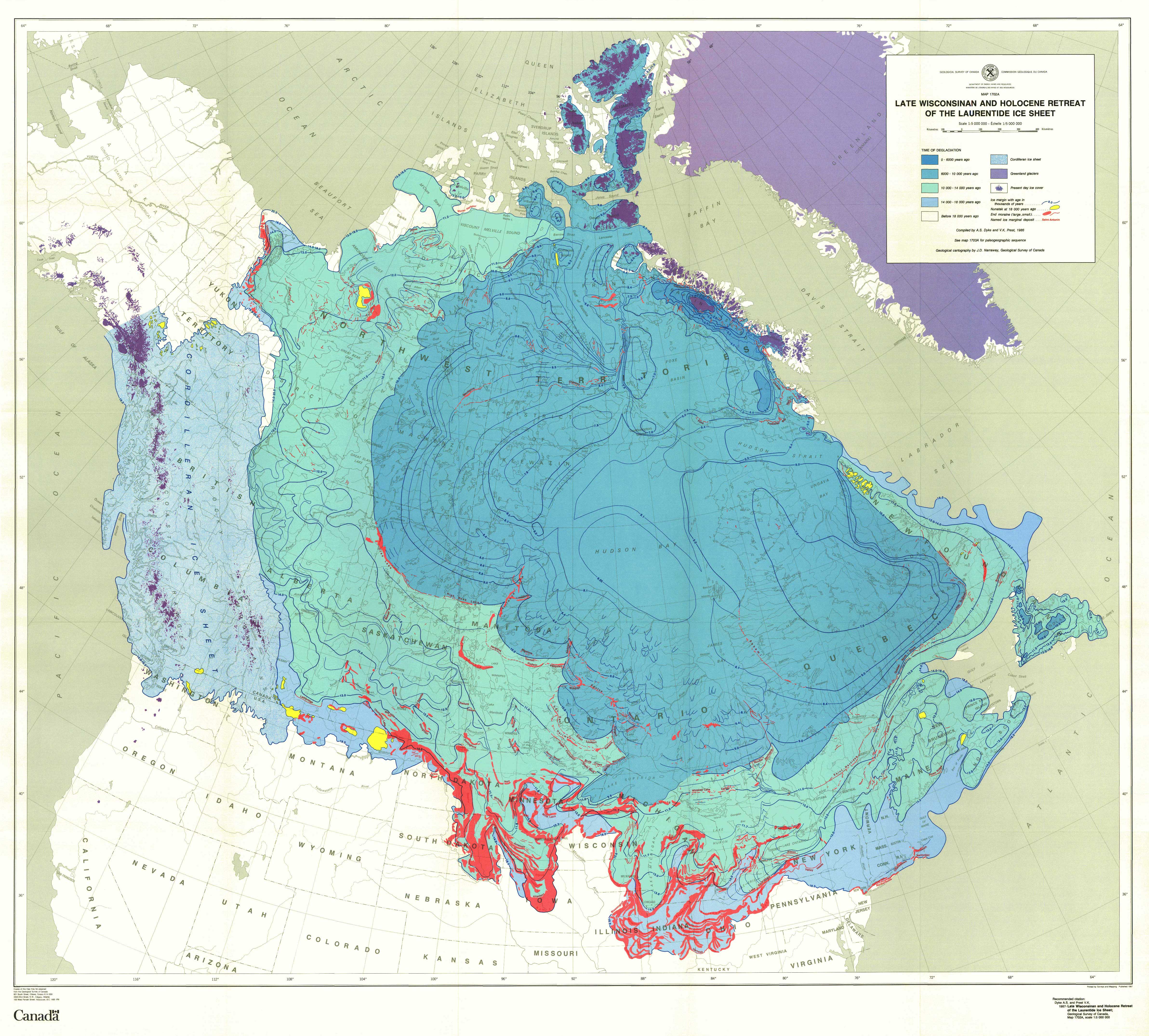


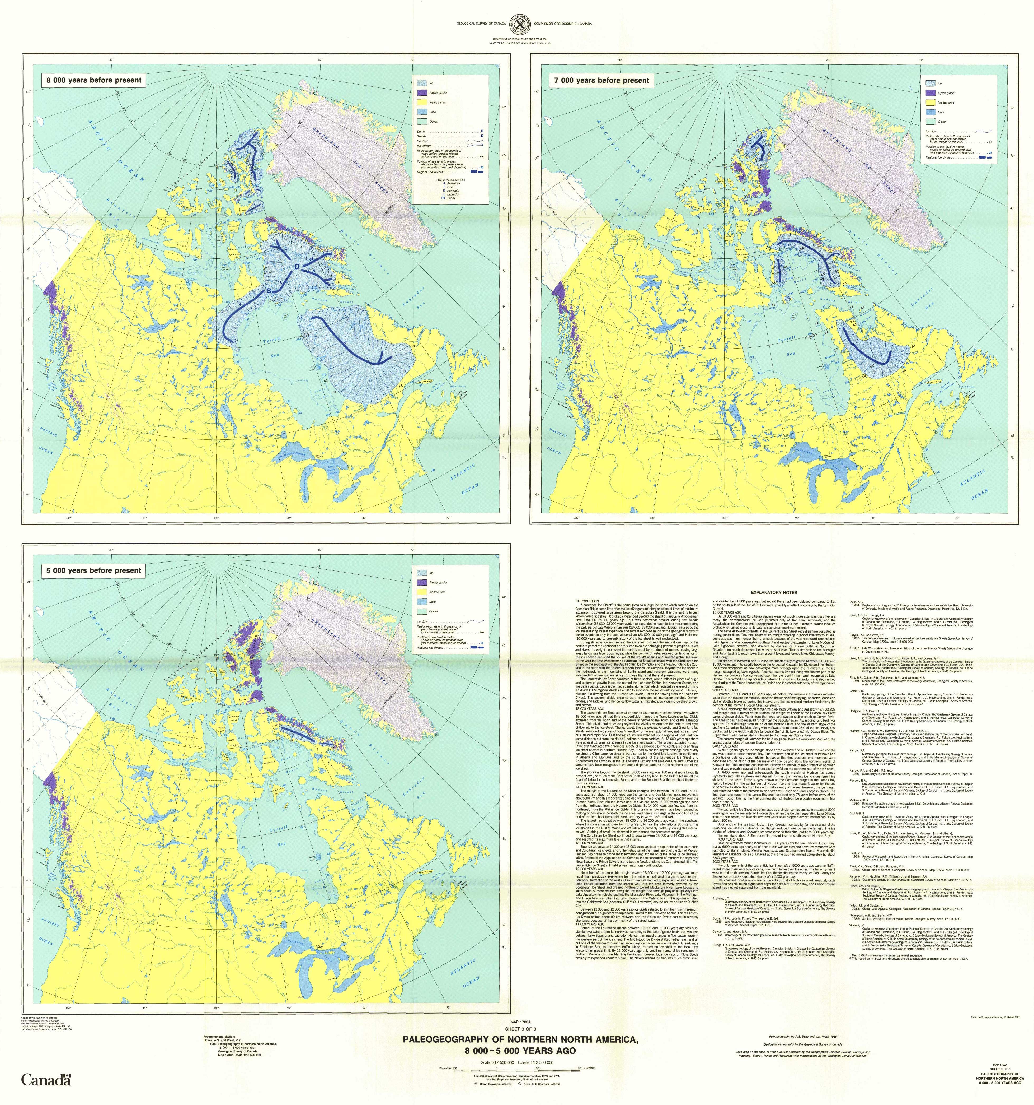
Acknowledgments
Numerous colleagues have provided the raw material, without which this report and map compilation could not have been done. We are particularly grateful to the authors of the regional chapters of the "Quaternary Geology of Canada and Greenland". We are also thankful to Drs. Lee Clayton and Richard Waitt for criticism and editing undertaken during formal review.
Notes
-
[*]
Geological Survey of Canada Contribution 51186
-
[1]
Geological Survey of Canada maps 1702A and 1703A (3 sheets) are included in the pocket of this volume.
-
[2]
See Map 1702A for names of major end moraines and drift units at the glacial limit.
-
[3]
The sea level curves ot EMERGY and GARRISON (1967) and HILL et al. (1985) are used for these areas throughout this report.
-
[4]
Hereafter all sea level data for the Prince Edward Island are from Krank.
References
- ALLARD, M. (1974): Géomorphologie des eskers abitibiens, Cahiers de Géographie de Québec, Vol. 18, p. 271-196.
- ANDREWS, J. T. (1968): Late-Pleistocene history of the Isortoq Valley, North Central Baffin Island, Canada, in J A. Sporck, ed., Mélanges de Géographie offerts à M. Orner Tulippe, Éditions J. Duclot, S. A., Gembloux I: p. 118-133.
- ANDREWS, J. T. (1970): A geomorphological study of postglacial uplift with particular reference to Arctic Canada. Institute of British Geographers, Special Publication No. 2, 156 p.
- ANDREWS, J. T. (1970): Differential crustal recovery and glacial chronology (6700-0 BP) west Baffin Island, N.W.T., Canada, Arctic and Alpine Research, Vol. 2, p. 115-134.
- ANDREWS, J. T. (1973): The Wisconsin ice sheet: dispersal centres, problems of rates of retreat and climatic implications, Arctic and Alpine Research, Vol. 15, p. 185-200.
- ANDREWS, J. T. (in press a): Quaternary geology of the northeastern Canadian Shield, In Chapter 3 of R. J. Fulton, J. A. Heginbottom and S. Funder, eds., Quaternary Geology of Canada and Greenland, Geological Survey of Canada, Geology of Canada No. 1.
- ANDREWS, J. T. (in press b): The Late Wisconsin déglaciation of the Laurentide Ice Sheet chronology and mechanisms, in H. E. Wright and W. F. Ruddiman, eds., North America and adjacent Oceans during the last deglaciation. Geological Society of America, Geology of North America, Vol. k-3.
- ANDREWS, J. T. and BARNETT, D. M. (1979): Holocene (Neoglacial) moraine and proglacial lake chronology, Barnes Ice Cap, Canada, Boreas, Vol. 8, p. 341 -358
- ANDREWS, J. T. and FALCONER, G. (1969): Late Glacial and post-glacial history and emergence of the Ottawa Islands, Hudson Bay, N.W.T. Evidence on the deglaciation of Hudson Bay, Canadian Journal of Earth Sciences, Vol. 6, p. 1263-76.
- ANDREWS, J. T. and IVES, J. D. (1972): Lateand post-glacial events (>10 000 BP) in the eastern Canadian Arctic with particular reference to the Cockburn Moraines and break-up of the Laurentide Ice Sheet, In Vasari, Hyvarinen, and Hicks, eds., Climatic Changes in Arctic Areas During the Last 10 000 yrs, p. 149-176.
- ANDREWS, J. T. and MILLER, G. H. (1979): Glacial erosion and ice sheet divides, northeastern Laurentide Ice Sheet, on the basis of distribution of limestone erratics, Geology, Vol. 7, p. 592-596.
- ANDREWS, J. T., STRAVERS, J. A. and MILLER, G. H. (1985): Patterns of glacial erosion and deposition around Cumberland Sound, Frobisher Bay and Hudson Strait, and the location of ice streams in the eastern Canadian Arctic, In M.J. Woldenberg, eds., Models in Geomorphology, Allen and Unwin, Boston, p. 93-118.
- ATTIG, J. W., CLAYTON, L. and MICKELSON, D. M. (1985): Correlation of late Wisconsin glacial phases in the western Great Lakes area, Geological Society of America Bulletin, Vol. 96, p. 1585-1593.
- AYLSWORTH, J. M. and SHILTS, W. W. (1985): Glacial features of the west-central Canadian Shield, In Current Research, Part B, Geological Survey of Canada, Paper 85-1B, p. 375-381.
- BAIL, P. (1985): Un mouvement glaciaire vers le nord-ouest dans la région de Saint-Godefroi, Gaspésie, Québec, Canadian Journal of Earth Sciences, Vol. 22, p. 1871-1876.
- BANERJEE, I. and McDONALD, B.C. (1975): Nature of esker sedimentation, In A. V. Jopling and B. C. McDonald, eds., Glaciofluvial and Glaciolacustrine Sedimentation, Society of Economie Paleontologists and Mineralogists, Special Publication 23, p. 132-154.
- BEGET, J. (in press): Low profile of the northwest Laurentide Ice Sheet, Arctic and Alpine Research.
- BELKNAP, D. F., SHIPP, R. C, and KELLEY, J. T. (1986): Depositional setting and Quaternary stratigraphy of the Sheepscot Estuary, Maine: a preliminary report, Géographie physique et Quaternaire, Vol. 40, p. 55-69.
- BELL, R. (1887): Exploration of portions of the Attawapiskat and Albany rivers, Geological Survey of Canada, Annual Report 1886, pt. G.
- BJÖRCK, S. (1985): Deglaciation chronology and revegetation in northwestern Ontario, Canadian Journal of Earth Sciences, Vol. 22, p. 850-871.
- BLAKE, W., Jr. (1966): End moraines and deglaciation chronology in northern Canada, with special reference to southern Baffin Island, Geological Survey of Canada, Paper 66-26, 31 p.
- BLAKE, W., Jr. (1970): Studies of glacial histories in Arctic Canada I: Pumice, radiocarbon dates, and differential postglacial uplift in the eastern Queen Elizabeth Islands, Canadian Journal of Earth Sciences, Vol. 7, p. 634-664.
- BORNS, H. J. W., LASALLE. P., and THOMPSON, W. B. (ed.) (1985): Late Pleistocene history of northeastern New England and adjacent Quebec, Geological Society of America, Special Paper 197, 159 p.
- BOUCHARD, M. A. and MARTINEAU, G. (1985): Southeastward ice flow in central Quebec and its paleogeographic significance, Canadian Journal of Earth Sciences, Vol.22, p. 1536-1541.
- BOULTON, G. S., SMITH, G. D., JONES, A. S. and NEWSOME, J. (1985): Glacial geology and glaciology of the last mid-latitude ice sheets, Journal of the Geological Society of London, Vol. 142, p. 447-474.
- BRODEUR, D. and ALLARD, M. (1985): Stratigraphie et Quaternaire de l'île aux Coudres, estuaire moyen du Saint-Laurent, Québec, Géographie physique et Quaternaire, Vol. 39, p. 183-187.
- BROOKES, I. A. (1977): Geomorphology and Quaternary geology of Codroy Lowland and adjacent plateaus, southwest Newfoundland, Canadian Journal of Earth Sciences, Vol. 14, p. 2101-2120.
- CALKIN, P. E. and FEENSTRA, B. H. (1985): Evolution of the Erie-basin Great Lakes, In P. F. Karrow and P. E. Calkin, eds., Quaternary evolution of the Great Lakes, Geological Association of Canada, Special Paper 30, p. 149-170.
- CHRISTIANSEN, E. A. (1979): The Wisconsinan deglaciation of southern Saskatchewan and adjacent areas, Canadian Journal of Earth Sciences, Vol. 16, p. 913-938.
- CLARK, P. U. (1985): A note on the glacial geology and postglacial emergence of the Lake Harbour region, Baffin Island, N.W.T., Canadian Journal of Earth Sciences. Vol. 22, p. 1864-1871.
- CLARK, P. U. and JOSENHANS, H. W. (1986): Late Quaternary land-sea correlations, northern Labrador and Labrador Shelf, In Current Research, Part B, Geological Survey of Canada, Paper 86-1B, p. 171-178.
- CLAYTON, L. (1983): Chronology of Lake Agassiz drainage to Lake Superior, In J. T. Teller and L. Clayton, eds., Glacial Lake Agassiz, Geological Association of Canada, Special Paper 26, p. 291-307
- CLAYTON, L. and MORAN, S. R. (1974): A glacial process-form model, In D. R. Coates, ed., Glacial geomorphology, State University of New York Publications in Geomorphology, p. 89-119.
- CLAYTON, L. and MORAN, S. R. (1982): Chronology of Late Wisconsin glaciation in middle North America, Quaternary Science Reviews, Vol. 1, p. 55-82.
- CLAYTON, L, TELLER, J. T. and ATTIG, J. W. (1985): Surging of the southwestern part of the Laurentide Ice Sheet, Boreas, Vol. 14, p. 235-241.
- CONNALY, G. G. and SIRKIN, L. A. (1973): Wisconsinan history of the Hudson-Champlain lobe, In R. F. Black, R. P. Goldthwait and H. B. Willman, eds., The Wisconsinan Stage, Geological Society of America, Memoir 136, p. 47-69.
- COTTER, J., RIDGE, J. C, EVENSON, E., SEVON, W. D., SIRINIL. L. and STUCK-ENWRATH, R. (1985): The Wisconsin history of the Great Valley. Pennsylvania and New Jersey and the age of the "Terminal Moraine ", In E. Evenson. ed., Woodfordian deglaciation of the Great Valley, New Jersey, 48th Friends of the Pleistocene Field Conference, Guidebook, Department of Geology, Lehigh University, Bethlehem, Pennsylvania, 119 p.
- CRAIG, B. B. (1965): Glacial Lake McConnell, and the superficial geology of parts of Slave River and the Redstone River map-areas. District of Mackenzie, Geological Survey of Canada, Bulletin 122, 33 p.
- DAVID, P. P. and LEBUIS, J. (1985): Glacial maximum and deglaciation of western Gaspé, Québec, Canada. In H. J. W. Borns, P. LaSaIIe, and W. B. Thompson, eds., Late Pleistocene History of Northeastern New England and Adjacent Québec, Geological Society of America, Special Paper 197, p. 85-109
- DENTON, G. H. and HUGHES, T. J. (ed.) (1981): The Last Great Ice Sheets, John Wiley and Sons, New York, 484 p.
- DIONNE, J.-C. (1986): Blocs de dolomie à stromatolites sur les rives de l'estuaire du Saint-Laurent, Québec, Géographie physique et Quaternaire, Vol. 40, p. 93-98.
- DREDGE, L. A. and COWAN, W. R. (in press): Quaternary geology of the southwestern Canadian Shield, In Chapter 3 of R. J. Fulton, J. A. Heginbottom and S. Funder, eds., Quaternary Geology of Canada and Greenland, Geological Survey of Canada, Geology of Canada, No. 1.
- DREDGE, L. A. and THORLEIFSON, H. (1987): The Middle Wisconsinan history of the Laurentide Ice Sheet, Géographie physique et Quaternaire, Vol. 41, p. 215-235.
- DREXLER, C. W., FARRAND, W. R. and HUGHES, J. D. (1983): Correlation of glacial lakes in the Superior basin with eastward drainage events from Lake Agassiz, In J. T. Teller and L. Clayton, eds., Glacial Lake Agassiz, Geological Association of Canada, Special Paper 26, p. 309-332.
- DUBOIS, J.-M. and DIONNE, J.-C. (1985): The Québec North Shore Moraine System: A major feature of Late Wisconsin deglaciation, in H. J. W. Borns, P. LaSaIIe, and W. B. Thompson, eds., Late Pleistocene History of Northeastern New England and Adjacent Québec, Geological Society of America, Special Paper 197, p. 125-133.
- DYKE, A. S. (1977): Quaternary geomorphology, glacial chronology, and climatic and sea-level history of southwestern Cumberland Peninsula, Baffin Island, Northwest Territories, Canada, Unpublished Ph.D. thesis, University of Colorado, 184 p.
- DYKE, A. S. (1979): Glacial and sea-level history of southwestern Cumberland Peninsula, Baffin Island, N.W.T., Canada, Arctic and Alpine Research, Vol. 11, p. 179-202.
- DYKE, A. S. (1984): Quaternary geology of Boothia Peninsula and northern District of Keewatin, central Canadian Arctic, Geological Survey of Canada, Memoir 407, 26 p.
- DYKE, A. S. (in press) : A reinterpretation of glacial and marine limits around the northwestern Laurentide Ice Sheet, Canadian Journal of Earth Sciences, DYKE. A. S. and DREDGE, L. A. (in press): Quaternary geology of the northwestern Canadian Shield, In Chapter 3 of R. J. Fulton, J. A. Heginbottom and S. Funder, eds., Quaternary Geology of Canada and Greenland, Geological Survey of Canada, Geology of Canada, No. 1.
- DYKE, A. S., DREDGE, L. A. and VINCENT, J.-S. (1982): Configuration and dynamics of the Laurentide ice sheet during the late Wisconsin maximum, Géographie physique et Quaternaire, Vol. 36, p. 5-14.
- DYKE, A. S. and MATTHEWS, J. V., Jr. (in press): Stratigraphy of Quaternary sediments along Pasley River, Boothia Peninsula, central Canadian Arctic, Géographie physique et Quaternaire.
- DYKE, A. S., VINCENT, J.-S., ANDREWS, J. T., DREDGE, L A. and COWAN, W. R. (in press): The Laurentide Ice Sheet and an introduction to the Quaternary geology of the Canadian Shield, In Chapter 3 of R. J. Fulton, J. A. Heginbottom and S. Funder, eds., Quaternary Geology of Canada and Greenland, Geological Survey of Canada, No. 1.
- EMERY, K. O. and GARRISON, L. E. (1967): Sea levels 7000 to 20 000 years ago, Science, Vol. 157, p. 684-687.
- ENGLAND, J. H. (1976): Late Quaternary glaciation of the Queen Elizabeth Islands, N.W.T., Canada: alternative models, Quaternary Research, Vol. 6, p. 185-202.
- ESCHMAN, D. F. and KARROW, P. F. (1985): Huron Basin glacial lakes: a review, in P. F. Karrow and P. E. Calkin, eds., Quaternary evolution of the Great Lakes, Geological Association of Canada, Special Paper 30, p. 79-93.
- EVANS, D. J. A. and ROGERSON, R. J. (1986): Glacial geomorphology and chronology in the Seslamiut Range-Nachvak Fiord area, Torngat Mountains, Labrador, Canadian Journal of Earth Sciences, Vol. 23, p. 66-76.
- FISHER, D. A., REEH, N. and LANGLEY, K. (1985): Objective reconstructions of the Late Wisconsinan Laurentide Ice Sheet and the significance of deformable beds, Géographie physique et Quaternaire, Vol. 39, p. 229-238.
- FLINT, R. F. (1943): Growth of the North American ice sheet during the Wisconsin Age, Geological Society of America Bulletin, Vol. 54, p. 325-362.
- FLINT, R. F. (1947): Glacial geology and the Pleistocene Epoch, John Wiley, New York
- FLINT, R. F. (1971): Glacial and Quaternary Geology, John Wiley.
- FULLERTON, D. S. and COLTON, R. B. (1986): Stratigraphy and correlation of the glacial deposits on the Montana plains, In V. Sibrava, D. Q. Bowen, and G. M. Richmond, eds., Glaciations in the Northern Hemisphere, Quaternary Science Reviews, Special Volume 5, Pergamon Press.
- FULTON, R. J., FENTON, M. M., and RUTTER, N. W. (1984): Summary of Quaternary stratigraphy and history, western Canada, In R. J. Fulton, eds., Quaternary stratigraphy of Canada - a Canadian contribution to IGCP Project 24, Geological Survey of Canada, Paper 84-10, p. 69-83.
- FULTON, R. J., HEGINBOTTOM, J. A. and FUNDER, S., ed. (in press): Quaternary of Canada and Greenland, Geological Survey of Canada, Geology of Canada, No. 1 (also Geological Society of America, Geology of North America, Vol. k-1).
- FULTON, R.J. and HODGSON, D. A. (1979): Wisconsin glacial retreat, southern Labrador, In Current Research, Part C, Geological Survey of Canada, Paper 79-1C, p. 17-21.
- GRANT, D. R. (1977): Glacial style and ice limits, the Quaternary stratigraphie record, and changes of land and ocean level in the Atlantic Provinces, Canada, Géographie physique et Quaternaire, vol. 31, p. 247-260
- GRATTON, D., DUBOIS, J.-M. and GWYN, H. (1986): L'île d'Anticosti a-t-elle été récemment englacée?, GEOS, Vol. 15, No. 1. p. 21-23.
- GRAY, J. T. and LAURIOL, B. (1985): Dynamics of the Late Wisconsin ice sheet in the Ungava Peninsula interpreted from geomorphological evidence, Arctic and Alpine Research, Vol. 17, p. 289-310.
- HANSEL, A. K., MICKELSON, D. M., SCHNEIDER, A. F. and LARSEN, C. E. (1985): Late Wisconsinan and Holocene history of the Lake Michigan basin, In P. F. Karrow and P. E. Calkin, eds., Quaternary Evolution of the Great Lakes, Geological Association of Canada, Special Paper 30, p. 39-53.
- HARDY, L. (1976): Contribution à l'étude géomorphologique de la portion québécoise des basses terres de la baie de James, thèse de doctorat non publiée, Université McGiII, Montréal, 264 p.
- HARDY, L. (1977): La déglaciation et les épisodes lacustre et marin sur le versant québécois des basses terres de la baie de James, Géographie physique et Quaternaire, Vol. 31, p. 261-273.
- HARINGTON, C. R. (1977): Marine mammals in the Champlain Sea and the Great Lakes, In W. S. Newman and B. Salwen, eds., Amerinds and their Paleoenvironment in northeastern North America, Annals of the New York Academy of Sciences, Vol. 228, p. 508-537.
- HILL, P. R., MUDIE, P. J., MORAN, K. and BLASCO, S. M. (1985): A sea level curve for the Canadian Beaufort Shelf, Canadian Journal of Earth Sciences, Vol. 22, p. 1383-1393.
- HILLAIRE-MARCEL, C., OCCHIETTI, S. and VINCENT, J.-S. (1981): Sakami moraine, Québec: a 500-km-long-moraine without climatic control, Geology, Vol. 9, p. 210-214.
- HODGSON, D. A., KOERNER, R. M., ENGLAND, J. H. and BEDNARSKI, J. (in press): Quaternary geology of the Queen Elizabeth Islands, In Chapter 6 of R. J. Fulton, J. A. Heginbottom and S. Funder, eds., Quaternary Geology of Canada and Greenland, Geological Survey of Canada, Geology of Canada, No. 1.
- HODGSON, D. A. and VINCENT, J.-S. (1984): A 10 000 yr. BP extensive ice shelf over Viscount Melville Sound, Arctic Canada, Quaternary Research, Vol. 22, p. 18-30.
- HODGSON, D. A., VINCENT, J.-S. and FYLES, J. G. (1984): Quaternary geology of central Melville Island, Northwest Territories, Geological Survey of Canada, Paper 83-16, 25 p.
- HOOKE, R. LeB. (1976): Pleistocene ice at the base of the Barnes Ice Cap, Baffin Island, N.W.T., Canada, Journal of Glaciology, Vol. 17, p. 49-60.
- HUGHES, J. D. (1978): Marquette buried forest 9850 years old, Abstract, American Association for the Advancement of Science Annual Meeting, February 12-17.
- HUGHES, O. L. (1972): Surficial geology of northern Yukon Territory and northwestern District of Mackenzie, Northwest Territories, Geological Survey of Canada, Paper 69-36, 11 p.
- HUGHES, O. L., HARINGTON, C. R., JANSSENS, J. A., MATTHEWS, J. V., Jr., MORLAN, R. E., RUTTER, N. W. and SCHWEGER, C. E. (1981): Upper Pleistocene stratigraphy, paleoecology, and archaeology of the northern Yukon interior, eastern Beringia, 1. Bonnet Plume Basin, Arctic, Vol. 34. p. 329-365.
- HUGHES, O. L, RUTTER, N. W., MATTHEWS, J. V., Jr. and CLAGUE, J. J. (in press): Unglaciated areas (Regional Quaternary history and stratigraphy of the Canadian Cordillera), In Chapter 1 of R. J. Fulton, J. A. Heginbottom and S. Funder, eds., Quaternary Geology of Canada and Greenland, Geological Survey of Canada, Geology of Canada, No. 1.
- HUGHES, T. J., DENTON, G. H. and FASTOOK, J. L. (1985): The Antarctic Ice Sheet: an analog for Northern Hemisphere paleo-ice sheets, In M. J. Waldenberg, ed., Models in Geomorphology, Allen and Unwin, Boston, p. 25-72.
- IVES, J. D. (1960): Former ice-dammed lakes and the deglaciation of the middle reaches of the George River, Labrador-Ungava, Geographical Bulletin, No. 14, p. 44-70.
- IVES, J. D. (1978): The maximum extent of the Laurentide Ice Sheet along the east coast of North America during the last glaciation, Arctic, Vol. 31, p. 24-53.
- IVES, J. D. and ANDREWS, J. T. (1983): Studies in the physical geography of north central Baffin Island, Geographical Bulletin, Vol. 19, p. 5-48.
- JACKSON, L. E. (1979): New evidence for the existence of an ice free corridor in the Rocky Mountain Foothills near Calgary, Alberta, during Late Wisconsinan time, In Current Research Part A, Geological Survey of Canada, Paper 79-1 A. p. 107-111.
- JACKSON, L. E., Jr. (1983): Comments on Chronology of Late Wisconsinan glaciation in Middle North America, Quaternary Science Reviews, Vol. 1, p. vii-xiv.
- JOSENHANS, H. W., ZEVENHUIZEN, J. and KLASSEN, R. A. (1986): The Quaternary geology of the Labrador Shelf, Canadian Journal of Earth Sciences, Vol. 23, p. 1190-1213.
- KARROW, P. F. (in press): Quaternary geology of the Great Lakes Region, In Chapter 4 of R. J. Fulton, J. A. Heginbottom and S. Funder, eds., Quaternary Geology of Canada and Greenland, Geological Survey of Canada, Geology of Canada, No. 1.
- KARROW, P. F. and CALKIN, P. E. (1985): Quaternary evolution of the Great Lakes, Geological Association of Canada, Special Paper 30.
- KING, G. A. (1985): A standard method for evaluating radiocarbon dates on local deglaciation: application to the deglacial history of southern Labrador and adjacent Québec, Géographie physique et Quaternaire, Vol. 39, p. 163-182.
- KING, L. H. and FADER, G. B. J. (1986): Wisconsinan glaciation of the Atlantic Continental Shelf of southeast Canada, Geological Survey of Canada, Bulletin 363, 72 p.
- KLASSEN, R. A. (1981): Aspects of the glacial history of Bylot Island, District of Franklin, In Current Research, Part A, Geological Survey of Canada, Paper 81-1A, p. 317.
- KLASSEN, R. A. and BOLDUC, A. (1984): Ice flow directions and drift composition, Churchill Falls, Labrador, In Current Research, Part A, Geological Survey of Canada, Paper 84-1 A, p. 255
- KLASSEN, R. W. (1971): Surficial geology, Brock River and Franklin Bay, District of Mackenzie, Northwest Territories, Geological Survey of Canada, Open File 48, 1: 250 000 scale.
- KLASSEN, R. W. (1983): Lake Agassiz and the glacial history of northern Manitoba, In J. T. Teller and L. Clayton, eds., Glacial Lake Agassiz, Geological Association of Canada, Special Paper 26, p. 97-115.
- KLASSEN, R. W. (1984): Dating Methods applicable to Late Glacial deposits of the Lake Agassiz Basin, Manitoba, In W. C. Mahaney, ed., Quaternary Dating Methods, Elsevier, Amsterdam, p. 375-388.
- KLASSEN, R. W. (in press): Late Wisconsinan deglaciation (Quaternary history of the southern Canadian Plains), In Chapter 2 of R. J. Fulton, J. A. Heginbottom and S. Funder, eds., Quaternary Geology of Canada and Greenland, Geological Survey of Canada, Geology of Canada, No. 1.
- KLASSEN, R. W. and VREEKEN, W. J. (1985): Quaternary geology of southwestern Saskatchewan, In Current Research, Part A, Geological Survey of Canada, Paper 85-1A, p. 187-192.
- KOERNER, R. M. (in press): Queen Elizabeth Islands glaciers, In Chapter 6 of R. J. Fulton, J. A. Heginbottom and S. Funder, eds., Quaternary Geology of Canada and Greenland, Geological Survey of Canada, Geology of Canada, No. 1.
- KOTEFF, C. and PESSL, F., Je. (1981): Systematic Ice Retreat in New England, United States Geological Survey, Professional Paper 1179, 20 p.
- KRANCK, K. (1972): Geomorphological development and post-Pleistocene sea level changes, Northumberland Strait, Maritime Provinces, Canadian Journal of Earth Sciences, Vol. 9, p. 835-844.
- LAYMON, C. A. (1986): Deglaciation of northern Ungava Peninsula, Quebec and implications for Laurentide ice dynamics, 15th Annual Arctic Workshop, Abstracts, Boulder, Colorado, p. 39-40.
- LOCKE, W. W. (1980): The Quaternary geology of the Cape Dyer area, south-easternmost Baffin Islan, Canada, Unpublished Ph.D. thesis, University of Colorado, Boulder, 332 p.
- LØKEN, O. H. (1966): Baffin Island refugia older than 54 000 years, Science, Vol. 143, p. 1378-1380.
- MATHEWS, W. H. (1974): Surface profiles of the Laurentide Ice Sheet in its marginal areas, Journal of Glaciology, Vol. 13, p. 37-43.
- MATHEWS, W. H. (1980): Retreat of the last ice sheets in northeastern British Columbia and adjacent Alberta, Geological Survey of Canada, Bulletin 331, 22 p.
- McDONALD, B. G. (1968): Glacial and interglacial stratigraphy, Hudson Bay Lowland, In P. J. Hood, ed., Earth Science Symposium on Hudson Bay, Geological Survey of Canada, Paper 68-53, p. 78-99
- MICKELSON, D. M., CLAYTON, L., FULLERTON, D. S.. and BORNS, H. W. (1983): The Late Wisconsin glacial record of the Laurentide Ice Sheet in the United States, In H. E. Wright, ed., Late-Quaternary environments of the United States, Volume 1, p. 3-37.
- MILLER, G. H. (1976): Anomalous local glacier activity, Baffin Island, Canada: pa-leoclimatic implications, Geology, Vol. 4, p. 502-504.
- MILLER, G. H. (1980): Late Foxe glaciation of southern Baffin Island, N.W.T, Canada, Geological Society of America Bulletin, Part 1, Vol. 91, p. 399-405.
- MILLER, G. H. and DYKE, A. S. (1974): Proposed extent of late Wisconsin Laurentide ice on Baffin Island, Geology, Vol. 2, p. 125-130.
- MORNER, N.-A. and DREIMANIS, A. (1973): The Erie Interstade, In R. F. Black, R. P., Goldthwait and H. B. Willman, eds., The Wisconsinan Stage, Geological Society of America, Memoir 136, p. 107-134.
- MOTT, R. J. and JACKSON, L. E. (1982): An 18 000 year palynological record from the southern Alberta segment of the classical Wisconsman "Ice-free corridor ", Canadian Journal of Earth Sciences, Vol. 19, p. 504-513.
- MULLER, E. H. and PREST, V. K. (1985): Glacial lakes in the Ontario basin, In R. F. Karrow and P. E. Calkin, eds., Quaternary Evolution of the Great Lakes, Geological Association of Canada, Special Paper 30, p. 213-229.
- OSTERMAN, L.E., MILLER, G. H. and STRAVERS, J. A. (1985): Late and mid-Foxe glaciation of southern Baffin Island, In J. T. Andrews, ed., Quaternary Environments, Eastern Arctic, Baffin Bay and western Greenland, Allen and Unwin, Boston, p. 520-545.
- PAIR, D. (1986): Reconstruction and history of ice retreat, proglacial lakes, and the Champlain Sea, central St. Lawrence Lowlands, New York, Unpublished M. Sc. thesis, University of Waterloo, Waterloo, Ontario, 200 p.
- PELLETIER, B. R. (in press): Quaternary Paleo-sealevel Map of Canada, Geological Survey of Canada, scale 1 : 5 000 000
- PIPER, D. J. W., MUDIE, P. J., LETSON, J. R. J., BARNES, N. E. and IULIUCCI, R. J. (1986): The marine geology of the inner Scotian Shelf off the south shore, Nova Scotia, Geological Survey of Canada, Paper 85-19, 65 p.
- PRAEG, D. B., MACLEAN, B., HARDY, I. A. and MUDIE, P. J. (1986): Quaternary geology of the southeast Baffin Island Continental Shelf, Geological Survey of Canada, Paper 85-14, 38 p.
- PREST, V. K. (1957): Pleistocene geology and surficial deposits, In Chapter 7 of C. H. Stockwell, ed., Geology and Economic Minerals of Canada, Geological Survey of Canada, Economic Geology Series, No. 1, 4th edition, p. 443-495.
- PREST, V. K. (1963): Red Lake-Landsdowne House area, northwestern Ontario - Surficial geology (Parts of 42, 43, 52 and 53), Geological Survey of Canada, Paper 63-6, 23 p.
- PREST, V. K. (1969): Retreat of Wisconsin and Recent ice in North America, Geological Survey of Canada, Map 1257A, scale 1 : 5 000 000.
- PREST, V. K. (1970): Quaternary Geology of Canada, In Chapter 12 of R. J. W. Douglas, ed., Geology and Economic Minerals of Canada, Geological Survey of Canada, Economic Geology Series, No. 1, 5th edition, p. 675-764.
- PREST, V. K. (1971): Geology of the Malpeque-Summerside area, Prince Edward Island, Geological Survey of Canada, Paper 71-45, 21 p
- PREST, V. K. (1972): Kouchibouquac National Park, Parks Canada, Department of Environment, Unpublished Report.
- PREST, V. K. (1973): Surficial deposits of Prince Edward Island, Geological Survey of Canada, Map 1366A.
- PREST, V. K. (1983): Canada's heritage of glacial features, Geological Survey of Canada, Miscellaneous Report 28, 119 p.
- PREST, V. K. (1984): The Late Wisconsinan glacier complex, In R. J. Fulton, ed., Quaternary Stratigraphy of Canada - a Canadian contribution to IGCP Project 24, Geological Survey of Canada, Paper 84-10, p. 22-36.
- PREST, V. K., GRANT, D. R. and RAMPTON, V. N. (1968): Glacial Map of Canada, Geological Survey of Canada, Map 1253A, scale 1 : 5 000 000.
- PREST, V. K. and NIELSEN, E. (1987): The Laurentide Ice Sheet and long-distance transport: Geological Survey of Finland, Espoo, 15, Finland, SF 02150, in INQUA Till Symposium.
- RAMPTON, V. N. (1982): Quaternary geology of the Yukon coastal plain, Geological Survey of Canada, Bulletin 317, 49 p.
- RAMPTON, V. N., GAUTHIER, R. C., THIBAULT, J. and SEAMAN, A. A. (1984): Quaternary geology of New Brunswick, Geological Survey of Canada, Memoir 416, 77 p.
- RODRIGUES, C. G. (in press): Evolution and chronology of the western Champlain Sea Basin, In N. R. Gadd. ed., Late Quaternary Development of the Champlain Sea Basin, Geological Association of Canada, Special Paper.
- RYDER, J. M. and CLAGUE, J. J. (in press): British Columbia (Regional Quaternary Stratigraphy and history), In Chapter 1 of R. J. Fulton, J. A. Heginbottom and S. Funder, eds., Quaternary Geology of Canada and Greenland, Geological Survey of Canada, Geology of Canada, No. 1.
- SCHWEGER, C. (in press): Paleoecology of the western ice-free corridor, In Chapter 7 of R. J. Fulton, J. A. Heginbottom and S. Funder, eds., Quaternary Geology of Canada and Greenland, Geological Survey of Canada, Geology of Canada, No. 1.
- SHARPE, D. R. (1984): Late Wisconsinan glaciation and deglaciation of Wollaston Peninsula, Victoria Island, Northwest Territories, In Current Research, Part A, Geological Survey of Canada, Paper 84-1 A, p. 259-269.
- SHILTS, W. W. (1977): Geochemistry of till in perennially frozen terrain of the Canadian Shield-application to prospecting, Boreas, Vol. 5, p. 203-212.
- SHILTS, W. W. (1980): Flow patterns in the central North American ice sheet, Nature. Vol. 286, p. 213-218.
- SHILTS, W. W. (1985): Geological models for the configuration, history and style of disintegration of the Laurentide Ice Sheet, In M. J. Waldenberg, ed., Models in Geomorphology, Allen and Unwin, Boston, p. 73-91.
- SHILTS, W. W., AYLSWORTH, J. M., KASZYCKI, C. A. and KLASSEN, R. A. (in press): Geomorphology of the Canadian Shield, In W. L. Graf, ed., Geomorphic Systems of North America, Geological Society of America, Geology of North America, Vol. CSV-2.
- SHILTS, W. W., CUNNINGHAM, C. M. and KASZYCKI, C. A. (1979): Keewatin Ice Sheet-re-evaluation of the traditional concept of the Laurentide Ice Sheet, Geology, Vol.7, p. 537-541
- SHORT, S. K. and ANDREWS, J. T. (submitted): Palynology of a peat profile from Arctic Bay, Baffin Island, Géographie physique et Quaternaire.
- SIM, V. W. (1960): A Preliminary account of late Wisconsin glaciation in Melville Peninsula, N.W.T., Canadian Geographer, Vol. 17, p. 21-34.
- SKINNER, R. G. (1973): Quaternary Stratigraphy of the Moose River Basin, Ontario, Geological Survey of Canada, Bulletin 225, 77 p.
- SMITH, G. W. (1985): Chronology of Late Wisconsinan deglaciation of coastal Maine, In H. J. W. Borns, P. LaSaIIe and W. B. Thompson, eds., Late Pleistocene History of Northeastern New England and Adjacent Québec., Geological Society of America, Special Paper 197, p. 29-44.
- STALKER, A. Macs (1956): The erratics train, Foothills of Alberta, Geological Survey of Canada, Bulletin 37, 28 p.
- STALKER, A. Macs (1977): The probable extent of classical Wisconsin ice in southern and central Alberta, Canadian Journal of Earth Sciences, Vol. 14, p. 2614-2619.
- STRAVERS, J. A. and MILLER, G. H. (1986): Late Foxe Wisconsin and Early Holocene chronology of glacial events in the southern Baffin region, 15th Annual Arctic Workshop, Abstracts, Boulder, Colorado, p. 65-67.
- ST-ONGE, D. A. (1984): Eskers in the Redrock Lake Region, N.W.T., a possible prospecting tool, In Contributions to the geology of the Northwest Territories, Vol. 1, p. 39-46.
- TELLER, J. T. and CLAYTON, L. (1983): Glacial Lake Agassiz, Geological Association of Canada, Special Paper 26, 451 p.
- TELLER, J. T. and THORLEIFSON, L. H. (1983): The Lake Agassiz-Lake Superior connection, In J. T. Teller and L. Clayton, eds., Glacial Lake Agassiz, Geological Association of Canada, Special Paper 26, p. 261-290.
- THOMPSON, W. B. and BORNS, H. W. (1985): Surficial geological map of Maine, Maine Geological Survey, scale 1 : 500 000.
- TIPPETT, C. R. (1985): Glacial dispersal train of Paleozoic erratics, central Baffin Island, N.W.T., Canada, Canadian Journal of Earth Sciences, Vol. 22, p. 1 SIS-IBIS.
- VEILLETTE, J. J. (1986): Former southwesterly ice flows in Abitibi-Témiscamingue: implications for the configuration of the Late Wisconsinan ice sheet, Canadian Journal of Earth Sciences, Vol. 23, p. 1724-1741.
- VEILLETTE, J. J. (in press) : Déglaciation et évolution des lacs proglaciaires post-Algonquin au Témiscamingue, Québec et Ontario, Géographie physique et Quaternaire.
- VINCENT, J.-S. (1982): The Quaternary history of Banks Island, N.W.T., Canada, Géographie physique et Quaternaire, Vol. 36, p. 209-232.
- VINCENT, J.-S. (1983): La géologie du Quaternaire et la géomorphologie de l'île Banks.
- Arctique Canadien, Commission géologique du Canada, Mémoire 405, 118 p.
- VINCENT, J.-S. (in press a): Quaternary geology of the northern Interior Plains of Canada, In Chapter 2 of R. J. Fulton, J. A. Heginbottom and S. Funder, eds., Quaternary Geology of Canada and Greenland, Geological Survey of Canada, Geology of Canada, No. 1.
- VINCENT, J.-S. and HARDY, L. (1979): The evolution of glacial lakes Barlow and Ojibway, Quebec and Ontario, Geological Survey of Canada, Bulletin 316, 18 p.
- VINCENT, J.-S. and HARDY, L. (in press b): Quaternary geology of the southeastern Shield, in Chapter 3 of R. J. Fulton, J. A. Heginbottom and S. Funder, eds., Quaternary Geology of Canada and Greenland, Geological Survey of Canada, Geology of Canada, No. 1.
- WILSON, J. T., FALCONER, G., MATHEWS, W. H. and PREST, V. K. (1958): Glacial Map of Canada, Geological Association of Canada, scale 1 : 5 000 000.
- WRIGHT, H. E. (1972): Quaternary history of Minnesota, In P. K. Sims and G. B. Morey, eds., Geology of Minnesota: A Centennial Volume, Minnesota Geological Survey, p. 515-578.
- WRIGHT, H. E., MATSCH, C. L. and CUSHING, E.-J. (1973): Superior and Des Moines lobes, In R. F. Black, R. P. Goldthwait and H. B. Willman, eds., The Wisconsinan Stage, Geological Society of America, Memoir 136, p. 153-185.
- WRIGHT, H. E. and RUHE, R. V. (1965): Glaciation of Minnesota and Iowa, In H. E. Wright and D. G. Frey, eds., The Quaternary of the United States, Princeton, New Jersey, Princeton University Press, p. 29-41.
- WYATT, P. H. and THORLEIFSON, L. H. (1986): Provenance and geochronology of Quaternary glacial deposits in the central Hudson Bay Lowland, Northern Ontario, 15th Annual Arctic Workshop, Abstracts, Boulder, Colorado, p. 79.
 10.7202/021195ar
Liste des figures
A
B
C
D
Changing time-distance interpretations of the Laurentide Ice Sheet 1970-1986. S, N, etc. refer to the south and north margins, etc. ; e, m, and I refer to Early, Middle and Late Wisconsinan advances.
Modifications (en 4 phases) apportées à l'interprétation des limites spatio-temporelles de la calotte glaciaire laurentidienne (1970-1986). S, N, etc. se rapportent aux marges sud, nord, etc.; e, m et I se rapportent aux récurrences survenues au Wisconsinien inférieur, moyen et supérieur.
Figure 2
Two types of large dispersal trains formed by the Late Wisconsinan Laurentide Ice Sheet. The Dubawnt Type formed under normal regional flow, the Boothia Type formed by an ice stream. Areas A and B on figures are different bedrock types, arrow indicate ice flow and dotted areas indicate zone of dispersal of rock type A.
Deux grands types d'épandages de blocs glaciaires (traînes de débris) produits par la calotte glaciaire laurentidienne. Le type Dubawnt mis en place sous un écoulement glaciaire d'origine régionale; le type Boothia mis en place par une langue glaciaire. Les zones A et B représentent deux types de roches en place; la flèche donne la direction de l'écoulement glaciaire; Les parties en pointillé identifient les zones de dispersion du type de roche A.
Figure 3
Three major landscape zones of the Laurentide Ice Sheet. Zone 1 has extensive end moraines, hummocky moraine, and ice thrust masses as well as several generations of ice flow lineaments; Zone 2 has well developed (long) eskers and contemporaneous ice flow lineaments; Zone 3 has extensive ribbed moraine formed in association with drumlins and flutings and with eskers.
Les trois grandes régions de la calotte glaciaire laurentidienne. La région n° 1 renferme de grandes moraines frontales, des moraines bosselées, des masses de poussée glaciaire ainsi que plusieurs générations d'alignements d'écoulement glaciaire. La région n° 2 contient de longs eskers bien élaborés et des alignements d'écoulement glaciaire contemporains. La région n° 3 comprend des moraines rubanées étendues qui se sont formées en association avec des drumlins et des rainures, ainsi que des eskers.
Map 1702A