
Résumés
Abstract
In the St. Lawrence Valley just west of Québec City, initial deglaciation was accompanied by an energetic northward discharge of meltwater into a body of water, possibly subglacial, that was present in the axis of the valley. At Pointe Saint-Nicolas, a thick (> 35 m) ice-proximal sandy subaqueous fan was deposited during this event. The subaqueous fan is composed primarily of northwest-dipping turbidite sheets, with minor hyperconcentrated underflow channel fills and gravel-outwash deposits. By 11 200 14C BP, subaqueous fan sedimentation had stopped, and massive to rhythmically interbedded glaciomarine muds were being deposited. Introduction of muds into the basin promoted subaqueous slope failure and debris flowing locally. Between 10 950 and 10 800 14C BP, the Laurentide Ice Sheet readvanced southward onto the south shore, and deposited the subglacial St. Nicolas Till. With continued isostatic rebound and associated forced regression, tidal currents began to rework emergent coastal zones, and fluvial systems started to incise their valleys.
Résumé
Pendant la phase initiale de la déglaciation de la vallée du Saint-Laurent, dans la région à l’ouest de la ville de Québec, des eaux de fonte à haute énergie se sont déversées vers le nord dans une masse d’eau très probablement sous-glaciaire localisée dans l’axe de la vallée. Ce déversement est à l’origine d’un cône sableux de turbidité à pendage nord-ouest, associé à des dépôts de courants de fond hyperconcentrés et à des graviers et galets d’épandage proglaciaire. Vers 11 200 14C BP, des boues glaciomarines massives et des lits intercalés de rythmites sont déposés dans l’axe de la vallée enfoncée par glacioisostasie. Cet apport de boues marines engendre localement des glissements sous-aquatiques et des coulées de débris sur les pentes immergées. Entre 10 950 et 10 800 14C BP, l’Inlandsis laurentidien a progressé de nouveau jusque sur la rive sud de l’actuel Saint-Laurent et déposé le till sous-glaciaire de Saint-Nicolas. Les courants de marée ont ensuite remanié les littoraux progressivement émergés par relèvement glacioisostatique. Les réseaux fluviatiles ont commencé à inciser des vallées, en érodant et redéposant les dépôts antérieurs.
Resumen
En el valle del San Lorenzo justo al oeste de la ciudad de Quebec un deshielo precoz fue acompañado de una descarga enérgica de agua de fusión en dirección norte hacia un cuerpo de agua probablemente subglacial ya presente en el eje del valle. En Punta San Nicolas ese derrame dio origen a un depósito arenoso próximo al hielo de un espesor de 35 m en forma de cono. Dicho cono subacuático esta compuesto en primer lugar por capas de turbit del noroeste asociados en lo alto con corrientes de fondo hiperconcentradas y aluvión de grava. Hace aproximadamente 11 200 14C BP, la sedimentación del cono subacuático se detuvo y simultáneamente cantidades masivas de lodos glaciomarinos fueron depositados de manera rítmica. La introducción de lodo en la cuenca provocó la fractura de la pendiente subacuática y conllevo la acumulación de desechos localmente. Entre 10 950 y 10 800 14C BP, La Capa glacial Lorenzana avanzó nuevamente en dirección sur hasta la rivera originando el depósito subglacial de las tillitas de San Nicolas. Posteriormente, las corrientes de mareas fueron definiendo el litoral emergente mientras que el sistema fluvial fue provocando la ablación de los valles.
Corps de l’article
Introduction
The deglacial history of the Québec City region is poorly understood, and has proven difficult to integrate into larger basin-scale deglacial models of the St. Lawrence Valley (LaSalle et al., 1977; Chauvin et al., 1985; Parent and Occhietti, 1988, 1999; Occhietti et al., 2001b). During deglaciation, the greater Québec City region acted as a gateway for major meltwater discharges into the Atlantic Ocean (Parent and Occhietti, 1988, 1999; Rodrigues and Vilks, 1994), experienced complex ice margin fluctuations (Blais and Shilts, 1989; LaSalle and Shilts, 1993; Fournier, 1998; Paradis and Bolduc, 1999; Bhiry et al., 2001), was transgressed by the Champlain Sea (Occhietti et al., 2001a), and underwent a subsequent episode of isostatic rebound and base level fall that forced shorelines to regress to their present day position. With limited bedrock striation and glacial landform data in regions below the Champlain Sea maximum (~200 m asl), these events are poorly constrained in time and space. In an attempt to provide insight into the deglacial history of the Québec City region, this paper investigates the sedimentology of a well-exposed outcrop in a sand pit at Pointe Saint-Nicolas that has served as the de facto type section for the Québec City region.
The Pointe Saint-Nicolas site is located in the axis of the St. Lawrence Valley ~10 km west of Québec City on the south shore of the St. Lawrence River (Fig. 1). Topography on the valley floor slopes gently northward (< 1o) towards a ~50 m high bedrock cliff that lines the south shore. The sand pit is perched in a knickmark cut into the bedrock cliff. Bedrock in the Québec City region can be divided into three major provinces, as follows: 1) granitoid rocks of the Precambrian Shield, which outcrop on the north shore of the St. Lawrence River, 2) carbonate mudstones and wackestones of the St. Lawrence Platform, which occur in the axis of the valley, and 3) volcanic, carbonate, and siliciclastic rocks of the Appalachian orogen, which outcrop on the south shore of the St. Lawrence River (Fig. 1).
Stratigraphy and Previous Work
The initial Quaternary stratigraphic framework for the Québec City region (Fig. 2) was established by LaSalle (1984, 1989). He distinguished two subglacial tills deposited prior to the last deglaciation (Pointe Saint-Nicolas and Québec City Tills) with intervening silt, sand and gravel, which he grouped under the Anse-aux-Hirondelles Formation, and muddy varves which he called the Beaupré Formation. The uppermost till is overlain by undifferentiated Champlain Sea mud, sand and gravel. At a later date, he identified a Late Wisconsinan fossiliferous diamicton intercalated with the Champlain Sea deposits called the St. Nicolas Till (LaSalle and Shilts, 1993). Radiocarbon dates ranging between 28 375 14C BP (UGa-463) and > 42 000 14C BP (GSC-3420) obtained from plant macrofossils from Subunit 1 of the Anse-aux-Hirondelles Formation (Fig. 3) have been used to infer a Middle Wisconsinan age for the entire Anse-aux-Hirondelles Formation. A reworked Balanus hameri fossil collected from the St. Nicolas Till at the site has yielded a date of 11 200 BP (GSC-1476; LaSalle and Shilts, 1993). All of the units outlined in this stratigraphic framework have been previously identified at the Pointe Saint-Nicolas site, with the notable exception of the Québec City Till (Fig. 3).
LaSalle (1984, 1989) proposed a correlation between the Quaternary stratigraphy of the Québec City region and the more extensively studied Quaternary stratigraphy of the Central St. Lawrence Valley established by Gadd (1971). Specifically, he correlated the Pointe Saint-Nicolas and Bécancour tills, the Anse-aux-Hirondelles Formation and the St. Pierre Sediments, the Beaupré and Deschaillons Varves, and the Québec City and Gentilly tills (Fig. 2). Recent revisions to the stratigraphic framework in the Central St. Lawrence Valley (Lamothe, 1989; Occhietti et al.,1996; see Fig. 2) were not available to LaSalle when he proposed his basin-scale correlations (1984, 1989). These revisions have been extended in part to the Québec City region; for example, the Beaupré Formation is now correlated with the St. Maurice Rhythmites (Occhietti, 1990). The applicability of the revised framework of Occhietti et al. (1996) to the Québec City region will be commented on briefly in the discussion section.
Deglaciation of the St. Lawrence Valley
Québec City is located between two regions of the St. Lawrence Valley with contrasting Late Wisconsinan deglacial histories. Deglaciation east of Québec City was marked by the development of a northeast flowing ice stream in the valley axis. Between ~13 500 and ~12 000 14C BP, an arm of marine water, possibly in the form of a calving bay (Thomas, 1977), migrated inland against the ice stream from the Atlantic Ocean to at least the Saguenay River and possibly to a position near Québec City, forming the Goldthwait Sea (Stea et al., 1998; Occhietti et al., 2001b). This effectively isolated a large ice mass over the Appalachians from the Laurentide Ice Sheet (LaSalle et al., 1977; Chauvin et al., 1985). Glacial landform and sedimentological data suggest that the Appalachian ice mass extended as far west as the Bois Francs region (Fig. 1).
In contrast, in regions west of Québec City the Laurentide Ice Sheet receded northward as a single sheet, and deposited a series of end moraines and eskers on the Appalachian uplands (Fig. 1). Here, ice-ponded lakes formed between the ice front and the Appalachian Mountains. The last glacial lake, Lake Candona, extended > 350 km up the St. Lawrence Lowlands west of the Bois Francs region (Parent and Occhietti, 1988, 1999). At some time between 12 000 and 11 500 14C BP, Lake Candona drained into the Goldthwait Sea, dropping somewhere between 18 to 60 m in the process (Parent and Occhietti, 1988; Rodrigues and Vilks, 1994). Mixing of the marine waters with residual freshwater in the former Lake Candona basin formed the Champlain Sea. The next conclusive ice margin position north of moraines on the Appalachian uplands is the St. Narcisse Moraine (Fig. 1), which was deposited on the north shore of the St. Lawrence River by the Laurentide Ice Sheet at ~10 800 14C BP (LaSalle and Elson, 1975). The period of deglaciation between the draining of Lake Candona (12 000-11 500 14C BP) and the St. Narcisse Moraine event (~10 800 14C BP), which is the interval being investigated in this paper, is very poorly understood. Radiocarbon ages from marine shells are presented in 14C years before present (BP) and are reservoir corrected (13C = 0 ‰), as used in previous papers dealing with the Champlain Sea.
Figure 1

Location of the Pointe Saint-Nicolas pit, major deglacial landforms, and bedrock provinces in the greater Québec City region of the St. Lawrence Valley (from Chauvin et al., 1985; Globensky, 1987; Parent and Occhietti, 1988).
Localisation de la sablière de la pointe Saint-Nicolas, emplacement des principales moraines et limites des provinces géologiques de la région de Québec (d’après Chauvin et al., 1985 ; Globensky, 1987 ; Parent et Occhietti,1988).
Methodology
Field work was carried out in the summer and fall of 1998, when the Pointe Saint-Nicolas pit was relatively well exposed (Fig. 4). Vertical sections were cleared, and spraypaint was used to trace contacts laterally. Graphic logs of the vertical sections were drawn, noting sedimentary textures, types and orientations of sedimentary structures, and the nature and orientation of contacts. Following the field season, beds or groups of beds with similar characteristics were grouped together, and a list of sedimentary facies was compiled. Facies were then grouped together into facies associations (FAs). Facies within a facies association are related in that they represent various components of a common depositional system.
Figure 2

Proposed Quaternary stratigraphic frameworks for the Québec City area (modified from LaSalle, 1984, 1989; LaSalle and Shilts, 1993).
Cadre stratigraphique proposé pour la région de Québec (modifié de LaSalle, 1984, 1989 ; LaSalle et Shilts, 1993).
Sedimentary Facies and Interpretation
A total of eight sedimentary facies were identified from vertical sections cleared along the 50 m high by 150 m long south wall of the Pointe Saint-Nicolas pit (Fig. 5). Facies descriptions and interpretations are presented in detail below, and in abridged format in Table I.
Facies 1: Mud with Rare Pebbles
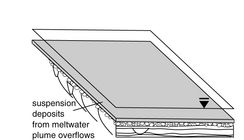
Facies 1 is composed of massive gray and olive coloured mud with rare pebble or cobble clasts (< 10 %) and occasional thin (< 1 mm) horizontal sandy partings (Fig. 6a). Lower contacts are gradational, draped or intercalated. Clasts are commonly striated, and are of mostly carbonate wackestone and mudstone lithology, with minor percentages of red shale, granitoid, and sandstone (Fig. 7a). A very low-density, low-diversity faunal assemblage consisting of Balanus hameri and Portlandia arctica is present. Shells are typically articulated and are occasionally in growth position.
Figure 3

Previous descriptions of the Pointe Saint-Nicolas section (from LaSalle et al., 1977 and LaSalle 1989).
Descriptions antérieures de l’affleurement de la pointe Saint-Nicolas (d’après LaSalle et al.,1977; LaSalle, 1984).
Interpretation: Glacial marine suspension deposits. These muds are interpreted to have settled out of subaqueous suspension from turbulent meltwater overflows or interflows. The thin (< 1 mm) sandy partings may record the transition from traction to suspension sedimentation, or possibly slightly more vigorous overflowing. Striated clasts are interpreted to be melt-out debris deposited from either seasonal sea ice or icebergs. The low-density, low-diversity fossil assemblage with Portlandia arctica suggests deposition in a cold, deep-water, low-salinity glaciomarine environment (Hillaire-Marcel, 1980). Interstratification, which is commonly pervasive in modern tidewater glaciomarine settings, is absent in these muds (thin sandy partings notwithstanding), suggesting that tidal, seasonal, and/or other factors that can cause stratification in glaciomarine deposits did not significantly affect deposition of this facies.
Facies 2: Stratified Fine Sand and Mud
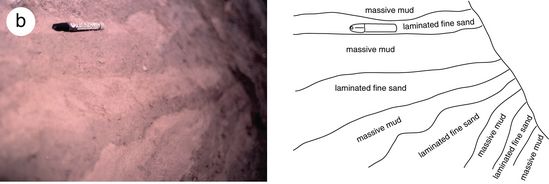
Facies 2 is composed of thinly interbedded fine sand and pebbly mud (Fig. 6b). Mud/sand couplets are between 4-20 cm thick, with an average of ~10 cm. The mud beds are massive, have a grayish to olive brown colour, and contain rare (< 10 %) pebble and cobble clasts. Clasts, particularly those of gray carbonate mudstone and wackestone lithology, are often striated. Rare Portlandia arctica are present in the mud beds. The fine sand beds are massive to vaguely laminated, and contain no shells or pebbles. Both fine sand and mud beds are ungraded. Contacts between sand and mud interbeds are typically sharp and non-erosional.
Interpretation: Glacial marine suspension deposits with superimposed seasonal and/or other cyclical influence. The interstratified sands and muds are interpreted as being deposited by suspension settling from turbid meltwater plume overflows in quiet glaciomarine water with seasonal and/or other factors that can cause rhythmicity and stratification (Phillips et al., 1991; Cowan et al., 1999). Although previously interpreted by LaSalle (1984) as glaciolacustrine varves of the Beaupré Formation (see Figs. 2 and 3), the presence of rare Portlandia arctica shells indicates that this facies was deposited in a glaciomarine environment (Hillaire-Marcel, 1980). In modern temperate glaciomarine environments, similar interbedded facies have been interpreted as glaciomarine varves formed by seasonal changes in meltwater discharge and iceberg activity (Cowan et al., 1999). If this facies is varved, sedimentation rates would have been high during deposition, ranging between 40-200 m per 1000 years. This estimate, although seemingly high, falls well within the range of sedimentation rates in modern temperate glaciomarine environments, which can reach several decametres of sediment deposited from suspension per year (Cowan and Powell, 1991).
Facies 3: Normally Graded Sand
Beds of well sorted normally graded sand account for 90 % of the sediment exposed in the lower 35 m of the Pointe Saint-Nicolas pit (Fig. 4). Beds are 5 to 100 cm thick. Lower bedding contacts are roughly flat, and can be erosional or non-erosional. Beds typically consist of a conformable succession of subfacies, the most common being (bottom to top) horizontally laminated medium sand to climbing unidirectional ripple cross-stratified fine sand to a wavy laminated mud drape (Fig. 6c). Beds are sheet-like, dip gently to the northwest (5-12o), pinch out laterally over several decametres, and thin slightly towards the northwest (Fig. 4). Ripple and small scale (< 15 cm) dune cross-stratification consistently dips towards the northwest. Pebble and small cobble are very rare, but when present lie along basal contacts. No shells or organics were observed in normally graded sand sheets in the lower 35 m of the pit.
Normally graded sand sheets also occur in the upper 15 m of the pit. Here, beds are 10 to 20 cm thick, and typically fine up from granule-rich coarse sand with shell hash (Balanus hameri >> all other species) to medium coarse sand. Lower bedding contacts are roughly flat, and can be erosional or non-erosional. Beds have a crude horizontal stratification. Northwestward dipping small-scale dune cross-strata were observed in one location.
Interpretation: Turbidites. The normal grading, climbing ripples, and Bouma Tbcd subfacies successions are suggestive of deposition from waning subaqueous turbulent gravity flows (Middleton, 1993; Hiscott et al., 1997; Shanmugan 1996, 1997). In the lower 35 m of the pit, the 5-12o northwest dip of bedding surfaces, northwest paleoflows, northwest thinning and fining trends, and sheet-like bed geometries suggest that the turbidity currents were unconfined, and flowed and decelerated down a gently inclined depositional surface towards the northwest. Rare gravel clasts located at the base of beds are interpreted to have been transported as rolling bedload at the base of the turbid underflows (Hiscott et al., 1997). Lack of obvious flow-rafted clasts or massive beds suggests that the flows had little strength coming from grain support mechanisms other than fluid turbulence (Middleton and Southard, 1984; Middleton, 1993; Shanmugan, 1996, 1997). These features imply that grain-to-grain contacts were negligible, which in turn implies that sediment concentrations in the turbidity currents were low (probably < 9 % sediment per unit volume — cf. Bagnold, 1954).
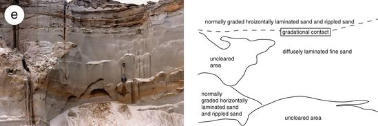
Facies 4: Diffusely Laminated Sand
Diffusely laminated sand (Fig. 6d,e) accounts for ~10 % of the sediment in the lower 35 m of the Pointe Saint-Nicolas pit. This facies is composed of very well sorted fine grained sand with rare to occasional pebbles (maximum diameter = 2 cm). Individual laminae are typically 0.25-3 cm thick, very gently curved to flat based, and are roughly horizontal. Gradational contacts between laminae give the facies a “diffusely” stratified appearance (Fig. 6d). The diffusely laminated sands infill broad, shallow, erosively based channels (maximum 20 m wide by 5 m deep; Fig. 6e). Channel fills do not appear to fine or coarsen upwards. Channels exposed at the north end of the pit tend to contain fewer pebbles than channels at the south end of the pit. The top contacts of channels are typically flat, and can be either sharp, gradational over < 10 cm into normally graded sands, or loaded. No shells or organics were observed in this facies.
Figure 4

Pointe Saint-Nicolas pit, portion of the south wall. Paleoflows throughout the section are towards the right (northwest).
Vue partielle de la paroi sud de la sablière Saint-Nicolas. Les structures de paléocourants sont orientées vers la droite (nord-ouest).
Figure 5

Sedimentology and facies associations (FAs), Pointe Saint-Nicolas pit. Sédimentologie et associations de faciès (FAs) de la sablière de la pointe Saint-Nicolas.
Figure 6
a

b
c

d

e
f

g

h

Facies – (a) Mud with rare pebbles (Facies 1); (b) Stratified mud and sand (Facies 2); (c) Normally graded sand (Facies 3); .(d) Diffusely laminated sand (Facies 4); (e) Diffusely laminated sand channel fill (Facies 4); (f) Homogeneous diamicton (Facies 5); (g) Heterogeneous diamicton (Facies 6); (h) Matrix-poor gravel (Facies 7).
Faciès – (a) Silt argileux avec quelques cailloux (faciès 1); (b) faciès stratifié de silt argileux et sable (faciès 2); (c) sable à granoclassement normal (faciès 3); (d) sable à stratification fine et diffuse (faciès 4); (e) chenal rempli de sable à stratification fine et diffuse (faciès 4); (f) diamicton homogène (faciès 5); (g) diamicton hétérogène (faciès 6); (h) gravier à matrice faible (faciès 7).
Table I

Facies
Figure 7
a

b
Clast (a) lithologies and (b) fabrics from various facies. For clast fabrics, the average A/B plane is indicated by the dashed line, with the dot representing the A axis orientation. Each clast fabric stereoplot is an average of the orientation of 50 clasts.
Lithologie (a) et fabriques (b) de différents faciès. Pour les fabriques établies avec 50 fragments, l’orientation moyenne du plan A/B est indiquée par une ligne brisée ; l’orientation moyenne de l’axe A est représentée par un point noir.
Interpretation: Hyperconcentrated underflow deposits. The typically well sorted nature of the diffusely laminated sands suggests that the sediments underwent substantial hydraulic sorting prior to deposition. Subtle centimetre-scale “diffuse” stratification suggests that the channel fills were not deposited in a single en-masse event. Gradational contacts between successive laminae, as well as the absence of pebble lags along lamination planes, suggests that laminae-depositing ‘events’ were largely non-erosive. Gradational contacts between laminae also suggest that sedimentation was continuous throughout channel filling.
The diffusely laminated channel fills at Pointe Saint-Nicolas are interpreted to have been deposited quickly by steady hyperconcentrated underflows. Hyperconcentrated flows have sediment concentrations (20-40 % sediment per unit volume; Beverage and Culberston, 1964), flow dynamics, and sediment support mechanisms that are intermediate between clear water flows and debris flows. The diffuse stratification of Facies 4 is similar to lamination formed experimentally when upper plane bed is subjected to an intense rain of sediment from suspension (Arnott and Hand, 1989). Diffusely laminated channel fills are often observed in glacial and deep-sea fans (Rust, 1977; Lowe, 1982; Postma et al., 1983; Gorrell and Shaw, 1991; Kneller and Branney, 1995; Barnett et al., 1997), and are commonly deposited by lahar-related hyperconcentrated streamflows in volcaniclastic environments (Pierson and Scott, 1985; Smith, 1986; Best, 1992; Vallance, 2000).
It is hypothesized that the slight grain size changes that define each diffuse lamina are related to vertical (Middleton, 1970; Druit, 1995) and/or lateral segregation (Hand, 1997; Vallance, 2000) of grain populations that existed within the parental flows. Absence of cross-stratification in the channel fills may indicate that turbulent flow separation, which is believed to initiate and maintain ripple and dune bedforms (Raudkivi, 1963), was suppressed due to high suspended sediment concentrations (Middleton and Southard, 1984; Smith, 1986; Best, 1992). The occasionally observed loading along the upper contact suggests that the grain framework was metastable following deposition. Loading features are often observed along the tops of subaerial hyperconcentrated flow deposits (Vallance, 2000). Lack of coarsening or fining upward trends in the channel fills suggest that flow was relatively steady during channel filling events (Kneller and Branney, 1995).
Facies 5: Homogeneous Matrix Supported Muddy Diamicton
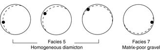
Facies 5 is composed of massive gray coloured diamicton with a homogeneous fine sandy mud matrix (Fig. 6f). The bed (there is only one) is 2-4 m thick and extends discontinuously across the south wall of the pit (Fig. 5). The lower contact is typically sharp and either flat or very gently undulating on a decametre scale. Wisps of material from underlying beds are locally folded up into the diamicton along the basal contact. Underlying material is typically undisturbed, but occasionally is ductilely folded (see sections 1 and 2 in Fig. 5). (At a nearby pit, the lower contact of the diamicton is thrust faulted [Cummings, 2000].) The diamicton contains rare to occasional broken shells of Balanus hameri and very rare Portlandia arctica. Clasts range from granule to small boulder, and are often striated. Clasts are almost entirely of carbonate mudstone and wackestone lithology (Fig. 7a). Clast A/B planes dip shallowly toward the north to northwest (Fig. 7b).
Interpretation: Subglacial till. Facies 5 is interpreted to be a subglacial till deposited by grounded ice that flowed roughly southward across Pointe Saint-Nicolas. Injection of underlying sands up across the basal contact, as observed in this facies, is a common feature of subglacial tills (Dreimanis, 1988; Iverson et al., 1997). The folded nature of the injections suggests that subglacial deformation was largely ductile, although thrust faulting in adjacent pits suggests that brittle deformation occurred locally. The muddy matrix and presence of a glaciomarine fossil assemblage (Hillaire-Marcel, 1980) indicates that the diamicton is derived mainly from underlying glaciomarine mud (Facies 1 and 2). However, the relatively high abundance of carbonate mudstone and wackestone clasts in Facies 5 (Fig. 7a) suggests at least partial derivation from the carbonate mudstone and wackestone rich St. Lawrence Platform (Fig. 1).
Facies 6: Heterogeneous Clast- to Matrix-supported Muddy Diamicton
Heterogeneous diamicton occurs in the top ~15 m of the outcrop as thin sheets and as channel fills (Fig. 6g). Channel bases are erosive, and have rare local matrix-free pipes with vertical clast fabrics. Sheets of heterogeneous diamicton pinch out on a decametre scale, and have lower contacts that are flat and sharp. The diamicton is heterogeneous in that matrix texture, as well as clast content, clast support, and clast fabric can vary over small vertical and horizontal distances. The matrix ranges from fine sandy mud to muddy coarse sand. Clasts range from pebble to small boulder (average diameter ~4 cm; maximum diameter ~60 cm), and are often striated and covered with Balanus hameri fragments.
Interpretation: Subaqueous debris flow deposits. The marked spatial changes in matrix texture, clast fabric and matrix support, lack of grading, presence of larger clasts, and occasional dewatered lower contact suggests that the heterogeneous diamicton was deposited rapidly from subaqueous muddy debris flows (Middleton and Southard, 1984; Postma, 1986). Mud in the matrix may have added considerable buoyant strength to the flows, which, along with bed-normal dispersive pressure and possibly elevated pore pressures, would have helped raft larger outsized clasts (Rodine and Johnson, 1976; Hampton, 1979; Iverson, 1997). Pipe-like zones in the diamicton with little matrix and vertical clast fabrics are associated with dewatering of the underlying sediments, and are interpreted to be elutriation pipes (Lowe, 1975; Druitt, 1995). The abundance of clasts covered with Balanus hameri basal plates suggests that the debris flows were derived from the colonized subaqueous flanks of the basin.
Facies 7: Matrix-poor Gravel
This facies is composed of clast-supported pebbles and cobbles (Fig. 6h). The gravel is generally matrix-poor and moderately sorted. Any matrix material present is typically poorly sorted muddy coarse sand. Beds are sheet-like, 20-150 cm thick (where bed thickness is discernable), and pinch out laterally over several decametres. Beds are typically inversely graded (Fig. 6h), although ungraded and normally graded beds occur. Clasts are unstriated and are sub- to well rounded. Clast A/B planes are inclined towards the southeast (Fig. 7b). No shells or organics were observed.
Interpretation: Subaqueous outwash deposits. The sheet-like nature of the beds suggests that the parental flows were unconfined on at least a decametre scale. Lack of cross-stratification indicates that flow separation and bedform development did not occur. Absence of striated clasts and the matrix-poor nature of the facies suggest that the gravels were hydraulically sorted prior to deposition. The southeast inclination of the clast A/B planes (Fig. 7b) suggests that the gravel was deposited by flows moving towards the northwest.
Although inversely graded beds are typically ascribed to kinetic sieving or (erroneously — J. Vallance, personal communication, 2001) dispersive pressure sorting mechanisms in highly concentrated flows (Bagnold, 1954; Middleton, 1970), the inversely graded gravel beds at Pointe Saint-Nicolas are interpreted to have been deposited as tractional bedload by flows where coarser bedload grains lagged behind finer bedload grains. Progressive deposition from such flows would theoretically produce an inversely graded bed (Hand, 1997; Vallance, 2000). Although grainflowing can produce inversely graded beds (Bagnold, 1954), pure gravitationally-driven grainflowing would have been unlikely at Pointe Saint-Nicolas, as the maximum dip of underlying beds (5-12o) is much less that the subaqueous angle of repose for gravels (Fig. 4; see Sohn, 2000). However, traction-carpet type flow (Sumer et al., 1996; Sohn, 1997; Pugh and Wilson, 1999), where the bed is sheared by an overlying fluid, cannot be ruled out completely, and is considered here as a viable alternative mechanism for generating the inversely graded beds. (This scenario becomes more appealing when one considers that the deposition environment could have been subglacial and pressurized.)
Facies 8: Massive- to Crudely-stratified Gravel
This facies is present only at the very top (and often inaccessible part) of the Pointe Saint-Nicolas section, where is occurs as a thick sheet-like unit. The gravel sheet has an erosive lower contact and is composed of crudely to massive pebble and cobble gravels. Rare deep and narrow gravel-infilled vertical triangular structures (e.g. 1 m wide by 2 m deep) are present along the basal contact. The gravel is generally matrix poor and clast supported, although zones that are slightly matrix supported exist. The matrix texture is muddy sand. Gravel clasts are well rounded and unstriated, and the gravel contains common to rare broken Balanus hameri shells.
Interpretation: Fluvial deposits. The crudely stratified gravel facies is interpreted to be a fluvial deposit. The triangular wedge-like structures are interpreted to be ice wedge casts, which suggest a subaerial setting (Eyles and Eyles, 1992). Lack of obvious cross bedding suggests that lateral or downstream accretion of angle of repose bars and bedforms was not significant during deposition. Shell fragments are interpreted to be reworked from underlying deposits.
Facies Associations
Four facies associations, each representing a distinct depositional environment, have been identified in the Pointe Saint-Nicolas pit (Table II). The relationship of the facies associations is shown diagrammatically in Figure 8. The facies associations form the building blocks of the depositional model (Fig. 9), which is outlined in the next section.
Figure 8

Facies associations, Pointe Saint-Nicolas, and proposed correlation with the marine delta 18O isotope curve.
Association de faciès à la pointe Saint-Nicolas et corrélation avec la courbe isotopique marine.
Table II

Facies associations
Figure 9
1

subaqueous fan deposition (FA1) during initial deglaciation prior to 11.2 ka BP (northwest-ward paleoflow)
2
glaciomarine mud deposition (FA2) by 11.2 ka BP
3
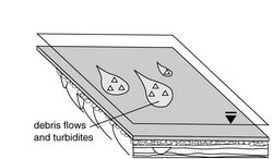
subaqueous siope failure (FA3)
4
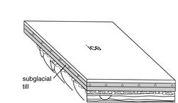
subglacial till deposition (FA4) between 10.95 and 10.8 ka BP (southeastward ice flow)
5
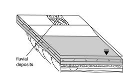
fluvial and shoreface deposition after 10.8 ka BP during post-glacial forced regression
Deglacial depositional model for the Pointe Saint-Nicolas sand pit.
Modèle de sédimentation pendant la déglaciation au Wisconsinien supérieur appliqué aux unités de la sablière de la pointe Saint-Nicolas.
Facies Association 1: Subaqueous Fan
Facies Association 1 makes up the lower half of the outcrop (Fig. 8), and is equivalent to subunits 2 and 3 of LaSalle’s Anse-aux-Hirondelles Formation (see Fig. 3). This facies association, which has a northwest-thinning wedge-like geometry, is interpreted to be an ice-proximal subaqueous fan. The subaqueous fan is composed primarily (~90 %) of normally graded sandy turbidites (Facies 3). The turbidites dip 5-12o towards the northwest, and form the subaqueous fan foresets (Fig. 4). The foresets are cut locally by channels that are filled with sandy hyperconcentrated underflow deposits (Facies 4).
A prominent, flat-based pebble to cobble gravel sheet (Facies 7) caps the subaqueous fan. The upper contact of the gravel sheet is locally convex-up and lobate (Fig. 6h), and is intercalated locally with turbidites with northwest paleoflows (section 8, Fig. 5) and locally with glaciomarine muds (section 1, Fig. 5). The turbidites that are intercalated with the top contact of the gravel sheet are locally dewatered and deformed, and are associated with elutriation pipes in overlying debris flow deposits (Facies 6, Facies Association 3). These data suggest that the gravel sheet is conformable with the overlying 14C-dated deglacial facies associations.
The lower contact of the gravel sheet is flat and erosive. However, several features of the gravel sheet suggest that it is genetically related with the underlying sandy subaqueous fan, and that it was deposited during a sheetflooding event near the end of fan deposition. First, local intercalation of the gravel sheet with overlying turbidites and glaciomarine muds suggests a subaqueous depositional environment akin to that of the underlying sandy fan. Secondly, the gravel sheet was deposited towards the northwest, as were the turbidites located both immediately above and below the gravel sheet (section 8, Fig. 5). Thirdly, the sandy subaqueous fan coarsens-up in the 2 m underlying the gravel sheet (section 8, Fig. 5), suggesting that meltwater discharge increased just prior to gravel deposition. Finally, the flat base of the sheet, sheet-like geometry of the gravel beds and locally convex up nature of the top contact are not compatible with deposition in front of a small efflux, where channelization would be expected (Powell, 1990). In concert, these data are suggestive of sheetflooding from a nearby ice front during final stages of subaqueous fan deposition.
Facies Association 2: Glacial Marine Suspension Deposits
A thick mud bank overlies the subaqueous fan (Fig. 8). The mud bank is composed of stratified (Facies 2) and unstratified (Facies 1) glaciomarine mud with rare pebbles (< 10 %). The lower contact of the mud bank is usually draped overtop of the subaqueous fan (Facies Association 1); locally this contact is intercalated (section 1, Fig. 5). In situ Portlandia arctica shells collected from this facies association ~1 m above the lower contact yielded a 14C age of 10 950 BP (Beta-125967). Muds with similar characteristics, often termed Champlain Sea clays, are found in deglacial successions throughout the St. Lawrence Valley.
Facies Association 3: Subaqueous Gravity Flow Deposits
Facies Association 3 is composed of fossiliferous subaqueous debris flow deposits (Facies 6) and normally graded fossiliferous sandy turbidites (Facies 3). The lower contact of Facies Association 3 is erosive, locally dewatered, and can be highly channelized into the underlying mud bank (section 4, Fig. 5). Locally, the underlying mud bank is completely eroded, and Facies Association 3 debris flow deposits lie directly overtop of the subaqueous fan (Facies Association 1). Channels are filled predominantly with debris flow deposits (Facies 6) with occasional thin (< 10 cm) normally graded sandy turbidite interbeds (Facies 1). Debris flow and turbidite beds can also occur as sheet-like ‘couplets’ that pinch out laterally on the decametre scale. These are interpreted to be slope-failure derived debris flows that developed sandy turbulent tails during downslope translation (Mohrig et al., 1998).
Facies Association 4: Subglacial Till and Associated Glaciotectonized Muds
Facies Association 4 consists primarily of a thin sheet of homogeneous diamicton interpreted to be subglacial till (Facies 5) that runs discontinuously across the entire outcrop (Fig. 8). Also included in this facies association are ductilely deformed glaciomarine muds (Facies Association 2) underlying the subglacial till (see sections 1 and 2, Fig. 5). The lower contact of the till sheet is sharp. Balanus hameri fragments collected by Lasalle and Shilts (1993) from a gray, compact, calcareous diamicton (that is presumably equivalent to Facies Association 4) yielded a 14C age of 11 200 14C BP (GSC-1476).
Depositional Model
A depositional model for the Pointe Saint-Nicolas sand pit is presented in Figure 9. Although some of the events outlined in the model can be extended ~10 km west of the pit (Cummings, 2000), the depositional model should be considered as having only local significance. In order to give context, the sequence of regional events is shown in Figure 10.
Initial deglaciation at the Pointe Saint-Nicolas was accompanied by an energetic northwestward discharge of meltwater that was issued from a grounding line located nearby to the south (Fig. 9). This discharge deposited a subaqueous fan composed of normally graded sandy turbidites, diffusely laminated sandy channel fills, and gravel outwash. The predominance of turbidites in the subaqueous fan suggests that underflowing was facilitated by relatively low density fresh basinal waters and/or very high suspended sediment concentrations. The presence of diffusely laminated sands suggests that meltwater underlows were often hyperconcentrated (20-40 % vol) and highly energetic. Maximum cross-bed thickness observed in the subaqueous fan (~2.5 m) suggests that flow depth may have been ~15 m or more during subaqueous fan deposition (as dunes, unlike ripples, typically scale to the boundary layer at a ratio between 1:6 and 1:10 [Allen, 1985; Leclair and Bridge, 2001]).
Given the current lack of evidence of early marine incursion up the axis of the St. Lawrence Valley west of Québec City (see Parent and Occhietti, 1988), it seems most likely that the subaqueous fan at Pointe Saint-Nicolas was deposited in a subglacial (brackish?) body of water. Establishing a unequivocal relationship between the episode of subaqueous fan deposition at Pointe Saint-Nicolas and an apparent period of early marine incursion east of Québec City (e.g. 12 400 14C BP date at Charlesbourg — GSC-1533) requires additional supporting 14C data. The timing of initial deglaciation at Pointe Saint-Nicolas therefore remains unconstrained, as plant macrofossils from underlying organic-rich silty sand Subunit 1 of the Anse-aux-Hirondelles Formation have previously yielded a date of > 42 000 14C ka BP (GSC-3420).
By 11 200 14C BP (GSC-1476) subaqueous fan deposition at Pointe Saint-Nicolas had ended. An ice-free and glaciomarine Champlain Sea occupied the axis of the valley, and muds were being deposited from suspension (Fig. 9). Iceberg calving during mud deposition is equivocal, as no iceberg homogenization/turbation, iceberg mound-dump, or keel structures (Thomas and Connell, 1984; Powell and Molnia, 1989; Dowdeswell et al., 1994) were observed at Pointe Saint-Nicolas. Striated pebbles and cobbles in glaciomarine mud facies may simply have been rafted by seasonal sea ice (Powell and Molnia, 1989; Cowan et al., 1999). Mud deposition continued until at least 10 950 14C BP (Beta-125967).
Subaqueous failure along the flanks of the basin ensued following the introduction of glaciomarine muds into the basin (Fig. 9). Large channels cut into the top of the glaciomarine mud bank at Pointe Saint-Nicolas are interpreted here as slump scars. Failure of the muddy subaqueous flanks of the Champlain Sea basin at Pointe Saint-Nicolas produced fossiliferous debris flows and turbidites.
Following the advent of slope modification, a grounded Laurentide Ice Sheet readvanced through the Champlain Sea towards the south and deposited the mildly fossiliferous St. Nicolas Till (Fig. 9; LaSalle and Silts, 1993; Cummings, 2000). The muddy texture and fossiliferous nature of the St. Nicolas Till suggests that it was sourced primarily from the underlying Champlain Sea glaciomarine mud. The St. Nicolas readvance (surge?) occurred after 10 950 14C BP (Beta-125967) but prior to ~10 800 14C BP, when the St. Narcisse Moraine was deposited on the north shore (Fig. 10). Deposition of the St. Nicolas Till after 10 800 14C BP is unlikely, as no obvious breaks that could have been caused by a readvance are observed in the St. Narcisse Moraine.
Figure 10

Sequence of deglacial events in the Québec City region.
Séquence des évènements dans la région de Québec, au Wisconsinien supérieur.
During postglacial isostatic rebound and associated forced regression, the emergent flanks of the basin around Pointe Saint-Nicolas were reworked by tidal currents (Cummings, 2000; Occhietti et al., 2001a), and fluvial systems began to incise their valleys. At Pointe Saint-Nicolas, a fluvial system reworked underlying fossiliferous sediments and deposited a crudely stratified gravel sheet (Fig. 9). A large ice wedge cast present along the base of the gravel sheet suggests that the climate was still relatively cold at this time.
Discussion
Previously, the subaqueous fan (FA1), which is equivalent to subunits 2 and 3 of LaSalle’s Anse-aux-Hirondelles Formation (Fig. 3), has been interpreted as a Middle Wisonsinan fluvial floodplain unit (LaSalle, 1984, 1989). This interpretation is largely based on the assumption that the lower subaqueous fan contact, which remains buried below the base of the pit, is conformable with the underlying 14C-dated Subunit 1, which is exposed below pit level at the edge of the St. Lawrence River. Although a subaerial fluvial floodplain depositional environment seems compatible with the insects and plant macrofossils present in Subunit 1 (LaSalle 1989), it is definitely incompatible with the organic-free sandy turbidites (Facies 3) and hyperconcentrated underflow deposits (Facies 4) that make up the foresets of the subaqueous fan (i.e. Subunit 2). As the subaqueous fan is not genetically related to Subunit 1, the subaqueous fan is most likely either separated from Subunit 1 by another unit, or overlies Subunit 1 unconformably. Given the high-energy nature of the facies in the subaqueous fan (e.g. hyperconcentrated underflow deposits), the lower fan contact is hypothesized to be an erosion surface formed during an energetic meltwater discharge that accompanied initial deglaciation.
The presence of a Late Wisconsinan subaqueous fan below Champlain Sea deposits at Pointe Saint-Nicolas suggests that a body of water, possibly subglacial, formed during deglaciation in the axis St. Lawrence Valley while ice remained on the south shore. Although there are no obvious ice front landforms near Pointe Saint-Nicolas (are they buried?), northwest paleoflows in the high-energy subaqueous fan facies suggest that both the grounding line and the meltwater source were located updip to the south. Candidate meltwater sources include Lake Candona, or Lake Chaudière-Etchemin, which was located in the Chaudière-Etchemin Valley (see Occhietti et al., 2001b), or possibly even the Champlain Sea after it invaded the Lake Candona basin. Development of a body of water in the valley axis west of Québec City would have effectively severed the pressure gradient that maintained southward flow in subglacial streams that fed these ice-ponded glacial lakes (see esker data in Warwick area on Fig. 1). This would effectively have allowed the ponded lake water to drain downdip into the valley axis. Although this hypothesis should be considered preliminary until tested by further regional study, it is interesting to note that several major paleohydraulic events occurred during deglaciation in the greater Québec City region (e.g. Lake Candona drainage), and no associated deposits have been discovered.
The re-interpretations presented in this paper, in combination with work both upstream and downstream of Pointe Saint-Nicolas (Clet et al., 1991; Clet and Occhietti, 1996; Clet-Pellerin and Occhietti, 2000), suggest that stratigraphic terminology used in the Québec City region (Fig. 2) should be abandoned in favor of terminology used in the central St. Lawrence Valley. The Anse-aux-Hirondelles Formation is composed of two genetically distinct units: 1) an organic-rich lower unit dated between 28 375 and > 42 000 14C BP (Subunit 1), and 2) the overlying Late Wisconsinan subaqueous fan (subunits 2 and 3). The organic-rich unit can probably be correlated with one of the Late Sangamonian-Wisconsinan units in the central St. Lawrence Valley (St. Pierre Sediments or the base of the St. Maurice Rhythmites). The subaqueous fan, which is located stratigraphically below Champlain Sea muds, is a new deglacial unit related to a local (?) early phase of deglaciation in the St. Lawrence axis. Further regional study is needed to determine the extent of this early deglacial episode.
Conclusions
An ice-proximal subaqueous fan was deposited at Pointe Saint-Nicolas during an energetic Late Wisconsinan meltwater discharge. The presence of a northward built subaqueous fan at Pointe Saint-Nicolas suggests that a relatively fresh and possibly subglacial body of water formed during early deglaciation in the axis of the valley while ice remained on the south shore. By 11 200 14C BP, the basin at Pointe Saint-Nicolas was occupied by the Champlain Sea, and massive to stratified mud was being deposited. Introduction of mud into the basin promoted slope failure and debris flowing on the subaqueous flanks of the basin. Between 10 950 and ~10 800 14C BP, the Laurentide Ice Sheet readvanced (surged?) through the Champlain Sea towards the south and deposited the St. Nicolas Till at Pointe Saint-Nicolas. During the subsequent glacio-isostatically induced forced regression, emergent shorefaces were reworked by shore parallel tidal currents, and the St. Lawrence and its tributaries incised their valleys.
Parties annexes
Acknowledgements
Thanks are extended to Gilbert Prichonnet, Jean Veillette and GpQ editor Pierre J. H. Richard, who provided both constructive and critical comments to the manuscript. Hazen Russell read and helped improve an earlier version of the manuscript. DC would like to thank Bill Arnott, Marie Auclair, K. and C. Cummings, S. Dumas, Micheline Lacroix, Michel Lamothe, Michel Parent, Carl Plante and “les Plouffe”, each of whom contributed directly or indirectly to this paper. Funding for the project was provided by a NSERC grant awarded to S.O.
References
- Allen, J.R.L., 1985. Principles of Physical Sedimentology. Blackburn Press, Caldwell, 272 p.
- Arnott, R.W.C. and Hand, B.M., 1989. Bedforms, primary structures and grain fabric in the presence of suspended sediment rain. Journal of Sedimentary Petrology, 59: 1062-1069.
- Bagnold, R.A., 1954. Experiments on a gravity free dispersion of large solid spheres in a Newtonian fluid under shear. Proceedings of the Royal Society of London, 225A: 49-63.
- Barnett, P.D., Sharpe, D., Russell, H., Brennand, T., Gorrell, G., Kenny, F. and Pugin, A., 1997. On the origin of the Oak Ridges Moraine. Canadian Journal of Earth Sciences, 35: 1152-1167.
- Best, J., 1992. Sedimentology and event timing of a catastrophic volcaniclastic mass flow, Volcan Hudson, Southern Chile. Bulletin of Volcanology, 54: 299-318.
- Beverage, J.P. and Culbertson, J.K., 1964. Hyperconcentrations of suspended sediment. Proceedings of the American Society of Civil Engineers, 90: 117-128.
- Bhiry, N., Dionne, J. C., Clet, M., Occhietti, S. and Rondot, J., 2001. Stratigraphy of the Pleistocene units on land and below the St. Lawrence Estuary, and deglaciation pattern in Charlevoix. 64th Annual Reunion of the North East Friends of the Pleistocene Field Trip Guidebook, Québec City, 124 p.
- Blais, A. and Shilts, W.W., 1989. Surficial geology of Saint-Joseph-de-Beauce map area, Chaudière River valley, Québec. Current Research, Part B, Geological Survey of Canada Paper 89-1B: 137-142.
- Chauvin, L., Martineau, G. and LaSalle, P., 1985. Deglaciation of the Lower St. Lawrence region, Québec, p. 111-123. In H. Borns Jr., P. LaSalle and W. Thompson, ed., Late Pleistocene history of northeastern New England and adjacent Québec. Geological Society of America Special Paper 197, Boulder, 159 p.
- Clet, M. and Occhietti, S., 1996. Palynologie et paléoenvironnements de la sous-séquence des Sédiments de Saint-Pierre, Rythmites du Saint-Maurice et Sables des Vieilles-Forges, Pléistocène supérieur de la vallée du Saint-Laurent, Québec. Géographie physique et Quaternaire, 50: 287-310.
- Clet, M., Occhietti, S. and Richard, P.J.H., 1991. Palynologie et lithostratigraphie du Pléistocène du site de Donnaconna, vallée du Saint-Laurent, Québec. Géographie physique et Quaternaire, 45: 125-140.
- Clet-Pellerin, M. and Occhietti, S., 2000. Pleistocene palynostratigraphy in the St. Lawrence Valley and middle Estuary. Quaternary International, 68-71: 39-57.
- Cowan, E.A. and Powell, R.D., 1991. Ice proximal sediment accumulation rates in a temperate glacial fjord, southeastern Alaska, p. 78-89. In J.B. Anderson and G.M. Ashley, ed., Glacial Marine Sedimentation: Paleoclimatic Significance. Geological Society of America, Boulder, 269 p.
- Cowan, E.A., Seramur, K., Cai, J. and Powell, R., 1999. Cyclic sedimentation produced by fluctuations in meltwater discharge, tides and marine productivity in an Alaskan Fjiord. Sedimentology, 46: 1109-1126.
- Cummings, D., 2000. Sedimentology of deglacial deposits between Pointe Saint-Nicolas and Rivière du Chêne, Québec City area. M.Sc. thesis, Université du Québec à Montréal, 141 p.
- Dowdeswell, J.A., Whittington, R.J. and Marienfeld, P., 1994. The origin of massive diamicton facies by iceberg rafting and scouring, Scoresby Sund, East Greenland. Sedimentology, 41: 21-35.
- Dreimanis, A., 1988. Tills: Their genetic terminology and classification, p. 17-82. In R.P. Goldthwait and C.L. Matsch, ed., Genetic Classification of Glacigenic Deposits. A. A. Balkema, Rotterdam, 294 p.
- Druitt, T., 1995. Settling behaviour of concentrated dispersions and some volcanological applications. Journal of Volcanology and Geothermal Research, 65: 27-39.
- Eyles, N. and Eyles, C., 1992. Glacial depositional systems, p. 73-100. In R.G. Walker and N.P. James, ed., Facies Models: Response to Sea Level Change. Geological Association of Canada, St. John’s, 409 p.
- Fournier, M., 1998. Stratigraphie des dépôts quaternaires et modalités de déglaciation au Wisconsinien supérieur dans le Charlevoix occidental, Québec, M. Sc. Thesis, Université du Québec à Montréal, 147 p.
- Gadd, N., 1971. Pleistocene geology of the central St. Lawrence Lowland, with selected passages from an unpublished manuscipt: The St. Lawrence Lowland, by J.W. Goldthwaite. Geological Survey of Canada, memoir 359, 153 p.
- Globensky, Y., 1987. Géologie des Basses-Terres du Saint-Laurent. Ministère de l’Énergie et des Ressources, Rapport MM85-02 (avec carte #1999), Québec, 63 p.
- Gorrell, G. and Shaw, J., 1991. Deposition in an esker, bead and fan complex, Lanark, Ontario, Canada. Sedimentary Geology, 72: 285-314.
- Hampton, M., 1979. Buoyancy in debris flows. Journal of Sedimentary Petrology, 49: 753-758.
- Hand, B.M., 1997. Inverse grading resulting from coarse sediment transport lag. Journal of Sedimentary Research, 67: 124-129.
- Hillaire-Marcel, C., 1980. Les faunes des mers post-glaciaires du Québec: quelques considérations paléoécologiques. Géographie physique et Quaternaire, 34: 3-59.
- Hiscott, R., Pickering, K., Bouma, A., Hand, B., Kneller, B., Postma, G. and Soh, W., 1997. Basin floor fans in the North Sea: Sequence stratigraphic models vs. sedimentary facies: Discussion. American Association of Petroleum Geologists, 81: 662-665.
- Iverson, N.R., Baker, R.W. and Hooyer, T.S. 1997. A ring shear device for the study of till deformation: Tests on tills with contrasting clay contents. Quaternary Science Reviews, 16: 1057-1066.
- Iverson, R.M., 1997. The physics of debris flows. Review of Geophysics, 35: 245-296.
- Kneller, B. and Branney, M., 1995. Sustained high-density turbidity currents and deposition of thick massive sands. Sedimentology, 42: 607-616.
- Lamothe, M., 1989. A new framework for the Pleistocene stratigraphy of the central St. Lawrence Lowland, southern Québec. Géographie physique et Quaternaire, 42: 119-129.
- LaSalle, P., 1984. Quaternary stratigraphy of Québec: A review, p. 155-171. In R.J. Fulton, ed., Quaternary Stratigraphy of Canada — A Canadian contribution to IGCP Project 24. Geological Survey of Canada Paper 84-10, Ottawa, 210 p.
- ——— 1989. Stratigraphy and glacial history of the Québec City region, p. 27-70. In P. LaSalle, ed., Friends of the Pleistocene, 52th Annual Reunion, Québec City, Guidebook for Field Excursions.
- LaSalle, P. and Elson, J., 1975. Emplacement of the St. Narcisse Moraine as a climatic event in eastern Canada. Quaternary Research, 5: 621-625.
- LaSalle, P. and Shilts, W.W., 1993. Younger Dryas age readvance of Laurentide Ice into the Champlain Sea. Boreas, 22: 25-37.
- LaSalle, P., Martineau, G. and Chauvin, L., 1977. Morphology, stratigraphy and deglaciation in Beauce-Notre-Dame Mountains-Laurentide Park Area. Ministère des Richesses naturelles Open File Report DPV-516, Québec, 74 p.
- Leclair, S.F. and Bridge, J.S., 2001. Quantitative interpretation of sedimentary structures formed by river dunes. Journal of Sedimentary Research, 71: 713-716.
- Lowe, D., 1975. Water escape structures in coarse-grained sediments. Sedimentology, 22: 157-204.
- ——— 1982. Sediment gravity flows II: Depositional models with special reference to the deposits of high-density turbidity currents. Journal of Sedimentary Petrology, 52: 279-297.
- Middleton, G.V., 1970. Experimental studies related to problems of flysch sedimentation, p. 253-272. In J. Lajoie, ed., Flysch Sedimentology in North America. Geological Survey of Canada Special Paper 7, Toronto, 272 p.
- ——— 1993. Sediment deposition from turbidity currents. Annual Review of Earth and Planetary Sciences, 21: 89-114.
- Middleton, G.V. and Southard, J.B., 1984. Mechanics of sediment movement. 2nd ed., SEPM (Society for Sedimentary Geology), Short Course Notes 3, Tulsa, 400 p.
- Mohrig, D., Whipple, K., Hondzo, M., Ellis, C. and Parker, G., 1998. Hydroplaning of subaqueous debris flows. Geological Society of America Bulletin, 110: 387-394.
- Occhietti, S., Balescu, S., Lamothe, M., Clet, M., Cronin, T., Ferland, P. and Pichet, P., 1996. Late stage-5 glacioisostatic sea in the St. Lawrence Valley, Canada and United States. Quaternary Research, 45: 128-137.
- Occhietti, S., Chartier, M., Hillaire-Marcel, C., Cournoyer, M., Cumbaa, S. L. and Harrington, C. R., 2001a. Paléoenvironnements de la Mer de Champlain dans la région de Québec, entre 11 300 et 9750 BP: le site de Saint-Nicolas. Géographie physique et Quaternaire, 55: 24-46.
- Occhietti, S., Parent, M., Shilts, W. W., Dionne, J.-C., Govare, E. and Harmand, D., 2001b. Late Wisconsinan glacial dynamics, deglaciation and marine invasion in southern Québec. p. 245-272. In T. K.Weddle and M.J. Retelle, ed., Deglacial History and Relative Sea-Level Changes, Northern New England and Adjacent Canada. Geological Society of America, Special Paper 351, Boulder, 292 p.
- Paradis, S. and Bolduc, A., 1999. Mouvement glaciaire vers le nord sur le piedmont laurentien dans la région de Québec, Québec. Recherches en cours 1999-D, Commission géologique du Canada, p. 1-7.
- Parent, M. and Occhietti, S., 1988. Late Wisconsinan deglaciation and Champlain Sea invasion in the St. Lawrence Valley, Québec. Géographie physique et Quaternaire, 42: 215-246.
- ——— 1999. Late Wisconsinan deglaciation and glacial lake development in the Appalachians of southeastern Québec. Géographie physique et Quaternaire, 52: 117-135.
- Phillips, A.C., Smith, N.D. and Powell, R.D., 1991. Laminated sediments in prodeltaic deposits, Glacier Bay, Alaska, p. 51-60. In J.B. Anderson and G.M. Ashley, ed., Glacial marine sedimentation: Paleoclimatic significance. Geological Society of America Special Paper 261, Boulder, 232 p.
- Pierson, T. and Scott, K., 1985. Downstream dilution of a lahar: Transition from debris flow to hyperconcentrated streamflow. Water Resources Research, 21: 1511-1524.
- Postma, G., 1986. Classification for sediment gravity flow deposits based on flow conditions during sedimentation. Geology, 14: 291-294.
- Postma, G., Roep, T. and Ruegg, G., 1983. Sandy-gravelly mass-flow deposits in an ice-marginal lake (Saalian, Leuvenumusche Beek Valley, Veluwe, the Netherlands), with emphasis on plug-flow deposits. Sedimentary Geology, 34: 59-82.
- Powell, R., 1990. Glacimarine processes at grounding-line fans and their growth into ice-contact deltas, p. 53-73. In J. Dowdeswell and J. Scourse, ed., Glacimarine Environments. Geological Society of London Special Publication, 53, London, 423 p.
- Powell, R. and Molnia, B., 1989. Glacimarine sedimentary processes, facies and morphology of the south-southeast Alaska shelf and fjiords. Marine Geology, 85: 359-390.
- Pugh, F. and Wilson, K., 1999. Velocity and concentration distributions in sheet flow above plane beds. Journal of Hydraulic Engineering Research, 125: 117-126.
- Raudkivi, A. J., 1963. Study of sediment ripple formation. Journal of the Hydraulics Division (ASCE), 6: 15-33.
- Rodine, J.D. and Johnson, A.M., 1976. The ability of debris, heavily freigthed with coarse clastic materials, to flow on gentle slopes. Sedimentology, 40: 645-666.
- Rodrigues, C. and Vilks, G., 1994. The impact of glacial lake runoff on the Goldthwait and Champlain Seas: The relationship between Glacial Lake Agassiz runoff and the Younger Dryas. Quaternary Science Reviews, 13: 923-944.
- Rust, R., 1977. Mass flow deposits in a Quaternary succession near Ottawa, Canada: Diagnostic criteria for subaqueous outwash. Canadian Journal of Earth Sciences, 14: 175-184.
- Shackleton, N.J. and Opdyke, N.D., 1973. Oxygen isotopes and paleomagnetic stratigraphy of equitorial equatorial Pacific core V28-238: Oxygen isotope temperatures and ice volumes on a 105 and 106 year scale. Quaternary Research, 3: 39-55.
- Shanmugan, G., 1996. High-density turbidity currents: Are they sandy debris flows? Journal of Sedimentary Research, 66: 2-10.
- ——— 1997. The Bouma sequence and the turbidite mind set. Earth Science Reviews, 42: 201-229.
- Smith, G., 1986. Coarse-grained nonmarine volcaniclastic sediment: Terminology and depositional process. Geological Society of America Bulletin, 97: 1-10.
- Sohn, Y.K., 1997. On traction carpet sedimentation. Journal of Sedimentary Research, 67: 502-509.
- ——— 2000. Coarse-grained debris-flow deposits in the Miocene fan deltas, SE Korea: A scaling analysis. Sedimentary Geology, 130: 45-64.
- Stea R., Piper, D.J., Fader, G. and Boyd, R. 1998. Wisconsinan glacial and sea level history of Maritime Canada and the adjacent continental shelf: A correlation of land and sea events. Geological Society of America Bulletin, 110: 821-845.
- Sumer, B., Kozakiewicz, A., Fredsoe, J. and Diegaard, R., 1996. Velocity and concentration profiles in a sheet flow layer of moveable bed. Journal of Hydraulic Engineering (ASCE), 122: 549-559.
- Thomas, G. and Connell, R., 1984. Iceberg drop, dump, and grounding structures from Pleistocene glaciolacustrine sediments, Scotland. Journal of Sedimentary Petrology, 55: 243-249.
- Thomas, R.H., 1977. Calving bay dynamics and ice sheet retreat up the St. Lawrence Valley system. Géographie physique et Quaternaire, 31: 347-356.
- Vallance, J., 2000. Lahars, p. 601-616. In H. Sigurdsson, ed., Encylopedia of Volcanoes. Academic Press, Toronto, 1456 p.
 10.7202/033101ar
Liste des figures
Figure 1
Location of the Pointe Saint-Nicolas pit, major deglacial landforms, and bedrock provinces in the greater Québec City region of the St. Lawrence Valley (from Chauvin et al., 1985; Globensky, 1987; Parent and Occhietti, 1988).
Localisation de la sablière de la pointe Saint-Nicolas, emplacement des principales moraines et limites des provinces géologiques de la région de Québec (d’après Chauvin et al., 1985 ; Globensky, 1987 ; Parent et Occhietti,1988).
Figure 2
Proposed Quaternary stratigraphic frameworks for the Québec City area (modified from LaSalle, 1984, 1989; LaSalle and Shilts, 1993).
Cadre stratigraphique proposé pour la région de Québec (modifié de LaSalle, 1984, 1989 ; LaSalle et Shilts, 1993).
Figure 3
Previous descriptions of the Pointe Saint-Nicolas section (from LaSalle et al., 1977 and LaSalle 1989).
Descriptions antérieures de l’affleurement de la pointe Saint-Nicolas (d’après LaSalle et al.,1977; LaSalle, 1984).
Figure 4
Pointe Saint-Nicolas pit, portion of the south wall. Paleoflows throughout the section are towards the right (northwest).
Vue partielle de la paroi sud de la sablière Saint-Nicolas. Les structures de paléocourants sont orientées vers la droite (nord-ouest).
Figure 5
Sedimentology and facies associations (FAs), Pointe Saint-Nicolas pit. Sédimentologie et associations de faciès (FAs) de la sablière de la pointe Saint-Nicolas.
a
b
c
d
e
f
g
h
Facies – (a) Mud with rare pebbles (Facies 1); (b) Stratified mud and sand (Facies 2); (c) Normally graded sand (Facies 3); .(d) Diffusely laminated sand (Facies 4); (e) Diffusely laminated sand channel fill (Facies 4); (f) Homogeneous diamicton (Facies 5); (g) Heterogeneous diamicton (Facies 6); (h) Matrix-poor gravel (Facies 7).
Faciès – (a) Silt argileux avec quelques cailloux (faciès 1); (b) faciès stratifié de silt argileux et sable (faciès 2); (c) sable à granoclassement normal (faciès 3); (d) sable à stratification fine et diffuse (faciès 4); (e) chenal rempli de sable à stratification fine et diffuse (faciès 4); (f) diamicton homogène (faciès 5); (g) diamicton hétérogène (faciès 6); (h) gravier à matrice faible (faciès 7).
a
b
Clast (a) lithologies and (b) fabrics from various facies. For clast fabrics, the average A/B plane is indicated by the dashed line, with the dot representing the A axis orientation. Each clast fabric stereoplot is an average of the orientation of 50 clasts.
Lithologie (a) et fabriques (b) de différents faciès. Pour les fabriques établies avec 50 fragments, l’orientation moyenne du plan A/B est indiquée par une ligne brisée ; l’orientation moyenne de l’axe A est représentée par un point noir.
Figure 8
Facies associations, Pointe Saint-Nicolas, and proposed correlation with the marine delta 18O isotope curve.
Association de faciès à la pointe Saint-Nicolas et corrélation avec la courbe isotopique marine.
1
subaqueous fan deposition (FA1) during initial deglaciation prior to 11.2 ka BP (northwest-ward paleoflow)
2
glaciomarine mud deposition (FA2) by 11.2 ka BP
3
subaqueous siope failure (FA3)
4
subglacial till deposition (FA4) between 10.95 and 10.8 ka BP (southeastward ice flow)
5
fluvial and shoreface deposition after 10.8 ka BP during post-glacial forced regression
Deglacial depositional model for the Pointe Saint-Nicolas sand pit.
Modèle de sédimentation pendant la déglaciation au Wisconsinien supérieur appliqué aux unités de la sablière de la pointe Saint-Nicolas.
Figure 10
Sequence of deglacial events in the Québec City region.
Séquence des évènements dans la région de Québec, au Wisconsinien supérieur.
Liste des tableaux
Table I
Facies
Table II
Facies associations