
Résumés
Abstract
The Humber River in western Newfoundland flows through a large interior basin, that influenced Late Wisconsinan ice flow from major dispersal centres to the north, in the Long Range Mountains, and to the east in The Topsails. An early southward ice flow from a source to the north covered coastal areas in the western part of the basin. Subsequent regional ice flow was southwestward to northwestward from The Topsails, while south to southwestward flowing ice from the Long Range Mountains occupied the upper Humber River valley. This flow was confluent with ice from The Topsails and moved northwestward toward Bonne Bay. Regional deglaciation began about 13 ka from the inner coast. Ice occupying the Deer Lake valley dammed glacial Lake Howley in the adjacent Grand Lake and Sandy Lake basins to an elevation up to 85 m above present lake levels, which were controlled by drainage through a western outlet feeding into St. George’s Bay. The lake was lowered by exposure of the South Brook valley outlet, and finally drained catastrophically through a spillway at Junction Brook. Marine limit at the coast was 60 m asl. Inland deltas at the head of Deer Lake and fine-grained sediment exposed in the Deer Lake valley show inundation below 45 m present elevation. This produced a narrow embayment extending at least 50 km inland from the modern coast and is named here as ‘Jukes Arm’. Dated marine macrofossils in the Humber Arm and lower Humber River valley, indicate the deltas at the head of Deer Lake formed about 12.5 ka.
Résumé
Dans l’ouest de Terre-Neuve, le fleuve Humber draine un vaste bassin qui a influencé la direction des flux glaciaires, au Wisconsinien supérieur, à partir des principaux centres de dispersion situés au nord et à l’est. Dans l’ouest du bassin, les régions côtières ont d’abord été occupées par des glaces en provenance des monts Long Range, au nord. Par la suite, le flux glaciaire régional en provenance des Topsails, à l’est, s’est dirigé du sud-ouest vers le nord-ouest, tandis que la glace provenant des monts Long Range s’est écoulée vers le sud et le sud-ouest, occupant le secteur amont de la vallée du Humber. Les flux alors raccordés se sont par la suite orientés vers le nord-est, vers Bonne Bay. La déglaciation régionale a commencé il y a 13 000 ans environ, sur la côte. La glace, qui bloquait la vallée du Deer Lake, a créé le Lac glaciaire Howley, dans les bassins actuels des lacs Grand et Sandy, qui a atteint l’altitude de 85 m. À l’ouest, un exutoire assurait le drainage du lac vers St. George’s Bay. Dans la vallée du South Brook, le dégagement d’un exutoire a entraîné l’abaissement du niveau lacustre ; le drainage catastrophique du lac a été provoqué par la rupture d’un seuil au droit de Junction Brook. La limite marine a atteint 60 m sur la côte. Des deltas à la tête du Deer Lake et des sédiments fins dans la vallée témoignent d’une submersion ayant atteint 45 m, ce qui a engendré un bras de mer, appelé Jukes Arm, s’étendant sur plus de 50 km à l’intérieur des terres. Ces deltas se sont formés il y a 12 500 ans, d’après la datation d’organismes marins.
Resumen
El río Humber situado al oeste de Terranova irriga una gran cuenca interior de gran afluencia durante el Winconsiniano tardío. En esta área convergieron el flujo glacial proveniente de las montañas Longe Range al norte y de Topsails al este. Al oeste de la cuenca, la región costera fue inicialmente recubierta por el flujo de hielos provenientes del norte luego por el flujo glacial regional proveniente de Topsails. El flujo de Topsails se dirigió del sudoeste al noroeste, mientras que los hielos provenientes de Long Range se dirigieron hacia el sur y sudoeste ocupando así la parte superior del valle del río Humber. Posteriormente, su confluencia se orientó en dirección noreste hacia Bonne Bay. El deshielo regional se inicio hace aproximadamente 13 000 años en la región costera. Los hielos que ocupaban el valle del lago Deer formaron el lago glacial de Howley en la cuenca adyacente de los lagos Grand y Sandy a una altitud de 85 m sobre el nivel actual, siendo controlado por un afluente secundario que lo drenaba hacia la bahía St. Georges. El nivel del lago disminuyó al ser drenado hacia el valle South Brook y finalmente por un evento catastrófico que provocó la ruptura de un vertedero en Junction Brook. El limite marino en la costa fue de 60 m nmm. Los deltas situados a la cabeza del lago Deer y los sedimentos finos expuestos en el valle dan testimonio de la sumersión de hasta 45 m con respecto a la elevación actual. Ello provocó la formacion de un brazo de mar llamado Jukes Arm que se extendió 50 km. al interior de la costa. La datación de macro fósiles marinos provenientes del la rama del río Hamber y del valle sitúan la formación de dichos deltas hace aproximadamente 12 500 años.
Corps de l’article
Introduction
Investigation and assessment of ice-flow directions in regions affected by several distinct centres of glaciation can be a complex problem in Quaternary studies. Throughout Newfoundland, the hypothesis of multiple glacial ice caps was established through numerous investigations (e.g., Grant, 1974, 1977, 1989a; Brookes, 1982; Catto, 1998a). Assessment of the directions of ice movement necessary to support the hypothesis requires careful examination of all glacigenic depositional and erosional features. Striations, erosional geomorphic forms, and the distribution of glacially transported erratics are particularly important.
This paper describes the glacial and deglacial history of the Humber River basin and examines the role that a large inland basin surrounded by coastal and interior highlands had on the late-glacial and early Holocene glacial history of western Newfoundland. Research involved the recognition and assessment of indicators of ice flow direction; the mapping and description of Quaternary sediment, landforms, and features; and assessment of the dynamics and genesis of Quaternary features (Batterson, 1999, 2003). Precise understanding of the patterns of, and influences on, glacial movement provides data on glacial extent, volumes, and accumulation areas that are required for construction of glaciological or glacio- climatic models.
Location, Physiography and Geology
The Humber River basin is a major feature of the geography of western Newfoundland and covers an area of approximately 4 400 km2. The Upper Humber River drains a broad lowland mostly lying below 100 m asl, and flows into Deer Lake (5 m asl), below which the Lower Humber River flows 15 km before reaching the ocean at Corner Brook. The basin contains large valleys and sub-basins containing Birchy Lake, Deer Lake, Grand Lake, Hinds Lake, Sandy Lake, and Sheffield Lake.
The basin is flanked on all sides by highlands that form The Topsails, the Long Range Mountains, and the coastal mountains (Lewis Hills, Blow-Me-Down Mountains and North Arm Mountain) that compose the Humber arm allochthon (Fig. 1). Highland areas are bedrock dominated, but contain numerous striated bedrock surfaces covered with a thin and discontinuous diamicton. Diamicton thicker than 10 m is rare, and confined to the Humber River above Deer Lake. Glaciofluvial sediment is found within many of the major valleys, and between Sandy Lake and Grand Lake. Glaciolacustrine sediment identified in the Grand Lake valley and between Grand Lake and Deer Lake (Batterson et al., 1993), formed in proglacial Lake Howley (Batterson, 1999). Marine sediment is exposed below 50 m asl in the Deer Lake valley, extending as far north as Reidville, and is up to 100 m thick in the vicinity of Steady Brook (Fig. 2).
The Long Range Mountains are only breached in two locations in western Newfoundland. At the southwestern end of Grand Lake, a flat-bottomed valley up to 1 500 m wide extends westward to Harrys River (Figs. 1 and 2). The Humber River gorge breaches the Long Range Mountains east of Corner Brook. The gorge is a 4 000 m long, 300-700 m wide, sinuous channel connecting the lower Humber River valley to the ocean at Humber Arm. Valley-parallel striations show that glacier ice occupied the gorge. The lower part of the Humber River is aligned along a pre-existing structural weakness (Cawood and van Gool, 1992). Bedrock is Late Proterozoic to Lower Cambrian psammite, overlain by Lower Cambrian carbonate rocks (Williams and Cawood, 1989). Subsurface water movement has occurred through the carbonate rocks during the Quaternary, as shown by the presence of caves containing glacial erratics (Chislett, 1996), and calcite veining indicative of previous open flow conditions (Ian Knight, Department of Mines and Energy, personal communication).
Figure 1
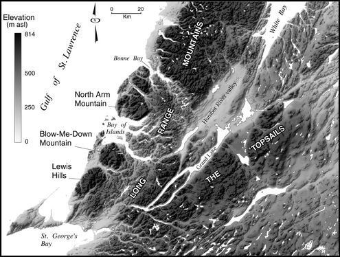
Shaded relief map of the Humber River basin and surrounding area. Refer to Figure 2 for place names.
Carte en relief du bassin du Humber et de la région environnante. Les toponymes apparaissent à la figure 2.
Figure 2

Location of study area, and places mentioned in text.
Localisation de la région à l’étude et toponymes signalés dans le texte.
Rock types that are petrologically and mineralogically distinctive, and that are confined to a discrete source area are particularly useful tools for the determination of distances and directions of glacial transport. The Long Range Mountains are composed of Proterozoic high grade, medium grained pink to grey, quartzo-feldspathic gneiss (Owen and Erdmer, 1986; Williams and Cawood, 1989). Smaller areas of gneiss (medium grained, white to pink biotite-muscovite gneiss) occur in the Hungry Mountain Complex, northeast of Hinds Lake (Whalen and Currie, 1988). Granitoid gneiss and psammitic paragneiss are found in the Caribou Lake complex along the western shore of Grand Lake, south of Northern Harbour (Cawood and van Gool, 1992, 1993), and hybrid gneiss is associated with Ordovician granites north of Sandy Lake. Foliated granite clasts may be confused with gneiss in smaller specimens, and are found in the Hughes Lake complex north of Deer Lake (Williams and Cawood, 1989), and the Glover Group (Whalen and Currie, 1988). Cambrian to Ordovician carbonate rocks and ophiolites associated with the Humber Arm allochthon (Williams and Cawood, 1989) crop out west of Deer Lake. Psammitic and pelitic schists are exposed along the southwestern margin of the Deer Lake valley, and along the north shore of Grand Lake, east to Northern Harbour. Glover Island and the adjacent south side of Grand Lake largely are composed of basalt and tuff of the Glover Group. Silurian volcanic and intrusive rocks (Whalen and Currie, 1988) dominate The Topsails. The central part of the Humber River basin is underlain by red to green Carboniferous flat-lying conglomerate, sandstone, and siltstone (Hyde, 1979).
Ice Flow History
Previous Work
Early descriptions of the physiography of the Humber River basin were provided by Jukes (1842) and Murray (1882). Although influenced by the diluvial theory, Jukes (1842: 337) observed “that fragments of rock, frequently of great size have been removed from their original position in all directions for a few miles”. Murray (1882) suggested that ice from Labrador invaded the island of Newfoundland during the last glacial period, and moved through Humber Arm into Deer Lake; and from St. George’s Bay along Grand Lake. Subsequent work has provided no evidence of glaciation in the Humber River basin from a Labrador source (MacClintock and Twenhofel, 1940; Brookes, 1974). Grant (1989a) concludes that the west coast of Newfoundland was covered by ice from dispersal centres on the Long Range Mountains and in central Newfoundland.
Three investigations of ice flow history in the upper Humber River basin used striation, fabric and clast dispersal data have arrived at three conflicting interpretations. Rogerson (1979) interpreted clast fabrics in till and striation evidence as showing regional northward ice flow through the upper Humber River valley north into White Bay; followed by southwestward flow from Birchy Ridge and the Long Range Mountains funneled along topographic lows into the basin. Vanderveer (1981) used similar evidence to identify a pre-Late Wisconsinan southwestward ice flow, that overtopped parts of the Long Range Mountains and Birchy Ridge, followed by an eastward to southeastward ice flow that covered the northeast part of the basin, and finally by a south to southwestward advance down the upper Humber River valley. Batterson and Taylor (1990) used striation and clast provenance data to show an early west to northwestward Topsails-centred ice flow was followed by a local, southwestward flow confined to the upper Humber River valley.
Methods
Palaeo-ice flow was determined from striations and other erosional features; and depositional evidence including clast fabrics and clast provenance from glacial diamictons (Batterson, 1999). Striations and other micro-erosional forms on bedrock surfaces are common within the Humber River basin. Ice flow direction was assessed from bedrock surface morphology or from oriented micro-erosional features, including wedge striae, nail-head striations, and rat-tail features. Some striations indicated a trend of ice flow movement from which no direction was determined. A strong relationship is evident between striation observations and bedrock type, with finer grained rock types showing striated surfaces more commonly than coarse rock types. Striations on limestone surfaces weather quickly following removal of Quaternary sediment, as in other areas of boreal Newfoundland (Catto, 1998a).
More than one set of striations found on individual rock outcrops were interpreted to reflect changes in the location of glacial dispersal centres, and the influence of subglacial topography on local ice flow directions, rather than representing separate, temporally distinct glacial advances. Surfaces suggesting subaerial weathering between glaciations were not observed in the Humber River basin, although such surfaces were found in the Red Indian Lake area to the east (Klassen and Murton, 1996). Determinations of regional ice flow directions involved analysis of more than 800 observations of striations in the study area (Taylor et al., 1994; Batterson, 1999).
Clast fabrics within basal tills are controlled by ice flow at a particular location and point in time within an ice sheet, and may not reflect regional flow patterns (Catto, 1998b). Well-oriented clast fabrics within orthotills, defined as those having principal eigenvalues (S1) in excess of 0.6, are considered to be indicative of the ice flow direction responsible for orthotill deposition (e.g., Rappol, 1985; Dowdeswell and Sharp, 1986). Of the 173 clast fabrics completed in the Humber River basin on glacigenic diamictons, 119 had S1 values greater than 0.6 (Batterson, 1999).
Clast samples were collected from 351 diamicton exposures, that consisted of at least 50 pebbles and cobbles (2-6 cm), and included a representative sample of all those clasts distinct from the underlying bedrock geology at each site. Exotic clasts commonly represented far less than 1 % of the clast component, but were sampled because of their potential significance to dispersal patterns. A total of 19 723 clasts were identified (Batterson, 1999).
Results and Discussion
A summary of ice flow history for the Humber River basin is presented in Figure 3. It is interpreted as showing that the Humber River basin was covered by ice from dispersal centres located on the Long Range Mountains and The Topsails, and that smaller late-glacial ice centres existed on the highlands surrounding the central basin during deglaciation.
Long Range Mountains Flow
Ice flow from the Long Range Mountains dispersal centre covered the northwest and western part of the Humber River basin (Fig. 3). Several distinct flows were recorded. An early eastward to east-northeastward ice flow toward White Bay was deduced from striations in the upper Humber River valley. These were crosscut by striations produced by a southeast to southward ice flow event that entered the upper Humber River valley and subsequently flowed southwestward along the valley axis (Fig. 3). Ice flowing into the upper Humber River basin was recorded as far east as the Taylor Brook valley. Ice flow was northeastward toward White Bay on the highlands west of White Bay, and southward on the uplands northwest of Adies Pond. Striations are oriented westward in the area southwest of Adies Pond, indicating the increasing influence of Topsails ice toward the southern part of the upper Humber River basin. The pattern of ice flow is also shown by the provenance of clasts found within tills.
Clasts identified as gneiss are found in samples from across the study area (Fig. 4). They are common in the upper Humber River valley, south and west of Adies Pond, on Birchy Ridge, and south of Deer Lake. Gneiss clasts are also found between Deer Lake and Grand Lake, and between Deer Lake and the coast, north of Old Mans Pond. In the upper Humber River valley, the gneiss clasts are found in combination with Carboniferous sandstone-siltstone clasts, rather than clasts from The Topsails, suggesting southwestward transport down the valley. Similarly, the gneiss clasts on Birchy Ridge may be explained by southwestward ice-flow down the Humber River valley, from a source at the north end of the valley. Other sites across the study area contain gneiss clasts that may have been derived from a number of sources. Those found adjacent to Grand Lake are consistent with dispersal from the Hungry Mountain Complex, north of Hinds Lake, due to the presence of foliated gabbro and granite clasts also derived from the complex (Batterson, 1999).
Figure 3
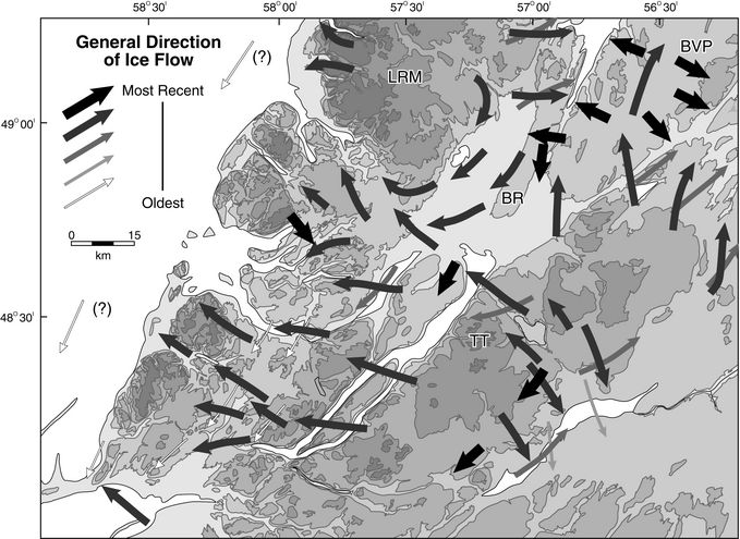
Summary of ice flow in the Humber River basin and surrounding area. The major dispersal centres on the Long Range Mountains (LRM), The Topsails (TT) are indicated. The late deglacial centres on Birchy Ridge (BR) and the Baie Verte Peninsula (BVP) are also shown.
Principales directions glaciaires observées dans le bassin du Humber et la région avoisinante. Les principaux centres de dispersion glaciaire dans les monts Long Range (LRM), les Topsails (TT) sont indiqués. Les centres de déglaciation tardive de Birchy Ridge (BR) et de la péninsule de la Baie Verte (BVP) sont également signalés.
The Topsails Flow
Ice flow across the basin from The Topsails was generally coastward (Fig. 3). At the southwest end of Grand Lake, ice flowed westward to southwestward into the Harrys River valley, crosscutting the earlier striations produced by southward flow (Batterson and Sheppard, 2000). Farther north, ice moved northwest to westward across the Georges Lake valley, as shown by striations that crosscut the earlier southward directed striations. Ice flowed either through the Serpentine Lake valley, or was deflected southward along the eastern margins of the Lewis Hills, and out to the coast through the Fox Island River valley.
Striations and clast provenance data showed that ice flowed westward across the Deer Lake valley (Fig. 3), producing the reddish brown diamictons typical of those mostly derived from Carboniferous sediment in the Deer Lake Basin, e.g., at Bonne Bay (Brookes, 1974). Carboniferous red sandstone-siltstone clasts are found in tills across much of the Humber River basin, and are generally consistent with dispersal from The Topsails ice flow. An exception is red sandstone clasts found south of Corner Brook near Pinchgut Lake and at 640 m asl near the summit of North Arm Mountain. In both cases, regional striation patterns and clast associations within diamictons, are inconsistent with dispersal from The Topsails.
Ice flow from The Topsails deposited coarse, granite-rich diamictons on the highlands east of Glide Lake, the first uplands west of Grand Lake, that would intercept material carried englacially by ice crossing Grand Lake (cf., Batterson, 1989; Liverman, 1992). Exposure of the Topsails Intrusive Suite is confined to the east side of Grand Lake (Whalen and Currie, 1988). Clasts from distinctive bedrock units within it, such as a peralkaline coarse-grained amphibole granite having prominent quartz grains and a distinctive interstitial habit to the mafic minerals (Unit Sp of Whalen and Currie, 1988) (Fig. 5), are found on the highland between the Grand Lake and Deer Lake valleys, and over the limestone bedrock west and southwest of Deer Lake. In the north, Sp clasts are recorded on Birchy Ridge and in the Sandy Lake lowlands to the east. Other granitic rock types from The Topsails, but with less distinctive characteristics, such as white to red, fine- to medium-grained, equigranular granite, and white to pink, medium- to coarse-grained, biotite-amphibole granite showed similar patterns to dispersal of the Sp unit (Batterson, 1999). No Sp clasts were found in the Upper Humber River basin west of Birchy Ridge or over the Long Range Mountains west of Adies Pond.
Figure 4
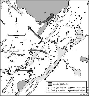
Dispersal of gneiss clasts in glacial diamicton across the Humber River basin.
Dispersion des fragments de gneiss dans le diamicton glaciaire du bassin du Humber.
Figure 5
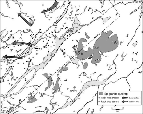
Dispersal of Sp granite (Whalen and Currie, 1988) clasts across the Humber River basin.
Dispersion des fragments de granite de l’unité Sp dans le bassin du Humber (Whalen et Currie, 1988)
Ice crossed Grand Lake, and flowed toward the outer coast through Humber Arm and the major fjords between Humber Arm and Bonne Bay (Old Mans Pond, Goose Arm, Penguin Arm and North Arm). Ice flow was either northwestward toward Bonne Bay or Upper Trout River Pond in the area northwest of Deer Lake, or was drawn southwestward by topography into North Arm (Fig. 3).
Ice flowed northward out of the Sandy Lake basin toward White Bay and onto the southern parts of the Birchy Ridge, as shown by the dispersal of clasts derived from bedrock types restricted to The Topsails, and by striations and oriented landforms (MacClintock and Twenhofel 1940; Grant 1989a). There is no evidence to suggest this ice flow crossed Birchy Ridge into the upper Humber River basin. Farther east, in the Birchy Lake valley, ice flow was northeastward toward the coast.
The exact location of The Topsails dispersal centre is uncertain, and may have migrated during the Late Wisconsinan, similar to other parts of Newfoundland and Labrador (e.g., Klassen and Thompson, 1993; Catto, 1998a). Northwestward ice flow was recorded over the central parts of The Topsails and eastward from Hinds Lake to Buchans (Klassen, 1994). Ice extended down the Hinds Brook valley, and also formed the till ridges exposed in the Goose Pond area (Grant, 1989b), but did not cover the high plateau of The Topsails, that only displays evidence of northeastward flowing ice. In the southwest of The Topsails, ice flow generally was southwestward (Vanderveer and Sparkes, 1982). There is only one striation site recorded in the central part of The Topsails between Hinds Lake and Rainy Lake, since access to this area is limited. Interpolation from adjacent areas suggests northwestward to westward ice flow in this area, thus it appears that a major ice dispersal centre was located on The Topsails, having an ice divide extending along the southwestern margin of the plateau overlooking the Red Indian Lake valley. To the east of the divide, ice flow was into the Red Indian Lake valley or directed northeast along the Exploits River valley (Klassen and Murton, 1996).
Birchy Ridge (200-280 m asl) marks the division between Topsails and Long Range Mountains ice. Relatively low topographic divides influence ice flow from individual ice caps throughout Newfoundland (e.g., Grant, 1974; Catto, 1998a). The northwestern part of Birchy Ridge shows striations from a relatively early eastward flow that may be a southern extension of the eastward flow deduced in the upper Humber River. In the northeast of the ridge, a relatively early southward ice flow is recorded, whereas closer to White Bay striations from an early northward flow are found. Other sites in this area record early south- southwestward and northeastward flow.
Evidence of complex ice flow is not restricted to the higher parts of Birchy Ridge. At the north end of Sandy Lake, adjacent to the eastern margin of Birchy Ridge southward oriented striations crosscut earlier north-northeastward striations. These striations indicate a later flow of ice, possibly from the Long Range Mountains. Less than 1 km to the east, other striations indicate dominantly northward ice flow. Clast provenance of local diamictons shows that ice from The Topsails did not overtop Birchy Ridge, although granite and porphyry clasts from The Topsails are found at the northern and southern ends of the ridge.
Glaciation of Coastal Highlands
The presence of erratics and unweathered striated bedrock surfaces found on the Lewis Hills, Blow-Me-Down Mountain, and North Arm Mountain shows that these areas supported, or were crossed by, glacier ice. On the western Lewis Hills, striations having trends of 060°-240° are present at several sites. Sites in the eastern Lewis Hills have striations oriented at 130°-310°. The striations had no preserved directional indicators and no clasts were found indicating dispersal from The Topsails.
Striations indicating ice flow toward 290° occur near Blow-Me-Down Mountain (elevation 640 m asl), along with peridotite clasts probably derived from a source to the southeast. A granite clast derived from the Topsails Intrusive Suite was collected on the southern part of the Blow-Me-Down massif (D. Taylor, Department of Mines and Energy, personal communication, 1995). Clasts identified as red Carboniferous sandstone and siltstone found on North Arm Mountain indicate glacial transport from the Deer Lake basin. The timing of glaciation of the coastal mountains is unknown, and further research is required. Cosmogenic isotopic analysis (Gosse and Grant, 1993; Gosse, 2001) showed that surfaces previously considered Late Wisconsinan nunataks in Gros Morne National Park were ice-covered during the Late Wisconsinan.
Late-glacial Ice Centres
Several sites were found that showed striation directions at variance with the regional ice flow patterns (Fig. 3). In each case, the latest ice flow event could not be traced over more than 1 km, and appear to be the most recent event. These are interpreted to represent late-stage events from remnant ice centres that developed on highland areas during deglaciation. Each of the sites is downslope of a highland area. (cf., Lagerlund et al., 1995; Catto, 1998a). All late-glacial readvances in the Humber River basin remain undated.
There is limited striation evidence for late-glacial readvances in the Humber River basin. The early northeast flow from The Topsails was followed by a later south-southwestward flow down the Glide Brook/Pynn’s Brook valley toward Deer Lake, and a southward flow east of Glide Brook toward Grand Lake. The source of this late glacial ice is uncertain, although the absence of Carboniferous sandstone clasts precludes flow from the Humber River valley. At the mouth of the Pynn’s Brook valley, four clast fabrics taken from glacial diamictons showed preferred orientations normal to striations showing flow down the valley.
Regional Implications of Ice Flow
Evidence for the earliest recorded ice flow from a source north of the basin was found along the Gulf of St. Lawrence west of the Long Range Mountains, in the Deer Lake valley, in the Georges Lake valley (elevation 280 m asl), and between Humber Arm and Serpentine Lake (elevation 240 m asl) (Figs. 1, 2). Striations oriented south to south-southwest were recorded eastward from the coastline to the north end of Corner Brook Lake. Clast fabrics having a preferred clast orientation trending north to south are present in basal orthotill deposits on the north shore of the Humber Arm and south of Corner Brook. Red Carboniferous clasts found near Pinchgut Lake were transported by southward flowing ice across the Deer Lake basin.
Striations directed to the south along the margin of the Gulf of St. Lawrence have been reported from areas to the north of the Humber Basin (Mihychuk, 1986; Grant, 1994). Early southward-oriented striations also have been noted on the Port au Port Peninsula in southwest Newfoundland (MacClintock and Twenhofel, 1940; Taylor, 1994; Batterson and Sheppard, 2000). Brookes (1970, 1974) attributed these to ice flow across the Lewis Hills.
Southward ice flow could result either from the diversion of Newfoundland- based ice by the extension of the Laurentide ice sheet covering the Gulf of St. Lawrence, or by direct impingement of Laurentide ice on the west coast of Newfoundland. Josenhans and Lehman (1999) recognized till produced by Laurentide ice beneath the Gulf of St. Lawrence. Distinctive erratic clasts from Labrador and the Québec North Shore, however, have not been found in westernmost Newfoundland to the south of St. Barbe. The available data suggests that Laurentide ice in the Gulf of St. Lawrence was confluent with Newfoundland- based glaciers, and acted to deflect them to the south and southwest, but never reached the shoreline of Newfoundland in the Humber Arm or St. George’s Bay areas.
In summary, the pattern of glacial striations and clast dispersal suggests a sequence of early flow from a source in the Long Range Mountains that covered the northern and western margins of the basin, followed by a regional radial flow from a dispersal centre on The Topsails that covered most of the basin apart from the upper Humber River valley and north. Deglaciation produced local, small ice caps on coastal and interior hilltops, with limited evidence for local readvance of ice.
Pro-glacial Lake Development
During deglaciation a large proglacial lake, glacial Lake Howley, occupied a series of interconnected lake basins, including the modern day Grand Lake, Sandy Lake, Deer Lake, and Birchy Lake (Batterson et al., 1993), although existence of the lake has been debated (Batterson et al., 1995; Brookes, 1995). Glacial Lake Howley was argued to have been impounded by ice dams at the two low points on the basin margin, the Humber River gorge at ± 0 m asl and the Birchy Lake valley at ± 110 m asl (Fig. 6). Lake level was controlled by an outlet through the Harrys River channel at the western end of Grand Lake. The proposed lake was more than 125 km long, and up to 25 km wide, having a surface area of about 1850 km2 (Batterson et al., 1993).
Batterson (1997) and Brookes (1997) interpreted sediment exposed at the mouth of Deer Lake as having been deposited as an ice-contact glaciomarine delta, indicating that ice was present when the delta was constructed. Mapping in the upper Humber River area (Batterson and Taylor, 1994; Batterson, 1999) also failed to show the high level deltas and lacustrine sediment required to extend the lake into this area, and an esker near Adies Pond, unmodified by lake activity, shows that ice retreated northward up the valley. These factors required a re-assessment of the lake configuration.
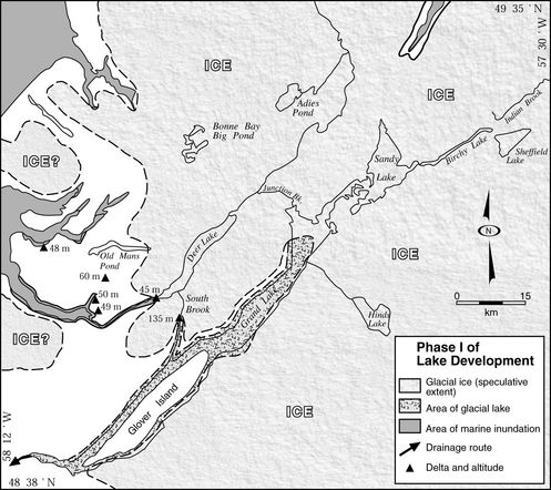
Glacial Lake Howley was likely smaller than proposed by Batterson et al. (1993). The reconstruction presented here (Figs 7a, b, c) describes a long, narrow lake occupying the Grand Lake basin, up to 135 km long and 10 km wide, having a surface area of 650 km2. The Humber River valley above Deer Lake was filled with ice during the glacial Lake Howley phase in Grand Lake (Fig. 7a), and the water surface was controlled by the elevation of the outflow at the western end of the lake into Harrys River. Some of the high level beaches (to 170 m asl) on the west side of the lake may have been cut during this early phase of lake development .
In addition to the Harrys River outflow, the level of glacial Lake Howley was controlled by two outlets. The first, through the South Brook valley, lowered water levels from up to 170 m (based on the elevation of strandlines on the west side of the lake), to 145 m (the level of the outlet at the southern end of South Brook). The areal extent of the early phase of the lake is unclear. A single delta, at Harry’s Brook, has a similar elevation to the high beaches on the west side of Grand Lake. The lake may therefore have been of limited temporal or areal extent. It is possible that this early phase extended into the modern South Brook valley.
Glacial Lake Howley developed rapidly during deglaciation as ice retreated across the Grand Lake basin. It likely was a time-transgressive feature and had a continually changing geometry in response to wasting ice in the Grand Lake-Sandy Lake lowlands. The reconstruction represents the cumulative geomorphic signature of several temporary configurations, rather than a single stable lake.
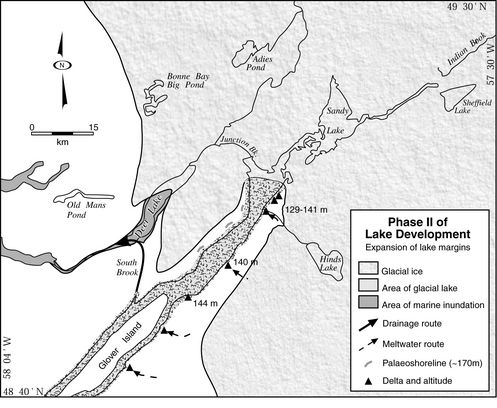
As ice retreated northward up the valley from the delta at Deer Lake, the South Brook valley was exposed, allowing drainage from glacial Lake Howley (Fig. 7b). The lake surface dropped to about 145 m asl, controlled by the elevation of the channel at the southern end of South Brook, and formed the prominent deltas south of Hinds Brook along the east side of Grand Lake at this elevation. The South Brook valley contains fragmentary evidence for standing water. A large flat-topped, steep-sided ice contact delta in the central part of the valley has a surface elevation of 150 m asl, and two small deltas (140 m and 145 m asl) are preserved on the western side of the valley. Further evidence for standing water in the South Brook valley is the presence of a minimum of 2 m of structureless clayey silt exposed in a test pit at 90 m asl.
The elevations of raised deltas on the east side of Grand Lake (Fig. 7b) increase from 128 m asl at Lewaseechjeech Brook at the southwestern end of Grand Lake to about 145 m north of Hinds Brook. This represents an increase of 0.22 m/km toward the northeast. This value does not necessarily represent the gradient of isostatic tilt, because individual deltas are progressively younger toward the northeast. However, the rate is similar to the 0.20 m/km increase between Stephenville and Springdale (Fig. 2), calculated from known palaeo-sea level data (Grant, 1989a; Scott et al., 1991; Forbes et al., 1993).
The next low point farther up-valley is between the Glide Lake highlands and Birchy Ridge, now occupied by the modern outflow of Grand Lake through Junction Brook. This area must have been dammed by ice during initial deglaciation (Fig. 7b). The distribution of meltwater channels on the Glide Lake highlands and the southern part of Birchy Ridge (Batterson, 1999) suggests melting of ice on highlands north and south of Junction Brook. Ice retreat up the valley was rapid, as indicated by the similar elevations of the delta at the mouth of Deer Lake (45 m asl) and those at the head of the lake (40 m asl). As ice retreated across the Junction Brook lowland (Fig. 7c) it allowed drainage of glacial Lake Howley, through a spillway currently occupied by Junction Brook.
Junction Brook flows through a narrow (less than 450 m), steep sided (40 m deep), flat-bottomed channel incised into bedrock that descends steeply about 30 m over 4.3 km. The geomorphology of this channel is identical to those interpreted to have resulted from rapid discharge of ice-dammed proglacial lakes (e.g., Teller and Thorleifsson, 1987; Fisher and Smith, 1994). Junction Brook was formed as ice retreated northward, and its formation accompanied a drop in lake level from 145 m (controlled by the South Brook outlet), to the pre-modern dam level of about 75 m asl, a drop of 70 m (Fig. 7c). Some lake drainage may also have been through the tributary south of Junction Brook, which is also incised in its lower reaches. Application of the Manning equation to the Junction Brook channel suggests that the maximum discharge can be estimated at ~10 000 m3/s, a rate that, if maintained, would allow lake drainage within 29 days. The peak discharge calculated for glacial Lake Howley is comparable to observed discharges on modern glacier dammed lakes (Walder and Costa, 1996).
Figure 6
a
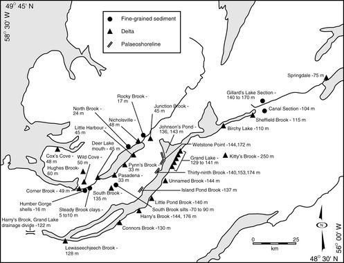
Location map showing features related to higher water level in the Humber River basin. b) The spatial and elevational distribution of features related to higher water levels in the Humber River basin.
Localisation des traits reliés au niveau lacustre élevé dans le bassin du Humber. b) Répartition spatiale et altitudinale des traits reliés aux niveaux lacustres élevés dans le bassin du Humber.
b
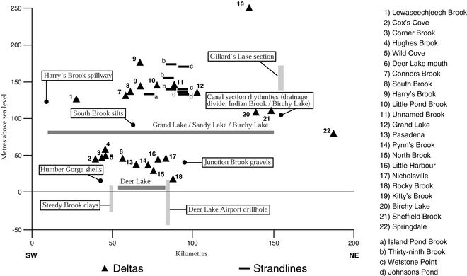
Figure 7
A
Phases of development of glacial Lake Howley, based on the distribution of strandlines and deltas around lake margins.
Phases de développement du Lac glaciaire Howley, reconstituées à partir de la répartition des lignes de rivage et des deltas autour des marges lacustres.
B
C

The available evidence suggests that the Birchy Lake valley contains a contiguous proglacial arm of glacial Lake Howley. Rhythmically bedded silt and clay deposits are present flanking the Indian Brook valley up to 160 m asl. Liverman and St. Croix (1989b) cited the lack of associated deltas or strandline features, and the height of exposures above the valley, in suggesting deposition in an ice-marginal lake in the Birchy Lake valley. The elevation difference between glaciolacustrine sediment at Gillards Lake (Fig. 6) and the eastern shore of Grand Lake might be explained by the same northwestward isostatic tilt evoked for the increase in delta elevation along the east shore of Grand Lake. The presence of rhythmites at 104 m asl, on the watershed between Indian Brook and Birchy Lake, shows the existence of standing water. This is well above the known marine limit for the adjacent coast (Liverman and St. Croix, 1989a, 1989b; Scott et al., 1991). Flat-topped deltas are found at the mouth of Sheffield Brook (115 m asl), and at the southern end of Birchy Lake (105 m asl). An ice dam to the east of Baie Verte Junction impounding the lake at the eastern end allowed the development of these features.
Extensive sand and gravel deposits, initially mapped as ice-contact sediment by Grant (1989b), found along the north shore of Grand Lake (up to about 100 m asl) and along The Main Brook area are evidence for the former connection of the modern Grand Lake and Sandy Lake basins. Palaeo-flow indicators generally support fluvial transport toward Junction Brook. Connection of the Sandy Lake and Birchy Lake basins during regional deglaciation is not as readily apparent.
The lower part of the South Brook valley contains a well-defined terrace sloping upwards toward the south, and containing clasts derived from The Topsails. A channel incised through the ice contact delta at the mouth of Deer Lake is probably the result of lake drainage through the South Brook valley.
Final draining of glacial Lake Howley through the Junction Brook lowlands introduced an estimated 2.6 to 4.5 x 10¹⁰ m3 of water over a period of 30-50 days into an isostatically depressed inner coastal environment, with sea level about 45 m higher than present. Lake drainage formed the Junction Brook spillway. The spillway is the only subaerially-exposed erosional feature, although other erosional features may exist on the floor of modern Deer Lake. The major effect of lake outflow was depositional. The Junction Brook area has a surface veneer of sandy gravel and large (up to 300 cm diameter) granite boulders, deposited as the outflow lost competence to transport them. Fine-grained sediment was likely transported as turbid flows into the Deer Lake basin and the modern lower Humber River valley, forming red beds cored in the Humber Arm (Shaw et al., 2000).
Marine Incursion
Fossiliferous sediment at 43 m asl between two units interpreted as tills was inferred by Coleman (1926) to represent an interglacial deposit near Corner Brook. MacClintock and Twenhofel (1940) considered this deposit, along with the large delta at the mouth of the Humber River at about 46-48 m asl, to be late-glacial. Brookes (1974) established marine limit at about 50 m asl based on the elevation of a raised delta at Corner Brook, and on marine sediment at Cox’s Cove dated at 12 600 ± 170 BP (GSC-868) (Table I). Marine incursion of the lower Humber River and Deer Lake area was described by Batterson et al. (1993). A radiocarbon date on Balanus hameri shells from the Humber River gorge yielded a date of 12 200 ± 90 BP (TO-2885) (Table I), providing a minimum date for deglaciation for the lower reaches of the basin.
Isostatic depression resulted in higher relative sea level during deglaciation than at present. There was a protracted episode of standing water in the Deer Lake basin at elevations up to 50 m asl, resulting in the deposition of deltas along the margins and thick, rhythmically bedded sediment having a sparse microfaunal content in the basin. The paucity of microfauna within these fine-grained sediments indicates that the late-glacial environment in Deer Lake was influenced by inflowing meltwater, producing low salinity and high suspended sediment content. The presence of Balanus hameri shell fragments in the eastern part of the Humber River gorge and a permanently landlocked population of tom cod (Microgadus tomcod) found in Deer Lake (Seabrook, 1962; Scott and Crossman, 1973) confirms that the lower Humber River valley was inundated by the sea. Fluvial flow through the Humber River gorge would preclude recent upstream migration of cod into Deer Lake. The marine incursion is here named ‘Jukes Arm’ (Fig. 8).
The marine limit in the Bay of Islands is defined by raised deltas (Flint, 1940; Brookes, 1974), and dated at ca. 12.6 ka BP, based on marine macro-fauna at Cox’s Cove (Brookes, 1974). The delta at Corner Brook (49 m asl) is an ice-contact feature (Brookes, 1974) that extended on both sides of the valley, and formed at the mouth of the Humber River gorge. It was dissected by meltwater flowing through the Humber River gorge following retreat of ice from the lower Humber River area. The deltas at approximately 45 m asl described from Nicholsville, Junction Brook and elsewhere in the Deer Lake area (Figs. 6, 8) must therefore have formed after those in the Humber Arm. A date of 12 220 ± 90 BP uncal. (TO-2885) from Balanus hameri fossils in the Humber River gorge suggests that the ‘Jukes Arm’ marine invasion of the Deer Lake basin took place shortly after construction of deltas on the coast.
Table I

Radiocarbon dates mentioned in text (location of sites is shown on Fig. 8)
GSC dates have been corrected for fractionation to a base of ∂13C = 0 ‰, whereas isotrace (TO) dates have been corrected to a base of ∂13C = -25 ‰. Isotrace dates also been adjusted to a reservoir effect of 410 years (roughly equivalent to a fractionation correction to a base of ∂13C = 0 ‰).
A relative sea level curve was constructed for the Bay of Islands area, based on radiocarbon dates of marine shells, and published data on lowstand features (Fig. 9, Table I). The curve is poorly constrained, because dates are from shells within marine muds, rather than deltas or littoral sediment. Table I records the highest (and oldest) date as 13 070 ± 90 BP (TO-3624) at 50 m asl from Goose Arm Brook, and the lowest (and youngest) as 10 600 ± 100 BP (GSC-4400) from 6 m asl in Goose Arm. The highest marine feature is the surface of an undated delta in the Hughes Brook valley, at 60 m asl. Shaw and Forbes (1995) identified a sea level lowstand of 6 m below present at Corner Brook. Although this lowstand is not directly dated, interpolation between those dates derived for St. George’s Bay (Forbes et al., 1993; Shaw and Forbes, 1995) and Bonne Bay (Grant, 1972; Brookes and Stevens, 1985) suggests the lowstand occurred about 8 ka BP.
Figure 8

Location of radiocarbon dates, and estimated extent of marine incursion in the Humber River basin.
Localisation des dates au radiocarbone et estimation de l’extension de l’invasion marine dans le bassin du Humber.
Figure 9

Relative sea level curve for the Humber Arm area, based on radiocarbon dates from marine macro-fauna and peat. Data points are shown on Figure 8, and detailed in Table I.
Courbe du niveau marin relatif pour la région du Humber Arm, établie à partir des dates au radiocarbone attribuées à la faune microscopique et à la tourbe. Les localisations apparaissent à la figure 8 et les données pertinentes sont offertes au tableau I.
These data provide a first approximation of a relative sea level curve for the Humber Arm. This Type B curve (cf. Quinlan and Beaumont, 1981, 1982; Liverman, 1994) shows initial emergence and subsequent submergence of the coastline. Relative sea level fall during the latest Wisconsinan and early Holocene was approximately 2.1 m per century, somewhat lower than the rates of 6.1 m to 3.7 m per century established for St. George’s Bay (Bell et al., in press). Relative sea level fell below 0 m asl ca. 10 000 BP.
The relative sea level curve for the Bay of Islands area is in qualitative agreement with that predicted by the maximum ice model of Quinlan and Beaumont (1981, 1982). The timing of the transition from emergence to submergence, and the elevation and date of the marine limit are quantitatively different from Quinlan and Beaumont’s model. Liverman (1994) described similar incompatibilities for Newfoundland as a whole, attributed to the migration of a collapsing ice marginal forebulge.
Summary and Discussion
The entire Humber River basin was glaciated during the Wisconsinan. Topography was an strong control on late-glacial events in the Humber River basin. Ice from the Long Range Mountains drained from Late Wisconsinan ice centres into the upper Humber River valley, and flow from The Topsails was drawn into major fjords that indent the coastline. Initial advance of glaciers was southward from a source to the north. The growing body of evidence from along the western margin of Newfoundland (Mihychuk, 1986; Grant, 1987; Taylor et al., 1994; Liverman et al., 1999; Batterson and Sheppard, 2000; Sheppard et al., 2000) indicates this represented a major flow of Newfoundland ice deflected southward by Laurentide ice farther to the west in the Gulf of St. Lawrence. Ice from the Long Range Mountains occupied the upper Humber River valley during much of the Late Wisconsinan. Later ice flow from The Topsails affected much of the remainder of the basin, but did not cross Birchy Ridge into the upper Humber River valley. Topsails-centred ice appears not to have been topographically controlled as it crossed the Glide Lake highlands and Deer Lake, flowing toward the coast. In the north, ice crossed Sandy Lake and Birchy Lake and flowed toward the coast into White Bay, whereas in the southwest, ice flow was directed toward St. George’s Bay or through Serpentine Lake.
The distribution of eskers, meltwater channels and hummocky moraine indicates that ice retreated across the highlands west of the Humber River valley, and stagnated within the upper Humber River valley, on the Glide Lake highlands, in the lowlands around Howley, and on The Topsails. The radial pattern of meltwater channels also suggests that wasting ice was located on the southern end of Birchy Ridge, on the highlands between the Glide Lake and Deer Lake valleys, overlooking the South Brook valley, and on The Topsails southwest of Hinds Brook. These remnant ice centres remained active, at least for a short period, as indicated by the striation patterns. In the Glide Lake —Pynn’s Brook area, till found overlying glaciofluvial sand-gravel suggests a local readvance down the Pynn’s Brook valley.
The spatial and elevational distribution of features indicating deposition within a body of standing water in the Grand Lake basin, well above marine limit, suggests formation within a single lake, glacial Lake Howley. At its maximum extent, this lake occupied the Grand Lake basin, and parts of modern Sandy Lake and Birchy Lake. Lake level was controlled by drainage to the southwest into Harrys River, and configuration of the lake was controlled by ice retreating through Deer Lake and Sandy Lake. The elevation of shoreline features increases northeastward from 128 m to 150 m asl, due to differential isostatic rebound. Glacial Lake Howley initially partly drained through the South Brook valley, which lowered the proglacial lake level to 145 m asl, the elevation of the col between South Brook and Grand Lake. The lake finally drained through a spillway now occupied by Junction Brook, as ice retreated across the lowland between the Glide Lake highlands and Birchy Ridge. Drainage through the Junction Brook spillway lowered lake level by up to 71 m, representing a volume of 2.6-4.1 x 10¹⁰ m3 of water. Discharge through this channel is estimated at a maximum of 10 200 m3/s. This rate would drain the lake within a 1 to 2 month period.
A marine incursion, here named ‘Jukes Arm’, into the Deer Lake basin at elevations below 50 m asl resulted in the formation of deltas along the basin margins, and deposition of rhythmically bedded sediment within deeper parts of the basin. The presence of a relict population of the marine fish Microgadus tomcod in modern Deer Lake, and the occurrence of Balanus hameri fossils in the Humber River gorge, are evidence of the Jukes Arm marine incursion. Discharge from drainage of glacial Lake Howley would have introduced large quantities of water and sediment into the Deer Lake basin. Coarse-grained material was deposited in the Junction Brook delta, which formed during marine inundation of the Deer Lake basin. Fine-grained sediment was transported through the Deer Lake basin into the lower Humber River valley and subsequently into Humber Arm.
Marine limit on the coast is about 60 m asl, based on the elevation of a delta in the Hughes Brook valley. This is 10 m higher than previously published records of marine limit for the Humber Arm area. Relative sea level fell rapidly from its maximum of 60 m, dated at about 13.1 ka BP, to below modern sea level at about 10.2 ka, and reached a sea level lowstand at - 6 m at about 7.9 ka. Marine muds were likely reworked at this time and resedimented in Humber Arm (Shaw et al., 2000).
Marine deltas at the head of Deer Lake at 45 m asl developed ca. 12.3 to 12.6 ka, and were formed subsequent to lake drainage. Glacial Lake Howley thus briefly existed at some time before these dates. Draining of a lake through the Harry’s River valley before 12.3-12.6 ka is not compatible with the chronology proposed for the St. George’s Bay area by Brookes (1974), which argues that ice occupied the Harry’s River valley at 12.6 ka BP during the Robinsons Head readvance. Batterson and Janes (1997) and Batterson and Sheppard (2000) suggested that this proposed chronostratigraphic sequence is inconsistent with the stratigraphy exposed along the north St. George’s Bay coast. Sheppard et al. (2000) and Bell et al. (2001) interpret the stratigraphy of the St. George’s Bay region as a product of grounding line fan sedimentation in an ice contact glaciomarine environment. Radiocarbon dates from marine shells indicate that northern St. George’s Bay was likely ice free by 13.0 ka.
Parties annexes
Acknowledgements
Field work was conducted with the assistance of a number of individuals, including Spencer Vatcher, David Taylor, Robert Taylor, and Brian McGrath. The manuscript has benefitted from reviews by Dr. Shirley McCuaig and Dr. David Liverman of the Newfoundland Geological Survey, and by Dr. John Shaw of GSC Atlantic, and Dr. Jean-Serge Vincent of the Geological Survey of Canada. Tony Paltanavange completed the figures.
References
- Batterson, M.J., 1989. Quaternary geology and glacial dispersal in the Strange Lake area, Labrador. Newfoundland Department of Mines and Energy, Geological Survey Branch, Report 89-3, 51 p.
- ——— 1997. A revised configuration for glacial Lake Howley, p. 64-65. In K. Storey and G. Davidge, eds., Program and Abstracts. The Canadian Association of Geographers, Annual Meeting, St. John’s, Newfoundland, August 1997, 231 p.
- ——— 1999. Glacial history, sedimentology and palaeo-geography of the Humber River basin, western Newfoundland. Ph.D. thesis, Memorial University of Newfoundland, 540 p.
- ——— 2003. Quaternary geography and sedimentology of the Humber River basin and adjacent areas. Newfoundland Department of Mines and Energy, Geological Survey, Report 03-02, 225 p.
- Batterson, M.J. and Janes, J., 1997. Stratigraphy of Late Quaternary sediments exposed in coastal cliffs west of Stephenville, p. 151-165. In Current Research. Newfoundland Department of Mines and Energy, Geological Survey, Report 97-1, 278 p.
- Batterson, M.J., Liverman, D.G.E. and Kirby, G.E., 1993. Glacial lake development and marine inundation, Deer Lake area, Newfoundland, Canada: Topographically controlled deglaciation of an interior basin. Journal of Quaternary Science, 8: 327-337.
- Batterson, M.J., Liverman, D.G.E. and Kirby, G.E., 1995. Glacial lake development and marine inundation, Deer Lake area, Newfoundland, Canada: Topographically controlled deglaciation of an interior basin – reply. Journal of Quaternary Science, 10: 182-184.
- Batterson, M.J. and Sheppard, K., 2000. Deglacial history of northern St. George’s Bay, western Newfoundland, p. 33-47. In Current Research. Newfoundland Geological Survey, Department of Mines and Energy, Report 2000-1, 348 p.
- Batterson, M.J. and Taylor, D.M., 1990. Glacial history of the Humber River basin, p. 1-6. In Current Research. Newfoundland Department of Mines and Energy, Geological Survey Branch, Report 90-1, 347 p.
- Batterson, M.J. and Taylor, R.C., 1994. Quaternary geology of the upper Humber River area, western Newfoundland, p. 1-9. In Current Research. Newfoundland Department of Mines and Energy, Geological Survey Branch, Report 94-1, 467 p.
- Bell, T., Batterson, M.J. and Liverman, D.G.E., in press. The raised marine record and sea level history of St. George’s Bay, Newfoundland. Canadian Journal of Earth Sciences.
- Bell, T., Liverman, D.G.E., Batterson, M.J., and Sheppard, K., 2001. Late Wisconsinan stratigraphy and chronology of southern St. George’s Bay, Newfoundland: A re-appraisal. Canadian Journal of Earth Sciences, 38: 851-869.
- Blake, W., Jr., 1988. Geological Survey of Canada Radiocarbon Dates XXVII. Geological Survey of Canada, Paper 87-7, 100 p.
- Brookes, I.A., 1970. New evidence for an independent Wisconsinan-age ice cap over Newfoundland. Canadian Journal of Earth Sciences, 7: 1374-1382.
- ——— 1974. Late-Wisconsin glaciation of southwestern Newfoundland (with special reference to the Stephenville map-area). Geological Survey of Canada, Paper 73-40, 31 p.
- ——— 1982. Ice marks in Newfoundland: A history of ideas. Géographie physique et Quaternaire, 36: 139-163.
- ——— 1995. Glacial lake development and marine inundation, Deer Lake area, Newfoundland, Canada: Topographically controlled deglaciation of an interior basin – discussion. Journal of Quaternary Science, 10: 180-182.
- ——— 1997. The short life and early demise of glacial Lake Howley, p. 78-79. In K. Storey and G. Davidge, eds., Program and Abstracts. The Canadian Association of Geographers, Annual Meeting, St. John’s, Newfoundland, August 1997, 231 p.
- Brookes, I.A. and Stevens, R.K., 1985. Radiocarbon age of rock-boring Hiatella arctica (Linné) and postglacial sea-level change at Cowhead, Newfoundland. Canadian Journal of Earth Sciences, 22: 136-140.
- Catto, N.R., 1998a. The pattern of glaciation on the Avalon Peninsula of Newfoundland. Géographie physique et Quaternaire, 52: 23-45.
- ——— 1998b Comparative analysis of striations and diamicton fabrics as ice flow direction indicators, Malpeque Bay region, Prince Edward Island. Boreas, 27: 251-274.
- Cawood, P.A. and van Gool, J.A.M., 1992. Stratigraphic, structural, and metamorphic relations along the eastern margin of the Humber Zone, Corner Brook Lake map area, western Newfoundland, p. 239-247. In Current Research, Part E. Geological Survey of Canada, Paper 92-1E, 401 p.
- ——— 1993. Stratigraphic and structural relations within the western Dunnage Zone, Glover Island region, western Newfoundland., p. 29-37. In Current Research, Part D. Geological Survey of Canada, Paper 93-1D, 213 p.
- Chislett, R.T., 1996. Corner Brook Cave: Corner Brook, Newfoundland: A description and interpretation of the genesis of the cave and the features associated with it. B.Sc. thesis, Memorial University of Newfoundland, St. John’s, Newfoundland, 85 p.
- Coleman, A.P., 1926. The Pleistocene of Newfoundland. Journal of Geology, 34: 193-223.
- Dowdeswell, J.A. and Sharp, M.J., 1986. Characterization of pebble fabrics in modern terrestrial glacigenic sediments. Sedimentology, 33: 699-710.
- Fisher, T.G. and Smith, D.G., 1994. Glacial Lake Agassiz: Its northwest maximum extent and outlet in Saskatchewan (Emerson Phase). Quaternary Science Reviews, 13: 845-858.
- Flint, R.F., 1940. Late Quaternary changes of level in western and southern Newfoundland. Geological Society of America Bulletin, 51: 1757-1780.
- Forbes, D.L., Shaw, J. and Eddy, B.G., 1993. Late Quaternary sedimentation and the postglacial sea-level minimum in Port-Au-Port Bay and vicinity, west Newfoundland. Atlantic Geology, 29: 1-26.
- Gosse, J.C., 2001. Extent of glaciations, p. 11-13. In D.G.E. Liverman, M.J. Batterson and T. Bell, eds., Quaternary Geology of Western Newfoundland. Geological Association of Canada/Mineralogical Association of Canada, Joint Annual Meeting, Field Trip Guide B6, 151 p.
- Gosse, J.C. and Grant, D.R., 1993. Weathering zone cosmogenic radionuclide Quaternary surface exposure age chronology, Gros Morne National Park, Western Newfoundland. Progress Report for Gros Morne National Park, 17 p.
- Grant, D.R., 1972. Postglacial emergence of northern Newfoundland, p. 100-102. In Report of Activities. Geological Survey of Canada, Paper 72-1B, 243 p.
- ——— 1974. Prospecting in Newfoundland and the theory of multiple shrinking ice caps, p. 215-216. In Report of Activities. Geological Survey of Canada, Paper 74-1B, 297 p.
- ——— 1977. Glacial style and ice limits, the Quaternary stratigraphic record, and changes of land and ocean level in the Atlantic Provinces, Canada. Géographie physique et Quaternaire, 31: 247-260.
- ——— 1987. Quaternary geology of Nova Scotia and Newfoundland (including Magdalen Islands). International Union for Quaternary Research, XII INQUA Congress, Ottawa, Excursion Guidebook A-3/C-3. National Research Council of Canada, Publ. 27525, 62 p.
- ——— 1989a. Quaternary geology of the Atlantic Appalachian region of Canada, p. 391-440. In R.J. Fulton, ed., Quaternary Geology of Canada and Greenland. Geological Survey of Canada, Geology of Canada 1, 839 p.
- ——— 1989b. Surficial geology, Sandy Lake-Bay of Islands, Newfoundland. Geological Survey of Canada, map 1664A, scale 1 :250 000.
- ——— 1994. Quaternary geology of Gros Morne National Park area, western Newfoundland, Canada: Glaciation, sea-level change, and mass wasting. Field Trip Guidebook, International Union of Geological Sciences, Commission on Geological Sciences for Environmental Planning, Corner Brook, Newfoundland, July 1994, 14 p.
- Hyde, R.S., 1979. Geology of the Carboniferous strata in portions of the Deer Lake basin, western Newfoundland. Newfoundland Department of Mines and Energy, Mineral Development Division, Report 79-6, 43 p.
- Josenhans, H. and Lehman, S., 1999. Late glacial stratigraphy and history of the Gulf of St. Lawrence, Canada. Canadian Journal of Earth Sciences, 36: 1327-1345.
- Jukes, J.B., 1842. Excursions in and about Newfoundland during the years 1839 and 1840. J. Murray, London, 2 vols, 322 p. and 354 p.
- Klassen, R.A., 1994. A preliminary interpretation of glacial history derived from glacial striations, central Newfoundland, p. 13-22. In Current Research. Geological Survey of Canada, 1994-D, 189 p.
- Klassen, R.A. and Murton, J.B., 1996. Quaternary geology of the Buchans area, Newfoundland: implications for mineral exploration. Canadian Journal of Earth Sciences, 33: 363-377.
- Klassen, R.A. and Thompson, F.J., 1993. Glacial history, drift composition, and mineral exploration, central Labrador. Geological Survey of Canada, Bulletin 435, 76 p.
- Lagerlund, E., Persson, K.M., Krzyszkowski, D., Johansson, P., Dobracka, E., Dobracki, R. and Panzig, W.-A., 1995. Unexpected ice flow directions during the Late Weichselian deglaciation of the South Baltic area indicated by a new lithostratigraphy in NW Poland and NE Germany. Quaternary International, 28: 127-144.
- Liverman, D.G.E., 1992. Application of Regional Quaternary Mapping to Mineral Exploration, Northeastern Newfoundland, Canada. Transactions of the Institution of Mining and Metallurgy, Section B - Applied Earth Science, 101: B89-B98.
- ——— 1994. Relative sea-level history and isostatic rebound in Newfoundland, Canada. Boreas, 23: 217-230.
- Liverman, D.G.E., Sheppard, K. and Taylor, D.M., 1999. Surficial geology of the St. Fintan’s, Little Friars Cove and Flat Bay map areas (NTS 12B/2, 12B/3 and 12B/7), p. 139-148. In Current Research. Newfoundland Department of Mines and Energy, Geological Survey, Report 99-1, 356 p.
- Liverman, D.G.E. and St. Croix, L., 1989a. Ice flow indicators on the Baie Verte Peninsula. Newfoundland Department of Mines and Energy, Open File map 89-36.
- ——— 1989b. Quaternary Geology of the Baie Verte Peninsula, p. 237-247. In Current Research. Newfoundland Department of Mines, Geological Survey of Newfoundland, Report 89-1, 309 p.
- MacClintock, P. and Twenhofel, W.H., 1940. Wisconsin glaciation of Newfoundland. Bulletin of the Geological Society of America, 51: 1729-1756.
- McNeely, R. and McCuaig, S., 1991. Geological Survey of Canada Radiocarbon Dates XXIX. Geological Survey of Canada, Paper 89-7, 134 p.
- Mihychuck, M.A., 1986. Quaternary mapping and exploration in the Bellburns map area (12I/5 and 6) and Trapper prospect areas, p. 271-282. In Current Research. Newfoundland Department of Mines and Energy, Geological Survey Branch, Report 86-1, 324 p.
- Murray, A., 1882. Glaciation in Newfoundland. Proceedings and Transactions of the Royal Society of Canada, 1: 55-76.
- Owen, J.V. and Erdmer, P., 1986. Precambrian and Paleozoic metamorphism in the Long Range Inlier, western Newfoundland., p. 29-38. In Current Research. Geological Survey of Canada, Paper 86-1B, 810 p.
- Quinlan, G. and Beaumont, C., 1981. A comparison of observed and theoretical postglacial relative sea level in Atlantic Canada. Canadian Journal of Earth Sciences, 18: 1146-1163.
- ——— 1982. The deglaciation of Atlantic Canada as reconstructed from the postglacial relative sea level record. Canadian Journal of Earth Sciences, 19: 2232-2246.
- Rappol, M., 1985. Clast-fabric strength in tills and debris flows compared for different environments. Geologie en Mijnbouw, 64: 327-332.
- Rogerson, R.J., 1979. Drift prospecting in the Deer Lake lowlands. Westfield Minerals Limited, Reidville, Newfoundland. Newfoundland Department of Mines and Energy, Unpublished Report, Open File 12H(559), 12 p.
- Scott, S., Catto, N.R. and Liverman, D.G.E., 1991. Sedimentology of Quaternary marine sediments in the Hall’s Bay area, Newfoundland. Atlantic Geology, 27: 181-191.
- Scott, W.B. and Crossman, E.J., 1973. Freshwater fishes of Canada. Department of Fisheries and Oceans, Fisheries Research Board, Bulletin 184, 966 p.
- Seabrook, W.D., 1962. A survey of nine lakes on the Island of Newfoundland. Environment Canada, Fisheries and Marine Services, 70 p.
- Shaw, J., Batterson, M.J., Christian, H. and Courtney, R.C., 2000. A multibeam bathymetric survey of Bay of Islands, Newfoundland: new evidence of late- glacial and Holocene geological processes. Atlantic Geology, 36: 139-155.
- Shaw, J. and Forbes, D.L., 1995. The postglacial relative sea-level lowstand in Newfoundland. Canadian Journal of Earth Sciences, 32: 1308-1330.
- Sheppard, K., Bell, T. and Liverman, D.G.E., 2000. Late Wisconsinan stratigraphy and chronology at Highlands, southern St. George’s Bay, southwest Newfoundland. Quaternary International, 68-71: 275-283.
- Taylor, D.M., 1994. Late Wisconsinan ice-flow patterns in southwestern Newfoundland, p. 47-51. In Current Research. Newfoundland Department of Mines and Energy, Geological Survey Branch, Report 94-1, 467 p.
- Taylor, D.M., St. Croix, L. and Vatcher, S.V., 1994. Newfoundland Striation Database. Newfoundland Department of Mines and Energy, Geological Survey Branch, Open File Nfld 2195.
- Teller, J.T. and Thorleifson, L.H., 1987. Catastrophic flooding into the Great Lakes from Lake Agassiz, p. 121-138. In L. Mayer and D. Nash, eds., Catastrophic Flooding. Allen and Unwin, Boston, 410 p.
- Vanderveer, D.G., 1981. Quaternary mapping - upper Humber River area, p. 192- 194. In Current Research. Newfoundland Department of Mines and Energy, Mineral Development Division, Report 81-1, 199 p.
- Vanderveer, D.G. and Sparkes, B.G., 1982. Regional Quaternary mapping: An aid to mineral exploration in west-central Newfoundland, p. 284-299.In P.H. Davenport, ed., Prospecting in Areas of Glaciated Terrain. Canadian Institute of Mining and Metallurgy, Geology Division, 339 p.
- Walder, J.S. and Costa, J.E., 1996. Outburst floods from glacier-dammed lakes: The effect of mode of lake drainage on flood magnitude. Earth Surface Processes and Landforms, 21: 701-723.
- Whalen, J.B. and Currie, K.L., 1988. Geology, Topsails igneous terrane, Newfoundland. Geological Survey of Canada, Map 1680A, scale 1:200 000.
- Williams, H. and Cawood, P.A., 1989. Geology, Humber Arm Allochthon, Newfoundland. Geological Survey of Canada, Map 1678A. Scale 1:250 000.
 10.7202/032474ar
Liste des figures
Figure 1
Shaded relief map of the Humber River basin and surrounding area. Refer to Figure 2 for place names.
Carte en relief du bassin du Humber et de la région environnante. Les toponymes apparaissent à la figure 2.
Figure 2
Location of study area, and places mentioned in text.
Localisation de la région à l’étude et toponymes signalés dans le texte.
Figure 3
Summary of ice flow in the Humber River basin and surrounding area. The major dispersal centres on the Long Range Mountains (LRM), The Topsails (TT) are indicated. The late deglacial centres on Birchy Ridge (BR) and the Baie Verte Peninsula (BVP) are also shown.
Principales directions glaciaires observées dans le bassin du Humber et la région avoisinante. Les principaux centres de dispersion glaciaire dans les monts Long Range (LRM), les Topsails (TT) sont indiqués. Les centres de déglaciation tardive de Birchy Ridge (BR) et de la péninsule de la Baie Verte (BVP) sont également signalés.
Figure 4
Dispersal of gneiss clasts in glacial diamicton across the Humber River basin.
Dispersion des fragments de gneiss dans le diamicton glaciaire du bassin du Humber.
Figure 5
Dispersal of Sp granite (Whalen and Currie, 1988) clasts across the Humber River basin.
Dispersion des fragments de granite de l’unité Sp dans le bassin du Humber (Whalen et Currie, 1988)
a
Location map showing features related to higher water level in the Humber River basin. b) The spatial and elevational distribution of features related to higher water levels in the Humber River basin.
Localisation des traits reliés au niveau lacustre élevé dans le bassin du Humber. b) Répartition spatiale et altitudinale des traits reliés aux niveaux lacustres élevés dans le bassin du Humber.
b
A
Phases of development of glacial Lake Howley, based on the distribution of strandlines and deltas around lake margins.
Phases de développement du Lac glaciaire Howley, reconstituées à partir de la répartition des lignes de rivage et des deltas autour des marges lacustres.
B
C
Figure 8
Location of radiocarbon dates, and estimated extent of marine incursion in the Humber River basin.
Localisation des dates au radiocarbone et estimation de l’extension de l’invasion marine dans le bassin du Humber.
Figure 9
Relative sea level curve for the Humber Arm area, based on radiocarbon dates from marine macro-fauna and peat. Data points are shown on Figure 8, and detailed in Table I.
Courbe du niveau marin relatif pour la région du Humber Arm, établie à partir des dates au radiocarbone attribuées à la faune microscopique et à la tourbe. Les localisations apparaissent à la figure 8 et les données pertinentes sont offertes au tableau I.
Liste des tableaux
Table I
Radiocarbon dates mentioned in text (location of sites is shown on Fig. 8)
GSC dates have been corrected for fractionation to a base of ∂13C = 0 ‰, whereas isotrace (TO) dates have been corrected to a base of ∂13C = -25 ‰. Isotrace dates also been adjusted to a reservoir effect of 410 years (roughly equivalent to a fractionation correction to a base of ∂13C = 0 ‰).