Abstracts
Abstract
Although French and Basque fishing and whaling crews had been coming to southern Labrador since the early sixteenth century, colonization in a more permanent form would not begin until the late 17th and early 18th centuries. Emerging as an outgrowth of similar colonial efforts along Quebec’s Lower North Shore, colonization of Labrador was driven by Canadian interests and administered by colonial officials in Québec. However, the simple possession of Labrador landscapes was not equivalent to their successful exploitation. Detailed study of one land grant in Red Bay-St. Modet demonstrates how tenuous the possession of lands in Labrador could be, whether challenges came from French rivals or from Inuit raids. This article uses historical, cartographic, and archaeological evidence to discuss how the French established, contested, and used Labrador land concessions, and explores how Inuit reacted to the increasing encroachments of the French.
Résumé
Même si les équipages français et basques de pêche et de chasse à la baleine se rendaient au Labrador méridional depuis le début du XVIe siècle, la colonisation sous une forme plus permanente n’a pas commencé avant la fin du XVIIe et le début du XVIIIe siècles. Faisant figure d’excroissance des efforts coloniaux le long de la Basse-Côte-Nord du Québec, la colonisation du Labrador a été motivée par des intérêts canadiens et régie par les administrateurs coloniaux de Québec. Toutefois, le simple fait de posséder des territoires au Labrador ne signifiait pas la réussite de leur exploitation. L’analyse détaillée d’une concession allant de la baie Rouge (aujourd’hui Red Bay) à Saint-Modet montre à quel point la possession de terres au Labrador était précaire, que les difficultés aient été causées par des concurrents français ou par des attaques d’Inuit. Cet article utilise des données historiques, cartographiques et archéologiques pour discuter des moyens par lesquels les Français ont établi, disputé et utilisé leurs concessions, ainsi que de la manière dont les Inuit ont réagi à la fréquence croissante des intrusions françaises.
Article body
Introduction
At the end of the summer fishing season in 1720, in baie Phélypeau (Brador Bay), the French commandant for the Labrador coast wrote his annual letter describing events on the coast from the past year (Brouague 1720). In his correspondence, François Martel de Brouague included a detailed account of a deadly raid that Inuit had launched on a small settlement of overwinterers in Red Bay (Figure 1) in September 1719 (Crompton 2014). In response, he sent several of his men to document the damage and bury the dead; in their journey north, Brouague’s men found no trace of Inuit. Brouague (1720 in Roy 1923: 372) wrote “they have gone back to their country”—that is to say, their territory. With these words, Brouague implied that his world, the world of southern Labrador, was the pays of the French, and that the pays of Inuit lay somewhere else. What we know of these competing landscapes—and indeed, whether they existed in the form described by Brouague at all—is the issue at hand.
Broadly conceived, landscapes are human creations, generated by people’s interactions (both literal and symbolic) with the physical world around them. People inscribe meanings, centres, and boundaries on the spaces they inhabit and move through; as such, landscapes are culturally and temporally variable (e.g., David and Thomas 2008; Ingold 1993). In the context of colonialism, landscapes become powerful points of intersection between European and Aboriginal peoples in the Americas. In these shared landscapes, different peoples enacted the negotiations, conflicts, and creations of the colonial process (e.g., Hicks et al. 2007). By the 18th century, French-Inuit interactions in Labrador landscapes were unpredictable; they could be variously neutral, amicable, tense, or violent (Crompton 2014; Martijn 1980a; Rankin and Crompton in press; Stopp 2002; Trudel 1978, 1980).
This article focuses on the changing fortunes of a single colonial landscape in Labrador—the 18th-century concession established at Red Bay-St. Modet—and builds on previous work on the history of this concession (Crompton 2014; Niellon 1995; Robitaille 1955; Roy 1928), as well as archaeological work on an 18th-century French occupation at Red Bay completed by James Tuck in the 1980s (Tuck 1987, 1988, 1989, 1990). Ultimately, the history of the Red Bay-St. Modet concession illustrates the seemingly orderly process by which the French attempted to impose their colonial landscapes on southern Labrador from afar, the less than orderly way that colonial processes developed on the ground, and the reaction of Inuit to French colonialization and French notions of landscape.
Eighteenth-century Labrador
Southern Labrador, especially in the Strait of Belle Isle, became an important location for interaction between seasonal fishing and whaling crews, concessionaires and their employees, and Inuit. From the 16th century onwards, French and Basque whaling and fishing crews processed marine resources at shore stations they built in southern Labrador. These were summer occupations only; at the end of the season, crews returned to European markets with their catch (La Morandière 1962; Loewen and Delmas 2012; Trudel 1978, 1980). The first reliable census indicates that an average of about 1,300 fishermen seasonally occupied southern Labrador’s shores in the 18th century (Trudel 1978: Table III). Beginning in the late 17th century, formalized French colonialism in the form of large land concessions began to be established in Labrador. Concessionaires based in Québec received these lands for sealing, hunting, fishing, and trade with Aboriginal peoples (Trudel 1978).
Figure 1
Map of Quebec’s Lower North Shore and Labrador locations mentioned in the text

These parcels of land were logical extensions of seigneurial grants, which were focused on extractive industries and established elsewhere in New France, and an outgrowth of French interests up the St. Lawrence (Lavoie 2010). Trudel (1978) counts 23 separate concessions, although some of these overlapped as boundaries changed. The earliest ones were often awarded for very large portions of the Labrador coastline, which were later reduced in size by colonial authorities (e.g., Niellon 1995: 49, 159). Most of the Labrador land grants, particularly the ones after 1713, were given as concessions rather than as seigneuries, and for a set period (typically 10-20 years). Concessions typically spanned four or five leagues of ocean frontage, and extended four or five leagues inland (e.g., Lavoie 2010; Trudel 1978). They represented the advent of formalized colonization in Labrador, but not permanent French settlement. French colonialism did not bring an increase in family-based, permanent settlement. Rather, most concessions were staffed by contractual post-masters and employees, with the landholding concessionaires only present in the summer, if at all (Crompton 2014; Niellon 2010: 14; Trudel 1978: 489).[1] As a result, seasonal occupation and regional mobility typified French presence in southern Labrador.
Archaeologically, European occupations along Quebec’s Lower North Shore have been the focus of work by Fitzhugh et al. (2011) and Niellon (2010), although much additional work (as summarized in Dubreuil 2007) remains unpublished. Our archaeological understanding of 18th-century French sites found further north on the Strait of Belle Isle is not as well-developed. Tuck (1987, 1988, 1989, 1990) has done the most work, excavating trenches through several 18th-century French contexts in Red Bay, and Hull and Mercer (2006) have also conducted brief survey work at a suspected French site in West St. Modeste. Most of the other work on the historical archaeology of southern Labrador has focused on the 16th-century Basque whaling site at Red Bay, with a corresponding interest in Basque whaling sites on the Gulf of St. Lawrence (e.g., Grenier et al. 2007; Loewen and Delmas 2012; Tuck and Grenier 1989).
Since the publication of the special volume of Études/Inuit/Studies on southern Labrador (Martijn and Clermont 1980), our understanding of the extent and dispersal of Inuit populations in southern Labrador has grown tremendously (e.g., Auger 1993; Dumas and Poirier 1994; Rankin 2014; Rankin et al. 2012; Stopp 2002). Inuit were certainly present in the area by the early 16th century, and their habitation sites are plentiful, particularly in those areas now well-investigated by CURA researchers Lisa Rankin (Sandwich Bay) and Marianne Stopp (St. Michael’s Bay) (e.g., Rankin 2010, 2013, this volume; Rankin et al. 2012; Stopp 2012, this volume; Stopp and Wolfe 2011). On the Strait of Belle Isle, no less than in the rest of southern Labrador, Inuit occupation was sustained. Here, Inuit engaged in direct trade with Europeans, exchanging marine mammal products for European goods. They also searched seasonally abandoned European settlements for useful objects, and by the 18th century had engaged in regular raids on occupied stations and settlements (e.g., La Morandière 1962; Langlois 2000; Niellon 1995; Pope, this volume; Rankin and Crompton in press; Trudel 1978, 1980). Material culture of French manufacture, found at Inuit sites dating from the 16th through the 18th centuries, is a result of French-Inuit interaction in this time period.
History of the Red Bay-St. Modet concession
Broadly speaking, the expansion of French concessionaires into Labrador might appear to be a reasonably orderly process—a roughly northward movement, with land grants increasing in number throughout the 18th century—when examined in aggregate (e.g., Thornton 1977: Figure 6-2; Trudel 1978: Table I). However, a closer look at individual concession histories shows the complexity of their development. Some land grants were long-lived, as the Red Bay-St. Modet concession was, while others were quickly abandoned if they proved to be poor sealing locations, as the Thekapoin concession was (Roy 1940: 105). Other concessions were abandoned if the cost of running them had become too high, or if periods of war forced contractions in outfitting and trade, as with the Baie des Esquimaux (Hamilton Inlet) concession (Miquelon 1979; Plamondon 1977). And, as the Red Bay-St. Modet concession illustrates, the boundaries of land grants could be fluidly interpreted, both by the concession’s owner and by rivals.
In 1713, Pierre Constantin became the first concessionaire in the Red Bay-St. Modet area, and, by 1716, the boundaries of his land grant had been established (Niellon 1995). Stretching for four leagues along the coast around the Rivière des François (also spelled “Français,” now Pinware River) and extending four leagues inland, his grant encompassed the harbours of St. Modet (Pinware Bay) and Red Bay (Crompton 2014; Roy 1940: 29-30). Sometimes, Grand and Petit St. Modet were also specified as distinct places within the concession (Figure 2). Constantin’s concession was challenged on several grounds, with the first challenge coming from Courtemanche, who unsuccessfully tried to prevent Constantin’s establishment on the Labrador coast. By 1716, revised land grants clarified the position of each concession, and were intended to deter any further difficulties between the two men (Niellon 1995). Shortly thereafter, an Inuit attack on Red Bay in 1719 resulted in the destruction of buildings and the deaths of three men. Constantin returned to Red Bay and began rebuilding its infrastructure in 1721 (Constantin 1729; Crompton 2014). He also had to defend his concession from legal threats from afar: in 1727, a priest from St. Malo (Sieur Poiljoly, otherwise known as Prêtre Martin) requested a post in Labrador based at St. Modet (Beauharnois and Hocquart 25 October 1729; Conseil de Marine 13 May 1727). Following several years of discussion between administrators to determine whether the concession was an overlapping claim, Martin’s request was apparently denied (Constantin 1738a).
A much more serious challenge to Constantin’s concession emerged in 1733, when Nicolas-Gaspard Boucault and François Foucault requested a concession based at Grand St. Modet. Constantin protested that this was an overlapping claim and, after years of debate, the matter was eventually decided in Constantin’s favour in 1740 (Robitaille 1955). Despite challenges to his ownership, Constantin maintained a consistent, though not always majority interest in the concession throughout the rest of his life. He occasionally leased his holdings, as he did in 1733 to three men, one of whom was his son-in-law (Niellon 1995: 161). Between 1740 and 1747, he leased portions of his concession to merchants based in Québec, including Louis Bazil, François Havy, and Jean Lefebvre (Miquelon 1974a, 1974b, 1974c). Nevertheless, Constantin remained involved in concession matters, and as late as 1748 intended to send a supply vessel to the region (La Galissonière and Bigot 8 October 1748).
Figure 2
Map of locations around St. Modet and Red Bay

After Constantin’s death in 1751, the Red Bay-St. Modet concession was awarded to Jacques-Michel Bréard, a colonial official and merchant who held the grant until 1753. By this time, the concession had been expanded to include six leagues of coastline frontage, including L’Anse au Diable. Two years later, Bréard returned to France, and the next proprietor was the former Intendant of New France, Gilles Hocquart (Bosher 1979; Roy 1940: 105-107, 113-114). He too would only hold the rights to the concession for a few years, trading it for a post at Grant Mécatina in 1756; the Red Bay-St. Modet concession was then passed on to Jean-Pascal Taché (Roy 1940: 251-252). In 1758, the merchants Havy and Lefebvre took up another interest in the concession, and outfitted a ship to St. Modet for sealing (Amirauté de Québec 1758). In the same year, Inuit again attacked the concession, forcing the overwintering men to flee (Anonymous 1758). The fall of New France in 1763 meant that the governor of Newfoundland became the administrator of the Labrador coast, and that French presence on the coast would be subsequently discouraged. Nevertheless, some French involvement in the area continued on an individual basis (e.g., Whiteley 1969, 1976). By 1774, the Dartmouth firm of Noble and Pinson had a sealing operation at West St. Modeste and a salmon post by the Pinware River (Thornton 1977: 163). In 1775, the London-based merchant William Burgess requested a land grant for the same area. Burgess noted that “the Canada merchants assure [him] that no grant has been made of this territory,” and that the old settlers of the region never made any progress on the land (Burgess 1927[1775]).
The history of the Red Bay-St. Modet region demonstrates several salient points. First, even though concessions might be held long-term, as Constantin did, they might be sublet and administered by different individuals. Concessions might also change hands rapidly, and be held by several different proprietors in the space of a few years. Finally, concession boundaries were not always fixed in space. The Red Bay-St. Modet concession was marked by the inclusion of Red Bay in Constantins time, particularly as he fought to defend the boundaries of his grant against other claimants in the 1720s and 1730s. However, later iterations of the concession grant do not name Red Bay specifically, and we can only guess about its inclusion in the grant in later years. St. Modet, and specifically the Rivière des François, became its geographic focus, and the concession border expanded south in later years.
Disputed landscapes
The Red Bay-St. Modet concession was the target of several legal challenges, the most serious of which came from Boucault and Foucault; resolving these disputes would result in the drafting of petitions, letters, and witness statements, as well as references to cartographic evidence. Extant French maps of the region have been used to explore Inuit presence on the landscape (e.g., Martijn 1980b, Niellon 1995), but they also demonstrate how the French constructed and contested their colonial landscapes on the Labrador coast. Viewed in this manner, maps are more than two-dimensional representations of geographic space; they are also interpretations of space that made arguments about control of the territory they depicted (e.g., Harley 2001). For example, Constantin (1715) drew a map of the Labrador coast, depicting the coastline, islands, and rivers from the Rivière des François to Quessesoikou (Hamilton Inlet) and the approximate location of his habitation. Most importantly, he wrote that the area depicted was 10 leagues away from the concession owned by Courtemanche, to the south in Brador Bay. This was a critical argument for Constantin to make, particularly as he fought to demonstrate that his concession was not prejudicial to Courtemanche’s land to the south.
Unusually, the terms of Constantin’s concession specify his property boundaries as two leagues above and two leagues below “the place known as Constantin’s habitation,” located north of the Rivière des François (Roy 1940: 29). Measuring the boundaries of a concession from a position in the middle was atypical; of all the concessions listed in Roy (1940), Constantin’s was the only one defined in this manner. As a result, the exact location of Constantin’s habitation would become central to the legal challenges to come. In 1733, Foucault and Boucault sent crews to the island of Grand St. Modet for the seal fishery; the two men were soon granted a concession of five leagues in shoreline frontage, measured southwards from the Rivière des François, and encompassing Grand St. Modet (Foucault et al. n.d. [ca. 1734]; Roy 1940: 48-49). Constantin immediately protested, arguing that the grant overlapped with his own. Foucault and Boucault argued that Constantin’s principal habitation lay at Red Bay, and not at St. Modet, making their concession unclaimed land (Foucault et al. 1734-1735). Indeed, they used Constantin’s 1715 map as evidence for their case, arguing that it showed his habitation closer to Red Bay than to St. Modet.
In response, Constantin (1738b: 234v) cited many “preuves” (‘proofs’), including additional cartographic evidence, to argue that his habitation was located about a half league northwest of the Rivière des François. Two maps were drawn up from originals produced by pilot Gabriel Pellegrin, both specifying the location of Constantin’s habitation (Anonymous 1735; Pellegrin 1738). One of the maps, dated 1738 and countersigned by Pellegrin (Figure 3), shows Constantin’s habitation on the headland between St. Modet and Red Bay. This was clearly excerpted from a larger-scale Pellegrin map, which also specified the location of Constantin’s establishment (Pellegrin n.d.). In his correspondence, Constantin (1738b: 236v) especially stressed that the Pellegrin maps were “faites sous les yeux” (‘made under the eyes’) of Richard Testu de La Richardière, a seasoned navigator and port officer charged with hydrographic surveys of the St. Lawrence. La Richardière surveyed the Strait of Belle Isle in 1735, and had actually been to St. Modet and viewed Constantin’s establishment there (Constantin 1738c: 231; Pritchard 1979). Constantin (1738b: 236v-237) emphasized the authorship of the two maps in an attempt to establish their authority as accurate depictions of geographic space. Even though the 1738 map would also appear to support Constantin’s claims, an accompanying anonymous note indicates that it in fact supported Boucault and Foucault’s claim. The note argues that the map shows St. Modet and the Rivière des François as unoccupied, and that Red Bay was the location of Constantin’s actual habitation (Anonymous 1738: 194). The same map was thus used as evidence for both sides of the debate, demonstrating the mutable power of cartographic depiction in French notions of landscape.
The focus on the exact location of Constantin’s habitation meant that the built landscape was also described in letters, petitions, and witness testimony. Witnesses called to testify for Foucault and Boucault recalled little to no evidence of building in St. Modet (though some northeast of the Rivière des François), and much building in Red Bay; those testifying for Constantin described construction in both harbours, with a focus on St. Modet (Hocquart 1734; Robitaille 1955: 164-165). Setting aside the veracity of the recorded evidence, the debate reveals a central facet of French notions of landscape possession: that is, a concession had to be visibly used. If land was not developed in some way, its ownership could be called into question. For colonial administrators, demonstrable development of the land was a key issue, and land not exploited satisfactorily might also be re-distributed to other owners (Belvin 2006: 42). Foucault and Boucault state quite clearly that the unused land in Constantin’s concession had not been properly set up for sealing, and thus was available for anyone to claim. Witnesses on their behalf attributed any visible structures in St. Modet to the work of seasonal fishermen rather than to that of Constantin’s crews (Foucault et al. n.d. [ca. 1734]; Hocquart 1734). Constantin responded with letters and witness testimony detailing the types of structures that he had built in both harbours, and the different places within the overall land grant that were habitually used by his crews (Constantin 1738b; Hocquart 1734).
Figure 3
Detail from a map signed by Pellegrin (1738: 195). Courtesy of Archives nationales d’outre-mer, Aix-en-Provence

Resolution of this dispute took most of the 1730s. Throughout this time, both the Governor and the Intendant of New France supported Foucault and Boucault’s claim to the region. By 1740, the Minister of the Marine in France eventually ruled in favour of Constantin, citing in particular the convincing evidence of Pellegrin’s map (Conseil de Marine 1740: 322). When places were remote from centres of power, maps were instrumental in shaping administrative notions of the French Labrador pays, and used as point and counterpoint in mediating disputes over the area. Appeals to cartographic authority were thus an important way for the French to determine the shape, size, and scale of the Labrador coast that they were interested in: the coastlines, the nearshore islands, and the productive bays, particularly for the seal fishery.
Indeed, many maps of the Labrador coast emphasized what was most valuable for the concessionaire: the location of sealing establishments (e.g., Niellon 1995: Figures 19-23). While concessionaires had rights of fishing, trapping, sealing, and trading with Aboriginal peoples, much of their interest (and indeed, that of colonial administrators) focused on the lucrative seal fishery. Administrators and concessionaires alike expended much paper calculating the profits and the productivity of the seal fishery (e.g., Anonymous 1708, 1744; Hocquart 1745, 1746; Trudel 1980: 487-489). In this regard, it is not surprising that Foucault and Boucault petitioned the authorities for access to Grand St. Modet, which was a good sealing location. One of their arguments was that Constantin already possessed two other sealing locations: one at Red Bay and the other at Petit St. Modet. Boucault and Foucault argued that Constantin was not content with two locations, and was demanding access to a third (Boucault 1739: 26-27). Each location had access to nearshore islands via narrow ocean passages (Figure 2). These were particularly crucial for the French seal fishery, as crews would stretch nets across the narrow passages of water, allowing them to capture and kill groups of migrating seals (Niellon 2010: 13; Trudel 1978: 487). At issue, and a central point of conflict between concessionaires, was the lucrative seal fishery; this would also form a point of contention between French concessionaires and Inuit.
French and Inuit in Red Bay
On balance, Constantin did not seem to possess a single habitation, but instead adopted a dispersed pattern of land-use (Crompton 2014). The positioning of Constantin’s crews on the landscape depended on the season and the activity. Crews might spend summers in St. Modet fishing for cod, and move to Red Bay for the fall seal hunt and overwintering (e.g., Constantin 1738a). Indeed, as an undated map of Red Bay (Figure 4) demonstrates, Constantin’s crews lived in one part of Red Bay, and stayed in another location during the times that the seal fishery was in progress. Such mobility over the landscape necessitated purpose-built structures; little wonder that the description of the built environment recorded in the Constantin-Foucault-Boucault debate varies, with accounts of insubstantial cabanes (‘cabins’), temporary shelters, storehouses, fishery infrastructures, and residences for overwintering (Boucault 1739; Constantin 1738b; Hocquart 1734; Robitaille 1955). Indeed, even the construction of a “manner of fort” in Red Bay was completed by 1719; this was likely not a long-lived structure, for some 10 years later witnesses record that segments of the wooden uprights were missing (Hocquart 1734: 151; Robitaille 1955: 165).
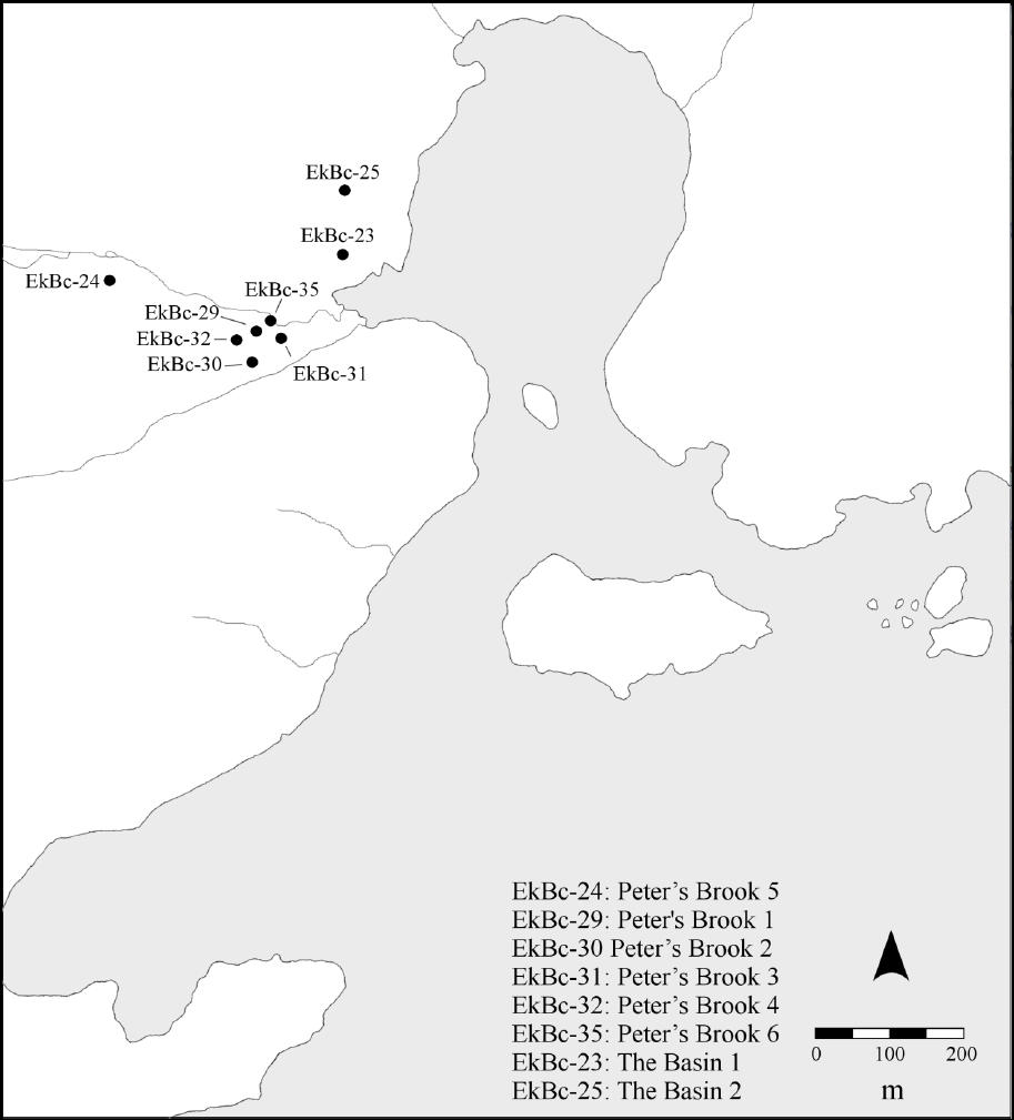
Tuck (1987, 1988, 1989, 1990) studied archaeological contexts in Red Bay related to Constantin’s occupation. Two clusters of sites, at Peter’s Brook and the Basin, were tested, with the sites at Peter’s Brook 1 (EkBc-29), Basin 1 (EkBc-23), and Basin 2 (EkBc-25) being the focus of work (Figure 5). Tuck noted that the Basin 1 and 2 sites were undisturbed, single-occupation sites from the 18th century. Peter’s Brook 1 has an earlier 18th-century occupation, and a later re-occupation (built inside the earlier walls) dating from the late 18th through early 19th centuries. Tuck (1988: 5) suggested that this area was a sheltered location, near sources of fresh water, which would have been well suited to winter living. Certainly, Constantin (1738b) intended his Red Bay crews to be located near sources of water and wood. Indeed, the practice of using sheltered inner bay locations for winter lodgings continued well into the 20th century throughout southern Labrador (Burke 1991; Kelvin and Rankin 2014; Rankin, this volume).
Figure 4
Map of Red Bay. The circled area on the left is labelled “Constantin’s habitation,” and the circled area on the right is labelled “Constantin’s habitation where the seal fishery is carried out” (Anonymous n.d.b). This map, along with another map of St. Modet (Anonymous n.d.a), was also probably used to support the Foucault-Boucault side in their dispute with Constantin (Niellon 1995)

Sites in both the Peter’s Brook and Basin locales had earthen foundations and collapsed chimneys (samples of mortar, presumably from the chimney stacks, were recovered from the Basin locale). This finding corresponds well with descriptions of Constantin’s Red Bay cabanes as pieux-en-terre structures—that is, wooden uprights set into earthen foundations—with brick chimneys (Boucault 1739: 29). Collectively, sites at the Peter’s Brook and Basin locales represent several separate, small structures. Tuck (1988:6) notes that the Basin sites in particular were very small. Testimony from the Constantin-Boucault-Foucault dispute may shed some light on the small size of the sites Tuck encountered. Indeed, one witness noted that he overwintered at St. Modet with three other men in one cabane; by contrast, at Red Bay, they split up and each man built himself a separate small cabane (Hocquart 1734: 151v). Strategies for housing overwintering crews were variable, and thus may have taken shape as one larger dwelling or as several small ones.
Archaeological collections from the Basin sites were re-examined for this article. The Basin 1 site has fragments of two coarse earthenware cook pots, three wine bottles, at least six tobacco pipes, and eight gunflints. The Basin 2 site has fragments from at least four wine bottles, two whetstones (one of which seems to be a repurposed red roof tile), 50 gunflints (some of which were reworked into strike-a-lights), one coarse earthenware vessel, one faience cup, and at least seven tobacco pipes. Both sites (Basin 1: n=136; Basin 2: n=167) produced tiny seed beads, predominantly red, blue, and white. Tuck (1989: 6) suggested that perhaps the Basin sites belonged to Aboriginal servants, being less substantially constructed. The collections included ceramics with drilled holes for mending (a practice commonly performed by Inuit), and fragments from a single clay Aboriginal smoking pipe.
Figure 5
Map of archaeological sites in Red Bay
In the time since Tuck’s initial reporting on the Basin sites, some of these distinctions have become less clear. The more recently uncovered documentary record suggests that insubstantial structures were commonly used by Constantin’s crews. Mended ceramics have also been found at European sites in Labrador (e.g., Burke 1991: 95). The fragments of what is presumed to be an Aboriginal clay tobacco pipe certainly require further study; at the time of writing the pipe remains of unidentified origin, although it has no parallels at contemporary Innu or Inuit sites (Scott Neilsen, pers. comm; Lisa Rankin, pers. comm). Furthermore, much recent work on historic-period Aboriginal occupations in Labrador demonstrates powerful cultural continuities in artifact use, architectural construction, and organizational layout (e.g., Fitzhugh et al. 2011; Rankin 2014; Stopp 2012). By comparison, the Basin sites seem to be a product of European construction and occupation.
The 1719 Inuit attack on Red Bay was a key point in the concession’s history. Constantin lost family members (two of the men killed were his brothers-in-law) and suffered substantial financial losses (Constantin 1722). Refining the date of the Basin sites will help resolve whether they were constructed before or after the raid. Both sites produced tobacco pipe bowl forms typical of the early to mid 18th century. Of these, three “IOHN/STEP/HENS” marked pipe stems can be attributed to John Stephens, a pipe-maker working in Newport on the Isle of Wight. Walker (1971) notes that Stephens was documented as working by 1751, but was likely active for at least 20 years before that time. Apprenticeship rolls from the Isle of Wight indicate that John Bray, alias Stephens, only started to learn the pipe-making trade as an apprentice in August 1719 (Anonymous 1719). It seems most unlikely that stems with the Stephens mark could have appeared at Red Bay sites less than a month after Stephens began his apprenticeship (and it is further unlikely that he would have been permitted to mark pipes with his name while still an apprentice). Accordingly, the Basin sites must postdate the 1719 Inuit raid on Red Bay, and were thus likely part of Constantin’s re-established concession, which he began working on in 1721. The recovery of trade beads from these post-1721 contexts suggests that no matter how much Constantin (1722) might lament the Inuit raid of 1719 as a great betrayal by a traiterous people, the potential for trade with the Inuit in Labrador was too important to completely rule out in subsequent years. Labrador landscapes, though dangerous, were just too profitable.
Furthermore, the 1719 raid reveals the ways in which Inuit and French positioned themselves within Red Bay. The lone French survivor of the attack made it clear that Inuit had been frequently sighted in Red Bay during the month of September. The phrasing suggests that Inuit were not living in Red Bay, but rather were making periodic appearances in the harbour. On the day of the raid, three armed French crewmen went to the water’s edge to trade with Inuit who beckoned them there. The Inuit had other plans; this invitation to trade was a ruse to draw the French men to the waterside and distract them. Other Inuit, hidden in nearby woods emerged and cut off any route of retreat. All three French men were killed with arrow-fire (a surviving fourth man, who had remained behind in a dwelling to keep watch, fled for his life). The raid itself demonstrates that Inuit planned the attack, and understood not only the local landscape but also the ways in which the French habitually used it (Crompton 2014).
Perhaps most revealing was the target of the Inuit: they looted the establishment, taking nets, ropes, and boats, such items being a frequent goal of their raids on fishing stations and concessions in southern Labrador (Trudel 1978). Importantly, they also focused on the facilities used to produce seal oil—taking what they could and destroying the rest. They smashed oil storage vats and burned a storehouse (Constantin 1722, 1729; Crompton 2014). This attack, part of what Pope (this volume) describes as Inuit guerrilla warfare, had the aim of destroying the economic capacity of the concessionaire—and Constantin (1722) estimated his losses to be at least 10,000 livres. Seals—whether for food, oil, or pelts—were valuable commodities for the Inuit, and formed much of their economic livelihood, as well as an important item for trade with Europeans (e.g., Brandy 2013; Rankin 2013). Prime sealing locations, such as those at Red Bay, could prove to be hotly disputed territories in southern Labrador, challenged by Inuit as well as by rival French concessionaires.
Conclusion
Between the 16th and mid-18th centuries, the Strait of Belle Isle was a focal point for trade and interaction between the French and the Inuit. For the French, colonial efforts could be marked by conflict and competing interests between concessionaires. In the case of the Red Bay-St. Modet concession, boundaries were drawn with reference to a cultural construct rather than to geographic referents, the result being years of legal proceedings to establish exactly where the centre (and thus, the borders) of the concession lay. Concessions might change hands frequently; furthermore, concessionaires could and did encroach on each other’s boundaries. Although the disputed borders of the Red Bay-St. Modet concession may be an extreme case, they do illustrate the difficulties associated with establishing, surveying, and administering concessions at a distance from administrative and judicial authority. Landscapes not well understood by administrators could become landscapes with boundaries left open to debate. Challenges from Courtemanche, Prêtre Martin, Foucault, and Boucault took up the first 25 years of Pierre Constantin’s tenure as a concessionaire, although he ultimately persevered through all legal challenges.
The word “habitation” in the singular constantly recurs throughout the documentary record, although this recurrence is an artifact of the phrasing of Constantin’s land grant, in which the word was used as a geographic linchpin. Nevertheless, habitation in the singular, represented by a single, amalgamated occupation, does not seem to have been the case in St. Modet or in Red Bay. Standalone fortified trading posts, such as the one used by the commandant of the Labrador coast, François Martel de Brouague (Beaucours 1708), were not the model for Constantin’s concession, particularly after the “manner of fort” that he constructed at Red Bay fell into disrepair. Land disputes had the unintended benefit of providing testimonials describing how land was used in Constantin’s concession, and it is clear that, in the long term, he took a dispersed approach to occupation within his concession boundaries. Multiple small structures, and not necessarily one centralized structure, were the norm—and this strategy allowed his crews to exploit different locations across the landscape. Land had to be used to demonstrate ownership.
When Brouague wrote in 1720 that the Inuit had returned to their country, he implied that the Inuit lived outside French regions. For the French, their pays was, in practice, focused on narrow slices of land bordering southern Labrador’s coastlines, its islands, and its islets. No matter how much the legal documents formally described concessions in terms of inland dimensions, the actual focus was profoundly coastal. From the French perspective, the Inuit lived outside this narrow coastal horizon, just beyond the French gaze. Boundaries, however, are not often discrete, nor are they necessarily recognized by all parties in an area (Lightfoot and Martinez 1995). For the Inuit, the Strait of Belle Isle was part of their country, where they felt free to trade with the French, to search their abandoned sites for useful items, or to attack their settlements. The 1719 raid on Red Bay shows that the Inuit not only understood how French landscapes were built and used but also how to use this information to their own advantage.
The Red Bay-St. Modet concession also illustrates the importance of sealing locations both for the French and for the Inuit. Constantin’s rivals complained that he possessed two good sealing locations within his concession and that he surely would not need a third—a complaint testifying to the profits that seal oil and pelts might bring on the market. The value of good sealing locations cannot, however, be measured only by the monetary values found in account books. Such locations were also valuable resources for the Inuit. The Red Bay raid, planned to obtain useful objects and to destroy whatever they left behind, must be read as an intentional Inuit demonstration that the French and their sealing operations were not always welcome in Labrador. Further research on 18th-century Inuit habitation sites on the Strait of Belle Isle will further clarify how the French and the Inuit positioned themselves in relation to each other in this region. What remains clear is that in the Strait of Belle Isle, during the 18th century, southern Labrador was a contested region in which neither French nor Inuit exercised complete control.
Appendices
Acknowledgments
I would like to thank the researchers with the “Understanding the Past to Build the Future” SSHRC (Social Sciences and Humanities Research Council of Canada)-CURA project who fostered my interest in French Labrador during my time as project co-ordinator. This article is a direct result of their encouragement and their support. I would also like to thank the anonymous reviewers and Murielle Nagy, whose comments on an earlier draft of this article greatly improved it.
Note
-
[1]
The commandant, or overall administrator in charge of the Labrador coast (first Augustin Le Gardeur Courtemanche, then his stepson, François Martel de Brouague) were unusual, in that they brought their families to Labrador. For example, the three surviving Courtemanche daughters were living in Labrador in 1720, and both Courtemanche and his wife Marie-Charlotte Charest died in Labrador (Roy 1923: 356-357).
Archival sources
- ANOM, Col. B: Archives nationales d’outre-mer, Aix-en-Provence, France. Fonds ministériels, premier empire colonial Série B (Correspondance au départ), online via the Library and Archives Canada website, Series MG1-B.
- ANOM, Col. C11A: Archives nationales d’outre-mer, Aix-en-Provence, France. Fonds ministériels, premier empire colonial Série C11A (Correspondance à l’arrivée, Canada et colonies du nord de l’Amérique, Canada), online via the Library and Archives Canada website, Series MG1-C11A.
- ANOM, Col. C11E: Archives nationales d’outre-mer, Aix-en-Provence, France. Fonds ministériels, premier empire colonial Série C11E (Correspondance générale, des limites et des postes), online via the Library and Archives Canada website, Series MG1-C11E.
- ANOM, Col. E: Archives nationales d’outre-mer, Aix-en-Provence, France. Fonds ministériels, premier empire colonial Série E (Personnel colonial ancien), online via the Library and Archives Canada website, Series MG1-E.
- ANQ, Cote E1, S1: Archives nationales du Québec, Quebec City. Cote E1 (Fonds Intendants), S1 (Ordonnances), online via the ANQ.
- ANQ, Cote TL5: Archives nationales du Québec, Quebec City. Cote TL5 (Collection pièces judiciaires et notariales), online via the ANQ.
- BNF, DCP: Bibliothèque nationale de France, Département des cartes et plans, Paris, online via the BNF.
- IWRO, NBC/3: Isle of Wight Record Office, Newport, Newport Borough Apprenticeship Indentures, online via the UK National Archives website.
- MD, SHD: Ministère de la Défense, Service historique de la Défense, Vincennes.
- AMIRAUTÉ DE QUÉBEC, 1758 Requête de Havy et Lefebvre, négociants à Québec, à l’effet qu’il aurait fait certains paiements et avancées de fournitures aux membres de l’équipage de la goélette “L’Espérance”, commandée par Denis Larchevêque (Larchevesque), capitaine, pour aller au poste Saint-Maudet, October 28, 1758, ANQ, TL5, dossier 4129.
- ANONYMOUS, n.d.a Baye des François et Ance à Loup sur la Côte de Labrador, MD, SHD, cote 6 M 7.B74.
- ANONYMOUS, n.d.b Baye Rouge et Ance aux Esquimaux sur la côte de Labrador, MD, SHD, cote 6 M 7.B74.
- ANONYMOUS, 1708 Notes sur ce que produit le poste de Gros Mécatina, ANOM, Col. C11A, volume 29, fol. 380.
- ANONYMOUS, 1719 Apprentice: John Bray alias Stephens of Newport; Master: Elizabeth Stephens of Gosport, widow; To learn the trade of tobacco pipemaker, August 3, 1719, IWRO, NBC/3, 103.
- ANONYMOUS, 1735 Plan de la concession de Pierre Constantin tiré sur la carte qu’a dressée le pilote Gabriel Pellegrin qui accompagnait Richard Testu de La Richardière lors de son récent voyage au détroit de Belle-Isle, ANOM, Col. C11A, volume 109, fol. 139.
- ANONYMOUS, 1738 Note concernant le “poste à Constantin” qui figure sur le plan, ANOM, Col. C11A, volume 109, fol. 194.
- ANONYMOUS, 1744 État des huiles de loup-marin et de marsouin provenant des postes du bas du fleuve Saint-Laurent pendant l’année 1744, ANOM, Col. C11E, volume 11, fol. 101.
- ANONYMOUS, 1758 Mémoire pour montrer la nécessité aux Malouins, Normands et autres Français qui pêchent dans le détroit de Belle-Isle de trafiquer des armes et des munitions avec les Esquimaux, ANOM, Col. C11A, volume 103, fol. 462.
- BEAUCOURS, Josué Boisberthelot de, 1708 Plan et élévation du fort Pontchartrain à la coste du Labrador, ANOM, 03DFC555C.
- BEAUHARNOIS, Charles de la Boische, Marquis de and Gilles HOCQUART, 1729 Lettre de Beauharnois et Hocquart au ministre, October 25, 1729, ANOM, Col. C11A, volume 51, fol. 29-31.
- BOUCAULT, Nicolas-Gaspard, 1739 Lettre de Boucault, October 22, 1739, ANOM, Col. E, volume 43, dossier “Boucault”: 25-30.
- BROUAGUE, François Martel de, 1720 Lettre de François Martel de Brouague au Conseil de Marine concernant ce qui s’est passé au Labrador depuis août 1719, August 27, 1720, ANOM, Col. C11A, volume 109, fol. 75-91 (transcribed in Roy 1923: 368-374).
- CONSEIL DE MARINE, 1727 Le Conseil de marine à MM. de Beauharnois et Dupuy, May 13 1727, ANOM, Col. B, volume 50, fol. 526.
- CONSEIL DE MARINE, 1740 Le président du conseil de marine à MM. de Beauharnois et Hocquart, April 13, 1740, ANOM, Col. B, volume 70, fol. 322-322v (otherwise paginated as fol. 13-13v).
- CONSTANTIN, Pierre, 1715 Nouvelle découverte depuis la rivière des françois qui est à dix lieües au dessous de Monsieur de Courtemanche du Costé du Nord et jusqu’à chechasosquismat et Quessesoikou, faite par Pierre Constantin en l’année 1715, BNF, DCP, GESH18PF124DIV3P1D, Portefeuille 124, Division 3, Fonds du Service hydrographique de la Marine consacré au Labrador.
- CONSTANTIN, Pierre, 1722 Lettre de Pierre Constantin concernant son entreprise de pêche de la morue et de chasse au loup marin au Labrador, September 18, 1722, ANOM, Col. C11A, volume 122, fol. 144-145v.
- CONSTANTIN, Pierre, 1729 Placet de Constantin à Maurepas, ANOM, Col. C11A, volume 51, fol. 33.
- CONSTANTIN, Pierre, 1738a Réponse de Pierre Constantin à la requête des sieurs François Foucault et Nicolas-Gaspard Boucault, ANOM, Col. C11A, volume 109, fol. 221-228v.
- CONSTANTIN, Pierre, 1738b “Preuves” présentées à Beauharnois et Hocquart par Pierre Constantin, ANOM, Col. C11A, volume 109, fol. 233-237v.
- CONSTANTIN, Pierre, 1738c “Suppliques présentées” à Beauharnois et Hocquart par Pierre Constantin, ANOM, Col. C11A, volume 109, fol. 229-232v.
- FOUCAULT, François, Nicolas-Gaspard BOUCAULT and Martin CHÉRON, n.d.[ca. 1734] Requête adressée à Beauharnois et Hocquart par François Foucault, Nicolas-Gaspard Boucault et Martin (Charles) Chéron, ANOM, Col. C11A, volume 109, fol. 185-186.
- FOUCAULT, François, Nicolas-Gaspard BOUCAULT and Martin CHÉRON, 1734-1735 Requête adressée à l’intendant Hocquart par François Foucault, Nicolas-Gaspard Boucault et Martin Chéron, ANOM, Col. C11A, volume 109, fol. 191-192.
- HOCQUART, Gilles, 1734 Procès-verbal des déclarations des quatre témoins qui comparaissent devant l’intendant Hocquart pour apporter des éclaircissements sur l’étendue de la concession de Pierre Constantin au Labrador; signé par Hocquart, December 7, 1734, ANOM, Col. C11A, volume 109, fol. 150-153.
- HOCQUART, Gilles, 1745 État des huiles de loup marin provenant des postes du bas du fleuve Saint-Laurent pendant l’année 1745, October 8, 1745, ANOM, Col. C11A, volume 83, fol. 261.
- HOCQUART, Gilles, 1746 Extrait du produit des huiles de loup marin dans les postes du bas du fleuve en 1746, September 18, 1746, ANOM, Col. C11A, volume 85, fol. 316-317.
- LA GALISONNIÈRE, Roland-Michel Barrin de and François BIGOT, 1748 Ordonnance du gouverneur de La Galissonière et de l’intendant Bigot, October 8, 1748, ANQ, cote E1, S1, pièce 3837.
- PELLEGRIN, Gabriel, 1738 Extrait de plan tiré de la carte que j’ai faite sur les lieux au Labrador (signé Gabriel Pellegrin), January 30, 1738, ANOM, Col. C11A, volume 109, fol. 195.
- PELLEGRIN, Gabriel, n.d. Carte du détroit de Belle Isle, BNF, DCP, GE SH 18 PF 125 DIV 2 P 6 D.
Acronyms
References
- AUGER, Réginald, 1993 Late-18th and Early-19th-Century Inuit and Europeans in Southern Labrador, Arctic 46(1): 27-34.
- BELVIN, Cleophas, 2006 The Forgotten Labrador: Kegashka to Blanc Sablon, Montreal, McGill-Queen’s University Press.
- BOSHER, J.F., 1979 Bréard, Jacques-Michel, in Dictionary of Canadian Biography, vol. 4, University of Toronto/Université Laval (online at: http://www.biographi.ca/en/bio/breard_jacques_michel_4E.html).
- BURKE, Charles A., 1991 Nineteenth century ceramic artifacts from a seasonally occupied fishing station on Saddle Island, Red Bay, Labrador, Master’s thesis, Memorial University of Newfoundland, St. John’s.
- BRANDY, Eliza, 2013 Inuit Animal Use and the Impact of European Settlement and Trade in Snooks Cove, Labrador, in Peter E. Pope with Shannon Lewis-Simpson (eds), Exploring Atlantic Transitions. Archaeologies of Transience and Permanence in New Found Lands, Woodbridge, The Boydell Press, Society for Post-Medieval Archaeology, Monograph 8: 331-340.
- BURGESS, William, 1927[1775 ] The Memorial of William Burgess, Merchant of London, in In the matter of the boundary between the Dominion of Canada and the Colony of Newfoundland in the Labrador peninsula, between the Dominion of Canada of the one part and the Colony of Newfoundland of the other part, May 1775, volume 7, no. 1396, London, W. Clowes and Sons: 3642.
- CROMPTON, Amanda, in press Moveable Objects: The Material Culture and Social Contexts of French-Inuit Exchange in Southern Labrador, in Stephen Loring and Lisa Rankin (eds), Contributions to Circumpolar Anthropology, Washington, Smithsonian Institute, National Museum of Natural History.
- CROMPTON, Amanda, 2014 The Many Habitations of Pierre Constantin: Exploring the History of French Residence in Southern Labrador in the Early- to Mid-Eighteenth Century, in John C. Kennedy (ed.), History and Renaissance of Labrador’s Inuit-Métis, St. John’s, Memorial University of Newfoundland, ISER Books: 94-119.
- DAVID, Bruno and Julian THOMAS (eds), 2008 The Handbook of Landscape Archaeology, Walnut Creek, Left Coast Press.
- DUBREUIL, Steve, 2007 Étude sur les sites archéologiques préhistoriques et historiques caractéristiques de la région de la Côte-Nord du Québec, final report submitted to the Direction du Patrimoine, Ministère de la Culture et Communications du Québec, Quebec City.
- DUMAS, Pierre and Jean POIRIER, 1994 Témoignage d’un site archéologique Inuit, Baie des Belle Amours, Basse-Côte-Nord. Études/Inuit/Studies, 22(1): 5-35.
- FITZHUGH, William W., Anja HERZOG, Sophia Perdikaris and Brenna McLEOD, 2011 Ship to Shore: Inuit, Early Europeans, and Maritime Landscapes in the Northern Gulf of the St. Lawrence, in B. Ford (ed.), The Archaeology of Maritime Landscapes, New York, Springer: 99-128.
- GRENIER, Robert, Marc-André BERNIER and Willis STEVENS (eds), 2007 The Underwater Archaeology of Red Bay: Basque Shipbuilding and Whaling in the 16th Century, 5 volumes, Ottawa, Parks Canada.
- HARLEY, J.B., 2001 The New Nature of Maps: Essays in the History of Cartography, Baltimore, Johns Hopkins University Press.
- HICKS, Dan, Laura McATACKNEY and Graham FAIRCLOUGH (eds), 2007 Envisioning Landscape: Situations and Standpoints in Archaeology and Heritage, Walnut Creek, Left Coast Press.
- HULL, Stephen and Delphina MERCER, 2006 Provincial Archaeology Office: Miscellaneous Field Trips, in Stephen Hull and Delphina Mercer (eds), Provincial Archaeology Office 2005 Archaeology Review, St. John’s, Government of Newfoundland and Labrador, Provincial Archaeology Office Archaeology Review, 4: 61-67.
- INGOLD, Tim, 1993 The Temporality of the Landscape, World Archaeology, 25(2): 152-174.
- KELVIN, Laura and Lisa RANKIN, 2014 The Inuit-Métis of Sandwich Bay: Oral Histories and Archaeology, in John C. Kennedy (ed.), History and Renaissance of Labrador’s Inuit-Métis, St. John’s, Memorial University of Newfoundland, ISER Books: 120-134.
- LA MORANDIÈRE, Charles de, 1962 Histoire de la pêche française de la morue dans l’Atlantique septentrionale, 2 volumes, Paris, G.P. Maisonneuve et Larose.
- LANGLOIS, Janick, 2000 Les pêcheries de loup-marin en Nouvelle-France, Master’s thesis, Université du Québec à Chicoutimi, Chicoutimi.
- LAVOIE, Michel, 2010 Le Domaine du roi 1652-1859. Souveraineté, contrôle, mainmise, propriété, possession, exploitation, Quebec City, Septentrion.
- LIGHTFOOT, Kent and Antoinette MARTINEZ, 1995 Frontiers and Boundaries in Archaeological Perspective, Annual review of Anthropology, 24: 471-492.
- LOEWEN, Brad and Vincent DELMAS, 2012 The Basques in the Gulf of St. Lawrence and Adjacent Shores, Canadian Journal of Archaeology, 36: 351-404.
- MARTIJN, Charles A., 1980a La présence inuit sur la Côte-Nord du Golfe St. Laurent à l’époque historique, Études/Inuit/Studies, 4(1-2): 105-126.
- MARTIJN, Charles A., 1980b The “Esquimaux” in the 17th and 18th Century Cartography of the Gulf of St. Lawrence: A Preliminary Discussion, Études/Inuit/Studies, 4(1-2): 77-104.
- MARTIJN, Charles A. and Norman CLERMONT (eds), 1980 Les Inuit du Québec-Labrador méridional / The Inuit of Southern Quebec-Labrador, Études/Inuit/Studies, 4(1-2).
- MIQUELON, Dale, 1974a Bazil, Louis, in Dictionary of Canadian Biography, vol. 3, University of Toronto/Université Laval (online at: http://www.biographi.ca/en/bio/bazil_louis_3E.html).
- MIQUELON, Dale, 1974b Havy, François, in Dictionary of Canadian Biography, vol. 3, University of Toronto/Université Laval (online at: http://www.biographi.ca/en/bio/havy_francois_3E.html).
- MIQUELON, Dale, 1974c Lefebvre, Jean, in Dictionary of Canadian Biography, vol. 3, University of Toronto/Université Laval (online at: http://www.biographi.ca/en/bio/lefebvre_jean_3E.html).
- MIQUELON, Dale, 1979 Barbel, Marie-Anne, in Dictionary of Canadian Biography, vol. 4, University of Toronto/Université Laval (online at: http://www.biographi.ca/en/bio/barbel_marie_anne_4E.html).
- NIELLON, Françoise, 1995 S’établir sur la terre de Caïn-Brador: Une tentative canadienne au XVIIIesiècle, Quebec City, Ministère de la Culture et des Communications.
- NIELLON, Françoise, 2010 Le patrimoine archéologique des postes de pêche du Québec, Quebec City, Ministère de la Culture, des Communications et de la Condition féminine, Direction du Patrimoine et de la Muséologie.
- PLAMONDON, Lilianne, 1977 Une femme d’affaires en Nouvelle-France: Marie-Anne Barbel, veuve Fornel, Revue d’histoire de l’Amérique française, 31(2):165-185.
- PRITCHARD, James, 1979 Testu de la Richarière, Richard, in Dictionary of Canadian Biography, vol. 4, University of Toronto/Université Laval (online at: http://www.biography.ca/en/bio/testu_de_la_richardiere_richard_3E.html).
- RANKIN, Lisa K., 2010 A People for All Seasons: Expressions of Inuit Identity Over the Past 500 years in Southern Labrador, in Lindsay Amundsen Meyer, Nicole Engel and Sean Pickering (eds), Identity Crisis: Archaeological Perspectives on Social Identity, Calgary, University of Calgary: 332-340.
- RANKIN, Lisa K., 2013 The Role of the Inuit in the European Settlement of Sandwich Bay, Labrador, in Peter E. Pope with Shannon Lewis-Simpson (eds), Exploring Atlantic Transitions. Archaeologies of Transience and Permanence in New Found Lands, Woodbridge, Boydell Press, The Society for Post-Medieval Archaeology, Monograph 8: 310-319.
- RANKIN, Lisa K., 2014 Inuit Settlement on the Southern Frontier, in John C. Kennedy (ed.), History and Renewal of Labrador’s Inuit-Métis, St. John’s, Memorial University of Newfoundland, ISER Books: 38-61.
- RANKIN, Lisa K. and Amanda CROMPTON, in press Meeting in the Straits: Intersecting Colonialisms in Southern Labrador, in Brad Loewen and Claude Chapdelaine (eds), Sixteenth-Century Contact in the Northeast: Networks among Fishers, Foragers and Farmers, Ottawa, Canadian Museum of History and University of Ottawa Press, Mercury Series in Archaeology.
- RANKIN, Lisa K. Matthew BEAUDOIN and Natalie BREWSTER, 2012 Southern Exposure: The Inuit of Sandwich Bay, Labrador, in David C. Natcher, Lawrence Felt and Andrea Proctor (eds), The Nunatsiavummiut Experience: Settlement, Subsistence and Change Among the Labrador Inuit, Winnipeg, The University of Manitoba Press: 61-84.
- ROBITAILLE, Benoît, 1955 L’habitation de Constantin et la possession du Grand Saint-Modet, Le bulletin des recherches historiques, 61: 163-168.
- ROY, Pierre-Georges, 1923 François Martel de Berhouage, Brouague ou Brouage, Commandant au Labrador, in Pierre-Georges Roy (dir.), Rapport de l’Archiviste de la Province de Québec pour 1922-1923, Quebec City, Ls-A. Proulx: 356-406.
- ROY, Pierre-Georges, 1928 Documents sur Pierre Constantin, Le Bulletin des recherches historiques, 34: 257-263.
- ROY, Pierre-Georges, 1940 Inventaire de pièces sur la côte de Labrador conservées aux Archives de la province de Québec, vol. 1, Quebec City.
- STOPP, Marianne P., 2002 Reconsidering the Inuit Presence in Southern Labrador, Études/ Inuit/Studies, 26(2): 71-106.
- STOPP, Marianne P., 2012 The 2011 Field Season at North Island-1 (FeAx-3), in Stephen Hull (ed.), Provincial Archaeology Office 2011 Archaeology Review, St. John’s, Government of Newfoundland and Labrador, Provincial Archaeology Office Archaeology Review, 10: 166-168.
- STOPP, Marianne P. and Kara WOLFE, 2011 Report of 2010 Excavations at North Island-1, in Stephen Hull and Delphina Mercer (eds), Provincial Archaeology Office 2010 Archaeology Review, St. John’s, Government of Newfoundland and Labrador, Provincial Archaeology Office Archaeology Review, 9: 172-174.
- THORNTON, Patricia, 1977 The Demographic and Mercantile Bases of Initial Permanent Settlement in the Strait of Belle Isle, in John J. Mannion (ed.), The Peopling of Newfoundland: Essays in Historical Geography, Toronto, University of Toronto Press: 152-183.
- TRUDEL, François, 1978 Les Inuits du Labrador méridional face à l’exploitation canadienne et française des pêcheries (1700-1760), Revue d’histoire de l’Amérique française, 31(4): 481-499.
- TRUDEL, François, 1980 Les relations entre les Français et les Inuit au Labrador méridional, 1660-1760, Études/Inuit/Studies, 4(1-2): 135-146.
- TUCK, James A., 1987 1987 Fieldwork at Red Bay, Labrador, unpublished report, St. John’s, Government of Newfoundland and Labrador, Department of Tourism, Recreation, and Culture, Provincial Archaeology Office.
- TUCK, James A., 1988 Archaeology at Red Bay, Labrador 1988, unpublished report, St. John’s, Government of Newfoundland and Labrador, Department of Tourism, Recreation, and Culture, Provincial Archaeology Office.
- TUCK, James A., 1989 Excavations at Red Bay, Labrador 1989, unpublished report, St. John’s, Government of Newfoundland and Labrador, Department of Tourism, Recreation, and Culture, Provincial Archaeology Office.
- TUCK, James A., 1990 Archaeology at Red Bay, Labrador, 1990, unpublished report, St. John’s, Government of Newfoundland and Labrador, Department of Tourism, Recreation, and Culture, Provincial Archaeology Office.
- TUCK, James A. and Robert GRENIER, 1989 Red Bay, Labrador: World Whaling Capital A.D. 1550-1600, St. John’s, Atlantic Archaeology.
- WALKER, Iain C., 1971 An Archaeological Study of Clay Pipes from the King’s Bastion, Fortress of Louisbourg, in Contributions from the Fortress of Louisbourg, vol. 1, Ottawa, Parks Canada, Canadian Historic Sites: Occasional Papers in Archaeology and History, 2: 55-122.
- WHITELEY, W.H., 1969 Governor Hugh Palliser and the Newfoundland and Labrador Fishery, 1764-1768, Canadian Historical Review, 50(2): 141-163.
- WHITELEY, W.H., 1976 Newfoundland, Quebec and the Administration of the Coast of Labrador, 1774-1783, Acadiensis, 6(1): 92-112.
 10.7202/303606ar
List of figures
Figure 1
Map of Quebec’s Lower North Shore and Labrador locations mentioned in the text
Figure 2
Map of locations around St. Modet and Red Bay
Figure 3
Detail from a map signed by Pellegrin (1738: 195). Courtesy of Archives nationales d’outre-mer, Aix-en-Provence
Figure 4
Map of Red Bay. The circled area on the left is labelled “Constantin’s habitation,” and the circled area on the right is labelled “Constantin’s habitation where the seal fishery is carried out” (Anonymous n.d.b). This map, along with another map of St. Modet (Anonymous n.d.a), was also probably used to support the Foucault-Boucault side in their dispute with Constantin (Niellon 1995)
Figure 5
Map of archaeological sites in Red Bay